
.gif)
Mount Guyot (Great Smoky Mountains)
Encyclopedia
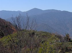
Mount Guyot is a mountain in the eastern Great Smoky Mountains
, located in
the southeastern United States. At 6621 feet (2,018.1 m) above sea level, Guyot is the fourth-highest
summit in the eastern U.S., and the second-highest in the Great Smoky Mountains National Park
http://www.nps.gov/grsm/naturescience/mountains.htm. While the mountain is remote, the Appalachian Trail
crosses its south slope,
passing to within 300 feet (91.4 m) of the summit.
Mount Guyot lies on the Tennessee-North Carolina border, between Sevier County
and
Haywood County
. There are two peaks atop the mountain, appx. one-half mile apart,
with the southwestern peak being the true summit. The mountain rises 3600 feet (1,097.3 m) above its
eastern base near Walnut Bottomhttp://www.topozone.com/map.asp?lat=35.71641&lon=-83.16489&datum=nad27&layer=DRG and 4000 feet (1,219.2 m) above its western base near Greenbrier Cove
. Ramsay Cascades, one of the park's most spectacular waterfalls, spills down a sandstone cliff near the bottom of Guyot's western
slope.
A dense stand of Southern Appalachian spruce-fir forest
coats the summit and upper slopes of Guyot. Human settlement never expanded deep into the eastern Smokies, so the area around Guyot and adjacent
peaks suffered substantially less disturbance than the mountains in the western or
central parts of the range. A long hike and a challenging bushwhack are required
to reach the summit.
rocks of the Ocoee Supergroup, formed
from ocean sediments approximately one billion years ago. The mountain is underlain by
Thunderhead sandstone, which is common throughout the Smokies. The Thunderhead sandstone
was thrust over Roaring Fork sandstone several hundred million years ago. Mt. Guyot itself
was formed during the Appalachian orogeny over 200 million years ago, when the North American and African plates collided, thrusting the rock upward.
 Mount Guyot was named in honor of Swiss geographer Arnold Guyot by Guyot's friend, Samuel
Buckley. Buckley was a naturalist who accompanied Thomas Lanier Clingman
on a survey
expedition to the crest of the Smokies in 1858. While Buckley's measurements were often wildly inaccurate, Guyot himself
conducted an expedition the following year, recording more accurate elevations and giving
preliminary names to various peaks along the crest. Guyot measured the elevation of Mt. Guyot at 6636 feet (2,022.7 m), missing the modern
measurement by just 15 feet (4.6 m)..
 Regarding the Eastern Smokies, surveyors and authors alike agreed on one
thing: the region was very remote and isolated. Guyot himself said of the area, "neither the
white man or the Indian hunter venture in this wilderness." For Horace Kephart
, who wrote extensively on the Smoky Mountains in the
early 1900s, Mt. Guyot was the climax of a dense, virtually-insurmountable wilderness:
Kephart goes on to relate the account of James Ferris and his wife, two naturalists who
bushwhacked their way across the crest of the Smokies to Mt. Guyot in 1900. According to Mrs.
Ferris:
Mt. Guyot remained isolated until the CCC
constructed a segment of the Appalachian Trail
across the mountain's western slope in 1935. Although the trail opened up the heart of the Eastern Smokies to backpackers, access remained relatively difficult. According to author Laura Thornborough, who climbed Guyot in the late 1930s:
Thornborough followed the route out of Greenbrier that ascends Guyot's western slope. She recalled that "there was no trail to Guyot, not even a dim one, but our guides knew the way." The party followed Ramsay Prong until it became "a mere trickle of water," and emerged near modern-day Guyot Spring. From the state line, they found a "dim trail" leading to the summit. Thornborough concluded her report by saying, "if it is wilderness you want, then go to Guyot."
 The Appalachian Trail
and the Balsam Mountain Trail intersect just south of Guyot
at Tricorner Knob
. They are the only maintained trails to traverse the mountain.
From the Cosby
Campground (specifically behind Campsite B51), the Snake Den Ridge Trail
winds 5.3 miles (8.5 km) to its intersection with the Appalachian Trail at Inadu Knob. From this
intersection, it is approximately 2 miles (3.2 km) to Guyot Spring, on Mt. Guyot's west slope.
A 15 miles (24.1 km) section of the Appalachian Trail stretches from Newfound Gap
to Tricorner Knob
,
near Guyot's south slope. The Appalachian-Balsam Trail intersection is approximately 13 miles (20.9 km) from Balsam Mountain Road, a gravel road
that begins near Cherokee
, North Carolina.
While Guyot's eastern slope is very steep, its western slope, known as Guyot Spur, descends gradually for nearly five miles to the Little Pigeon River
. A well-known bushwhack follows the creek
on the north side of Guyot Spur, starting at Ramsay Cascades and emerging on the Appalachian
Trail near Guyot Spring (probably the same path Thornborough's guides followed in the 1930s). This route is approximately eight miles from the Ramsay Cascades Trail parking area, four miles (6 km) of which are maintained trail.
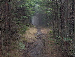
While the summit is less than a half-mile from the Appalachian Trail, the thick forest makes any bushwhack a challenge. A faint manway rises from Guyot Spring to the northern summit, although the manway is heavily overgrown. Dead fraser fir blowdowns and low visibility complicate navigation from any direction.
Great Smoky Mountains
The Great Smoky Mountains are a mountain range rising along the Tennessee–North Carolina border in the southeastern United States. They are a subrange of the Appalachian Mountains, and form part of the Blue Ridge Physiographic Province. The range is sometimes called the Smoky Mountains or the...
, located in
the southeastern United States. At 6621 feet (2,018.1 m) above sea level, Guyot is the fourth-highest
summit in the eastern U.S., and the second-highest in the Great Smoky Mountains National Park
Great Smoky Mountains National Park
Great Smoky Mountains National Park is a United States National Park and UNESCO World Heritage Site that straddles the ridgeline of the Great Smoky Mountains, part of the Blue Ridge Mountains, which are a division of the larger Appalachian Mountain chain. The border between Tennessee and North...
http://www.nps.gov/grsm/naturescience/mountains.htm. While the mountain is remote, the Appalachian Trail
Appalachian Trail
The Appalachian National Scenic Trail, generally known as the Appalachian Trail or simply the AT, is a marked hiking trail in the eastern United States extending between Springer Mountain in Georgia and Mount Katahdin in Maine. It is approximately long...
crosses its south slope,
passing to within 300 feet (91.4 m) of the summit.
Mount Guyot lies on the Tennessee-North Carolina border, between Sevier County
Sevier County, Tennessee
Sevier County is a county of the state of Tennessee, United States. Its population was 71,170 at the 2000 United States Census. It is included in the Sevierville, Tennessee, Micropolitan Statistical Area, which is included in the Knoxville-Sevierville-La Follette, TN Combined Statistical Area. The...
and
Haywood County
Haywood County, North Carolina
-National protected areas:* Blue Ridge Parkway * Great Smoky Mountains National Park * Pisgah National Forest -Major Highways & Roads:* Interstate 40* U.S. Highway 19* U.S. Highway 23* U.S. Highway 74* U.S...
. There are two peaks atop the mountain, appx. one-half mile apart,
with the southwestern peak being the true summit. The mountain rises 3600 feet (1,097.3 m) above its
eastern base near Walnut Bottomhttp://www.topozone.com/map.asp?lat=35.71641&lon=-83.16489&datum=nad27&layer=DRG and 4000 feet (1,219.2 m) above its western base near Greenbrier Cove
Greenbrier (Great Smoky Mountains)
Greenbrier is a valley in the northern Great Smoky Mountains of Tennessee, located in the Southeastern United States. Now a recreational area, Greenbrier was once home to a string of Appalachian communities....
. Ramsay Cascades, one of the park's most spectacular waterfalls, spills down a sandstone cliff near the bottom of Guyot's western
slope.
A dense stand of Southern Appalachian spruce-fir forest
Southern Appalachian spruce-fir forest
The Southern Appalachian spruce-fir forest is a type of montane coniferous forest that grows in the highest elevations in the southern Appalachian Mountains of the eastern United States...
coats the summit and upper slopes of Guyot. Human settlement never expanded deep into the eastern Smokies, so the area around Guyot and adjacent
peaks suffered substantially less disturbance than the mountains in the western or
central parts of the range. A long hike and a challenging bushwhack are required
to reach the summit.
Geology
Mount Guyot is composed of PrecambrianPrecambrian
The Precambrian is the name which describes the large span of time in Earth's history before the current Phanerozoic Eon, and is a Supereon divided into several eons of the geologic time scale...
rocks of the Ocoee Supergroup, formed
from ocean sediments approximately one billion years ago. The mountain is underlain by
Thunderhead sandstone, which is common throughout the Smokies. The Thunderhead sandstone
was thrust over Roaring Fork sandstone several hundred million years ago. Mt. Guyot itself
was formed during the Appalachian orogeny over 200 million years ago, when the North American and African plates collided, thrusting the rock upward.
History
Buckley. Buckley was a naturalist who accompanied Thomas Lanier Clingman
Thomas Lanier Clingman
Thomas Lanier Clingman , known as the "Prince of Politicians," was a Democratic member of the United States House of Representatives from 1843 to 1845 and from 1847 to 1858, and U.S. senator from the state of North Carolina between 1858 and 1861...
on a survey
expedition to the crest of the Smokies in 1858. While Buckley's measurements were often wildly inaccurate, Guyot himself
conducted an expedition the following year, recording more accurate elevations and giving
preliminary names to various peaks along the crest. Guyot measured the elevation of Mt. Guyot at 6636 feet (2,022.7 m), missing the modern
measurement by just 15 feet (4.6 m)..
thing: the region was very remote and isolated. Guyot himself said of the area, "neither the
white man or the Indian hunter venture in this wilderness." For Horace Kephart
Horace Kephart
Horace Kephart was an American travel writer and librarian, best known as the author of Our Southern Highlanders, about his life in the Great Smoky Mountains of western North Carolina.-Biography:...
, who wrote extensively on the Smoky Mountains in the
early 1900s, Mt. Guyot was the climax of a dense, virtually-insurmountable wilderness:
The most rugged and difficult part of the Smokies (and of the United States east of Colorado) is in the sawtooth mountains between Collins and Guyot, at the headwaters of the Okona Lufty River. I know but few men who have ever followed this part of the divide...
Kephart goes on to relate the account of James Ferris and his wife, two naturalists who
bushwhacked their way across the crest of the Smokies to Mt. Guyot in 1900. According to Mrs.
Ferris:
The Tennesseeans seem afraid of the mountains, and the CherokeeCherokeeThe Cherokee are a Native American people historically settled in the Southeastern United States . Linguistically, they are part of the Iroquoian language family...
s of North Carolina equally so; for, two miles (3 km) from camp, all traces of man, except surveyors' marks, had
disappeared.
Mt. Guyot remained isolated until the CCC
Civilian Conservation Corps
The Civilian Conservation Corps was a public work relief program that operated from 1933 to 1942 in the United States for unemployed, unmarried men from relief families, ages 18–25. A part of the New Deal of President Franklin D...
constructed a segment of the Appalachian Trail
Appalachian Trail
The Appalachian National Scenic Trail, generally known as the Appalachian Trail or simply the AT, is a marked hiking trail in the eastern United States extending between Springer Mountain in Georgia and Mount Katahdin in Maine. It is approximately long...
across the mountain's western slope in 1935. Although the trail opened up the heart of the Eastern Smokies to backpackers, access remained relatively difficult. According to author Laura Thornborough, who climbed Guyot in the late 1930s:
My first of three trips to the top of Mt. Guyot remains sharply etched in my memory. It was the hardest, roughest and most exhausting of all the trips I have ever made in the Great Smokies.
Thornborough followed the route out of Greenbrier that ascends Guyot's western slope. She recalled that "there was no trail to Guyot, not even a dim one, but our guides knew the way." The party followed Ramsay Prong until it became "a mere trickle of water," and emerged near modern-day Guyot Spring. From the state line, they found a "dim trail" leading to the summit. Thornborough concluded her report by saying, "if it is wilderness you want, then go to Guyot."
Access
Appalachian Trail
The Appalachian National Scenic Trail, generally known as the Appalachian Trail or simply the AT, is a marked hiking trail in the eastern United States extending between Springer Mountain in Georgia and Mount Katahdin in Maine. It is approximately long...
and the Balsam Mountain Trail intersect just south of Guyot
at Tricorner Knob
Tricorner Knob
Tricorner Knob is a mountain in the Great Smoky Mountains, located in the Southeastern United States. It has an elevation of 6,120 feet , with 160 feet of clean prominence. The Appalachian Trail and Balsam Mountain Trail intersect near the mountain's summit, making Tricorner Knob the great...
. They are the only maintained trails to traverse the mountain.
From the Cosby
Cosby, Tennessee
Cosby is an unincorporated community in Cocke County, Tennessee, United States. Although it is not a census-designated place, the ZIP Code Tabulation Area for the ZIP Code that serves Cosby had a population of 5,201 as of the 2000 U.S. Census...
Campground (specifically behind Campsite B51), the Snake Den Ridge Trail
Snake Den Ridge Trail
The Snake Den Ridge Trail is an American hiking trail in the Great Smoky Mountains National Park of Cocke County, Tennessee. Winding its way up the backbone-like crest of Snake Den Ridge, the trail connects the Cosby Campground to the Appalachian Trail and provides the quickest access to the high...
winds 5.3 miles (8.5 km) to its intersection with the Appalachian Trail at Inadu Knob. From this
intersection, it is approximately 2 miles (3.2 km) to Guyot Spring, on Mt. Guyot's west slope.
A 15 miles (24.1 km) section of the Appalachian Trail stretches from Newfound Gap
Newfound Gap
Newfound Gap is a mountain pass located near the center of the Great Smoky Mountains National Park of the southern Appalachian Mountains in the United States of America. Situated along the border of Tennessee and North Carolina, the state line crosses the gap, as does U.S...
to Tricorner Knob
Tricorner Knob
Tricorner Knob is a mountain in the Great Smoky Mountains, located in the Southeastern United States. It has an elevation of 6,120 feet , with 160 feet of clean prominence. The Appalachian Trail and Balsam Mountain Trail intersect near the mountain's summit, making Tricorner Knob the great...
,
near Guyot's south slope. The Appalachian-Balsam Trail intersection is approximately 13 miles (20.9 km) from Balsam Mountain Road, a gravel road
that begins near Cherokee
Cherokee, North Carolina
Cherokee is a town in Swain County, North Carolina, USA, within the Qualla Boundary land trust. It is located in the Oconaluftee River Valley, near the intersection of U.S. Route 19 and U.S...
, North Carolina.
While Guyot's eastern slope is very steep, its western slope, known as Guyot Spur, descends gradually for nearly five miles to the Little Pigeon River
Little Pigeon River (Tennessee)
The Little Pigeon River is a river located entirely within Sevier County, Tennessee.It rises from a series of streams which flow together on the dividing ridge between the states of Tennessee and North Carolina inside the boundary of the Great Smoky Mountains National Park. The river is subdivided...
. A well-known bushwhack follows the creek
on the north side of Guyot Spur, starting at Ramsay Cascades and emerging on the Appalachian
Trail near Guyot Spring (probably the same path Thornborough's guides followed in the 1930s). This route is approximately eight miles from the Ramsay Cascades Trail parking area, four miles (6 km) of which are maintained trail.
While the summit is less than a half-mile from the Appalachian Trail, the thick forest makes any bushwhack a challenge. A faint manway rises from Guyot Spring to the northern summit, although the manway is heavily overgrown. Dead fraser fir blowdowns and low visibility complicate navigation from any direction.
External links
- Great Smoky Mountains National Park Trail Map - Large file in .pdf format.
- Tricorner Knob Shelter - Information on the back country shelter near Mt. Guyot's southern slope.
- South Beyond 6000 in the Eastern Smokies - Information provided by the Carolina Hiking Club for climbing Mt. Guyot and other nearby high peaks.
- The Mount Guyot page at Summitpost.org