
Northern boundary of Massachusetts
Encyclopedia
The northern boundary of the U.S. state
of Massachusetts
adjoins two other states - Vermont
and New Hampshire
. The majority of the line is roughly a straight line from the northwest corner of the state (42°44′44.7"N 73°15′54.13"W NAD27) east to a point north of Lowell. East of that point, the border is a series of lines about 3 miles (5 km) north of the curving Merrimack River
, ending in the Atlantic Ocean
.
gave the colony the land between the Merrimack River
and Charles River
. Specifically, the southern border was to be the line of latitude either 3 miles (4.8 km) south of Massachusetts Bay
or 3 miles south of the southernmost bend of the Charles River, whichever was farther south. The northern border was to be 3 miles north of the northernmost bend of the Merrimack River. Between these lines of latitude the grant extended from the Atlantic to the Pacific. In 1629 the rivers had not been fully explored and the actual borders of the colony were uncertain. It turned out that the southernmost bend of the Charles is south of the southern curve of Massachusetts Bay. The line of latitude three miles south of the river's southernmost bend, approximately 42°2′ north, forms the basis of the southern border of Massachusetts to the present day. The Merrimack River turned out to originate farther north than expected, flowing south for most of its course and only turning eastward in its last several miles. Thus the 1629 grant gave the colony most of what is today New Hampshire and all of the original 1629 grant that formed the basis of colonial New Hampshire, but it took many decades before this was fully understood.
A new charter was granted to the Province of Massachusetts Bay
in 1691, which merged the Colony with the Colony of New Plymouth
, as well as present-day Maine
and New Brunswick
. The northern boundary of what was now the southern piece remained as defined in 1629.
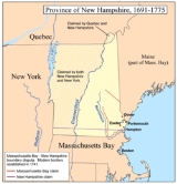
 The Province of New Hampshire
and Province of Massachusetts Bay
had disagreements over their mutual boundaries. With respect to the southern boundary of New Hampshire, the two provinces disagreed on the meaning of "three miles northward of the Merrimack River, or any part thereof". New Hampshire drew a line from three miles north of the mouth of the river, while Massachusetts claimed a line three miles north of the northernmost part of the river, taking its territory far north past what is now Concord, New Hampshire
. New Hampshire appealed to King George II
, who in 1740 decreed the boundary to run along a curved line three miles from the river between the ocean and a point three miles north of Pawtucket Falls
(Lowell), where the river begins to turn north. From there a line was to be drawn due west to meet the western boundary of Massachusetts (fixed in 1773 with the Province of New York
). The line actually runs slightly northwest to southeast, so it follows no line of latitude. This gave New Hampshire even more than it had claimed, as Pawtucket Falls was south of the mouth of the Merrimack. At this time, the present northern boundary of Massachusetts was established.
New Hampshire claimed all the land west to roughly the present western boundary of Vermont
, while New York claimed east to the Connecticut River
, Vermont's present eastern boundary. A 1764 ruling established the ordinary low-water line on the west bank of the Connecticut River to be the border, but the intermediate territory - which had been sold off by New Hampshire - soon declared independence as the Vermont Republic
.
U.S. state
A U.S. state is any one of the 50 federated states of the United States of America that share sovereignty with the federal government. Because of this shared sovereignty, an American is a citizen both of the federal entity and of his or her state of domicile. Four states use the official title of...
of Massachusetts
Massachusetts
The Commonwealth of Massachusetts is a state in the New England region of the northeastern United States of America. It is bordered by Rhode Island and Connecticut to the south, New York to the west, and Vermont and New Hampshire to the north; at its east lies the Atlantic Ocean. As of the 2010...
adjoins two other states - Vermont
Vermont
Vermont is a state in the New England region of the northeastern United States of America. The state ranks 43rd in land area, , and 45th in total area. Its population according to the 2010 census, 630,337, is the second smallest in the country, larger only than Wyoming. It is the only New England...
and New Hampshire
New Hampshire
New Hampshire is a state in the New England region of the northeastern United States of America. The state was named after the southern English county of Hampshire. It is bordered by Massachusetts to the south, Vermont to the west, Maine and the Atlantic Ocean to the east, and the Canadian...
. The majority of the line is roughly a straight line from the northwest corner of the state (42°44′44.7"N 73°15′54.13"W NAD27) east to a point north of Lowell. East of that point, the border is a series of lines about 3 miles (5 km) north of the curving Merrimack River
Merrimack River
The Merrimack River is a river in the northeastern United States. It rises at the confluence of the Pemigewasset and Winnipesaukee rivers in Franklin, New Hampshire, flows southward into Massachusetts, and then flows northeast until it empties into the Atlantic Ocean at Newburyport...
, ending in the Atlantic Ocean
Atlantic Ocean
The Atlantic Ocean is the second-largest of the world's oceanic divisions. With a total area of about , it covers approximately 20% of the Earth's surface and about 26% of its water surface area...
.
History
The 1629 charter of the Massachusetts Bay ColonyMassachusetts Bay Colony
The Massachusetts Bay Colony was an English settlement on the east coast of North America in the 17th century, in New England, situated around the present-day cities of Salem and Boston. The territory administered by the colony included much of present-day central New England, including portions...
gave the colony the land between the Merrimack River
Merrimack River
The Merrimack River is a river in the northeastern United States. It rises at the confluence of the Pemigewasset and Winnipesaukee rivers in Franklin, New Hampshire, flows southward into Massachusetts, and then flows northeast until it empties into the Atlantic Ocean at Newburyport...
and Charles River
Charles River
The Charles River is an long river that flows in an overall northeasterly direction in eastern Massachusetts, USA. From its source in Hopkinton, the river travels through 22 cities and towns until reaching the Atlantic Ocean at Boston...
. Specifically, the southern border was to be the line of latitude either 3 miles (4.8 km) south of Massachusetts Bay
Massachusetts Bay
The Massachusetts Bay, also called Mass Bay, is one of the largest bays of the Atlantic Ocean which forms the distinctive shape of the coastline of the U.S. state of Massachusetts. Its waters extend 65 miles into the Atlantic Ocean. Massachusetts Bay includes the Boston Harbor, Dorchester Bay,...
or 3 miles south of the southernmost bend of the Charles River, whichever was farther south. The northern border was to be 3 miles north of the northernmost bend of the Merrimack River. Between these lines of latitude the grant extended from the Atlantic to the Pacific. In 1629 the rivers had not been fully explored and the actual borders of the colony were uncertain. It turned out that the southernmost bend of the Charles is south of the southern curve of Massachusetts Bay. The line of latitude three miles south of the river's southernmost bend, approximately 42°2′ north, forms the basis of the southern border of Massachusetts to the present day. The Merrimack River turned out to originate farther north than expected, flowing south for most of its course and only turning eastward in its last several miles. Thus the 1629 grant gave the colony most of what is today New Hampshire and all of the original 1629 grant that formed the basis of colonial New Hampshire, but it took many decades before this was fully understood.
A new charter was granted to the Province of Massachusetts Bay
Province of Massachusetts Bay
The Province of Massachusetts Bay was a crown colony in North America. It was chartered on October 7, 1691 by William and Mary, the joint monarchs of the kingdoms of England and Scotland...
in 1691, which merged the Colony with the Colony of New Plymouth
Plymouth Colony
Plymouth Colony was an English colonial venture in North America from 1620 to 1691. The first settlement of the Plymouth Colony was at New Plymouth, a location previously surveyed and named by Captain John Smith. The settlement, which served as the capital of the colony, is today the modern town...
, as well as present-day Maine
Maine
Maine is a state in the New England region of the northeastern United States, bordered by the Atlantic Ocean to the east and south, New Hampshire to the west, and the Canadian provinces of Quebec to the northwest and New Brunswick to the northeast. Maine is both the northernmost and easternmost...
and New Brunswick
New Brunswick
New Brunswick is one of Canada's three Maritime provinces and is the only province in the federation that is constitutionally bilingual . The provincial capital is Fredericton and Saint John is the most populous city. Greater Moncton is the largest Census Metropolitan Area...
. The northern boundary of what was now the southern piece remained as defined in 1629.
Province of New Hampshire
The Province of New Hampshire is a name first given in 1629 to the territory between the Merrimack and Piscataqua rivers on the eastern coast of North America. It was formally organized as an English royal colony on October 7, 1691, during the period of English colonization...
and Province of Massachusetts Bay
Province of Massachusetts Bay
The Province of Massachusetts Bay was a crown colony in North America. It was chartered on October 7, 1691 by William and Mary, the joint monarchs of the kingdoms of England and Scotland...
had disagreements over their mutual boundaries. With respect to the southern boundary of New Hampshire, the two provinces disagreed on the meaning of "three miles northward of the Merrimack River, or any part thereof". New Hampshire drew a line from three miles north of the mouth of the river, while Massachusetts claimed a line three miles north of the northernmost part of the river, taking its territory far north past what is now Concord, New Hampshire
Concord, New Hampshire
The city of Concord is the capital of the state of New Hampshire in the United States. It is also the county seat of Merrimack County. As of the 2010 census, its population was 42,695....
. New Hampshire appealed to King George II
George II of Great Britain
George II was King of Great Britain and Ireland, Duke of Brunswick-Lüneburg and Archtreasurer and Prince-elector of the Holy Roman Empire from 11 June 1727 until his death.George was the last British monarch born outside Great Britain. He was born and brought up in Northern Germany...
, who in 1740 decreed the boundary to run along a curved line three miles from the river between the ocean and a point three miles north of Pawtucket Falls
Pawtucket Falls (Massachusetts)
Pawtucket Falls is the name of a waterfall on the Merrimack River at Lowell, Massachusetts. The waterfall and rapids below it drop a total of 32 feet in a little under a mile., and was an important fishing ground for the Pennacook Indians in pre-colonial times.This location was used as a benchmark...
(Lowell), where the river begins to turn north. From there a line was to be drawn due west to meet the western boundary of Massachusetts (fixed in 1773 with the Province of New York
Province of New York
The Province of New York was an English and later British crown territory that originally included all of the present U.S. states of New York, New Jersey, Delaware and Vermont, along with inland portions of Connecticut, Massachusetts, and Maine, as well as eastern Pennsylvania...
). The line actually runs slightly northwest to southeast, so it follows no line of latitude. This gave New Hampshire even more than it had claimed, as Pawtucket Falls was south of the mouth of the Merrimack. At this time, the present northern boundary of Massachusetts was established.
New Hampshire claimed all the land west to roughly the present western boundary of Vermont
Vermont
Vermont is a state in the New England region of the northeastern United States of America. The state ranks 43rd in land area, , and 45th in total area. Its population according to the 2010 census, 630,337, is the second smallest in the country, larger only than Wyoming. It is the only New England...
, while New York claimed east to the Connecticut River
Connecticut River
The Connecticut River is the largest and longest river in New England, and also an American Heritage River. It flows roughly south, starting from the Fourth Connecticut Lake in New Hampshire. After flowing through the remaining Connecticut Lakes and Lake Francis, it defines the border between the...
, Vermont's present eastern boundary. A 1764 ruling established the ordinary low-water line on the west bank of the Connecticut River to be the border, but the intermediate territory - which had been sold off by New Hampshire - soon declared independence as the Vermont Republic
Vermont Republic
The term Vermont Republic has been used by later historians for the government of what became modern Vermont from 1777 to 1791. In July 1777 delegates from 28 towns met and declared independence from jurisdictions and land claims of British colonies in New Hampshire and New York. They also...
.