
Nine Standards Rigg
Encyclopedia
Nine Standards Rigg is the summit of Hartley Fell in the Pennine Hills of England. It lies near the boundary between Cumbria
and North Yorkshire
, a few miles south-east of Kirkby Stephen
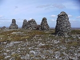
and approx 700 metres outside the Yorkshire Dales National Park. The name is derived from a group of standing stones or cairn
s, the Nine Standards, located near the summit. The fell is listed as Nine Standards Rigg, rather than Hartley Fell, in Alan Dawson's book The Hewitts and Marilyns of England.
The Nine Standards themselves, some of which were originally more than four metres high, are on the line of the Coast to Coast Walk
between Kirkby Stephen and Keld
, and are just to the north of the fell's summit. Situated at a height of 650 m, their original purpose is uncertain but one possibility is that they marked the boundary
between Westmorland
and Swaledale
.
The Nine Standards offer a better viewpoint than the Ordnance Survey
trig point
that marks the actual summit of the fell. Cross Fell
and Great Dun Fell
can be seen to the north west and Wild Boar Fell
and the Howgills
feature in the south west. The High Street Range
of the eastern Lake District can be seen further to the west. Great Shunner Fell
, crossed by the Pennine Way
, and Rogan's Seat
lie to the south east.
Cumbria
Cumbria , is a non-metropolitan county in North West England. The county and Cumbria County Council, its local authority, came into existence in 1974 after the passage of the Local Government Act 1972. Cumbria's largest settlement and county town is Carlisle. It consists of six districts, and in...
and North Yorkshire
North Yorkshire
North Yorkshire is a non-metropolitan or shire county located in the Yorkshire and the Humber region of England, and a ceremonial county primarily in that region but partly in North East England. Created in 1974 by the Local Government Act 1972 it covers an area of , making it the largest...
, a few miles south-east of Kirkby Stephen
Kirkby Stephen
Kirkby Stephen is a civil parish and small market town in Cumbria, in North West England which historically, is part of Westmorland. The town is located on the A685, surrounded by sparsely populated hill country, and about from the two nearest larger towns, Kendal and Penrith...
and approx 700 metres outside the Yorkshire Dales National Park. The name is derived from a group of standing stones or cairn
Cairn
Cairn is a term used mainly in the English-speaking world for a man-made pile of stones. It comes from the or . Cairns are found all over the world in uplands, on moorland, on mountaintops, near waterways and on sea cliffs, and also in barren desert and tundra areas...
s, the Nine Standards, located near the summit. The fell is listed as Nine Standards Rigg, rather than Hartley Fell, in Alan Dawson's book The Hewitts and Marilyns of England.
The Nine Standards themselves, some of which were originally more than four metres high, are on the line of the Coast to Coast Walk
Coast to Coast Walk
The Coast to Coast Walk is a 192-mile unofficial and mostly unsignposted long distance footpath in Northern England...
between Kirkby Stephen and Keld
Keld, North Yorkshire
Keld is a hamlet in the English county of North Yorkshire. It is situated on Swaledale, in the Yorkshire Dales. The name derives from the Viking word Kelda meaning a spring, and the village was once called Appletre Kelde - the spring near the apple trees.Keld is the crossing point of the Coast to...
, and are just to the north of the fell's summit. Situated at a height of 650 m, their original purpose is uncertain but one possibility is that they marked the boundary
Boundary marker
A boundary marker, boundary stone or border stone is a robust physical marker that identifies the start of a land boundary or the change in a boundary, especially a change in a direction of a boundary...
between Westmorland
Westmorland
Westmorland is an area of North West England and one of the 39 historic counties of England. It formed an administrative county from 1889 to 1974, after which the entirety of the county was absorbed into the new county of Cumbria.-Early history:...
and Swaledale
Swaledale
Swaledale is one of the northernmost dales in the Yorkshire Dales National Park in northern England. It is the dale of the River Swale on the east side of the Pennines in North Yorkshire.-Geographical overview:...
.
The Nine Standards offer a better viewpoint than the Ordnance Survey
Ordnance Survey
Ordnance Survey , an executive agency and non-ministerial government department of the Government of the United Kingdom, is the national mapping agency for Great Britain, producing maps of Great Britain , and one of the world's largest producers of maps.The name reflects its creation together with...
trig point
Trig point
A triangulation station, also known as a triangulation pillar, trigonometrical station, trigonometrical point, trig station, trig beacon or trig point, and sometimes informally as a trig, is a fixed surveying station, used in geodetic surveying and other surveying projects in its vicinity...
that marks the actual summit of the fell. Cross Fell
Cross Fell
Cross Fell is the highest point in the Pennine Hills of northern England and the highest point in England outside of the Lake District.The summit, at , is a stony plateau, part of a long ridge running North West to South East, which also incorporates Little Dun Fell at and Great Dun Fell at...
and Great Dun Fell
Great Dun Fell
Great Dun Fell is the second-highest hill in the Pennine range, United Kingdom, lying two miles south along the watershed from Cross Fell, its higher neighbour...
can be seen to the north west and Wild Boar Fell
Wild Boar Fell
Wild Boar Fell is a mountain in Mallerstang on the eastern edge of Cumbria, England. At , it is either the 4th highest fell in the Yorkshire Dales or the 5th, whether counting nearby High Seat or not...
and the Howgills
Howgill Fells
The Howgill Fells are hills in Northern England between the Lake District and the Yorkshire Dales, lying roughly in between the vertices of a triangle made by the towns of Sedbergh, Kirkby Stephen and Tebay....
feature in the south west. The High Street Range
High Street (Lake District)
High Street is a fell in the English Lake District. At 828 metres , its summit is the highest point in the far eastern part of the national park. The fell is named after the Roman road which ran over the summit.-History and Naming:...
of the eastern Lake District can be seen further to the west. Great Shunner Fell
Great Shunner Fell
Great Shunner Fell is the third highest mountain in the Yorkshire Dales, North Yorkshire, England, and the highest point in Wensleydale; at 716 metres above sea level.The Pennine Way passes over its summit, on the way from Hawes to Keld...
, crossed by the Pennine Way
Pennine Way
The Pennine Way is a National Trail in England. The trail runs from Edale, in the northern Derbyshire Peak District, north through the Yorkshire Dales and the Northumberland National Park and ends at Kirk Yetholm, just inside the Scottish border. The path runs along the Pennine hills, sometimes...
, and Rogan's Seat
Rogan's Seat
Rogan's Seat is a remote hill located near East Stonesdale and Gunnerside Gill, in the Yorkshire Dales in England.It is a high expanse of moorland that stretches alongside Swaledale, Swinner Gill and Gunnerside Gill...
lie to the south east.