
Niangala, New South Wales
Encyclopedia
Northern Tablelands, New South Wales
The Northern Tablelands, also known as the New England Tableland, is a plateau and a region of the Great Dividing Range in northern New South Wales, Australia. It includes the New England Range, the narrow highlands area of the New England region, stretching from the Moonbi Range in the south to...
area of New South Wales
New South Wales
New South Wales is a state of :Australia, located in the east of the country. It is bordered by Queensland, Victoria and South Australia to the north, south and west respectively. To the east, the state is bordered by the Tasman Sea, which forms part of the Pacific Ocean. New South Wales...
, Australia
Australia
Australia , officially the Commonwealth of Australia, is a country in the Southern Hemisphere comprising the mainland of the Australian continent, the island of Tasmania, and numerous smaller islands in the Indian and Pacific Oceans. It is the world's sixth-largest country by total area...
. It is on the Moonbi Range
Moonbi Range
The Moonbi Range is a chain of hills which forms a part of the Northern Tablelands, New South Wales, Australia.The range is located roughly 20 kilometres north east of the city of Tamworth situated at the bottom of the Wentworth Mounds, which is part of the Moonbi Range. These mounds form a spur of...
which is part of the Great Dividing Range
Great Dividing Range
The Great Dividing Range, or the Eastern Highlands, is Australia's most substantial mountain range and the third longest in the world. The range stretches more than 3,500 km from Dauan Island off the northeastern tip of Queensland, running the entire length of the eastern coastline through...
, at approximately 1300 metres (4,265 ft) above sea level. The village is in Walcha parish in Parry County
Parry County, New South Wales
Parry County is one of the 141 Cadastral divisions of New South Wales. It is bounded by the Peel River and Cockburn River on the north, near Tamworth. The Moonbi Range is on the eastern boundary, and the Peel Range on the western boundary. The Great Dividing Range is the boundary to the south-east...
. At the 2006 census
Census in Australia
The Australian census is administered once every five years by the Australian Bureau of Statistics. The most recent census was conducted on 9 August 2011; the next will be conducted in 2016. Prior to the introduction of regular censuses in 1961, they had also been run in 1901, 1911, 1921, 1933,...
, Niangala and the surrounding area had a population of 163.
Geographically isolated, the village is situated among pine tree plantations. Access to the community requires travel along some stretches of dirt road, which can be hazardous in wet or snow conditions. Winters are cold there, often with several falls of snow during the season.
Niangala, meaning ‘eclipse’, was first known as Bungadore, ‘blackrocks’ and is situated at the head of Bungendore Creek.
History
In 1836 William Telfer marked a tree line from Port StephensPort Stephens
Port Stephens is a large natural harbour located about north-east of Sydney in New South Wales, Australia. It lies wholly within the Port Stephens Local Government Area although its northern shoreline forms the boundary between the Port Stephens and Great Lakes LGAs...
through Barrington
Barrington, New South Wales
Barrington is a small village on the Barrington River, north-west of Gloucester, New South Wales, Australia on Thunderbolts Way....
, Nowendoc
Nowendoc, New South Wales
Nowendoc is a parish and village on the Northern Tablelands, New South Wales, Australia. The town is located 360 km north of the state capital, Sydney, 66 km south of Walcha and is in the Walcha Shire Local Government Area...
and on to Ogunbil. The Australian Agricultural Company
Australian Agricultural Company
The Australian Agricultural Company is a company which serves to improve beef cattle production through responsible natural resource and land use...
set up stations and resting places for their travelling sheep along this route to be known as the ‘Peel Line’. This route was steep and rugged but it was much more efficient than the previously used route, via Maitland. The present roads, Thunderbolts Way
Thunderbolts Way
Thunderbolts Way is a New South Wales country road linking Gloucester to Walcha , Uralla, where it very briefly joins the New England Highway and, to Copes Creek, south of the Gwydir Highway intersection at Inverell...
from Gloucester
Gloucester, New South Wales
Gloucester is a town in the dairy and beef cattle country of the Manning district on the Mid North Coast of the state of New South Wales, Australia in the Gloucester Shire....
and the Topdale Road to Tamworth
Tamworth, New South Wales
Tamworth is a city in the New England region of New South Wales, Australia. Straddling the Peel River, Tamworth, which contains an estimated population of 47,595 people, is the major regional centre for southern New England and in the local government area of Tamworth Regional Council. The city...
, travel approximately the same route.
Niangala began as a gold mining settlement and by the end of October 1890, Niangala had five boarding houses, two butcheries, one blacksmith, a bakery and two stores. The Niangala post office opened on 1 December 1890 (it closed in 1977). and coach services travelled regularly from Walcha
Walcha, New South Wales
Walcha is a parish and town at the south-eastern edge of the Northern Tablelands, New South Wales, Australia.The town serves as the seat of Walcha Shire. Walcha is located 425 kilometres by road from Sydney at the intersection of the Oxley Highway and Thunderbolts Way...
to Niangala. The Public School was opened in 1891 for 28 children of the local gold miners and had one teacher. The school remained a one teacher school until 1980. This School reached its peak enrolment of 51 students in 1991. In 1891 the population was 300 and on 14 September 1893 Niangala was proclaimed a village. During 1901 residents were able to connect to the telephone, but it was not until 1966 that 33 customers accessed rural power.
Not many land selections were made in the area before 1900, as the Niangala Gold Field had been removed from the Conditional Purchase Act, but was available for annual lease. The only other metal to be seriously mined was manganese
Manganese
Manganese is a chemical element, designated by the symbol Mn. It has the atomic number 25. It is found as a free element in nature , and in many minerals...
which was taken during the 1930s to 1950s. Sheep and cattle breeding is the main industry, though there are now other diversified industries, particularly berry growing and extensive pine plantations that supply the local timber mill. Trout
Trout
Trout is the name for a number of species of freshwater and saltwater fish belonging to the Salmoninae subfamily of the family Salmonidae. Salmon belong to the same family as trout. Most salmon species spend almost all their lives in salt water...
fishing is a popular tourist attraction in the Niangala area and a visit to the area will reveal some interesting scenery.
On 13 October 2002 an F2 tornado
Tornado
A tornado is a violent, dangerous, rotating column of air that is in contact with both the surface of the earth and a cumulonimbus cloud or, in rare cases, the base of a cumulus cloud. They are often referred to as a twister or a cyclone, although the word cyclone is used in meteorology in a wider...
struck the Niangala region causing serious building, tree and livestock damage.
On 28 and 29 November 2008 Niangala received torrential rain that caused severe flooding and led to the area being declared a natural disaster area.
Today
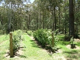
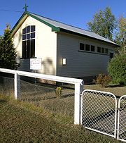
Niangala village is a remnant of the Australian gold rush days, leaving an old cemetery, a derelict gold crusher and a number of old buildings. There is a Church of England church that was built in 1964, a community hall and tennis courts. Today the village of Niangala has a population of about 30.Casey Stoner
Casey Stoner
Casey Stoner is an Australian professional motorcycle racer. Born in Kurri Kurri, New South Wales, Australia and raised in Southport, Queensland, Stoner raced from a young age and moved to the United Kingdom to pursue a racing career...
the 2007 MotoGP World Champion and also 2008 Young Australian of the Year was raised in the Niangala area.
External links
- http://www.nnsw.com.au/niangala/community.html#EDUCATION
- http://www.nnsw.com.au/niangala/tourism.html Tourism