
Nowendoc, New South Wales
Encyclopedia

Northern Tablelands, New South Wales
The Northern Tablelands, also known as the New England Tableland, is a plateau and a region of the Great Dividing Range in northern New South Wales, Australia. It includes the New England Range, the narrow highlands area of the New England region, stretching from the Moonbi Range in the south to...
, Australia
Australia
Australia , officially the Commonwealth of Australia, is a country in the Southern Hemisphere comprising the mainland of the Australian continent, the island of Tasmania, and numerous smaller islands in the Indian and Pacific Oceans. It is the world's sixth-largest country by total area...
. The town is located 360 km north of the state capital, Sydney
Sydney
Sydney is the most populous city in Australia and the state capital of New South Wales. Sydney is located on Australia's south-east coast of the Tasman Sea. As of June 2010, the greater metropolitan area had an approximate population of 4.6 million people...
, 66 km south of Walcha
Walcha, New South Wales
Walcha is a parish and town at the south-eastern edge of the Northern Tablelands, New South Wales, Australia.The town serves as the seat of Walcha Shire. Walcha is located 425 kilometres by road from Sydney at the intersection of the Oxley Highway and Thunderbolts Way...
and is in the Walcha Shire Local Government Area
Local Government Area
A local government area is an administrative division of a country that a local government is responsible for. The size of an LGA varies by country but it is generally a subdivision of a state, province, division, or territory....
. A sealed road, Thunderbolts Way
Thunderbolts Way
Thunderbolts Way is a New South Wales country road linking Gloucester to Walcha , Uralla, where it very briefly joins the New England Highway and, to Copes Creek, south of the Gwydir Highway intersection at Inverell...
, is about three hundred metres to the south of Nowendoc and provides links to the south and north.
History
In 1836 William Telfer marked a tree line from GloucesterGloucester, New South Wales
Gloucester is a town in the dairy and beef cattle country of the Manning district on the Mid North Coast of the state of New South Wales, Australia in the Gloucester Shire....
through Giro on the Barnard River, over Hungry Hill to Nowendoc and on to Ogunbil via White's Sugarloaf. The Australian Agricultural Company
Australian Agricultural Company
The Australian Agricultural Company is a company which serves to improve beef cattle production through responsible natural resource and land use...
(AACo) set up stations and resting places for their travelling sheep along this route to be known as the ‘Peel Line’. During the years 1840 to 1845 Nowendoc was one of the AACo outstations for their sheep. In 1857 John Hall surveyed 39 allotments to define the village of Nowendoc. Thomas Laurie discovered alluvial gold
Gold
Gold is a chemical element with the symbol Au and an atomic number of 79. Gold is a dense, soft, shiny, malleable and ductile metal. Pure gold has a bright yellow color and luster traditionally considered attractive, which it maintains without oxidizing in air or water. Chemically, gold is a...
there in 1872 and by 1873 there were about 100 people camping at Township Spur. By 1945 nearly all mining has ceased. Some dairy
Dairy
A dairy is a business enterprise established for the harvesting of animal milk—mostly from cows or goats, but also from buffalo, sheep, horses or camels —for human consumption. A dairy is typically located on a dedicated dairy farm or section of a multi-purpose farm that is concerned...
ing was done during the earlier years of settlement.
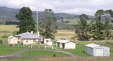
The village has a cemetery, church, school, sports ground, store, police station, Rural Fire Service station and community hall. A post office has operated intermittently from 1861 to 1979. The completion of the telephone line to Walcha in 1921 reduced the isolation of the area. Rural electricity was supplied during 1964-5 to those who made the contribution of £248/10/- towards the cost of connection. The local Uniting Church was officially opened in 1976.
At the 2006 census
Census in Australia
The Australian census is administered once every five years by the Australian Bureau of Statistics. The most recent census was conducted on 9 August 2011; the next will be conducted in 2016. Prior to the introduction of regular censuses in 1961, they had also been run in 1901, 1911, 1921, 1933,...
, Nowendoc and the surrounding area had a population of 157. The main industries nowadays are beef cattle breeding and timber.
Nowendoc is a centre for those keen on bushwalking, fishing and similar activities and lies near the top of the escarpment that contains the bulk of the Barrington Tops National Park
Barrington Tops National Park
Barrington Tops is a National Park in the Hunter Valley, approximately north of Sydney in New South Wales, Australia. The nearest towns are Scone, Singleton, Dungog, Gloucester and East Gresford....
. Many scenic walks and drives can be easily accessed from Nowendoc with the Nowendoc National Park
Nowendoc National Park
Nowendoc National Park is a park on the southern end of the Northern Tablelands and west of Nowendoc, New South Wales, Australia. It is located approximately 70 km south of Walcha and about 375 km north of Sydney....
nearby. Tennis, football and cricket are popular sports that enjoyed by residents. An annual rodeo
Rodeo
Rodeo is a competitive sport which arose out of the working practices of cattle herding in Spain, Mexico, and later the United States, Canada, South America and Australia. It was based on the skills required of the working vaqueros and later, cowboys, in what today is the western United States,...
is held on the Nowendoc sports ground.