

Moonbi Range
Encyclopedia
The Moonbi Range is a chain of hills which forms a part of the Northern Tablelands, New South Wales
, Australia
.
The range is located roughly 20 kilometres north east of the city of Tamworth
situated at the bottom of the Wentworth Mounds, which is part of the Moonbi Range. These mounds form a spur of the Great Dividing Range
where the Northwest Slopes meet to the Northern Tablelands. The Moonbi Range rises from 500 metres to about 1,300 m AHD
and it generally forms the divide between the drainage basins of the Cockburn River
to the south, and the Macdonald River
to the north, which are both themselves tributaries of the Namoi River
. The higher parts of the area often receive a snowfall in the winter, and the most well known mountain is called Black Jack (1,300 m).
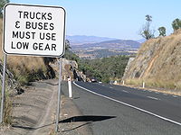
, the Moonbi Range is notable as it is a major uphill climb on the highway as the motorist ascends from Moonbi
at the foot of the 1st Moonbi Hill to the Northern Tablelands
and the village of Bendemeer
.
In 1832 Edward Gostwyck Cory blazed a track over the range that the existing highway has generally followed. A granite boulder named Cory’s Pillar (sometimes Cory’s Pillow or Cory’s Nightcap) commemorates where Cory is believed to have rested during his travels.
When Banjo Paterson was born in 1864, the Great Northern Road was still in poor condition making travel to the New England district for wagon teams very difficult. In his poem “Over the Range”, Andrew “Banjo” Paterson
wrote of the obstacle that the Moonbi Range created for travelers to the Northern Tablelands.
 ‘The Pinch’ was a pass over the First Moonbi Hill near Cory’s Pillar which involved a steep climb of about 200 metres. Here teamsters used to hitch several teams together to haul their wagons up this section. Descending the range loaded, they often dragged felled trees behind them to slow their descent down these steep slopes.
Capt. B. H. Martindale (Commissioner for Internal Communication) in his fourth report in 1860 was able to refer to “2 miles of road at the Moonbi’s Pass which has been greatly improved”. By 1865, the road section between Tamworth and Bendemeer had been cleared and fenced.
A second route was found through the Moonbi Ranges in the early 1870s which eliminated the steep section of “The (Blue) Pinch”.
In 1937 a new bitumen sealed route to eliminate the earlier “S-Bend” deviation and a steep section was built from Moonbi over the range. Reconstruction on the First Moonbi Hill which began in 1975 now continues on a 5 km section, which has double traffic lanes in each direction. Emergency stopping beds have been built running off the highway of both of the hills in case of vehicle brake failure.
The Moonbi Park lookout situated in a high area just off the New England Highway
roughly 25 km north of Tamworth, New South Wales
, offers a spectacular view of the areas south of the mountain from a huge granite boulder.
In August 1998 The New England Highway was closed for 8 hours after two truck-sized boulders fell onto the northbound highway, blocking it.
Northern Tablelands, New South Wales
The Northern Tablelands, also known as the New England Tableland, is a plateau and a region of the Great Dividing Range in northern New South Wales, Australia. It includes the New England Range, the narrow highlands area of the New England region, stretching from the Moonbi Range in the south to...
, Australia
Australia
Australia , officially the Commonwealth of Australia, is a country in the Southern Hemisphere comprising the mainland of the Australian continent, the island of Tasmania, and numerous smaller islands in the Indian and Pacific Oceans. It is the world's sixth-largest country by total area...
.
The range is located roughly 20 kilometres north east of the city of Tamworth
Tamworth, New South Wales
Tamworth is a city in the New England region of New South Wales, Australia. Straddling the Peel River, Tamworth, which contains an estimated population of 47,595 people, is the major regional centre for southern New England and in the local government area of Tamworth Regional Council. The city...
situated at the bottom of the Wentworth Mounds, which is part of the Moonbi Range. These mounds form a spur of the Great Dividing Range
Great Dividing Range
The Great Dividing Range, or the Eastern Highlands, is Australia's most substantial mountain range and the third longest in the world. The range stretches more than 3,500 km from Dauan Island off the northeastern tip of Queensland, running the entire length of the eastern coastline through...
where the Northwest Slopes meet to the Northern Tablelands. The Moonbi Range rises from 500 metres to about 1,300 m AHD
Australian Height Datum
The Australian Height Datum is a geodetic datum for altitude measurement in Australia. According to Geoscience Australia, "In 1971 the mean sea level for 1966-1968 was assigned the value of zero on the Australian Height Datum at thirty tide gauges around the coast of the Australian continent...
and it generally forms the divide between the drainage basins of the Cockburn River
Cockburn River
The Cockburn River is a river in New South Wales, Australia.The Cockburn River rises near Woolbrook, New South Wales in the southern New England tablelands. It drains the western side of the Great Dividing Range...
to the south, and the Macdonald River
Macdonald River (Bendemeer)
There are two rivers named Macdonald River in New South Wales, Australia. See Macdonald RiverThe Macdonald River in northern New South Wales is the headwater of the Namoi River. It rises east of Niangala on the western slopes of the Great Dividing Range on the Northern Tablelands, New South Wales...
to the north, which are both themselves tributaries of the Namoi River
Namoi River
The Namoi River is a major tributary of the Darling River in inland New South Wales, Australia.- Course :The headwaters of the Namoi, including the Macdonald River, the Peel River, the Cockburn River and the Manilla River, rise on the western slopes of the Great Dividing Range on the Northern...
. The higher parts of the area often receive a snowfall in the winter, and the most well known mountain is called Black Jack (1,300 m).
History
To the road traveller on the New England HighwayNew England Highway
The New England Highway is a highway in Australia running from Hexham near Newcastle at its southern end to Yarraman near Toowoomba at its northern end. At its southern end it connects to the Pacific Highway and at its northern end it connects to the D'Aguilar Highway. It traverses the Hunter...
, the Moonbi Range is notable as it is a major uphill climb on the highway as the motorist ascends from Moonbi
Moonbi, New South Wales
Moonbi is a village situated on the New England Highway 20 kilometres north of Tamworth, New South Wales, Australia. It is nestled at the foot of the Moonbi Range and is part of the Tamworth Regional Council Local Government Area. Moonbi is located a few kilometres to the north of town of Kootingal...
at the foot of the 1st Moonbi Hill to the Northern Tablelands
Northern Tablelands, New South Wales
The Northern Tablelands, also known as the New England Tableland, is a plateau and a region of the Great Dividing Range in northern New South Wales, Australia. It includes the New England Range, the narrow highlands area of the New England region, stretching from the Moonbi Range in the south to...
and the village of Bendemeer
Bendemeer, New South Wales
Bendemeer is a village of 485 people on the Macdonald River in the New England region of New South Wales, Australia. It is situated at the junction of the New England and Oxley Highways.- History :...
.
In 1832 Edward Gostwyck Cory blazed a track over the range that the existing highway has generally followed. A granite boulder named Cory’s Pillar (sometimes Cory’s Pillow or Cory’s Nightcap) commemorates where Cory is believed to have rested during his travels.
When Banjo Paterson was born in 1864, the Great Northern Road was still in poor condition making travel to the New England district for wagon teams very difficult. In his poem “Over the Range”, Andrew “Banjo” Paterson
Banjo Paterson
Andrew Barton "Banjo" Paterson, OBE was an Australian bush poet, journalist and author. He wrote many ballads and poems about Australian life, focusing particularly on the rural and outback areas, including the district around Binalong, New South Wales where he spent much of his childhood...
wrote of the obstacle that the Moonbi Range created for travelers to the Northern Tablelands.
Capt. B. H. Martindale (Commissioner for Internal Communication) in his fourth report in 1860 was able to refer to “2 miles of road at the Moonbi’s Pass which has been greatly improved”. By 1865, the road section between Tamworth and Bendemeer had been cleared and fenced.
A second route was found through the Moonbi Ranges in the early 1870s which eliminated the steep section of “The (Blue) Pinch”.
In 1937 a new bitumen sealed route to eliminate the earlier “S-Bend” deviation and a steep section was built from Moonbi over the range. Reconstruction on the First Moonbi Hill which began in 1975 now continues on a 5 km section, which has double traffic lanes in each direction. Emergency stopping beds have been built running off the highway of both of the hills in case of vehicle brake failure.
The Moonbi Park lookout situated in a high area just off the New England Highway
New England Highway
The New England Highway is a highway in Australia running from Hexham near Newcastle at its southern end to Yarraman near Toowoomba at its northern end. At its southern end it connects to the Pacific Highway and at its northern end it connects to the D'Aguilar Highway. It traverses the Hunter...
roughly 25 km north of Tamworth, New South Wales
Tamworth, New South Wales
Tamworth is a city in the New England region of New South Wales, Australia. Straddling the Peel River, Tamworth, which contains an estimated population of 47,595 people, is the major regional centre for southern New England and in the local government area of Tamworth Regional Council. The city...
, offers a spectacular view of the areas south of the mountain from a huge granite boulder.
In August 1998 The New England Highway was closed for 8 hours after two truck-sized boulders fell onto the northbound highway, blocking it.