

New York State Route 67
Encyclopedia
New York State Route 67 (NY 67) is an east–west state highway
in eastern New York
in the United States
. The western terminus of the route is at an intersection with NY 5
in the town of St. Johnsville
. Its eastern terminus is at the Vermont
state line in Hoosick
, where it continues eastward as Vermont Route 67.
east of the village of St. Johnsville
in the town of the same name
. It heads eastward across northern Montgomery County
as New Turnpike Road to the Fulton County
line, where maintenance of NY 67 shifts from the New York State Department of Transportation
(NYSDOT) to the town of Ephratah
. Thus, the 0.34 mile (0.5471756 km) segment of New Turnpike Road between the county line and NY 10
has no reference marker
s. This segment of the route also lacks any shoulders. At NY 10, maintenance of NY 67 returns to NYSDOT as it turns north to overlap NY 10 into the hamlet of Ephratah.
In Ephratah, NY 67 splits from NY 10 and heads east as a narrow and winding highway. It continues into the town of Johnstown
, where it meets the eastern terminus of the aforementioned New Turnpike Road (an unimproved town road) at Eppie Corners and winds through hilly terrain through the hamlet of Keck's Center. It intersects the north end of NY 334
before passing into the city of Johnstown
. In the western part of the city, NY 67 follows West Main Street for several blocks to William Street, where it is joined by NY 29
. After crossing downtown, the overlap with NY 29 ends with NY 29 continuing straight (east) on East Main Street and NY 67 veering southeast onto East State Street. The route exits the city just southeast of a junction with NY 30A
. NY 67 proceeds onward, passing the Fulton County Airport
, Hamilton-Fulton-Montgomery BOCES
, and Fulton-Montgomery Community College
before reentering Montgomery County.
. In Fort Johnson, NY 67 joins NY 5 toward Amsterdam
.
In Amsterdam, NY 67 enters with NY 5 as West Main Street. After passing an unusual flashing traffic light
at Guy Park Manor
, a four-lane highway begins parallel to Main Street. Historically, NY 67 and NY 5 followed Main Street through the city. With the 1977 creation of the Amsterdam Mall, NY 67 and NY 5, together with NY 30
, were re-routed onto splits comprising the Amsterdam Arterial. After a left exit for NY 30 southbound and a link to the Thruway
, NY 67 follows underneath NY 30 southbound, then takes a left exit next to the mall. NY 67 then follows NY 30 North, crossing NY 5 westbound, then splitting off toward Ballston Spa
, passing through the hamlet of Manny Corners, south of the village of Hagaman
.
 NY 67 enjoys a wider route, enabling faster driving and more gentle curves, passing south of the village of Galway
. In Ballston Spa
, NY 67 meets NY 50
, turning south and overlapping for about a mile. NY 67 then splits off to the east, heading toward the Adirondack Northway at Malta
.
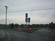
In the Malta Area, NY 67 enters as Dunning Street. Immediately before I-87
, there is a roundabout
at State Farm Road. A second roundabout shortly thereafter handles the southbound ramp traffic of I-87 exit 12, with a third roundabout handing northbound on the other side. A fourth roundabout handles an intersection with Malta Commons and Kelch Drive, and a fifth handles the intersection with US 9, beginning the overlap with US 9.
 After the final roundabout, NY 67 turns south, concurrent with US 9 for 1.5 miles (2.4 km), just north of the village of Round Lake
. Here, the route heads eastward, taking a winding path toward Mechanicville
and the Hudson River
. After entering the city, NY 67 becomes concurrent with US 4 and NY 32 for less than 0.1 mile (0.160934 km), then heads east toward Schaghticoke, crossing the Hudson on the Mechanicville Bridge
.
as Reservoir Road. Turning left and overlapping, the routes enter Schaghticoke upon crossing the Hoosic River
. Passing through the village, NY 67 splits right at the Schaghticoke Fairgrounds, where CR 125, an old routing of NY 67, enters from the left. NY 67 turns to cross the Hoosic River again in Valley Falls
, running south of the river through Buskirk and crossing again in Eagle Bridge
to briefly enter Washington County.
NY 67 meets NY 22
in White Creek
after 0.9 miles (1.4 km). Turning right, running concurrent for 0.6 mile (0.965604 km), the paired routes re-enter Rensselaer County. Once back in Rensselaer County, the routes split at Hoosick Junction
. Passing through farmland, NY 67 ends at the Vermont
state line, continuing as Vermont Route 67.
south of Galway
and the southern end of the overlap with NY 50
south of Ballston Spa was originally designated as part of two legislative route
s by the New York State Legislature in 1908. From Galway to Ballston Spa
, what is now NY 67 was part of Route 37. The modern overlap with NY 50 was part of Route 25. In 1912, Route 37 was realigned between Kimball Corners and Saratoga Springs
to use modern NY 29
. Its former routing between Kimball Corners and Ballston Spa via Galway was redesignated as Route 37-a. Also added in 1912 was Route 37-b, a spur route that ran from Route 25 south of Ballston Spa east to what is now U.S. Route 9 in Malta
via current NY 67. The Route 37-a and Route 37-b designations were eliminated on March 1, 1921.
When the first set of posted routes in New York were assigned in 1924, the section of modern NY 67 between Round Lake
and Mechanicville
was designated as part of NY 6. Most of NY 6, including the section from Round Lake to Malta, was renumbered to US 9 in 1927. In the 1930 renumbering of state highways in New York, US 9 was realigned onto its modern alignment between Albany
and Round Lake. Its former routing from Round Lake to Malta became part of the new NY 67, which extended west to NY 10
in Ephratah
and east to the Vermont
state line via Johnstown
, Amsterdam
, Ballston Spa, Stillwater
, and Hoosick
. From Galway to Malta, NY 67 utilized the former alignments of legislative Routes 25, 37-a and 37-b. Between Mechanicville and Schaghticoke, NY 67 initially ran concurrent with US 4 and NY 32
to Stillwater, where it turned east and followed what is now Rensselaer County Route 125 across the Hudson River
to NY 40
north of Schaghticoke.
On April 1, 1980, ownership and maintenance of NY 67 between the access road to lock 4 of the Champlain Canal
and NY 40 was transferred from the state of New York
to Rensselaer County
as part of a highway maintenance swap between the two levels of government. One highway transferred from the county to the state at this time was Old Schaghticoke Road, which extended from the county line at Mechanicville east to NY 40 just southwest of Schaghticoke. NY 67 was realigned to follow the new state highway between Mechanicville and Schaghticoke while the county-maintained portion of its former alignment became County Route 125. The short piece of NY 67's former routing between US 4 and NY 32 in Stillwater and the access road to Champlain Canal lock 4 remained state-maintained and became NY 915C, an unsigned reference route.
A second maintenance swap, this time between the state and Montgomery County
, occurred on April 1, 1981. As part of the swap, ownership and maintenance of New Turnpike Road (County Route 52) between NY 5
outside of St. Johnsville
and the Fulton County
line was transferred from Montgomery County to the state of New York. The new state highway became a westward extension of NY 67, which overlapped a section of NY 10 between Ephratah and NY 10's junction with New Turnpike Road. The 0.34 mile (0.5471756 km) section of New Turnpike Road between the Fulton County line and NY 10 was never transferred to the state and is still maintained by the town of Ephratah.
State highway
State highway, state road or state route can refer to one of three related concepts, two of them related to a state or provincial government in a country that is divided into states or provinces :#A...
in eastern New York
New York
New York is a state in the Northeastern region of the United States. It is the nation's third most populous state. New York is bordered by New Jersey and Pennsylvania to the south, and by Connecticut, Massachusetts and Vermont to the east...
in the United States
United States
The United States of America is a federal constitutional republic comprising fifty states and a federal district...
. The western terminus of the route is at an intersection with NY 5
New York State Route 5
New York State Route 5 is a state highway that extends for across the state of New York in the United States. It begins at the Pennsylvania state line in the Chautauqua County town of Ripley and passes through Buffalo, Syracuse, Utica, Schenectady, and several other smaller cities and...
in the town of St. Johnsville
St. Johnsville (town), New York
St. Johnsville is a town in Montgomery County, New York, United States. The population was 2,631 at the 2010 census. The town and its village are named after an early surveyor and commissioner, Alexander St. John....
. Its eastern terminus is at the Vermont
Vermont
Vermont is a state in the New England region of the northeastern United States of America. The state ranks 43rd in land area, , and 45th in total area. Its population according to the 2010 census, 630,337, is the second smallest in the country, larger only than Wyoming. It is the only New England...
state line in Hoosick
Hoosick, New York
Hoosick is a town in Rensselaer County, New York, United States. The population was 6,759 at the 2000 census.The Town of Hoosick is in the northeast corner of the county.- History :...
, where it continues eastward as Vermont Route 67.
Montgomery and Fulton Counties
NY 67 begins at an intersection with NY 5New York State Route 5
New York State Route 5 is a state highway that extends for across the state of New York in the United States. It begins at the Pennsylvania state line in the Chautauqua County town of Ripley and passes through Buffalo, Syracuse, Utica, Schenectady, and several other smaller cities and...
east of the village of St. Johnsville
St. Johnsville (village), New York
St. Johnsville is a village in Montgomery County, New York, United States. The population was 1,685 at the 2000 census. The name is derived from Alexander St. John, an early surveyor and commissioner....
in the town of the same name
St. Johnsville (town), New York
St. Johnsville is a town in Montgomery County, New York, United States. The population was 2,631 at the 2010 census. The town and its village are named after an early surveyor and commissioner, Alexander St. John....
. It heads eastward across northern Montgomery County
Montgomery County, New York
As of the census of 2000, there were 49,708 people, 20,038 households, and 13,104 families residing in the county. The population density was 123 people per square mile . There were 22,522 housing units at an average density of 56 per square mile...
as New Turnpike Road to the Fulton County
Fulton County, New York
Fulton County is a county located in the U.S. state of New York. As of the 2010 census, the population was 55,531. Its name is in honor of Robert Fulton, who is widely credited with developing the first commercially successful steamboat...
line, where maintenance of NY 67 shifts from the New York State Department of Transportation
New York State Department of Transportation
The New York State Department of Transportation is responsible for the development and operation of highways, railroads, mass transit systems, ports, waterways and aviation facilities in the U.S...
(NYSDOT) to the town of Ephratah
Ephratah, New York
Ephratah is a town in Fulton County, New York, United States. The population was 1,693 at the 2000 census. The name is from the Bible and means "fruitful."...
. Thus, the 0.34 mile (0.5471756 km) segment of New Turnpike Road between the county line and NY 10
New York State Route 10
New York State Route 10 is a north–south state highway in the Central New York and North Country regions of New York in the United States. It extends for from the Quickway in Deposit, Delaware County to NY 8 at Higgins Bay, a hamlet in the Hamilton County town of Arietta...
has no reference marker
Reference marker (New York)
In New York, a reference marker is a small green sign mounted approximately every one-tenth mile on highways maintained by the New York State Department of Transportation. This was initiated in response to the Highway Safety Act of 1966 enacted by Congress, in an effort to monitor traffic and...
s. This segment of the route also lacks any shoulders. At NY 10, maintenance of NY 67 returns to NYSDOT as it turns north to overlap NY 10 into the hamlet of Ephratah.
In Ephratah, NY 67 splits from NY 10 and heads east as a narrow and winding highway. It continues into the town of Johnstown
Johnstown (town), New York
Johnstown is a town located in Fulton County, New York, United States. As of the 2000 U.S. Census, the town had a population of 7,166. The name of the town is from landowner William Johnson....
, where it meets the eastern terminus of the aforementioned New Turnpike Road (an unimproved town road) at Eppie Corners and winds through hilly terrain through the hamlet of Keck's Center. It intersects the north end of NY 334
New York State Route 334
New York State Route 334 is a state highway in New York, running from the village of Fonda to the town of Johnstown. NY 334 is a two-lane highway its entire length, with the exception of a long climbing lane northbound leaving Sammonsville...
before passing into the city of Johnstown
Johnstown (city), New York
Johnstown is a city and the county seat of Fulton County in the U.S. state of New York. As of the 2000 Census, the city had population of 8,511. Recent estimates put the figure closer to 8,100. The city was named by its founder, Sir William Johnson after his son John Johnson...
. In the western part of the city, NY 67 follows West Main Street for several blocks to William Street, where it is joined by NY 29
New York State Route 29
New York State Route 29 is a state highway extending for across the eastern portion of the U.S. state of New York. The western terminus of the route is at NY 28 and NY 169 in Middleville, Herkimer County. The eastern terminus of the route is at NY 22 just south of Salem,...
. After crossing downtown, the overlap with NY 29 ends with NY 29 continuing straight (east) on East Main Street and NY 67 veering southeast onto East State Street. The route exits the city just southeast of a junction with NY 30A
New York State Route 30A
New York State Route 30A is a state highway in the Capital District of New York in the United States. It serves as a westerly alternate route of NY 30 from near the Schoharie County village of Schoharie to the Fulton County hamlet of Riceville, south of the village of Mayfield...
. NY 67 proceeds onward, passing the Fulton County Airport
Fulton County Airport (New York)
Fulton County Airport is a county-owned public-use airport in Fulton County, New York, United States. It is located two nautical miles east of the central business district of Johnstown...
, Hamilton-Fulton-Montgomery BOCES
Board of Cooperative Educational Services
In 1948, the New York State Legislature created the Boards of Cooperative Educational Services to provide school districts with a program of shared educational services.-History:...
, and Fulton-Montgomery Community College
Fulton-Montgomery Community College
Fulton-Montgomery Community College is a two-year college located in Johnstown, New York. The college is a part of the State University of New York and serves Fulton and Montgomery counties. The college offers 45 degree and certificate programs, 30 campus clubs, and is a member of the NJCAA,...
before reentering Montgomery County.
Second pass through Montgomery County
Once again in Montgomery County, NY 67 follows a winding, narrow path. One steep curve was eliminated in the early 2000s northwest of Fort JohnsonFort Johnson, New York
Fort Johnson, formerly known as Akin, is a village in Montgomery County, New York, United States. The population was 491 at the 2000 census.The Village of Fort Johnson is in the south part of the town of Amsterdam, west of the city of Amsterdam....
. In Fort Johnson, NY 67 joins NY 5 toward Amsterdam
Amsterdam (city), New York
Amsterdam is a city located in Montgomery County, New York, USA. As of the 2010 census, the city had a total population of 18,620. The name is derived from the city of Amsterdam in the Netherlands....
.
In Amsterdam, NY 67 enters with NY 5 as West Main Street. After passing an unusual flashing traffic light
Traffic light
Traffic lights, which may also be known as stoplights, traffic lamps, traffic signals, signal lights, robots or semaphore, are signalling devices positioned at road intersections, pedestrian crossings and other locations to control competing flows of traffic...
at Guy Park Manor
Guy Park
Guy Park, also known as Guy Park State Historic Site, is a house built in 1774 in the Georgian architectural style for Guy Johnson, nephew and son-in-law to Sir William Johnson, the British Superintendent for Indian Affairs in colonial New York...
, a four-lane highway begins parallel to Main Street. Historically, NY 67 and NY 5 followed Main Street through the city. With the 1977 creation of the Amsterdam Mall, NY 67 and NY 5, together with NY 30
New York State Route 30
New York State Route 30 is a state highway in the central part of New York in the United States. It extends for from an interchange with NY 17 in the Southern Tier to the Canadian border in the state's North Country, where it continues into Quebec as Route 138. On a regional level,...
, were re-routed onto splits comprising the Amsterdam Arterial. After a left exit for NY 30 southbound and a link to the Thruway
New York State Thruway
The New York State Thruway is a system of limited-access highways located within the state of New York in the United States. The system, known officially as the Governor Thomas E. Dewey Thruway for former New York Governor Thomas E. Dewey, is operated by the New York State Thruway Authority and...
, NY 67 follows underneath NY 30 southbound, then takes a left exit next to the mall. NY 67 then follows NY 30 North, crossing NY 5 westbound, then splitting off toward Ballston Spa
Ballston Spa, New York
Ballston Spa is a village in Saratoga County, New York, United States. The population was 5,556 at the 2000 census. It is the county seat of Saratoga County. The village is named after Rev. Eliphalet Ball, a Congregationalist clergyman and an early settler. The village lies on the border of two...
, passing through the hamlet of Manny Corners, south of the village of Hagaman
Hagaman, New York
Hagaman is a village in Montgomery County, New York, United States. The population was 1,357 at the 2000 census. It is named after Joseph Hagaman, the founding father....
.
Saratoga County
Galway, New York
Galway, New York may refer to:*Galway , New York*Galway , New York...
. In Ballston Spa
Ballston Spa, New York
Ballston Spa is a village in Saratoga County, New York, United States. The population was 5,556 at the 2000 census. It is the county seat of Saratoga County. The village is named after Rev. Eliphalet Ball, a Congregationalist clergyman and an early settler. The village lies on the border of two...
, NY 67 meets NY 50
New York State Route 50
New York State Route 50 is a state highway in the Capital District of New York in the United States. The southern terminus of the route is at an intersection with NY 5 in Scotia...
, turning south and overlapping for about a mile. NY 67 then splits off to the east, heading toward the Adirondack Northway at Malta
Malta, New York
Malta is a town in Saratoga County, New York, United States. The town is in the central part of the county and is south of Saratoga Springs. The population was 13,005 at the 2000 census.- History :The town was first settled before 1865....
.
In the Malta Area, NY 67 enters as Dunning Street. Immediately before I-87
Interstate 87
Interstate 87 is a Interstate Highway located entirely within New York State in the United States of America. I-87 is the longest intrastate Interstate highway in the Interstate Highway System. Its southern end is at the Bronx approaches of the Robert F. Kennedy Bridge in New York City...
, there is a roundabout
Roundabout
A roundabout is the name for a road junction in which traffic moves in one direction around a central island. The word dates from the early 20th century. Roundabouts are common in many countries around the world...
at State Farm Road. A second roundabout shortly thereafter handles the southbound ramp traffic of I-87 exit 12, with a third roundabout handing northbound on the other side. A fourth roundabout handles an intersection with Malta Commons and Kelch Drive, and a fifth handles the intersection with US 9, beginning the overlap with US 9.
Round Lake, New York
Round Lake is a lake and a village in Saratoga County, New York, United States. The population was 604 at the 2000 census. The name is derived from a circular lake adjacent to the village...
. Here, the route heads eastward, taking a winding path toward Mechanicville
Mechanicville, New York
Mechanicville is a city in Saratoga County, New York, United States. The population is 5,196 as of the 2010 census. It is the smallest city by area in the state. The name is derived from the occupations of early residents....
and the Hudson River
Hudson River
The Hudson is a river that flows from north to south through eastern New York. The highest official source is at Lake Tear of the Clouds, on the slopes of Mount Marcy in the Adirondack Mountains. The river itself officially begins in Henderson Lake in Newcomb, New York...
. After entering the city, NY 67 becomes concurrent with US 4 and NY 32 for less than 0.1 mile (0.160934 km), then heads east toward Schaghticoke, crossing the Hudson on the Mechanicville Bridge
Mechanicville Bridge
The Mechanicville Bridge carries New York State Route 67 across the Hudson River in New York connecting Mechanicville with Hemstreet Park in the Town of Schaghticoke. The bridge was built as a replacement for a privately built toll bridge, and is referred to by some as the Champlain Canal...
.
Rensselaer and Washington Counties
Old Schaghticoke Road carries NY 67 eastward and uphill, meeting NY 40New York State Route 40
New York State Route 40 is a north–south state highway in eastern New York, United States. It is long and runs from NY 7 in the city of Troy north to NY 22 in the town of Granville. NY 40 also passes through the villages of Schaghticoke and Argyle and enters the vicinity of...
as Reservoir Road. Turning left and overlapping, the routes enter Schaghticoke upon crossing the Hoosic River
Hoosic River
The Hoosic River, also known as the Hoosac, the Hoosick and the Hoosuck , is a tributary of the Hudson River in the northeastern United States. The different spellings are the result of varying transliterations of the river's original Algonquian name...
. Passing through the village, NY 67 splits right at the Schaghticoke Fairgrounds, where CR 125, an old routing of NY 67, enters from the left. NY 67 turns to cross the Hoosic River again in Valley Falls
Valley Falls, New York
Valley Falls is a village in Rensselaer County, New York, United States. The population was 491 at the 2000 census. The village lies on the boundary of the towns of Pittstown and Schaghticoke, but is mostly in the northwest part of Pittstown.- History :...
, running south of the river through Buskirk and crossing again in Eagle Bridge
Eagle Bridge, New York
Eagle Bridge is an unincorporated community in Rensselaer County, New York, United States. It was served by the Rutland and Washington Railroad.Eagle Bridge is also the name used by the United States Postal Service to identify ZIP code 12057...
to briefly enter Washington County.
NY 67 meets NY 22
New York State Route 22
New York State Route 22 is a north–south state highway in eastern New York in the United States. It runs parallel to the state's eastern edge from the outskirts of New York City to a short distance south of the Canadian border. At , it is the state's longest north–south route and...
in White Creek
White Creek, New York
White Creek is a town in Washington County, New York, United States. It is part of the Glens Falls Metropolitan Statistical Area. The town population was 3,411 at the 2000 census.-History:...
after 0.9 miles (1.4 km). Turning right, running concurrent for 0.6 mile (0.965604 km), the paired routes re-enter Rensselaer County. Once back in Rensselaer County, the routes split at Hoosick Junction
Hoosick, New York
Hoosick is a town in Rensselaer County, New York, United States. The population was 6,759 at the 2000 census.The Town of Hoosick is in the northeast corner of the county.- History :...
. Passing through farmland, NY 67 ends at the Vermont
Vermont
Vermont is a state in the New England region of the northeastern United States of America. The state ranks 43rd in land area, , and 45th in total area. Its population according to the 2010 census, 630,337, is the second smallest in the country, larger only than Wyoming. It is the only New England...
state line, continuing as Vermont Route 67.
History
The portion of modern NY 67 between what is now NY 147New York State Route 147
New York State Route 147 is a north–south state highway in the Capital District of New York, United States. The southern terminus of the route is at an intersection with NY 5 west of Schenectady in the village of Scotia. Its northern terminus is at a junction with NY 29 in the town...
south of Galway
Galway (village), New York
Galway is a village in the town of Galway in Saratoga County, New York, USA. The population was 214 at the 2000 census. The village is north of Schenectady. Galway Lake, a vacation area, is west of the village.- History :...
and the southern end of the overlap with NY 50
New York State Route 50
New York State Route 50 is a state highway in the Capital District of New York in the United States. The southern terminus of the route is at an intersection with NY 5 in Scotia...
south of Ballston Spa was originally designated as part of two legislative route
Legislative route
In United States, a legislative route or legislative highway is a highway defined by laws passed in a state legislature. The numbering of such highways may or may not correspond to the numbers familiar to the public as part of the state, U.S. highway, and Interstate highway systems...
s by the New York State Legislature in 1908. From Galway to Ballston Spa
Ballston Spa, New York
Ballston Spa is a village in Saratoga County, New York, United States. The population was 5,556 at the 2000 census. It is the county seat of Saratoga County. The village is named after Rev. Eliphalet Ball, a Congregationalist clergyman and an early settler. The village lies on the border of two...
, what is now NY 67 was part of Route 37. The modern overlap with NY 50 was part of Route 25. In 1912, Route 37 was realigned between Kimball Corners and Saratoga Springs
Saratoga Springs, New York
Saratoga Springs, also known as simply Saratoga, is a city in Saratoga County, New York, United States. The population was 26,586 at the 2010 census. The name reflects the presence of mineral springs in the area. While the word "Saratoga" is known to be a corruption of a Native American name, ...
to use modern NY 29
New York State Route 29
New York State Route 29 is a state highway extending for across the eastern portion of the U.S. state of New York. The western terminus of the route is at NY 28 and NY 169 in Middleville, Herkimer County. The eastern terminus of the route is at NY 22 just south of Salem,...
. Its former routing between Kimball Corners and Ballston Spa via Galway was redesignated as Route 37-a. Also added in 1912 was Route 37-b, a spur route that ran from Route 25 south of Ballston Spa east to what is now U.S. Route 9 in Malta
Malta, New York
Malta is a town in Saratoga County, New York, United States. The town is in the central part of the county and is south of Saratoga Springs. The population was 13,005 at the 2000 census.- History :The town was first settled before 1865....
via current NY 67. The Route 37-a and Route 37-b designations were eliminated on March 1, 1921.
When the first set of posted routes in New York were assigned in 1924, the section of modern NY 67 between Round Lake
Round Lake, New York
Round Lake is a lake and a village in Saratoga County, New York, United States. The population was 604 at the 2000 census. The name is derived from a circular lake adjacent to the village...
and Mechanicville
Mechanicville, New York
Mechanicville is a city in Saratoga County, New York, United States. The population is 5,196 as of the 2010 census. It is the smallest city by area in the state. The name is derived from the occupations of early residents....
was designated as part of NY 6. Most of NY 6, including the section from Round Lake to Malta, was renumbered to US 9 in 1927. In the 1930 renumbering of state highways in New York, US 9 was realigned onto its modern alignment between Albany
Albany, New York
Albany is the capital city of the U.S. state of New York, the seat of Albany County, and the central city of New York's Capital District. Roughly north of New York City, Albany sits on the west bank of the Hudson River, about south of its confluence with the Mohawk River...
and Round Lake. Its former routing from Round Lake to Malta became part of the new NY 67, which extended west to NY 10
New York State Route 10
New York State Route 10 is a north–south state highway in the Central New York and North Country regions of New York in the United States. It extends for from the Quickway in Deposit, Delaware County to NY 8 at Higgins Bay, a hamlet in the Hamilton County town of Arietta...
in Ephratah
Ephratah, New York
Ephratah is a town in Fulton County, New York, United States. The population was 1,693 at the 2000 census. The name is from the Bible and means "fruitful."...
and east to the Vermont
Vermont
Vermont is a state in the New England region of the northeastern United States of America. The state ranks 43rd in land area, , and 45th in total area. Its population according to the 2010 census, 630,337, is the second smallest in the country, larger only than Wyoming. It is the only New England...
state line via Johnstown
Johnstown (city), New York
Johnstown is a city and the county seat of Fulton County in the U.S. state of New York. As of the 2000 Census, the city had population of 8,511. Recent estimates put the figure closer to 8,100. The city was named by its founder, Sir William Johnson after his son John Johnson...
, Amsterdam
Amsterdam (city), New York
Amsterdam is a city located in Montgomery County, New York, USA. As of the 2010 census, the city had a total population of 18,620. The name is derived from the city of Amsterdam in the Netherlands....
, Ballston Spa, Stillwater
Stillwater (village), New York
Stillwater is a village in Saratoga County, New York, United States. The population was 1,644 at the 2000 census.The Village of Stillwater is in the southeast part of the Town of Stillwater, north of the City of Mechanicville.- History :...
, and Hoosick
Hoosick, New York
Hoosick is a town in Rensselaer County, New York, United States. The population was 6,759 at the 2000 census.The Town of Hoosick is in the northeast corner of the county.- History :...
. From Galway to Malta, NY 67 utilized the former alignments of legislative Routes 25, 37-a and 37-b. Between Mechanicville and Schaghticoke, NY 67 initially ran concurrent with US 4 and NY 32
New York State Route 32
New York State Route 32 is a north–south state highway that extends for through the Hudson Valley and Capital District regions of the U.S. state of New York. It is a two-lane surface road for nearly its entire length, with few divided and no limited-access sections. From Harriman to Albany,...
to Stillwater, where it turned east and followed what is now Rensselaer County Route 125 across the Hudson River
Hudson River
The Hudson is a river that flows from north to south through eastern New York. The highest official source is at Lake Tear of the Clouds, on the slopes of Mount Marcy in the Adirondack Mountains. The river itself officially begins in Henderson Lake in Newcomb, New York...
to NY 40
New York State Route 40
New York State Route 40 is a north–south state highway in eastern New York, United States. It is long and runs from NY 7 in the city of Troy north to NY 22 in the town of Granville. NY 40 also passes through the villages of Schaghticoke and Argyle and enters the vicinity of...
north of Schaghticoke.
On April 1, 1980, ownership and maintenance of NY 67 between the access road to lock 4 of the Champlain Canal
Champlain Canal
The Champlain Canal is a canal that connects the south end of Lake Champlain to the Hudson River in New York. It was simultaneously constructed with the Erie Canal and is now part of the New York State Canal System and the Lakes to Locks Passage....
and NY 40 was transferred from the state of New York
New York
New York is a state in the Northeastern region of the United States. It is the nation's third most populous state. New York is bordered by New Jersey and Pennsylvania to the south, and by Connecticut, Massachusetts and Vermont to the east...
to Rensselaer County
Rensselaer County, New York
Rensselaer County is a county in the U.S. state of New York. As of the 2010 census, the population was 159,429. Its name is in honor of the family of Kiliaen van Rensselaer, the original Dutch owner of the land in the area. Its county seat is Troy...
as part of a highway maintenance swap between the two levels of government. One highway transferred from the county to the state at this time was Old Schaghticoke Road, which extended from the county line at Mechanicville east to NY 40 just southwest of Schaghticoke. NY 67 was realigned to follow the new state highway between Mechanicville and Schaghticoke while the county-maintained portion of its former alignment became County Route 125. The short piece of NY 67's former routing between US 4 and NY 32 in Stillwater and the access road to Champlain Canal lock 4 remained state-maintained and became NY 915C, an unsigned reference route.
A second maintenance swap, this time between the state and Montgomery County
Montgomery County, New York
As of the census of 2000, there were 49,708 people, 20,038 households, and 13,104 families residing in the county. The population density was 123 people per square mile . There were 22,522 housing units at an average density of 56 per square mile...
, occurred on April 1, 1981. As part of the swap, ownership and maintenance of New Turnpike Road (County Route 52) between NY 5
New York State Route 5
New York State Route 5 is a state highway that extends for across the state of New York in the United States. It begins at the Pennsylvania state line in the Chautauqua County town of Ripley and passes through Buffalo, Syracuse, Utica, Schenectady, and several other smaller cities and...
outside of St. Johnsville
St. Johnsville (village), New York
St. Johnsville is a village in Montgomery County, New York, United States. The population was 1,685 at the 2000 census. The name is derived from Alexander St. John, an early surveyor and commissioner....
and the Fulton County
Fulton County, New York
Fulton County is a county located in the U.S. state of New York. As of the 2010 census, the population was 55,531. Its name is in honor of Robert Fulton, who is widely credited with developing the first commercially successful steamboat...
line was transferred from Montgomery County to the state of New York. The new state highway became a westward extension of NY 67, which overlapped a section of NY 10 between Ephratah and NY 10's junction with New Turnpike Road. The 0.34 mile (0.5471756 km) section of New Turnpike Road between the Fulton County line and NY 10 was never transferred to the state and is still maintained by the town of Ephratah.