
New York State Route 210
Encyclopedia
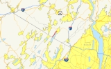
New York State Route 210 (NY 210) is a state highway
in Orange County, New York
, in the United States
. It runs north from the New Jersey
state line—where it continues south as Passaic County Route 511
(CR 511)—along the west shore of Greenwood Lake
to the eponymous village of Greenwood Lake
, where it ends at a junction with NY 17A
. It was once much longer, as it originally extended east along NY 17A and CR 106 in Orange
and Rockland
Counties to Stony Point
when it was assigned as part of the 1930 renumbering of state highways in New York. The route was truncated to its current length in 1982. Prior to becoming NY 210 in 1930, the road alongside Greenwood Lake was part of NY 55, a route connecting New Jersey to Goshen
, in the 1920s.
– New Jersey
state line in the town of Warwick, where it connects to CR 511
in Passaic County, New Jersey
. Like CR 511 in New Jersey, NY 210 is the primary lakeside roadway along Greenwood Lake
, an interstate lake located roughly equally in New Jersey and New York. NY 210 heads north from the state line along the western edge of the base of a deep valley surrounding the lake to a community known as Indian Park, entirely situated on the steep incline leading away from the lake. The route continues on to the eponymous village of Greenwood Lake
, located at the northern tip of the lake.
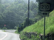
NY 210 enters the village center from the west on Jersey Avenue. It follows the village street for four blocks to Windermere Avenue, where it turns to follow that street to the northeast. The route terminates nine blocks later upon intersecting NY 17A
north of the village center.
. This 20 miles (32 km) extension was primarily made up of several highways that were previously part of a privately-maintained road. On March 10, 1824, the New York State Legislature passed a law incorporating the Monroe and Haverstraw Road Company. The new company was tasked with building a turnpike from the hamlet of Monroe (now Southfields) east to the town of Haverstraw
, where it ended at a fork in the road somewhere in the town. The turnpike company ceased to exist on April 28, 1870, when the legislature passed a law repealing the 1824 document that created the turnpike company. The highway was subsequently sold off in order to pay off the debts of the company and to finance repairs to bridges along the road.
When Harriman State Park opened in 1910, the Monroe–Haverstraw highway was renamed Southfields Road. Three years later, a portion of the route became part of Seven Lakes Drive
, a major highway built to traverse the park. In 1916, Rockland County numbered its highways for the first time. The Rockland County section of the former Monroe and Haverstraw Road was designated as CR 416 at this time. From 1919 to 1920, the highway was reconstructed and rebuilt to state standards.
in Goshen
and the New Jersey
state line south of the village of Greenwood Lake
. In the 1930 renumbering of state highways in New York, NY 55 was incorporated into two longer routes: NY 210 from New Jersey to Greenwood Lake and NY 17A
from Greenwood Lake to Goshen. Initially, NY 17A ended in Greenwood Lake while NY 210 continued east to U.S. Route 9W (US 9W) on the banks of the Hudson River
in West Haverstraw
. From Greenwood Lake to Southfields, NY 210 was routed on modern NY 17A. The route continued east from there along Southfields Road to the eastern fringe of Harriman State Park, at which point it headed to West Haverstraw via Willow Grove and Letchworth Village Roads, Suffern Lane, and Railroad Avenue.
By 1933, NY 17A was extended eastward along NY 210 to Southfields, completing the alternate loop of NY 17, while NY 210 was realigned on its east end by 1938 to end at US 9W in Stony Point
. Instead of following Willow Point Road, the highway remained on modern Gate Hill Road to the vicinity of Stony Point, where it entered the hamlet on Main Street. It was rerouted again between 1968 and 1973 to bypass Main Street to the south on Central Drive.
 On April 1, 1980, ownership and maintenance of the portion of NY 210 from NY 17 to the Orange–Rockland county line was transferred from the state of New York
to Orange County
as part of a highway maintenance swap between the two levels of government. Two years later, the portion of the route within Rockland County was turned over from the state to the county. As a result, NY 210 was truncated to the former western terminus of its overlap with NY 17A in Greenwood Lake. The former routing of NY 210 is now designated as CR 106 in both Orange
and Rockland
Counties.
. On July 15, 1940, a Brooklyn
couple was killed when their car struck a stone ledge near the lake. Two others were injured in the accident. On December 1, 1968, three were killed and one person was injured when two cars had a head-on collision just north of the New Jersey state line.
State highway
State highway, state road or state route can refer to one of three related concepts, two of them related to a state or provincial government in a country that is divided into states or provinces :#A...
in Orange County, New York
Orange County, New York
Orange County is a county located in the U.S. state of New York. It is part of the Poughkeepsie–Newburgh–Middletown, NY Metropolitan Statistical Area and is located at the northern reaches of the New York metropolitan area. The county sits in the state's scenic Mid-Hudson Region of the Hudson Valley...
, in the United States
United States
The United States of America is a federal constitutional republic comprising fifty states and a federal district...
. It runs north from the New Jersey
New Jersey
New Jersey is a state in the Northeastern and Middle Atlantic regions of the United States. , its population was 8,791,894. It is bordered on the north and east by the state of New York, on the southeast and south by the Atlantic Ocean, on the west by Pennsylvania and on the southwest by Delaware...
state line—where it continues south as Passaic County Route 511
County Route 511 (New Jersey)
County Route 511 is a county highway in the U.S. state of New Jersey. The highway extends 37.44 miles from Columbia Avenue in Morris Township to the New York state line in West Milford....
(CR 511)—along the west shore of Greenwood Lake
Greenwood Lake
Greenwood Lake is an interstate lake approximately seven miles long, straddling the border of New Jersey and New York. It is located in West Milford, New Jersey and Greenwood Lake, New York ....
to the eponymous village of Greenwood Lake
Greenwood Lake, New York
Greenwood Lake is a village in Orange County, New York, United States. As of the United States 2000 Census, the village population was 3,411. It is part of the Poughkeepsie–Newburgh–Middletown, NY Metropolitan Statistical Area as well as the larger New...
, where it ends at a junction with NY 17A
New York State Route 17A
New York State Route 17A is a state highway in southern New York, United States, entirely within Orange County. Its western terminus is located at Goshen at a junction with NY 17, and its eastern terminus is at another intersection with NY 17 located in Southfields. It runs...
. It was once much longer, as it originally extended east along NY 17A and CR 106 in Orange
County Route 106 (Orange County, New York)
County Route 106 in the county of Orange County, New York is a continuation of two routes, New York State Route 17A at its western terminus and Rockland CR 106 at the eastern terminus. Route 106 begins at an intersection with NY 17A and its parent route, NY 17 in...
and Rockland
County Route 106 (Rockland County, New York)
County Route 106 is the continuation of Orange County Route 106 in Rockland County, New York. The route is long and heads east–west through Harriman State Park. The route originated as New York State Route 210 and as County Highway 416 back in the 1920s and 1930s...
Counties to Stony Point
Stony Point, New York
Stony Point is a triangle-shaped town in Rockland County, United States. Rockland County is part of the New York Metropolitan Area. The town is located north of the town of Haverstraw, east and south of Orange County, New York, and west of the Hudson River and Westchester County. The population...
when it was assigned as part of the 1930 renumbering of state highways in New York. The route was truncated to its current length in 1982. Prior to becoming NY 210 in 1930, the road alongside Greenwood Lake was part of NY 55, a route connecting New Jersey to Goshen
Goshen (village), New York
Goshen is a village in and the county seat of Orange County, New York, United States. The population was 5,676 at the 2000 census. It is part of the Poughkeepsie–Newburgh–Middletown, NY Metropolitan Statistical Area as well as the larger New York–Newark–Bridgeport,...
, in the 1920s.
Route description
NY 210 commences at the New YorkNew York
New York is a state in the Northeastern region of the United States. It is the nation's third most populous state. New York is bordered by New Jersey and Pennsylvania to the south, and by Connecticut, Massachusetts and Vermont to the east...
– New Jersey
New Jersey
New Jersey is a state in the Northeastern and Middle Atlantic regions of the United States. , its population was 8,791,894. It is bordered on the north and east by the state of New York, on the southeast and south by the Atlantic Ocean, on the west by Pennsylvania and on the southwest by Delaware...
state line in the town of Warwick, where it connects to CR 511
County Route 511 (New Jersey)
County Route 511 is a county highway in the U.S. state of New Jersey. The highway extends 37.44 miles from Columbia Avenue in Morris Township to the New York state line in West Milford....
in Passaic County, New Jersey
Passaic County, New Jersey
Passaic County is a county located in the U.S. state of New Jersey. As of the 2010 Census, the population was 501,226. Its county seat is Paterson...
. Like CR 511 in New Jersey, NY 210 is the primary lakeside roadway along Greenwood Lake
Greenwood Lake
Greenwood Lake is an interstate lake approximately seven miles long, straddling the border of New Jersey and New York. It is located in West Milford, New Jersey and Greenwood Lake, New York ....
, an interstate lake located roughly equally in New Jersey and New York. NY 210 heads north from the state line along the western edge of the base of a deep valley surrounding the lake to a community known as Indian Park, entirely situated on the steep incline leading away from the lake. The route continues on to the eponymous village of Greenwood Lake
Greenwood Lake, New York
Greenwood Lake is a village in Orange County, New York, United States. As of the United States 2000 Census, the village population was 3,411. It is part of the Poughkeepsie–Newburgh–Middletown, NY Metropolitan Statistical Area as well as the larger New...
, located at the northern tip of the lake.
NY 210 enters the village center from the west on Jersey Avenue. It follows the village street for four blocks to Windermere Avenue, where it turns to follow that street to the northeast. The route terminates nine blocks later upon intersecting NY 17A
New York State Route 17A
New York State Route 17A is a state highway in southern New York, United States, entirely within Orange County. Its western terminus is located at Goshen at a junction with NY 17, and its eastern terminus is at another intersection with NY 17 located in Southfields. It runs...
north of the village center.
Old roads
From 1930 to 1982, NY 210 extended eastward into Rockland CountyRockland County, New York
Rockland County is a suburban county 15 miles to the northwest of Manhattan and part of the New York City Metropolitan Area, in the U.S. state of New York. It is the southernmost county in New York west of the Hudson River, and the smallest county in New York outside of New York City. The...
. This 20 miles (32 km) extension was primarily made up of several highways that were previously part of a privately-maintained road. On March 10, 1824, the New York State Legislature passed a law incorporating the Monroe and Haverstraw Road Company. The new company was tasked with building a turnpike from the hamlet of Monroe (now Southfields) east to the town of Haverstraw
Haverstraw (town), New York
Haverstraw is a town in Rockland County, New York, United States located north of the Town of Clarkstown and the Town of Ramapo; east of Orange County, New York; south of the Town of Stony Point and west of the Hudson River. The town runs from the west to the east border of the county in its...
, where it ended at a fork in the road somewhere in the town. The turnpike company ceased to exist on April 28, 1870, when the legislature passed a law repealing the 1824 document that created the turnpike company. The highway was subsequently sold off in order to pay off the debts of the company and to finance repairs to bridges along the road.
When Harriman State Park opened in 1910, the Monroe–Haverstraw highway was renamed Southfields Road. Three years later, a portion of the route became part of Seven Lakes Drive
Seven Lakes Drive
Seven Lakes Drive is a 17.91 mile long parkway in the U.S. state of New York. The southern terminus of the route is at New York State Route 17 in Sloatsburg. The northern terminus is at U.S. Route 9W and U.S. Route 202 a mile south of Fort Montgomery in Bear Mountain State Park...
, a major highway built to traverse the park. In 1916, Rockland County numbered its highways for the first time. The Rockland County section of the former Monroe and Haverstraw Road was designated as CR 416 at this time. From 1919 to 1920, the highway was reconstructed and rebuilt to state standards.
Designation
In the late 1920s, what is now NY 210 was originally designated as part of NY 55, a connector between NY 17New York State Route 17
New York State Route 17 is a state highway that extends for through the Southern Tier and Downstate regions of New York in the United States...
in Goshen
Goshen (village), New York
Goshen is a village in and the county seat of Orange County, New York, United States. The population was 5,676 at the 2000 census. It is part of the Poughkeepsie–Newburgh–Middletown, NY Metropolitan Statistical Area as well as the larger New York–Newark–Bridgeport,...
and the New Jersey
New Jersey
New Jersey is a state in the Northeastern and Middle Atlantic regions of the United States. , its population was 8,791,894. It is bordered on the north and east by the state of New York, on the southeast and south by the Atlantic Ocean, on the west by Pennsylvania and on the southwest by Delaware...
state line south of the village of Greenwood Lake
Greenwood Lake, New York
Greenwood Lake is a village in Orange County, New York, United States. As of the United States 2000 Census, the village population was 3,411. It is part of the Poughkeepsie–Newburgh–Middletown, NY Metropolitan Statistical Area as well as the larger New...
. In the 1930 renumbering of state highways in New York, NY 55 was incorporated into two longer routes: NY 210 from New Jersey to Greenwood Lake and NY 17A
New York State Route 17A
New York State Route 17A is a state highway in southern New York, United States, entirely within Orange County. Its western terminus is located at Goshen at a junction with NY 17, and its eastern terminus is at another intersection with NY 17 located in Southfields. It runs...
from Greenwood Lake to Goshen. Initially, NY 17A ended in Greenwood Lake while NY 210 continued east to U.S. Route 9W (US 9W) on the banks of the Hudson River
Hudson River
The Hudson is a river that flows from north to south through eastern New York. The highest official source is at Lake Tear of the Clouds, on the slopes of Mount Marcy in the Adirondack Mountains. The river itself officially begins in Henderson Lake in Newcomb, New York...
in West Haverstraw
West Haverstraw, New York
West Haverstraw is a village in the Town of Haverstraw Rockland County, New York, United States located northwest of the Village of Haverstraw; east of Thiells; south of the Hamlet of Stony Point and west of the Hudson River. The population was 10,295 at the 2000 census...
. From Greenwood Lake to Southfields, NY 210 was routed on modern NY 17A. The route continued east from there along Southfields Road to the eastern fringe of Harriman State Park, at which point it headed to West Haverstraw via Willow Grove and Letchworth Village Roads, Suffern Lane, and Railroad Avenue.
By 1933, NY 17A was extended eastward along NY 210 to Southfields, completing the alternate loop of NY 17, while NY 210 was realigned on its east end by 1938 to end at US 9W in Stony Point
Stony Point, New York
Stony Point is a triangle-shaped town in Rockland County, United States. Rockland County is part of the New York Metropolitan Area. The town is located north of the town of Haverstraw, east and south of Orange County, New York, and west of the Hudson River and Westchester County. The population...
. Instead of following Willow Point Road, the highway remained on modern Gate Hill Road to the vicinity of Stony Point, where it entered the hamlet on Main Street. It was rerouted again between 1968 and 1973 to bypass Main Street to the south on Central Drive.
New York
New York is a state in the Northeastern region of the United States. It is the nation's third most populous state. New York is bordered by New Jersey and Pennsylvania to the south, and by Connecticut, Massachusetts and Vermont to the east...
to Orange County
Orange County, New York
Orange County is a county located in the U.S. state of New York. It is part of the Poughkeepsie–Newburgh–Middletown, NY Metropolitan Statistical Area and is located at the northern reaches of the New York metropolitan area. The county sits in the state's scenic Mid-Hudson Region of the Hudson Valley...
as part of a highway maintenance swap between the two levels of government. Two years later, the portion of the route within Rockland County was turned over from the state to the county. As a result, NY 210 was truncated to the former western terminus of its overlap with NY 17A in Greenwood Lake. The former routing of NY 210 is now designated as CR 106 in both Orange
County Route 106 (Orange County, New York)
County Route 106 in the county of Orange County, New York is a continuation of two routes, New York State Route 17A at its western terminus and Rockland CR 106 at the eastern terminus. Route 106 begins at an intersection with NY 17A and its parent route, NY 17 in...
and Rockland
County Route 106 (Rockland County, New York)
County Route 106 is the continuation of Orange County Route 106 in Rockland County, New York. The route is long and heads east–west through Harriman State Park. The route originated as New York State Route 210 and as County Highway 416 back in the 1920s and 1930s...
Counties.
Accidents
Over the years, at least two fatal accidents have occurred on the portion of NY 210 that runs alongside Greenwood LakeGreenwood Lake
Greenwood Lake is an interstate lake approximately seven miles long, straddling the border of New Jersey and New York. It is located in West Milford, New Jersey and Greenwood Lake, New York ....
. On July 15, 1940, a Brooklyn
Brooklyn
Brooklyn is the most populous of New York City's five boroughs, with nearly 2.6 million residents, and the second-largest in area. Since 1896, Brooklyn has had the same boundaries as Kings County, which is now the most populous county in New York State and the second-most densely populated...
couple was killed when their car struck a stone ledge near the lake. Two others were injured in the accident. On December 1, 1968, three were killed and one person was injured when two cars had a head-on collision just north of the New Jersey state line.