
.gif)
County Route 106 (Rockland County, New York)
Encyclopedia
County Route 106 is the continuation of Orange County Route 106 in Rockland County, New York
. The route is 7.8 miles (12.6 km) long and heads east–west through Harriman State Park. The route originated as New York State Route 210 and as County Highway 416 back in the 1920s and 1930s. In 1982, NY 210 was decertified and replaced by CR 106 in Orange
and Rockland Counties
. CR 106 intersects with several county highways in Rockland County along the way. There are also many intersections with trails in Harriman State Park.
CR 106 is only one of two routes in Rockland County to keep its numbering from Orange County, with the other being County Route 72
. CR 106 had one spur route, CR 106A, which was recently decommissioned.
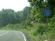
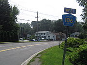 CR 106 runs through Harriman State Park into Stony Point. CR 106 begins at the Orange County line in Harriman State Park as a continuation of Orange County Route 106
, and ends at US 9W/US 202 in Stony Point. Orange County Route 106 has a junction with Seven Lakes Drive
just after the Rockland County line. The route proceeds through the state park before ending at NY 17
and NY 17A
. CR 106 is only one of two county routes that are shared by Rockland and Orange County. The other is CR 72
.
 Rockland CR 106 begins right after Orange CR 106's traffic circle with Seven Lakes Drive
near Lake Kanawauke
. CR 106 proceeds east from here providing a border between Harriman State Park (to the west) and Bear Mountain State Park
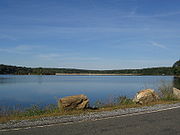
(to the east). It then intersects Lake Welch Parkway, a seasonal road which provides a route to Lake Welch Beach on the northern side of the lake. Then, CR 106 splits Lake Welch in two different locations on the southern side of the lake. CR 106 then begins its trek out of Harriman State Park and into the town of Stony Point.
 Immediately after entering Stony Point, CR 106 intersects CR 98 where CR 106 makes a left turn. CR 106 then proceeds east toward its intersection with the Palisades Parkway
. This is at Exit 15 and is the last residential exit northbound on the PIP, with everything north of this point being exits within Harriman and Bear Mountain.
Just after its intersection with the PIP, the road intersects two former Rockland County Routes (CR 106A & CR 69). Also, at this point CR 106 enters the village limits of Stony Point, and becomes a 55 mi/h, highway with extra lanes in some places. The highway intersects CR 108, CR 47, and CR 33
as Central Drive. CR 106 comes to an end shortly after these intersections at US 9W/US 202 in downtown Stony Point, about a mile west from the Hudson River
and the Stony Point Marina.
 CR 106 originated in 1824, when the road was chartered for the New Turnpike and headed from Monroe
to Haverstraw. Back in the 1820s, what is now Southfields was known as Monroe. The New Turnpike started at a nail factory in Monroe to a crossing over the Ramapo River
, and progressed eastward, passing Lake Stahahe (then known as Car Pond). The turnpike continued eastward, meeting the Old Turnpike at a fork in the road. At the fork, part of the road became NY 210 in the 1930 New York State Route renumbering
. In 1910, when the park opened, the road became known as the Southfields Road. Three years later, it became part of the Seven Lakes Drive
. Three more years later, the route became known as County Highway 416. In 1919 and 1920, the western section of the road was reconstructed. After a bridge was built to cross a river in 1923, a new route, making up part of the original Warwick Turnpike, became NY 17A
.
The responsibility for maintaining NY 210 was turned over the county in 1982. The road was replaced with CR 106.
Rockland County, New York
Rockland County is a suburban county 15 miles to the northwest of Manhattan and part of the New York City Metropolitan Area, in the U.S. state of New York. It is the southernmost county in New York west of the Hudson River, and the smallest county in New York outside of New York City. The...
. The route is 7.8 miles (12.6 km) long and heads east–west through Harriman State Park. The route originated as New York State Route 210 and as County Highway 416 back in the 1920s and 1930s. In 1982, NY 210 was decertified and replaced by CR 106 in Orange
Orange County, New York
Orange County is a county located in the U.S. state of New York. It is part of the Poughkeepsie–Newburgh–Middletown, NY Metropolitan Statistical Area and is located at the northern reaches of the New York metropolitan area. The county sits in the state's scenic Mid-Hudson Region of the Hudson Valley...
and Rockland Counties
Rockland County, New York
Rockland County is a suburban county 15 miles to the northwest of Manhattan and part of the New York City Metropolitan Area, in the U.S. state of New York. It is the southernmost county in New York west of the Hudson River, and the smallest county in New York outside of New York City. The...
. CR 106 intersects with several county highways in Rockland County along the way. There are also many intersections with trails in Harriman State Park.
CR 106 is only one of two routes in Rockland County to keep its numbering from Orange County, with the other being County Route 72
County Route 72 (Rockland County, New York)
County Route 72 is a west–east county-maintained highway in the western part of Rockland County, New York, in the United States. CR 72 begins at the Orange County line in Sloatsburg and Eagle Valley, and ends at NY 17 . It runs exclusively through Sloatsburg, and is the only...
. CR 106 had one spur route, CR 106A, which was recently decommissioned.
Route description
County Route 106 (Orange County, New York)
County Route 106 in the county of Orange County, New York is a continuation of two routes, New York State Route 17A at its western terminus and Rockland CR 106 at the eastern terminus. Route 106 begins at an intersection with NY 17A and its parent route, NY 17 in...
, and ends at US 9W/US 202 in Stony Point. Orange County Route 106 has a junction with Seven Lakes Drive
Seven Lakes Drive
Seven Lakes Drive is a 17.91 mile long parkway in the U.S. state of New York. The southern terminus of the route is at New York State Route 17 in Sloatsburg. The northern terminus is at U.S. Route 9W and U.S. Route 202 a mile south of Fort Montgomery in Bear Mountain State Park...
just after the Rockland County line. The route proceeds through the state park before ending at NY 17
New York State Route 17
New York State Route 17 is a state highway that extends for through the Southern Tier and Downstate regions of New York in the United States...
and NY 17A
New York State Route 17A
New York State Route 17A is a state highway in southern New York, United States, entirely within Orange County. Its western terminus is located at Goshen at a junction with NY 17, and its eastern terminus is at another intersection with NY 17 located in Southfields. It runs...
. CR 106 is only one of two county routes that are shared by Rockland and Orange County. The other is CR 72
County Route 72 (Rockland County, New York)
County Route 72 is a west–east county-maintained highway in the western part of Rockland County, New York, in the United States. CR 72 begins at the Orange County line in Sloatsburg and Eagle Valley, and ends at NY 17 . It runs exclusively through Sloatsburg, and is the only...
.
Seven Lakes Drive
Seven Lakes Drive is a 17.91 mile long parkway in the U.S. state of New York. The southern terminus of the route is at New York State Route 17 in Sloatsburg. The northern terminus is at U.S. Route 9W and U.S. Route 202 a mile south of Fort Montgomery in Bear Mountain State Park...
near Lake Kanawauke
Lake Kanawauke
Lake Kanawauke is a primarily man-made lake in Harriman State Park. The name is Onondaga in origin, and means "place of much water". There are three parts to the lake, lower, middle and upper; the total area is...
. CR 106 proceeds east from here providing a border between Harriman State Park (to the west) and Bear Mountain State Park
Bear Mountain State Park
Bear Mountain State Park is located on the west side of the Hudson River in Orange and Rockland counties of New York. The park offers biking, hiking, boating, picnicking, swimming, cross-country skiing, cross-country running, sledding and ice skating...
(to the east). It then intersects Lake Welch Parkway, a seasonal road which provides a route to Lake Welch Beach on the northern side of the lake. Then, CR 106 splits Lake Welch in two different locations on the southern side of the lake. CR 106 then begins its trek out of Harriman State Park and into the town of Stony Point.
Palisades Interstate Parkway
The Palisades Interstate Parkway is a long limited-access highway in the U.S. states of New Jersey and New York. The parkway is a major commuter route into New York City from Rockland and Orange counties in New York and Bergen County in New Jersey...
. This is at Exit 15 and is the last residential exit northbound on the PIP, with everything north of this point being exits within Harriman and Bear Mountain.
Just after its intersection with the PIP, the road intersects two former Rockland County Routes (CR 106A & CR 69). Also, at this point CR 106 enters the village limits of Stony Point, and becomes a 55 mi/h, highway with extra lanes in some places. The highway intersects CR 108, CR 47, and CR 33
County Route 33 (Rockland County, New York)
County Route 33 is a south–north county route in the central part of Rockland County, New York. Prior to 1970, portions of CR 33 were designated as the old route of New York State Route 304. Today, CR 33 serves as an alternative route for NY 304 from Pearl River to New City...
as Central Drive. CR 106 comes to an end shortly after these intersections at US 9W/US 202 in downtown Stony Point, about a mile west from the Hudson River
Hudson River
The Hudson is a river that flows from north to south through eastern New York. The highest official source is at Lake Tear of the Clouds, on the slopes of Mount Marcy in the Adirondack Mountains. The river itself officially begins in Henderson Lake in Newcomb, New York...
and the Stony Point Marina.
History
Monroe, New York
Monroe, New York may refer to two municipalities in Orange County, New York in the United States:*Monroe , New York*Monroe , New York, located entirely within the town...
to Haverstraw. Back in the 1820s, what is now Southfields was known as Monroe. The New Turnpike started at a nail factory in Monroe to a crossing over the Ramapo River
Ramapo River
The Ramapo River is a tributary of the Pompton River, approximately 30 mi long, in southern New York and northern New Jersey in the United States.-Course:...
, and progressed eastward, passing Lake Stahahe (then known as Car Pond). The turnpike continued eastward, meeting the Old Turnpike at a fork in the road. At the fork, part of the road became NY 210 in the 1930 New York State Route renumbering
1930 New York State Route renumbering
In January 1930, the U.S. state of New York implemented a major renumbering of its state highways. Many previously existing numbered routes were renumbered or realigned. At the same time, many state highways that were previously unnumbered received designations...
. In 1910, when the park opened, the road became known as the Southfields Road. Three years later, it became part of the Seven Lakes Drive
Seven Lakes Drive
Seven Lakes Drive is a 17.91 mile long parkway in the U.S. state of New York. The southern terminus of the route is at New York State Route 17 in Sloatsburg. The northern terminus is at U.S. Route 9W and U.S. Route 202 a mile south of Fort Montgomery in Bear Mountain State Park...
. Three more years later, the route became known as County Highway 416. In 1919 and 1920, the western section of the road was reconstructed. After a bridge was built to cross a river in 1923, a new route, making up part of the original Warwick Turnpike, became NY 17A
New York State Route 17A
New York State Route 17A is a state highway in southern New York, United States, entirely within Orange County. Its western terminus is located at Goshen at a junction with NY 17, and its eastern terminus is at another intersection with NY 17 located in Southfields. It runs...
.
The responsibility for maintaining NY 210 was turned over the county in 1982. The road was replaced with CR 106.
CR 106A
- CR 106A - Route 106A was a 0.1 mile (0.160934 km) spur which began at CR 106, ending at a dead end just before reaching CR 69 in Stony Point.
Major intersections
See also
- List of county routes in Rockland County, New York (76–118A)
- County Route 106 (Orange County, New York)