

New York State Route 17A
Encyclopedia
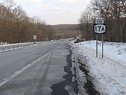
New York State Route 17A (NY 17A) is a state highway in southern New York
, United States
, entirely within Orange County
. Its western terminus is located at Goshen
at a junction with NY 17
, and its eastern terminus is at another intersection with NY 17 located in Southfields. It runs concurrently with NY 94
from Warwick
to Florida
. It serves mainly to connect Warwick with the rest of the county. While it is an east–west route, many sections run in a more north–south orientation. Its circuitous route allows it to offer much scenery to drivers.
The Greenwood Lake
– Goshen portion of NY 17A was originally designated as part of New York State Route 55 in the 1920s. South of Greenwood Lake, NY 55 used modern NY 210
. NY 55 was split into NY 17A and NY 210 as part of the 1930 renumbering of state highways in New York. Initially, only NY 210 continued east from Greenwood Lake to Southfields; however, NY 17A was extended to Southfields by 1933, overlapping NY 210. The overlap was eliminated in 1982 when NY 210 was truncated to Greenwood Lake.
. At the traffic light
with the southern on-ramp from NY 17 eastbound, NY 207 becomes NY 17A. The route quickly climbs to some of the hillier areas south of Goshen, offering views of not only Orange County's Black Dirt Region but Pochuck Mountain
and High Point
to the south in New Jersey
. It then slowly descends past rolling meadows and farmland until it reaches the small village of Florida
, where NY 94 comes in from the west shortly after the village border. The concurrent
roads then become Florida's main street.
Once out of the village, NY 17A and NY 94 begin to climb again, this time offering some panoramic views to the north, all the way to the Shawangunk Ridge
and even the Catskill Mountains
beyond them in clear enough weather. The road is surprisingly little developed in this area, with only one gas station between Florida and Warwick
, its next stop, which likewise presents itself after a descent. Again, NY 17A and NY 94 serve as the bustling village's main street, longer this time and with many upscale boutiques in evidence. Many historic buildings
line the road through Warwick. Near the southern end of the village, the two roads split, with Route 94 continuing toward New Jersey while NY 17A goes eastward.
The road begins to climb again over the next few miles, passing a county park and finally the small Mount Peter ski area before crossing the Appalachian Trail
along the ridgecrest of Bellvale Mountain. From here it once again drops down and bends in a north–south direction to reach Greenwood Lake
, where NY 210 leaves to go along the side of the lake to the state line.
 Leaving Greenwood Lake, NY 17A climbs once again to cross another ridge before descending and expanding to a four-lane with median strip to pass through Sterling Forest and reach its eastern terminus at NY 17 in Southfields. The highway continues as County Route 106 (CR 106) in Orange and Rockland Counties east to that route's eastern terminus at US 9W
and US 202 in Stony Point
. CR 106 was once part of NY 210
before it was truncated to NY 17A in Greenwood Lake
.
to Goshen
was designated as part of NY 55, a connector between NY 17
in Goshen and the New Jersey
state line. In the 1930 renumbering of state highways in New York, NY 55 was incorporated into two longer routes: NY 210
from New Jersey to Greenwood Lake and NY 17A from Greenwood Lake to Goshen. The modern routing of NY 17A between Greenfield Lake and Southfields was originally only part of NY 210, which continued past NY 17 and into Rockland County
. NY 17A was extended east to Southfields by 1933, completing the alternate loop of NY 17 and creating an overlap with NY 210.
In 1980, ownership and maintenance of NY 210 between NY 210 and the Rockland County line was transferred from the state of New York
to Orange County
. Two years later, all of NY 210 in Rockland County was given to the county. NY 210 was truncated to its current northern terminus in Greenwood Lake following the latter swap, eliminating the overlap with NY 17A.
New York
New York is a state in the Northeastern region of the United States. It is the nation's third most populous state. New York is bordered by New Jersey and Pennsylvania to the south, and by Connecticut, Massachusetts and Vermont to the east...
, United States
United States
The United States of America is a federal constitutional republic comprising fifty states and a federal district...
, entirely within Orange County
Orange County, New York
Orange County is a county located in the U.S. state of New York. It is part of the Poughkeepsie–Newburgh–Middletown, NY Metropolitan Statistical Area and is located at the northern reaches of the New York metropolitan area. The county sits in the state's scenic Mid-Hudson Region of the Hudson Valley...
. Its western terminus is located at Goshen
Goshen (village), New York
Goshen is a village in and the county seat of Orange County, New York, United States. The population was 5,676 at the 2000 census. It is part of the Poughkeepsie–Newburgh–Middletown, NY Metropolitan Statistical Area as well as the larger New York–Newark–Bridgeport,...
at a junction with NY 17
New York State Route 17
New York State Route 17 is a state highway that extends for through the Southern Tier and Downstate regions of New York in the United States...
, and its eastern terminus is at another intersection with NY 17 located in Southfields. It runs concurrently with NY 94
New York State Route 94
New York State Route 94 is a state highway entirely within Orange County in southern New York. The western terminus is at the New York-New Jersey state line, where it continues as NJ 94 for another to Columbia, New Jersey. Its eastern terminus is located at U.S. Route 9W in New Windsor....
from Warwick
Warwick, New York
Warwick is a town in Orange County, New York, United States. The population was 30,764 at the 2000 census. The 2007 census population estimate is 32,669.The Town of Warwick is located in the southwest part of the county...
to Florida
Florida, Orange County, New York
Florida is a village in Orange County, New York, United States. The population was 2,757 at the 2007 census estimates. It is part of the Poughkeepsie–Newburgh–Middletown, NY Metropolitan Statistical Area as well as the larger New York–Newark–Bridgeport, NY-NJ-CT-PA Combined...
. It serves mainly to connect Warwick with the rest of the county. While it is an east–west route, many sections run in a more north–south orientation. Its circuitous route allows it to offer much scenery to drivers.
The Greenwood Lake
Greenwood Lake, New York
Greenwood Lake is a village in Orange County, New York, United States. As of the United States 2000 Census, the village population was 3,411. It is part of the Poughkeepsie–Newburgh–Middletown, NY Metropolitan Statistical Area as well as the larger New...
– Goshen portion of NY 17A was originally designated as part of New York State Route 55 in the 1920s. South of Greenwood Lake, NY 55 used modern NY 210
New York State Route 210
New York State Route 210 is a state highway in Orange County, New York, in the United States. It runs north from the New Jersey state line—where it continues south as Passaic County Route 511 —along the west shore of Greenwood Lake to the eponymous village of Greenwood Lake, where it...
. NY 55 was split into NY 17A and NY 210 as part of the 1930 renumbering of state highways in New York. Initially, only NY 210 continued east from Greenwood Lake to Southfields; however, NY 17A was extended to Southfields by 1933, overlapping NY 210. The overlap was eliminated in 1982 when NY 210 was truncated to Greenwood Lake.
Route description
NY 17A begins just south of Route 17 exit 124 in GoshenGoshen (village), New York
Goshen is a village in and the county seat of Orange County, New York, United States. The population was 5,676 at the 2000 census. It is part of the Poughkeepsie–Newburgh–Middletown, NY Metropolitan Statistical Area as well as the larger New York–Newark–Bridgeport,...
. At the traffic light
Traffic light
Traffic lights, which may also be known as stoplights, traffic lamps, traffic signals, signal lights, robots or semaphore, are signalling devices positioned at road intersections, pedestrian crossings and other locations to control competing flows of traffic...
with the southern on-ramp from NY 17 eastbound, NY 207 becomes NY 17A. The route quickly climbs to some of the hillier areas south of Goshen, offering views of not only Orange County's Black Dirt Region but Pochuck Mountain
Pochuck Mountain
Pochuck Mountain is a ridge in the New York-New Jersey Highlands region of the Appalachian Mountains. Pochuck Mountain's summit and most of its peaks lie within Vernon Township, Sussex County, New Jersey, although the south-western portion of the ridge lies within Hardyston Township, and the...
and High Point
High Point
High Point, in the northwestern part of New Jersey in Montague, Sussex County in the Skylands Region of New Jersey, is the highest elevation in the state at 1,803 feet . It is southeast of Port Jervis, New York. High Point is the highest peak of the Kittatinny Mountains.At the peak is the High...
to the south in New Jersey
New Jersey
New Jersey is a state in the Northeastern and Middle Atlantic regions of the United States. , its population was 8,791,894. It is bordered on the north and east by the state of New York, on the southeast and south by the Atlantic Ocean, on the west by Pennsylvania and on the southwest by Delaware...
. It then slowly descends past rolling meadows and farmland until it reaches the small village of Florida
Florida, Orange County, New York
Florida is a village in Orange County, New York, United States. The population was 2,757 at the 2007 census estimates. It is part of the Poughkeepsie–Newburgh–Middletown, NY Metropolitan Statistical Area as well as the larger New York–Newark–Bridgeport, NY-NJ-CT-PA Combined...
, where NY 94 comes in from the west shortly after the village border. The concurrent
Concurrency (road)
A concurrency, overlap, or coincidence in a road network is an instance of one physical road bearing two or more different highway, motorway, or other route numbers...
roads then become Florida's main street.
Once out of the village, NY 17A and NY 94 begin to climb again, this time offering some panoramic views to the north, all the way to the Shawangunk Ridge
Shawangunk Ridge
The Shawangunk Ridge , also known as the Shawangunk Mountains or The Gunks, is a ridge of bedrock in Ulster County, Sullivan County and Orange County in the state of New York, extending from the northernmost point of New Jersey to the Catskill Mountains.The ridgetop, which widens considerably at...
and even the Catskill Mountains
Catskill Mountains
The Catskill Mountains, an area in New York State northwest of New York City and southwest of Albany, are a mature dissected plateau, an uplifted region that was subsequently eroded into sharp relief. They are an eastward continuation, and the highest representation, of the Allegheny Plateau...
beyond them in clear enough weather. The road is surprisingly little developed in this area, with only one gas station between Florida and Warwick
Warwick, New York
Warwick is a town in Orange County, New York, United States. The population was 30,764 at the 2000 census. The 2007 census population estimate is 32,669.The Town of Warwick is located in the southwest part of the county...
, its next stop, which likewise presents itself after a descent. Again, NY 17A and NY 94 serve as the bustling village's main street, longer this time and with many upscale boutiques in evidence. Many historic buildings
Warwick Village Historic District
The Warwick Village Historic District is located in the center of the village of Warwick in the U.S. state of New York. It takes up an irregularly-shaped 130 acres of residential and commercial neighborhoods centered around NY 94 and 17A)....
line the road through Warwick. Near the southern end of the village, the two roads split, with Route 94 continuing toward New Jersey while NY 17A goes eastward.
The road begins to climb again over the next few miles, passing a county park and finally the small Mount Peter ski area before crossing the Appalachian Trail
Appalachian Trail
The Appalachian National Scenic Trail, generally known as the Appalachian Trail or simply the AT, is a marked hiking trail in the eastern United States extending between Springer Mountain in Georgia and Mount Katahdin in Maine. It is approximately long...
along the ridgecrest of Bellvale Mountain. From here it once again drops down and bends in a north–south direction to reach Greenwood Lake
Greenwood Lake, New York
Greenwood Lake is a village in Orange County, New York, United States. As of the United States 2000 Census, the village population was 3,411. It is part of the Poughkeepsie–Newburgh–Middletown, NY Metropolitan Statistical Area as well as the larger New...
, where NY 210 leaves to go along the side of the lake to the state line.
U.S. Route 9W
U.S. Route 9W is a north–south U.S. Highway in the states of New Jersey and New York. It begins on Fletcher Avenue in Fort Lee, New Jersey as it crosses the US 1 & 9, US 46, and the Interstate 95 approaches to the George Washington Bridge, where it heads north up the west...
and US 202 in Stony Point
Stony Point, New York
Stony Point is a triangle-shaped town in Rockland County, United States. Rockland County is part of the New York Metropolitan Area. The town is located north of the town of Haverstraw, east and south of Orange County, New York, and west of the Hudson River and Westchester County. The population...
. CR 106 was once part of NY 210
New York State Route 210
New York State Route 210 is a state highway in Orange County, New York, in the United States. It runs north from the New Jersey state line—where it continues south as Passaic County Route 511 —along the west shore of Greenwood Lake to the eponymous village of Greenwood Lake, where it...
before it was truncated to NY 17A in Greenwood Lake
Greenwood Lake, New York
Greenwood Lake is a village in Orange County, New York, United States. As of the United States 2000 Census, the village population was 3,411. It is part of the Poughkeepsie–Newburgh–Middletown, NY Metropolitan Statistical Area as well as the larger New...
.
History
In the late 1920s, what is now NY 17A from Greenwood LakeGreenwood Lake, New York
Greenwood Lake is a village in Orange County, New York, United States. As of the United States 2000 Census, the village population was 3,411. It is part of the Poughkeepsie–Newburgh–Middletown, NY Metropolitan Statistical Area as well as the larger New...
to Goshen
Goshen (village), New York
Goshen is a village in and the county seat of Orange County, New York, United States. The population was 5,676 at the 2000 census. It is part of the Poughkeepsie–Newburgh–Middletown, NY Metropolitan Statistical Area as well as the larger New York–Newark–Bridgeport,...
was designated as part of NY 55, a connector between NY 17
New York State Route 17
New York State Route 17 is a state highway that extends for through the Southern Tier and Downstate regions of New York in the United States...
in Goshen and the New Jersey
New Jersey
New Jersey is a state in the Northeastern and Middle Atlantic regions of the United States. , its population was 8,791,894. It is bordered on the north and east by the state of New York, on the southeast and south by the Atlantic Ocean, on the west by Pennsylvania and on the southwest by Delaware...
state line. In the 1930 renumbering of state highways in New York, NY 55 was incorporated into two longer routes: NY 210
New York State Route 210
New York State Route 210 is a state highway in Orange County, New York, in the United States. It runs north from the New Jersey state line—where it continues south as Passaic County Route 511 —along the west shore of Greenwood Lake to the eponymous village of Greenwood Lake, where it...
from New Jersey to Greenwood Lake and NY 17A from Greenwood Lake to Goshen. The modern routing of NY 17A between Greenfield Lake and Southfields was originally only part of NY 210, which continued past NY 17 and into Rockland County
Rockland County, New York
Rockland County is a suburban county 15 miles to the northwest of Manhattan and part of the New York City Metropolitan Area, in the U.S. state of New York. It is the southernmost county in New York west of the Hudson River, and the smallest county in New York outside of New York City. The...
. NY 17A was extended east to Southfields by 1933, completing the alternate loop of NY 17 and creating an overlap with NY 210.
In 1980, ownership and maintenance of NY 210 between NY 210 and the Rockland County line was transferred from the state of New York
New York
New York is a state in the Northeastern region of the United States. It is the nation's third most populous state. New York is bordered by New Jersey and Pennsylvania to the south, and by Connecticut, Massachusetts and Vermont to the east...
to Orange County
Orange County, New York
Orange County is a county located in the U.S. state of New York. It is part of the Poughkeepsie–Newburgh–Middletown, NY Metropolitan Statistical Area and is located at the northern reaches of the New York metropolitan area. The county sits in the state's scenic Mid-Hudson Region of the Hudson Valley...
. Two years later, all of NY 210 in Rockland County was given to the county. NY 210 was truncated to its current northern terminus in Greenwood Lake following the latter swap, eliminating the overlap with NY 17A.