
.gif)
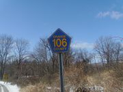
County Route 106 (Orange County, New York)
Encyclopedia
County Route 106 in the county of Orange County, New York
is a continuation of two routes, New York State Route 17A (NY 17A) at its western terminus and Rockland CR 106
at the eastern terminus. Route 106 begins at an intersection with NY 17A and its parent route, NY 17
in Southfields. The route heads eastward through Harriman State Park, crossing Seven Lakes Drive
before entering nearby Rockland County, New York
. There it becomes Rockland County Route 106 and heads all the way to Stony Point
.
Route 106 was originally a part of NY 210
. When Route 210 was assigned in the 1930 New York State Route renumbering
, it stretched from the New Jersey
border in Greenwood Lake
, over the current alignments of NY 17A, Orange CR 106 and Rockland CR 106, all the way to Stony Point. During a maintenance swap in 1980, Route 210 was truncated all the way back to NY 17A north of Greenwood Lake, and the route was replaced by both County Route 106s.
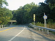
Much of Route 106 is mountainous, with peaks reaching as high as 1200 feet (365.8 m). The road is also very scenic, passing many hiking trails in Harriman State Park as well as several lakes. Route 106 is only one of two routes in Orange County to retain their Rockland County designation when crossing the border. The other is County Route 72 northeast of Sloatsburg
.
 Route 106 begins at an interchange with NY 17
(the Orange Turnpike) and NY 17A
(the Warwick Turnpike) in the hamlet of Southfields. Route 106 heads eastward, crossing over the Ramapo River
and passing below the New York State Thruway
before entering the mountainous regions of Harriman State Park. The highway heads into Harriman as Lake Kanawauke Road, passing to the south of Green Pond Mountain, a peak in Harriman that also contains part of the Appalachian Trail
.
Much of the route heads in different directions, with constant curves. Route 106 heads south of Lake Stahahe, a large lake in Harriman, curving around the base of a mountain. After leaving the lake and mountain behind, Route 106 makes several drastic turns, one to the north and one to the south. After another curve, this time to the east, Route 106 passes to the north of Tom Jones Mountain, the highest peak along the highway. Soon after, the road parallels the shore of Little Long Pond.
Route 106 crosses Lake Kanawauke after leaving the shore of Little Long Pond. Soon afterwards, the highway intersects with Seven Lakes Drive
at a roundabout. Just after the roundabout, Route 106 crosses the county border into Rockland County.
. When the park opened in 1910, Route 106 was known as Southfields Road. In 1913, it became part of Seven Lakes Drive, with another designation coming three years later as County Highway 416. During the period of 1919 and 1920, the road was reconstructed, with a bridge being built three years later. A new route was assigned that year making up the old Warwick Turnpike as NY 17A
.
 Route 210 was assigned over the current CR 106 alignment in the 1930 New York State Route renumbering
. The route then stretched from County Route 511
south of Greenwood Lake
, all the way up to NY 17A, where the two routes became concurrent. At the interchange for NY 17
, Route 17A ended, with 210 continuing eastward into Harriman. Route 210 headed eastward, into Rockland County, ending in Stony Point. During the maintenance swaps between the state of New York
and various counties in 1980, Route 210 was truncated to the part between CR 511 to the Route 17 interchange. The route was replaced by County Route 106 in both Rockland and Orange Counties.
) reported that the construction to fix the safety concerns near Little Long Pond would cost $300,000 (2009 USD). The construction report said the probable finish date for the project is December 1, 2009. The construction was, in fact, completed in December 2009 which also included the reconstruction of a second culvert connecting the northern and southern portions of Lake Kanawauke, located approximately 1/2 mile east of the failed culvert.
Orange County, New York
Orange County is a county located in the U.S. state of New York. It is part of the Poughkeepsie–Newburgh–Middletown, NY Metropolitan Statistical Area and is located at the northern reaches of the New York metropolitan area. The county sits in the state's scenic Mid-Hudson Region of the Hudson Valley...
is a continuation of two routes, New York State Route 17A (NY 17A) at its western terminus and Rockland CR 106
County Route 106 (Rockland County, New York)
County Route 106 is the continuation of Orange County Route 106 in Rockland County, New York. The route is long and heads east–west through Harriman State Park. The route originated as New York State Route 210 and as County Highway 416 back in the 1920s and 1930s...
at the eastern terminus. Route 106 begins at an intersection with NY 17A and its parent route, NY 17
New York State Route 17
New York State Route 17 is a state highway that extends for through the Southern Tier and Downstate regions of New York in the United States...
in Southfields. The route heads eastward through Harriman State Park, crossing Seven Lakes Drive
Seven Lakes Drive
Seven Lakes Drive is a 17.91 mile long parkway in the U.S. state of New York. The southern terminus of the route is at New York State Route 17 in Sloatsburg. The northern terminus is at U.S. Route 9W and U.S. Route 202 a mile south of Fort Montgomery in Bear Mountain State Park...
before entering nearby Rockland County, New York
Rockland County, New York
Rockland County is a suburban county 15 miles to the northwest of Manhattan and part of the New York City Metropolitan Area, in the U.S. state of New York. It is the southernmost county in New York west of the Hudson River, and the smallest county in New York outside of New York City. The...
. There it becomes Rockland County Route 106 and heads all the way to Stony Point
Stony Point, New York
Stony Point is a triangle-shaped town in Rockland County, United States. Rockland County is part of the New York Metropolitan Area. The town is located north of the town of Haverstraw, east and south of Orange County, New York, and west of the Hudson River and Westchester County. The population...
.
Route 106 was originally a part of NY 210
New York State Route 210
New York State Route 210 is a state highway in Orange County, New York, in the United States. It runs north from the New Jersey state line—where it continues south as Passaic County Route 511 —along the west shore of Greenwood Lake to the eponymous village of Greenwood Lake, where it...
. When Route 210 was assigned in the 1930 New York State Route renumbering
1930 New York State Route renumbering
In January 1930, the U.S. state of New York implemented a major renumbering of its state highways. Many previously existing numbered routes were renumbered or realigned. At the same time, many state highways that were previously unnumbered received designations...
, it stretched from the New Jersey
New Jersey
New Jersey is a state in the Northeastern and Middle Atlantic regions of the United States. , its population was 8,791,894. It is bordered on the north and east by the state of New York, on the southeast and south by the Atlantic Ocean, on the west by Pennsylvania and on the southwest by Delaware...
border in Greenwood Lake
Greenwood Lake, New York
Greenwood Lake is a village in Orange County, New York, United States. As of the United States 2000 Census, the village population was 3,411. It is part of the Poughkeepsie–Newburgh–Middletown, NY Metropolitan Statistical Area as well as the larger New...
, over the current alignments of NY 17A, Orange CR 106 and Rockland CR 106, all the way to Stony Point. During a maintenance swap in 1980, Route 210 was truncated all the way back to NY 17A north of Greenwood Lake, and the route was replaced by both County Route 106s.
Much of Route 106 is mountainous, with peaks reaching as high as 1200 feet (365.8 m). The road is also very scenic, passing many hiking trails in Harriman State Park as well as several lakes. Route 106 is only one of two routes in Orange County to retain their Rockland County designation when crossing the border. The other is County Route 72 northeast of Sloatsburg
Sloatsburg, New York
Sloatsburg is a village in the town of Ramapo in Rockland County, New York, United States. It is located east of Orange County, New York and sits at the southern entrance to Harriman State Park. The population was 3,117 at the 2000 census...
.
Route description
New York State Route 17
New York State Route 17 is a state highway that extends for through the Southern Tier and Downstate regions of New York in the United States...
(the Orange Turnpike) and NY 17A
New York State Route 17A
New York State Route 17A is a state highway in southern New York, United States, entirely within Orange County. Its western terminus is located at Goshen at a junction with NY 17, and its eastern terminus is at another intersection with NY 17 located in Southfields. It runs...
(the Warwick Turnpike) in the hamlet of Southfields. Route 106 heads eastward, crossing over the Ramapo River
Ramapo River
The Ramapo River is a tributary of the Pompton River, approximately 30 mi long, in southern New York and northern New Jersey in the United States.-Course:...
and passing below the New York State Thruway
New York State Thruway
The New York State Thruway is a system of limited-access highways located within the state of New York in the United States. The system, known officially as the Governor Thomas E. Dewey Thruway for former New York Governor Thomas E. Dewey, is operated by the New York State Thruway Authority and...
before entering the mountainous regions of Harriman State Park. The highway heads into Harriman as Lake Kanawauke Road, passing to the south of Green Pond Mountain, a peak in Harriman that also contains part of the Appalachian Trail
Appalachian Trail
The Appalachian National Scenic Trail, generally known as the Appalachian Trail or simply the AT, is a marked hiking trail in the eastern United States extending between Springer Mountain in Georgia and Mount Katahdin in Maine. It is approximately long...
.
Much of the route heads in different directions, with constant curves. Route 106 heads south of Lake Stahahe, a large lake in Harriman, curving around the base of a mountain. After leaving the lake and mountain behind, Route 106 makes several drastic turns, one to the north and one to the south. After another curve, this time to the east, Route 106 passes to the north of Tom Jones Mountain, the highest peak along the highway. Soon after, the road parallels the shore of Little Long Pond.
Route 106 crosses Lake Kanawauke after leaving the shore of Little Long Pond. Soon afterwards, the highway intersects with Seven Lakes Drive
Seven Lakes Drive
Seven Lakes Drive is a 17.91 mile long parkway in the U.S. state of New York. The southern terminus of the route is at New York State Route 17 in Sloatsburg. The northern terminus is at U.S. Route 9W and U.S. Route 202 a mile south of Fort Montgomery in Bear Mountain State Park...
at a roundabout. Just after the roundabout, Route 106 crosses the county border into Rockland County.
Historic turnpikes
The highway that would later become part of CR 106 originated in 1824. That is when the road was chartered as the New Turnpike, which stretched from what is now Southfields (formerly known as Monroe) to a fork in the road, which part later became NY 210New York State Route 210
New York State Route 210 is a state highway in Orange County, New York, in the United States. It runs north from the New Jersey state line—where it continues south as Passaic County Route 511 —along the west shore of Greenwood Lake to the eponymous village of Greenwood Lake, where it...
. When the park opened in 1910, Route 106 was known as Southfields Road. In 1913, it became part of Seven Lakes Drive, with another designation coming three years later as County Highway 416. During the period of 1919 and 1920, the road was reconstructed, with a bridge being built three years later. A new route was assigned that year making up the old Warwick Turnpike as NY 17A
New York State Route 17A
New York State Route 17A is a state highway in southern New York, United States, entirely within Orange County. Its western terminus is located at Goshen at a junction with NY 17, and its eastern terminus is at another intersection with NY 17 located in Southfields. It runs...
.
NY 210
1930 New York State Route renumbering
In January 1930, the U.S. state of New York implemented a major renumbering of its state highways. Many previously existing numbered routes were renumbered or realigned. At the same time, many state highways that were previously unnumbered received designations...
. The route then stretched from County Route 511
County Route 511 (New Jersey)
County Route 511 is a county highway in the U.S. state of New Jersey. The highway extends 37.44 miles from Columbia Avenue in Morris Township to the New York state line in West Milford....
south of Greenwood Lake
Greenwood Lake, New York
Greenwood Lake is a village in Orange County, New York, United States. As of the United States 2000 Census, the village population was 3,411. It is part of the Poughkeepsie–Newburgh–Middletown, NY Metropolitan Statistical Area as well as the larger New...
, all the way up to NY 17A, where the two routes became concurrent. At the interchange for NY 17
New York State Route 17
New York State Route 17 is a state highway that extends for through the Southern Tier and Downstate regions of New York in the United States...
, Route 17A ended, with 210 continuing eastward into Harriman. Route 210 headed eastward, into Rockland County, ending in Stony Point. During the maintenance swaps between the state of New York
New York
New York is a state in the Northeastern region of the United States. It is the nation's third most populous state. New York is bordered by New Jersey and Pennsylvania to the south, and by Connecticut, Massachusetts and Vermont to the east...
and various counties in 1980, Route 210 was truncated to the part between CR 511 to the Route 17 interchange. The route was replaced by County Route 106 in both Rockland and Orange Counties.
2008 culvert failure
Route 106 near Little Long Pond was closed in March 2008 due to the failure of a culvert between Little Long Pond and Lake Kanawauke. Route 106 was closed off in the area, with the rest of the road open for hikers. However, the road was not going to be connected again until summer of 2008. People are also allowed to walk in the area. Although the projected date of the summer of 2008 passed, the Palisades Interstate Park Commission and Orange County Department of Highways did not open the highway. On April 3, 2009, over one year since the closing of the highway, the Commission, Department of Highways (in conjunction with the New York State Department of TransportationNew York State Department of Transportation
The New York State Department of Transportation is responsible for the development and operation of highways, railroads, mass transit systems, ports, waterways and aviation facilities in the U.S...
) reported that the construction to fix the safety concerns near Little Long Pond would cost $300,000 (2009 USD). The construction report said the probable finish date for the project is December 1, 2009. The construction was, in fact, completed in December 2009 which also included the reconstruction of a second culvert connecting the northern and southern portions of Lake Kanawauke, located approximately 1/2 mile east of the failed culvert.