
New York State Route 17K
Encyclopedia
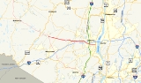
New York State Route 17K (NY 17K) is an east–west state highway
located within Orange County, New York
, in the United States. It extends for 22.37 miles (36 km) from an intersection with County Route 76 (CR 76) east of Bloomingburg
to a junction with U.S. Route 9W (US 9W) midway across the city of Newburgh
. The western terminus was where NY 17K originally connected to its parent route, NY 17
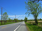
; it now meets NY 17 a short distance to the east at an interchange with the Quickway. In Newburgh, NY 17K becomes Broadway and serves as the city's primary east–west street. The road can be divided into a half west of Montgomery
, where it runs through relatively undeveloped land, and an eastern half where it closely parallels Interstate 84
(I-84) and serves much more populated areas.
The route follows the path of the Newburgh and Cochecton Turnpike
, a 19th century toll road
extending from Newburgh to Cochecton
. Most of the turnpike was taken over by the state of New York in the early 20th century, and the part east of Montgomery became the northernmost section of NY 8 in 1924. In the 1930 renumbering of state highways in New York, this segment of NY 8 became the basis for New York State Route 215, a new route that continued west from Montgomery to Bloomingburg. NY 215 was redesignated as NY 17K ca. 1939.
. The junction is just east of the Orange–Sullivan
county line, marked by a bridge carrying old NY 17 over the Shawangunk Kill
and into the center of Bloomingburg
. From there, NY 17K meets the modern NY 17 at an interchange with the Quickway before heading roughly eastward into the town of Crawford
. It going up and down some gentle hills to the first traffic light
, the six-way intersection with NY 302
(also the Long Path
hiking trail) that serves as downtown Bullville
. The direction of the highway remains unchanged as it continues past several horse farms and Winding Hills Park
on its way to the town of Montgomery
.
 Shortly after crossing the flood-prone Muddy Kill
, it reaches Ward's Bridge
, where it crosses the Wallkill River
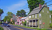
and enters the village of Montgomery
on Bridge Street, where it immediately passes the historic homes that line the street. The portion within the village is rather short, although consequential enough to include the traffic light at the northern end of NY 211
(Union Street). For the next two blocks, to Wallkill Avenue, the highway marks the northern boundary of Montgomery's other federally-designated historic district
, Academy Hill
. Just before the village's eastern boundary, it passes between two more Registered Historic Places
, the Patchett House
and Montgomery Water Works
.
After the village, it passes the combined building of Valley Central High School
and Valley Central Middle School
. The growing population of the area has added more traffic to the highway in recent years, forcing the school board to increase the stagger between the two schools' schedule, and hiring a police officer to direct traffic at the entrance. About 1 miles (1.6 km) to the east lies Scotts Corners, NY 17K's intersection with NY 208
. Just past the intersection, the headquarters of Walden Federal bank sit atop a hill on the north side of the road. Shortly afterward, Berea Elementary School
adds its traffic to the nearby intersection.
 Past the elementary school, NY 17K runs parallel to the nearby I-84
but remains undeveloped, with the odd house, store or side street breaking the woods. Much of the land here is owned by the county as part of its Farmers' Museum, which surrounds the Nathaniel Hill Brick House
, an early settler's home still occupied by his descendants. The next signalized intersection, Coldenham Road, provides a direct route to Walden
for traffic coming from the east. NY 17K continues on toward its next light, situated at the junction with NY 747
, a north–south route connecting NY 17K to I-84 and Stewart International Airport
.
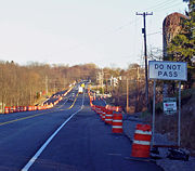
. While most of the county road was upgraded on the spot, the part of NY 747 closest to NY 17K was built on a new alignment to the west to avoid possible damage to the Catskill Aqueduct
, which crosses NY 17K here. This created a four-way intersection with Stone Castle Road, which was itself slightly relocated to the west as part of the plan to protect the adjacent Colden Mansion Ruins
. Not far to the east of this junction is the lone piece of Drury Lane not included in the new route, which now ends in a cul-de-sac
but still carries the CR 54 designation south of NY 17K.
 After Drury Lane, NY 17K passes the last building of the Valley Central School District
, East Coldenham Elementary School. In November 1989, nine students died here when a wall collapsed during a freak tornado
. Development along the highway begins to increase at this point as NY 17K directly intersects I-84 and runs along the northern boundary of Stewart Airport. The Newburgh Auto Auction's vast parking lots are visible to the north while commercial hangar
s and the local Air National Guard
base can be seen to the south. The base's entrance road, secured with a series of concrete barriers since the September 11, 2001 attacks, marks the end of the airport property.
The route continues on, passing south of the Orange County Choppers
's headquarters just before it crosses over the New York State Thruway
(I-87
). East of the Thruway, NY 17K widens to four lanes with a middle turn lane and becomes heavily developed as it reaches the busy intersection with the Newburgh area's main commercial strip, NY 300
. Actual access to the Thruway is no longer possible from NY 17K; instead, motorists must proceed north on NY 300 for approximately 0.5 mile (0.80467 km), at which point access to both I-87 and I-84 is provided. A short distance past the intersection with NY 300 is the former entrance ramp to the Thruway, which was utilized from 1955 until late 2009. Originally, the state planned to eradicate this entrance/exit ramp altogether, but changed their minds at the last minute when it was determined the overpass over Route 300 was in exceptionally good condition. Now, the ramp is open only to E-ZPass
holders exiting the Thruway.
The four-lane section continues through the town of Newburgh
to the Newburgh city
limit, where it narrows to two lanes and maintenance of the route switches from the New York State Department of Transportation
(NYSDOT) to the city of Newburgh. The route follows Broadway past several primarily residential blocks before meeting the eastern terminus of NY 207
at Wisner Avenue. Further on, NY 32
comes in from the south as Lake Street. The two form the only concurrency
along NY 17K as they overlap for several more blocks to the US 9W
junction at Robinson Avenue in a commercial section of Newburgh. Here, NY 17K ends while NY 32 turns north to join US 9W.
 Modern NY 17K follows the easternmost part of the Newburgh and Cochecton Turnpike
, a 19th century toll road
that extended from the Delaware River
at Cochecton
to the Hudson River
at Newburgh
. The turnpike was opened in 1810 and dissolved in 1872 following the establishment of the nearby Middletown and Crawford Railroad one year earlier. Stone markers indicating the distance from Newburgh can still be seen by the roadside at several locations. In the early 20th century, the state of New York
took over the turnpike's former routing from Fosterdale east to Newburgh to rebuild the highway as a toll-free state road. The segment from Bloomingburg
to Newburgh was added to the state highway system in stages, beginning on September 9, 1902, with the section between Montgomery
and what is now the New York State Thruway
overpass near Newburgh. The Bloomingburg–Newburgh state highway was entirely state-maintained by 1926.
When the first set of posted routes in New York were assigned in 1924, the portion of the highway between Montgomery and Newburgh became part of NY 8, a route that went from the New Jersey
state line at Unionville to Newburgh via Middletown
. The designation proved to be short-lived, however, as it was eliminated as part of the 1930 renumbering of state highways in New York. From the New Jersey line to Montgomery, NY 8 became NY 84. The remainder of old NY 8 became part of NY 215, a new route that continued west to Bloomingburg over the previously unnumbered state highway linking the two locations. Like the first NY 8, NY 215 was short-lived as it was redesignated as NY 17K ca. 1939. At one time, NY 17K extended eastward into downtown Newburgh to serve the now-defunct ferry
linking Newburgh to Beacon
.
State highway
State highway, state road or state route can refer to one of three related concepts, two of them related to a state or provincial government in a country that is divided into states or provinces :#A...
located within Orange County, New York
Orange County, New York
Orange County is a county located in the U.S. state of New York. It is part of the Poughkeepsie–Newburgh–Middletown, NY Metropolitan Statistical Area and is located at the northern reaches of the New York metropolitan area. The county sits in the state's scenic Mid-Hudson Region of the Hudson Valley...
, in the United States. It extends for 22.37 miles (36 km) from an intersection with County Route 76 (CR 76) east of Bloomingburg
Bloomingburg, New York
Bloomingburg, previously Bloomingburgh, is a village in Sullivan County, New York, United States. The population was 353 at the 2000 census.The Village of Bloomingburg is in the Town of Mamakating.- History :...
to a junction with U.S. Route 9W (US 9W) midway across the city of Newburgh
Newburgh (city), New York
Newburgh is a city located in Orange County, New York, United States, north of New York City, and south of Albany, on the Hudson River. Newburgh is a principal city of the Poughkeepsie-Newburgh-Middletown metropolitan area, which includes all of Dutchess and Orange counties. The Newburgh area was...
. The western terminus was where NY 17K originally connected to its parent route, NY 17
New York State Route 17
New York State Route 17 is a state highway that extends for through the Southern Tier and Downstate regions of New York in the United States...
; it now meets NY 17 a short distance to the east at an interchange with the Quickway. In Newburgh, NY 17K becomes Broadway and serves as the city's primary east–west street. The road can be divided into a half west of Montgomery
Montgomery (village), New York
Montgomery is a village located in Orange County, New York, United States, 60 miles northwest of New York City, and 90 miles southwest of Albany. The population was 3,636 at the 2000 census...
, where it runs through relatively undeveloped land, and an eastern half where it closely parallels Interstate 84
Interstate 84 (east)
Interstate 84 is an Interstate Highway extending from Dunmore, Pennsylvania at an interchange with Interstate 81 to Sturbridge, Massachusetts, at an interchange with the Massachusetts Turnpike . I-84 has mile-log junction numbering in Pennsylvania; otherwise, exit numbers are roughly sequential...
(I-84) and serves much more populated areas.
The route follows the path of the Newburgh and Cochecton Turnpike
Newburgh and Cochecton Turnpike
The Newburgh and Cochecton Turnpike was a turnpike road in southern New York in the United States. It ran from Newburgh on the Hudson River west to Cochecton on the Delaware River, where travelers could continue west through Pennsylvania on the Cochecton and Great Bend Turnpike toward Binghamton....
, a 19th century toll road
Toll road
A toll road is a privately or publicly built road for which a driver pays a toll for use. Structures for which tolls are charged include toll bridges and toll tunnels. Non-toll roads are financed using other sources of revenue, most typically fuel tax or general tax funds...
extending from Newburgh to Cochecton
Cochecton, New York
Cochecton is a town located in west-central Sullivan County, New York, USA. The population was 1,328 at the 2000 census. The name is an aboriginal word for "low land."...
. Most of the turnpike was taken over by the state of New York in the early 20th century, and the part east of Montgomery became the northernmost section of NY 8 in 1924. In the 1930 renumbering of state highways in New York, this segment of NY 8 became the basis for New York State Route 215, a new route that continued west from Montgomery to Bloomingburg. NY 215 was redesignated as NY 17K ca. 1939.
West of Newburgh
NY 17K's western terminus is at an intersection with CR 76 (the old, two-lane alignment of NY 17 through the area) in the town of WallkillWallkill, Orange County, New York
Wallkill is a town in Orange County, New York, United States. The population was 24,659 at the 2000 census.The Town of Wallkill is centrally located in the county. Interstate 84 crosses New York State Route 17 in the southern part of the town. U.S...
. The junction is just east of the Orange–Sullivan
Sullivan County, New York
Sullivan County is a county located in the U.S. state of New York. As of the 2010 census, the population was 77,547. The county seat is Monticello. The name is in honor of Major General John Sullivan, who was a hero in the American Revolutionary War...
county line, marked by a bridge carrying old NY 17 over the Shawangunk Kill
Shawangunk Kill
The Shawangunk Kill is a stream that flows northward through Orange, Sullivan and Ulster counties, New York, in the United States. It is the largest tributary of the Wallkill River....
and into the center of Bloomingburg
Bloomingburg, New York
Bloomingburg, previously Bloomingburgh, is a village in Sullivan County, New York, United States. The population was 353 at the 2000 census.The Village of Bloomingburg is in the Town of Mamakating.- History :...
. From there, NY 17K meets the modern NY 17 at an interchange with the Quickway before heading roughly eastward into the town of Crawford
Crawford, New York
Crawford is a town in Orange County, New York, USA. The population was 7,875 at the 2000 census. The name comes a settler who gave his name to a community in the town now called Pine Bush....
. It going up and down some gentle hills to the first traffic light
Traffic light
Traffic lights, which may also be known as stoplights, traffic lamps, traffic signals, signal lights, robots or semaphore, are signalling devices positioned at road intersections, pedestrian crossings and other locations to control competing flows of traffic...
, the six-way intersection with NY 302
New York State Route 302
New York State Route 302 is a state highway in northern Orange County, New York, United States. The southern terminus of the route is at an intersection with NY 17M north of the city of Middletown...
(also the Long Path
Long Path
The Long Path is a long-distance hiking trail beginning at the George Washington Bridge in Fort Lee, New Jersey and currently ending at Altamont, New York, in the Albany area...
hiking trail) that serves as downtown Bullville
Bullville, New York
Bullville, New York is a hamlet in the Town of Crawford in Orange County, New York, USA. It is located at the junction of routes NY-17K and NY-302.Bullville was one of the original four important settlements in the Town of Crawford....
. The direction of the highway remains unchanged as it continues past several horse farms and Winding Hills Park
Winding Hills Park
Winding Hills Park is located off NY 17K in the Comfort Hills two miles west of the village of Montgomery, New York, United States, straddling the Montgomery-Crawford town line. It is a area centered around Diamond Lake that is primarily used for outdoor recreation.Much of the park is wooded,...
on its way to the town of Montgomery
Montgomery (town), New York
Montgomery is a town in Orange County, New York, United States. The population was 20,891 at the 2000 census. It was named in honor of Richard Montgomery, an American Revolutionary War general killed in 1775 at the Battle of Quebec....
.
Muddy Kill
Muddy Kill is a tributary of the Wallkill River that runs entirely through the town of Montgomery in Orange County, New York, USA. It rises from a small pond just over a mile west of the village of Walden, flowing first southwesterly then roughly due south to empty into the Wallkill just upstream...
, it reaches Ward's Bridge
Ward's Bridge
Ward's Bridge carries NY 17K across the Wallkill River at the western end of the village of Montgomery in Orange County, New York, USA. It is named, as its predecessors were, for James Ward, an early settler in the area who established his grist mill on what is now the village side and built the...
, where it crosses the Wallkill River
Wallkill River
The Wallkill River, a tributary of the Hudson, drains Lake Mohawk in Sparta, New Jersey, flowing from there generally northeasterly to Rondout Creek in New York, near Rosendale, with the combined flows reaching the Hudson at Kingston....
and enters the village of Montgomery
Montgomery (village), New York
Montgomery is a village located in Orange County, New York, United States, 60 miles northwest of New York City, and 90 miles southwest of Albany. The population was 3,636 at the 2000 census...
on Bridge Street, where it immediately passes the historic homes that line the street. The portion within the village is rather short, although consequential enough to include the traffic light at the northern end of NY 211
New York State Route 211
New York State Route 211 is a state highway located entirely within Orange County, New York, in the United States. The western terminus is at the intersection with US 209 located in Cuddebackville, and the eastern terminus is located at Montgomery at NY 17K, where it becomes the...
(Union Street). For the next two blocks, to Wallkill Avenue, the highway marks the northern boundary of Montgomery's other federally-designated historic district
Historic district
A historic district or heritage district is a section of a city which contains older buildings considered valuable for historical or architectural reasons. In some countries, historic districts receive legal protection from development....
, Academy Hill
Union Street-Academy Hill Historic District
The Union Street-Academy Hill Historic District makes up most of downtown Montgomery, New York, United States. It abuts the smaller Bridge Street Historic District to the northwest...
. Just before the village's eastern boundary, it passes between two more Registered Historic Places
National Register of Historic Places
The National Register of Historic Places is the United States government's official list of districts, sites, buildings, structures, and objects deemed worthy of preservation...
, the Patchett House
Patchett House
The Patchett House is located at Ward Street , on the junction with Factory Street, in Montgomery, New York. It was originally built in the early 19th century as a tavern serving travelers on the Newburgh-Cochecton Turnpike, whose eastern half 17K follows today.Arthur Patchett, at the time co-owner...
and Montgomery Water Works
Montgomery Water Works
The Montgomery Water Works is located along NY 17K in the village of Montgomery, New York. The two small brick buildings were built in 1895 on land sold to the village by Arthur Patchett, whose own house still stands across the road....
.
After the village, it passes the combined building of Valley Central High School
Valley Central High School
Valley Central High School is located in Montgomery, New York.It educates students in grades 9-12 in the Valley Central School District, which includes much of the town of Montgomery, portions of neighboring Wallkill and Newburgh and the three villages of Maybrook, Montgomery and Walden as well as...
and Valley Central Middle School
Valley Central Middle School
Valley Central Middle School educates students in grades 6-8 in the Valley Central School District in Orange County, New York. It is located on NY 17K just east of the village of Montgomery, connected to adjacent Valley Central High School...
. The growing population of the area has added more traffic to the highway in recent years, forcing the school board to increase the stagger between the two schools' schedule, and hiring a police officer to direct traffic at the entrance. About 1 miles (1.6 km) to the east lies Scotts Corners, NY 17K's intersection with NY 208
New York State Route 208
New York State Route 208 is a state highway located in southern New York in the United States. The southern terminus is at an intersection with NY 17M in the Orange County village of Monroe...
. Just past the intersection, the headquarters of Walden Federal bank sit atop a hill on the north side of the road. Shortly afterward, Berea Elementary School
Berea Elementary School (Montgomery, New York)
Berea Elementary School is located on NY 17K just east of its junction with NY 208 in the Town of Montgomery, New York, United States. It is a public elementary school educating students in kindergarten through fifth grade in the Valley Central School District, which covers most of the town and all...
adds its traffic to the nearby intersection.
Interstate 84 in New York
Interstate 84 is a part of the Interstate Highway System that runs from Dunmore, Pennsylvania, to Sturbridge, Massachusetts, in the Eastern United States. In New York, I-84 extends from the Pennsylvania state line at Port Jervis to the Connecticut state line east of Brewster...
but remains undeveloped, with the odd house, store or side street breaking the woods. Much of the land here is owned by the county as part of its Farmers' Museum, which surrounds the Nathaniel Hill Brick House
Nathaniel Hill Brick House
The Nathaniel Hill Brick House, locally referred to as just the Brick House, is located on NY 17K in the Orange County, New York Town of Montgomery. It was built in 1768 by Hill, one of the earliest settlers of the region. His family has lived there ever since. Nathaniel Hill was born in 1705,...
, an early settler's home still occupied by his descendants. The next signalized intersection, Coldenham Road, provides a direct route to Walden
Walden, New York
Walden is the largest of three villages of the Town of Montgomery in Orange County, New York, United States. The population was 6,978 at the 2010 census. It has the ZIP Code 12586 and the 778 telephone exchange within the 845 area code...
for traffic coming from the east. NY 17K continues on toward its next light, situated at the junction with NY 747
New York State Route 747
New York State Route 747 is a state highway in northeast Orange County, New York, in the United States. The route extends for about from NY 207 in the town of New Windsor to NY 17K in the town of Montgomery. It officially came into existence when exit 5A on Interstate 84...
, a north–south route connecting NY 17K to I-84 and Stewart International Airport
Stewart International Airport
Stewart International Airport is located in the southern Hudson Valley, west of Newburgh, New York and over north of Midtown Manhattan, New York City. The airport is located in the Town of Newburgh and the Town of New Windsor."." U.S. Census Bureau...
.
Newburgh area
NY 747 largely follows the original routing of Drury Lane, which carried CR 54 between NY 17K and NY 207New York State Route 207
New York State Route 207 is a state highway located entirely within Orange County, New York, in the United States. It serves as a connector between the village of Goshen and the city of Newburgh. It has for a long time provided the main access to Stewart International Airport...
. While most of the county road was upgraded on the spot, the part of NY 747 closest to NY 17K was built on a new alignment to the west to avoid possible damage to the Catskill Aqueduct
Catskill Aqueduct
The Catskill Aqueduct, part of the New York City water supply system, brings water from the Catskill Mountains to Yonkers where it connects to other parts of the system.-History:Construction commenced in 1907...
, which crosses NY 17K here. This created a four-way intersection with Stone Castle Road, which was itself slightly relocated to the west as part of the plan to protect the adjacent Colden Mansion Ruins
Colden Mansion Ruins
The Colden Mansion Ruins are located in the Town of Montgomery, New York, USA, along NY 17K, at the intersection of Stone Castle Road and Route 17K. The stone walls and foundations, still visible in the woods just off the road, are all that still stands from the house built in 1767 by Cadwallader...
. Not far to the east of this junction is the lone piece of Drury Lane not included in the new route, which now ends in a cul-de-sac
Cul-de-sac
A cul-de-sac is a word of French origin referring to a dead end, close, no through road or court meaning dead-end street with only one inlet/outlet...
but still carries the CR 54 designation south of NY 17K.
Valley Central School District
The Valley Central School District serves most of the Town of Montgomery in Orange County, New York, United States, and its three villages: Maybrook, Montgomery and Walden. Students also come from adjacent areas of the towns of Newburgh, Crawford, Wallkill, Hamptonburgh, and New Windsor...
, East Coldenham Elementary School. In November 1989, nine students died here when a wall collapsed during a freak tornado
Tornado
A tornado is a violent, dangerous, rotating column of air that is in contact with both the surface of the earth and a cumulonimbus cloud or, in rare cases, the base of a cumulus cloud. They are often referred to as a twister or a cyclone, although the word cyclone is used in meteorology in a wider...
. Development along the highway begins to increase at this point as NY 17K directly intersects I-84 and runs along the northern boundary of Stewart Airport. The Newburgh Auto Auction's vast parking lots are visible to the north while commercial hangar
Hangar
A hangar is a closed structure to hold aircraft or spacecraft in protective storage. Most hangars are built of metal, but other materials such as wood and concrete are also sometimes used...
s and the local Air National Guard
Air National Guard
The Air National Guard , often referred to as the Air Guard, is the air force militia organized by each of the fifty U.S. states, the commonwealth of Puerto Rico, the territories of Guam and the U.S. Virgin Islands, and the District of Columbia of the United States. Established under Title 10 and...
base can be seen to the south. The base's entrance road, secured with a series of concrete barriers since the September 11, 2001 attacks, marks the end of the airport property.
The route continues on, passing south of the Orange County Choppers
Orange County Choppers
Orange County Choppers is a custom and production motorcycle manufacturer based in Orange County, New York, that was founded by Paul Teutul, Sr., and Paul Teutul, Jr., in 1999. The company was featured on American Chopper, a reality TV show that debuted in September 2002 on the Discovery Channel,...
's headquarters just before it crosses over the New York State Thruway
New York State Thruway
The New York State Thruway is a system of limited-access highways located within the state of New York in the United States. The system, known officially as the Governor Thomas E. Dewey Thruway for former New York Governor Thomas E. Dewey, is operated by the New York State Thruway Authority and...
(I-87
Interstate 87
Interstate 87 is a Interstate Highway located entirely within New York State in the United States of America. I-87 is the longest intrastate Interstate highway in the Interstate Highway System. Its southern end is at the Bronx approaches of the Robert F. Kennedy Bridge in New York City...
). East of the Thruway, NY 17K widens to four lanes with a middle turn lane and becomes heavily developed as it reaches the busy intersection with the Newburgh area's main commercial strip, NY 300
New York State Route 300
New York State Route 300 is a state highway located west of the city of Newburgh in the Hudson Valley of New York in the United States. The southern terminus of the route is at a five-way intersection with NY 32 and NY 94 in the hamlet of Vails Gate...
. Actual access to the Thruway is no longer possible from NY 17K; instead, motorists must proceed north on NY 300 for approximately 0.5 mile (0.80467 km), at which point access to both I-87 and I-84 is provided. A short distance past the intersection with NY 300 is the former entrance ramp to the Thruway, which was utilized from 1955 until late 2009. Originally, the state planned to eradicate this entrance/exit ramp altogether, but changed their minds at the last minute when it was determined the overpass over Route 300 was in exceptionally good condition. Now, the ramp is open only to E-ZPass
E-ZPass
E-ZPass is an electronic toll-collection system used on most tolled roads, bridges, and tunnels in the northeastern US, south to Virginia and West Virginia, and west to Illinois. Currently, there are 25 agencies spread across 14 states that make up the . All member agencies use the same technology,...
holders exiting the Thruway.
The four-lane section continues through the town of Newburgh
Newburgh (town), New York
Newburgh is a town in Orange County, New York, United States. The 2010 census determined the population is 29,801. This is the first time ever that the population of the Town of Newburgh officially exceeded that of the adjacent but totally separate municipality known as the city of Newburgh...
to the Newburgh city
Newburgh (city), New York
Newburgh is a city located in Orange County, New York, United States, north of New York City, and south of Albany, on the Hudson River. Newburgh is a principal city of the Poughkeepsie-Newburgh-Middletown metropolitan area, which includes all of Dutchess and Orange counties. The Newburgh area was...
limit, where it narrows to two lanes and maintenance of the route switches from the New York State Department of Transportation
New York State Department of Transportation
The New York State Department of Transportation is responsible for the development and operation of highways, railroads, mass transit systems, ports, waterways and aviation facilities in the U.S...
(NYSDOT) to the city of Newburgh. The route follows Broadway past several primarily residential blocks before meeting the eastern terminus of NY 207
New York State Route 207
New York State Route 207 is a state highway located entirely within Orange County, New York, in the United States. It serves as a connector between the village of Goshen and the city of Newburgh. It has for a long time provided the main access to Stewart International Airport...
at Wisner Avenue. Further on, NY 32
New York State Route 32
New York State Route 32 is a north–south state highway that extends for through the Hudson Valley and Capital District regions of the U.S. state of New York. It is a two-lane surface road for nearly its entire length, with few divided and no limited-access sections. From Harriman to Albany,...
comes in from the south as Lake Street. The two form the only concurrency
Concurrency (road)
A concurrency, overlap, or coincidence in a road network is an instance of one physical road bearing two or more different highway, motorway, or other route numbers...
along NY 17K as they overlap for several more blocks to the US 9W
U.S. Route 9W
U.S. Route 9W is a north–south U.S. Highway in the states of New Jersey and New York. It begins on Fletcher Avenue in Fort Lee, New Jersey as it crosses the US 1 & 9, US 46, and the Interstate 95 approaches to the George Washington Bridge, where it heads north up the west...
junction at Robinson Avenue in a commercial section of Newburgh. Here, NY 17K ends while NY 32 turns north to join US 9W.
History
Newburgh and Cochecton Turnpike
The Newburgh and Cochecton Turnpike was a turnpike road in southern New York in the United States. It ran from Newburgh on the Hudson River west to Cochecton on the Delaware River, where travelers could continue west through Pennsylvania on the Cochecton and Great Bend Turnpike toward Binghamton....
, a 19th century toll road
Toll road
A toll road is a privately or publicly built road for which a driver pays a toll for use. Structures for which tolls are charged include toll bridges and toll tunnels. Non-toll roads are financed using other sources of revenue, most typically fuel tax or general tax funds...
that extended from the Delaware River
Delaware River
The Delaware River is a major river on the Atlantic coast of the United States.A Dutch expedition led by Henry Hudson in 1609 first mapped the river. The river was christened the South River in the New Netherland colony that followed, in contrast to the North River, as the Hudson River was then...
at Cochecton
Cochecton, New York
Cochecton is a town located in west-central Sullivan County, New York, USA. The population was 1,328 at the 2000 census. The name is an aboriginal word for "low land."...
to the Hudson River
Hudson River
The Hudson is a river that flows from north to south through eastern New York. The highest official source is at Lake Tear of the Clouds, on the slopes of Mount Marcy in the Adirondack Mountains. The river itself officially begins in Henderson Lake in Newcomb, New York...
at Newburgh
Newburgh (city), New York
Newburgh is a city located in Orange County, New York, United States, north of New York City, and south of Albany, on the Hudson River. Newburgh is a principal city of the Poughkeepsie-Newburgh-Middletown metropolitan area, which includes all of Dutchess and Orange counties. The Newburgh area was...
. The turnpike was opened in 1810 and dissolved in 1872 following the establishment of the nearby Middletown and Crawford Railroad one year earlier. Stone markers indicating the distance from Newburgh can still be seen by the roadside at several locations. In the early 20th century, the state of New York
New York
New York is a state in the Northeastern region of the United States. It is the nation's third most populous state. New York is bordered by New Jersey and Pennsylvania to the south, and by Connecticut, Massachusetts and Vermont to the east...
took over the turnpike's former routing from Fosterdale east to Newburgh to rebuild the highway as a toll-free state road. The segment from Bloomingburg
Bloomingburg, New York
Bloomingburg, previously Bloomingburgh, is a village in Sullivan County, New York, United States. The population was 353 at the 2000 census.The Village of Bloomingburg is in the Town of Mamakating.- History :...
to Newburgh was added to the state highway system in stages, beginning on September 9, 1902, with the section between Montgomery
Montgomery (village), New York
Montgomery is a village located in Orange County, New York, United States, 60 miles northwest of New York City, and 90 miles southwest of Albany. The population was 3,636 at the 2000 census...
and what is now the New York State Thruway
New York State Thruway
The New York State Thruway is a system of limited-access highways located within the state of New York in the United States. The system, known officially as the Governor Thomas E. Dewey Thruway for former New York Governor Thomas E. Dewey, is operated by the New York State Thruway Authority and...
overpass near Newburgh. The Bloomingburg–Newburgh state highway was entirely state-maintained by 1926.
When the first set of posted routes in New York were assigned in 1924, the portion of the highway between Montgomery and Newburgh became part of NY 8, a route that went from the New Jersey
New Jersey
New Jersey is a state in the Northeastern and Middle Atlantic regions of the United States. , its population was 8,791,894. It is bordered on the north and east by the state of New York, on the southeast and south by the Atlantic Ocean, on the west by Pennsylvania and on the southwest by Delaware...
state line at Unionville to Newburgh via Middletown
Middletown, Orange County, New York
Middletown is a city in Orange County, New York, United States. It lies in New York's Hudson Valley region, near the Wallkill River and the foothills of the Shawangunk Mountains. Middletown is situated between Port Jervis and Newburgh, New York. The city's population was 25,388 at the 2000 census...
. The designation proved to be short-lived, however, as it was eliminated as part of the 1930 renumbering of state highways in New York. From the New Jersey line to Montgomery, NY 8 became NY 84. The remainder of old NY 8 became part of NY 215, a new route that continued west to Bloomingburg over the previously unnumbered state highway linking the two locations. Like the first NY 8, NY 215 was short-lived as it was redesignated as NY 17K ca. 1939. At one time, NY 17K extended eastward into downtown Newburgh to serve the now-defunct ferry
Ferry
A ferry is a form of transportation, usually a boat, but sometimes a ship, used to carry primarily passengers, and sometimes vehicles and cargo as well, across a body of water. Most ferries operate on regular, frequent, return services...
linking Newburgh to Beacon
Beacon, New York
Beacon is a city located in Dutchess County, New York, United States. The 2010 census placed the city total population at 15,541. Beacon is part of the Poughkeepsie–Newburgh–Middletown, NY Metropolitan Statistical Area as well as the larger New York–Newark–Bridgeport,...
.