
New York State Route 300
Encyclopedia
New York State Route 300 (NY 300) is a state highway
located west of the city of Newburgh
in the Hudson Valley
of New York
in the United States
. The southern terminus of the route is at a five-way intersection with NY 32
and NY 94
in the hamlet of Vails Gate
. From there, it runs generally northwesterly through the towns of New Windsor
, Newburgh
, and Shawangunk
, to a junction with NY 208
near the hamlet of Wallkill
. NY 300's two major changes of direction are marked by slightly unorthodox intersections with other state highways.
and NY 94
in the hamlet of Vails Gate
, also known as the Five Corners. The route heads north as Temple Hill Road, paralleling the New York State Thruway
as it passes the New Windsor Cantonment State Historic Site
, where George Washington
dismissed the Continental Army
in 1783. Following that, the highway begins to curve to the west ahead of an intersection with County Route 69, named Union Avenue. Here, NY 300 takes on the Union Avenue name just before intersecting and converging with NY 207
(Little Britain Road) adjacent to the James "Squire" Patton House
—now the city of Newburgh's police K-9
unit training facility—at the southern tip of Lake Washington. At the next junction 0.4 mile (0.643736 km) later, a signalized intersection just east of a Thruway overpass, NY 207 continues straight ahead to the west toward Goshen
while NY 300 turns right and heads north.
 The route follows the Thruway to the New Windsor
–Newburgh
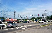
town line, where NY 300 expands to two lanes in both directions as it crosses into Newburgh. The next three miles (5 km) of NY 300 serves as the town's main commercial strip, featuring several national chain store
s and smaller, more local businesses. A middle turn lane exists from the NY 17K
junction all the way up to NY 52
. North of NY 17K, the highway runs by a few hotels and offices on its way to a junction with Interstate 84
and the Thruway (Interstate 87). Past this junction, NY 300 passes the modest Newburgh Mall
and an assortment of other retail establishments until the commercial zoning
finally ends at the NY 52 intersection, which marks the center of an area of the town of Newburgh known as Gardnertown
. The hamlet is named for Silas Gardner, an early settler whose stone house
is still in use just north of the intersection, past the Orange Lake
outlet brook.
made left turns onto Union Avenue illegal. The number of accidents did not decrease at first due to widespread ignoring of the no left turn signs; however, increased vigilance by the Newburgh police has cut down significantly on accidents at this "Y" intersection. Now named Union Avenue Extension, NY 300 heads northeast, crossing Gardnertown Road at an intersection with a full four-way traffic light
. At this point, it passes the town of Newburgh's Town Hall, Code Compliance Building, and Police Headquarters. Just beyond this triumvirate of municipal buildings is the current Gardnertown Magnet School of the Newburgh Enlarged City School District
, where NY 300 becomes Plattekill Turnpike.
 After 1.5 miles (2.4 km) of both commercial and residential properties, including the Gardnertown Riding Stables, the highway reaches the Town Court at the junction with NY 32
, which marks the center of an area of town named Cronomer Valley. While the junction is a standard four-way intersection, the highways do not intersect as such. Instead, NY 32 enters from the southeast and leaves to the north while NY 300 turns left and heads to the northwest past the south end of Chadwick Lake
, the town's reservoir. This section of NY 300 is largely a rural two-lane road that serves as a connector between Newburgh and Wallkill
, a hamlet in the adjacent Ulster County
. As it heads to Wallkill, NY 300 crosses the Thruway on a bridge rebuilt in 2005 that featuring the only integrated pier cap type bridge to be found in the area.
The route continues northwest across a rural section of the town to the Ulster County line near the top of Kings Hill, one of the highest elevations in the town. NY 300 briefly turns to the north and parallels the county line before veering to the west and passing into Ulster County and the town of Shawangunk
. Within the town, the last on NY 300, the route trends in a more westerly direction toward Wallkill. The route ends just shy of the hamlet at a junction with NY 208
northeast of the community.
to Cronomer Valley was taken over by the state of New York
by 1926 and designated as NY 300 as part of the 1930 renumbering of state highways in New York. At some point between 1942 and 1954, NY 300 was extended southeastward to U.S. Route 9W at the Newburgh
city limits, creating a 3 miles (5 km) overlap with NY 32
from Cronomer Valley to US 9W. NY 300 terminated at this point while NY 32 continued south along US 9W as it does to this day. Motorists proceeding straight at this intersection had a direct route to the Newburgh waterfront and the Newburgh–Beacon Ferry across the Hudson River
.
 The intersection of Plank Road (NY 32) and Albany Post Road (US 9W) was reconfigured slightly as part of the construction of Interstate 84 and the Newburgh-Beacon Bridge
. In order to avoid crossing under the freeway at exit 10, the section of Plank Road carrying NY 32 and NY 300 was relocated to the north of I-84. As a result, it now intersects with US 9W about 0.3 mile (0.482802 km) north of the old intersection. When the bridge and I-84 were completed through Newburgh in 1963, the concurrency between NY 32 and NY 300 was abolished and NY 300 was truncated back to its original terminus at Cronomer Valley.
as parts of several county routes. Plattekill Turnpike and Union Avenue were designated as County Route 28 (CR 28) from Cronomer Valley to NY 52
, CR 10 from there to I-84, and CR 38 from NY 17K
to NY 207
east of Stewart International Airport
. Temple Hill Road, meanwhile, was designated as CR 59. The section of Union Avenue between I-84 and NY 17K was state-maintained as an unsigned reference route.
On April 1, 1980, the state of New York
assumed ownership and maintenance of CR 10, CR 28, CR 38, and CR 59 as part of a highway maintenance swap between the state and Orange County. The new north–south state highway became part of an extended NY 300, which made a 90-degree turn at Cronomer Valley and proceeded south to Vails Gate
, briefly overlapping NY 207 in the vicinity of Lake Washington. This change roughly doubled the length of NY 300 (from 7 miles or 11 km to 15 miles or 24 km) and also resulted in the re-signing of NY 300 from an east–west route to a north–south route.
The original east–west orientation of NY 300 is reflected in the mileage given on the route's reference marker
s. Mileposts on the highway begin at the route's original western terminus at NY 208
in Wallkill and increase as the route heads east and south toward Vail Mills. As such, the markers on the route run contrary to the New York State Department of Transportation
's standard practice of inventorying a north–south route from south to north.
The section concurrent with NY 207 was relocated slightly when it was widened just east of the Thruway. The former right-of-way is still visible in the woods just north of the roadway.
and the local governments no longer recognize them as valid road names. Since the adoption of the 911 emergency system in 1997, the entire length of the road is now referred to officially as "Route 300", with the old names of Plattekill Turnpike, Union Avenue Extension, Union Avenue and Temple Hill Road being suppressed by the local governments and by the U.S. Postal Service. The name Route 300 has even replaced the old name North Plank Road west of Cronomer Valley, even though the name is retained by the Postal Service east of that intersection. Interestingly, the large signs on Interstate 84 still refer to NY 300 as Union Avenue, however, even though local and official use of this name has been suppressed for the past decade.
opened near Newburgh in 1955, exit 17 was a standard trumpet interchange that connected to Union Avenue and NY 17K
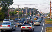
. Interstate 84 was opened north and east of the junction in 1963 and west of the junction in 1969. No direct connection was built between I-84 and the Thruway, forcing traffic to utilize a short stretch of Union Avenue. At the time the Thruway was built there was little traffic on what later became NY 300 (at that time, a county road); the completion of I-84 and the subsequent development of the NY 300 corridor has increased traffic volumes in the area significantly.
In this setup, traffic left the freeway and encountered stop signs and traffic signals while traveling from one road to the other. The inadequate cloverleaf
design of the junction between I-84 and Union Avenue led to problems, especially with articulateds
, which must slow significantly to negotiate the sharp loop slips, and weave with traffic attempting to leave the freeway westbound. The I-84 off-slips had stop signs at the NY 300 termini; and there was no cloverleaf weaving area northbound through the junction. Southbound, traffic had to weave to join NY 300, or bear right to join the Thruway.
For many years state and local officials had wanted to build a direct connection between I-84 and the Thruway; however, federal funding did not become available until the very end of the 20th century. The New York State Thruway Authority had a project in the works to link exit 17 directly with I-84, bypassing NY 300; and reconstruct the interchange between NY 300 and I-84 (exit 7). Plans online showed this as a diamond junction for the Interstate 84/NY 300 link; but there are signals in place for a left turn not shown in the Thruway Authority plans.
The junction between the Thruway and Interstate 84 works were begun in 2001 but the project was delayed when the original contractor for the job was found to have ties to organized crime. As of May 2006, total work on the project consisted of a rebuilding of the eastbound exit 7 off-slip, removal of the southbound NY 300 to eastbound I-84 loop slip, installation of a traffic light, and the rerouting of the southbound NY 300 to eastbound I-84 movement via the same slip ramp that services the northbound NY 300 to eastbound I-84 movement.
The ramp for northbound exit 17 on the Thruway has been widened to two lanes and new signage has gone up on the northbound Thruway and westbound I-84.
The direct connection between I-84 and the Thruway was finally completed in December 2009, after being under construction for five years.
State highway
State highway, state road or state route can refer to one of three related concepts, two of them related to a state or provincial government in a country that is divided into states or provinces :#A...
located west of the city of Newburgh
Newburgh (city), New York
Newburgh is a city located in Orange County, New York, United States, north of New York City, and south of Albany, on the Hudson River. Newburgh is a principal city of the Poughkeepsie-Newburgh-Middletown metropolitan area, which includes all of Dutchess and Orange counties. The Newburgh area was...
in the Hudson Valley
Hudson Valley
The Hudson Valley comprises the valley of the Hudson River and its adjacent communities in New York State, United States, from northern Westchester County northward to the cities of Albany and Troy.-History:...
of New York
New York
New York is a state in the Northeastern region of the United States. It is the nation's third most populous state. New York is bordered by New Jersey and Pennsylvania to the south, and by Connecticut, Massachusetts and Vermont to the east...
in the United States
United States
The United States of America is a federal constitutional republic comprising fifty states and a federal district...
. The southern terminus of the route is at a five-way intersection with NY 32
New York State Route 32
New York State Route 32 is a north–south state highway that extends for through the Hudson Valley and Capital District regions of the U.S. state of New York. It is a two-lane surface road for nearly its entire length, with few divided and no limited-access sections. From Harriman to Albany,...
and NY 94
New York State Route 94
New York State Route 94 is a state highway entirely within Orange County in southern New York. The western terminus is at the New York-New Jersey state line, where it continues as NJ 94 for another to Columbia, New Jersey. Its eastern terminus is located at U.S. Route 9W in New Windsor....
in the hamlet of Vails Gate
Vails Gate, New York
Vails Gate is a hamlet in Orange County, New York, United States. The population was 3,319 at the 2000 census. It is part of the Poughkeepsie–Newburgh–Middletown, NY Metropolitan Statistical Area as well as the larger New York–Newark–Bridgeport, NY-NJ-CT-PA Combined...
. From there, it runs generally northwesterly through the towns of New Windsor
New Windsor, New York
New Windsor is a town in Orange County, New York, United States. The population was estimated at 25,244 in 2010 by the US Census.The Town of New Windsor is in the eastern part of the county, bordering the Town of Newburgh and the City of Newburgh....
, Newburgh
Newburgh (town), New York
Newburgh is a town in Orange County, New York, United States. The 2010 census determined the population is 29,801. This is the first time ever that the population of the Town of Newburgh officially exceeded that of the adjacent but totally separate municipality known as the city of Newburgh...
, and Shawangunk
Shawangunk, New York
Shawangunk is a town in southwestern Ulster County, New York, United States. The population was 12,022 at the 2000 census. Like the neighboring mountain range, for which it is named, it is pronounced either as the Munsee Lenape, Shawangunk , or as the colonial Shongum by local residents...
, to a junction with NY 208
New York State Route 208
New York State Route 208 is a state highway located in southern New York in the United States. The southern terminus is at an intersection with NY 17M in the Orange County village of Monroe...
near the hamlet of Wallkill
Wallkill, Ulster County, New York
Wallkill is a hamlet , generally identified as coterminous with ZIP code 12589, telephone exchange 895 in the 845 area code and most of the Wallkill Central School District located mostly in the eastern half of the Town of Shawangunk, Ulster County, New York but partly spilling over into adjacent...
. NY 300's two major changes of direction are marked by slightly unorthodox intersections with other state highways.
Vails Gate to Interstate 84
NY 300 begins at a five-pronged junction with NY 32New York State Route 32
New York State Route 32 is a north–south state highway that extends for through the Hudson Valley and Capital District regions of the U.S. state of New York. It is a two-lane surface road for nearly its entire length, with few divided and no limited-access sections. From Harriman to Albany,...
and NY 94
New York State Route 94
New York State Route 94 is a state highway entirely within Orange County in southern New York. The western terminus is at the New York-New Jersey state line, where it continues as NJ 94 for another to Columbia, New Jersey. Its eastern terminus is located at U.S. Route 9W in New Windsor....
in the hamlet of Vails Gate
Vails Gate, New York
Vails Gate is a hamlet in Orange County, New York, United States. The population was 3,319 at the 2000 census. It is part of the Poughkeepsie–Newburgh–Middletown, NY Metropolitan Statistical Area as well as the larger New York–Newark–Bridgeport, NY-NJ-CT-PA Combined...
, also known as the Five Corners. The route heads north as Temple Hill Road, paralleling the New York State Thruway
New York State Thruway
The New York State Thruway is a system of limited-access highways located within the state of New York in the United States. The system, known officially as the Governor Thomas E. Dewey Thruway for former New York Governor Thomas E. Dewey, is operated by the New York State Thruway Authority and...
as it passes the New Windsor Cantonment State Historic Site
New Windsor Cantonment State Historic Site
The New Windsor Cantonment State Historic Site, also known as New Windsor Cantonment, is located along NY 300 a mile north of Vails Gate in Orange County's Town of New Windsor. The site features reconstruction buildings of the final encampment of the Continental Army.Between June 1782 and October...
, where George Washington
George Washington
George Washington was the dominant military and political leader of the new United States of America from 1775 to 1799. He led the American victory over Great Britain in the American Revolutionary War as commander-in-chief of the Continental Army from 1775 to 1783, and presided over the writing of...
dismissed the Continental Army
Continental Army
The Continental Army was formed after the outbreak of the American Revolutionary War by the colonies that became the United States of America. Established by a resolution of the Continental Congress on June 14, 1775, it was created to coordinate the military efforts of the Thirteen Colonies in...
in 1783. Following that, the highway begins to curve to the west ahead of an intersection with County Route 69, named Union Avenue. Here, NY 300 takes on the Union Avenue name just before intersecting and converging with NY 207
New York State Route 207
New York State Route 207 is a state highway located entirely within Orange County, New York, in the United States. It serves as a connector between the village of Goshen and the city of Newburgh. It has for a long time provided the main access to Stewart International Airport...
(Little Britain Road) adjacent to the James "Squire" Patton House
James "Squire" Patton House
The James "Squire" Patton House is located along the brief overlap of NY 207 and 300 in New Windsor, New York, United States. It is on a five-acre parcel owned by the nearby city of Newburgh, used for police K-9 training....
—now the city of Newburgh's police K-9
Police dog
A police dog, often referred to as a "K-9 dog" in some areas , is a dog that is trained specifically to assist police and other law-enforcement personnel in their work...
unit training facility—at the southern tip of Lake Washington. At the next junction 0.4 mile (0.643736 km) later, a signalized intersection just east of a Thruway overpass, NY 207 continues straight ahead to the west toward Goshen
Goshen (village), New York
Goshen is a village in and the county seat of Orange County, New York, United States. The population was 5,676 at the 2000 census. It is part of the Poughkeepsie–Newburgh–Middletown, NY Metropolitan Statistical Area as well as the larger New York–Newark–Bridgeport,...
while NY 300 turns right and heads north.
New Windsor, New York
New Windsor is a town in Orange County, New York, United States. The population was estimated at 25,244 in 2010 by the US Census.The Town of New Windsor is in the eastern part of the county, bordering the Town of Newburgh and the City of Newburgh....
–Newburgh
Newburgh (town), New York
Newburgh is a town in Orange County, New York, United States. The 2010 census determined the population is 29,801. This is the first time ever that the population of the Town of Newburgh officially exceeded that of the adjacent but totally separate municipality known as the city of Newburgh...
town line, where NY 300 expands to two lanes in both directions as it crosses into Newburgh. The next three miles (5 km) of NY 300 serves as the town's main commercial strip, featuring several national chain store
Chain store
Chain stores are retail outlets that share a brand and central management, and usually have standardized business methods and practices. These characteristics also apply to chain restaurants and some service-oriented chain businesses. In retail, dining and many service categories, chain businesses...
s and smaller, more local businesses. A middle turn lane exists from the NY 17K
New York State Route 17K
New York State Route 17K is an east–west state highway located within Orange County, New York, in the United States. It extends for from an intersection with County Route 76 east of Bloomingburg to a junction with U.S. Route 9W midway across the city of Newburgh...
junction all the way up to NY 52
New York State Route 52
New York State Route 52 is a long state highway in the southeastern part of New York in the United States. It generally runs from west to east, beginning at the Pennsylvania state line in the Delaware River near Narrowsburg, crossing the Hudson River on the Newburgh-Beacon Bridge, and ending...
. North of NY 17K, the highway runs by a few hotels and offices on its way to a junction with Interstate 84
Interstate 84 in New York
Interstate 84 is a part of the Interstate Highway System that runs from Dunmore, Pennsylvania, to Sturbridge, Massachusetts, in the Eastern United States. In New York, I-84 extends from the Pennsylvania state line at Port Jervis to the Connecticut state line east of Brewster...
and the Thruway (Interstate 87). Past this junction, NY 300 passes the modest Newburgh Mall
Newburgh Mall
The Newburgh Mall is a regional shopping center located on NY 300 in the Town of Newburgh, New York, near where Interstate 87 intersects with Interstate 84. It was opened in 1980 by Kravco property management , which owns the King of Prussia Mall outside of Philadelphia...
and an assortment of other retail establishments until the commercial zoning
Zoning
Zoning is a device of land use planning used by local governments in most developed countries. The word is derived from the practice of designating permitted uses of land based on mapped zones which separate one set of land uses from another...
finally ends at the NY 52 intersection, which marks the center of an area of the town of Newburgh known as Gardnertown
Gardnertown, New York
Gardnertown is a hamlet in Orange County, New York, United States. The population was 4,533 at the 2000 census. It is part of the Poughkeepsie–Newburgh–Middletown, NY Metropolitan Statistical Area as well as the larger New York–Newark–Bridgeport, NY-NJ-CT-PA Combined...
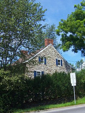
. The hamlet is named for Silas Gardner, an early settler whose stone house
Silas Gardner House
The Silas Gardner House is a colonial stone house at the junction of routes 52 and 300 in the Gardnertown section of the Town of Newburgh in Orange County, New York. It has been listed on the National Register of Historic Places since 1980....
is still in use just north of the intersection, past the Orange Lake
Orange Lake, New York
Orange Lake is a hamlet in Orange County, New York, United States. The population was 6,085 at the 2000 census. Newburgh–Middletown, NY Metropolitan Statistical Area as well as the larger New York–Newark–Bridgeport, NY-NJ-CT-PA Combined Statistical Area.The community of Orange...
outlet brook.
North of Interstate 84
Immediately north of the NY 52 junction, NY 300 reverts to two lanes as Union Avenue leaves the route to the northwest as a town road. Increased traffic and poor visibility made the junction with Union Avenue a dangerous intersection; accordingly, in 2005 the New York State Department of TransportationNew York State Department of Transportation
The New York State Department of Transportation is responsible for the development and operation of highways, railroads, mass transit systems, ports, waterways and aviation facilities in the U.S...
made left turns onto Union Avenue illegal. The number of accidents did not decrease at first due to widespread ignoring of the no left turn signs; however, increased vigilance by the Newburgh police has cut down significantly on accidents at this "Y" intersection. Now named Union Avenue Extension, NY 300 heads northeast, crossing Gardnertown Road at an intersection with a full four-way traffic light
Traffic light
Traffic lights, which may also be known as stoplights, traffic lamps, traffic signals, signal lights, robots or semaphore, are signalling devices positioned at road intersections, pedestrian crossings and other locations to control competing flows of traffic...
. At this point, it passes the town of Newburgh's Town Hall, Code Compliance Building, and Police Headquarters. Just beyond this triumvirate of municipal buildings is the current Gardnertown Magnet School of the Newburgh Enlarged City School District
Newburgh Enlarged City School District
The Newburgh Enlarged City School District is a public school district located in Newburgh, New York. It encompassed all of the city of Newburgh, and most of the Towns of Newburgh, and New Windsor. The enrollment is 12,791 students in 13 schools in grades K-12. The district superintendent is Ralph...
, where NY 300 becomes Plattekill Turnpike.
New York State Route 32
New York State Route 32 is a north–south state highway that extends for through the Hudson Valley and Capital District regions of the U.S. state of New York. It is a two-lane surface road for nearly its entire length, with few divided and no limited-access sections. From Harriman to Albany,...
, which marks the center of an area of town named Cronomer Valley. While the junction is a standard four-way intersection, the highways do not intersect as such. Instead, NY 32 enters from the southeast and leaves to the north while NY 300 turns left and heads to the northwest past the south end of Chadwick Lake
Chadwick Lake
Chadwick Lake is a reservoir supplying water to the Town of Newburgh, in Orange County, New York, United States. It was created by damming Quassaick Creek in 1926. It is located immediately to the northwest of the junction of NY 32 and 300 in the Cronomer Valley section of the town...
, the town's reservoir. This section of NY 300 is largely a rural two-lane road that serves as a connector between Newburgh and Wallkill
Wallkill, Ulster County, New York
Wallkill is a hamlet , generally identified as coterminous with ZIP code 12589, telephone exchange 895 in the 845 area code and most of the Wallkill Central School District located mostly in the eastern half of the Town of Shawangunk, Ulster County, New York but partly spilling over into adjacent...
, a hamlet in the adjacent Ulster County
Ulster County, New York
Ulster County is a county located in the state of New York, USA. It sits in the state's Mid-Hudson Region of the Hudson Valley. As of the 2010 census, the population was 182,493. Recent population estimates completed by the United States Census Bureau for the 12-month period ending July 1 are at...
. As it heads to Wallkill, NY 300 crosses the Thruway on a bridge rebuilt in 2005 that featuring the only integrated pier cap type bridge to be found in the area.
The route continues northwest across a rural section of the town to the Ulster County line near the top of Kings Hill, one of the highest elevations in the town. NY 300 briefly turns to the north and parallels the county line before veering to the west and passing into Ulster County and the town of Shawangunk
Shawangunk, New York
Shawangunk is a town in southwestern Ulster County, New York, United States. The population was 12,022 at the 2000 census. Like the neighboring mountain range, for which it is named, it is pronounced either as the Munsee Lenape, Shawangunk , or as the colonial Shongum by local residents...
. Within the town, the last on NY 300, the route trends in a more westerly direction toward Wallkill. The route ends just shy of the hamlet at a junction with NY 208
New York State Route 208
New York State Route 208 is a state highway located in southern New York in the United States. The southern terminus is at an intersection with NY 17M in the Orange County village of Monroe...
northeast of the community.
Designation
The east–west portion of modern NY 300 from WallkillWallkill, Orange County, New York
Wallkill is a town in Orange County, New York, United States. The population was 24,659 at the 2000 census.The Town of Wallkill is centrally located in the county. Interstate 84 crosses New York State Route 17 in the southern part of the town. U.S...
to Cronomer Valley was taken over by the state of New York
New York
New York is a state in the Northeastern region of the United States. It is the nation's third most populous state. New York is bordered by New Jersey and Pennsylvania to the south, and by Connecticut, Massachusetts and Vermont to the east...
by 1926 and designated as NY 300 as part of the 1930 renumbering of state highways in New York. At some point between 1942 and 1954, NY 300 was extended southeastward to U.S. Route 9W at the Newburgh
Newburgh (city), New York
Newburgh is a city located in Orange County, New York, United States, north of New York City, and south of Albany, on the Hudson River. Newburgh is a principal city of the Poughkeepsie-Newburgh-Middletown metropolitan area, which includes all of Dutchess and Orange counties. The Newburgh area was...
city limits, creating a 3 miles (5 km) overlap with NY 32
New York State Route 32
New York State Route 32 is a north–south state highway that extends for through the Hudson Valley and Capital District regions of the U.S. state of New York. It is a two-lane surface road for nearly its entire length, with few divided and no limited-access sections. From Harriman to Albany,...
from Cronomer Valley to US 9W. NY 300 terminated at this point while NY 32 continued south along US 9W as it does to this day. Motorists proceeding straight at this intersection had a direct route to the Newburgh waterfront and the Newburgh–Beacon Ferry across the Hudson River
Hudson River
The Hudson is a river that flows from north to south through eastern New York. The highest official source is at Lake Tear of the Clouds, on the slopes of Mount Marcy in the Adirondack Mountains. The river itself officially begins in Henderson Lake in Newcomb, New York...
.
Newburgh-Beacon Bridge
The Newburgh–Beacon Bridge, is a cantilever toll bridge that spans the Hudson River in New York State carrying NY 52 and Interstate 84 between Newburgh and Beacon...
. In order to avoid crossing under the freeway at exit 10, the section of Plank Road carrying NY 32 and NY 300 was relocated to the north of I-84. As a result, it now intersects with US 9W about 0.3 mile (0.482802 km) north of the old intersection. When the bridge and I-84 were completed through Newburgh in 1963, the concurrency between NY 32 and NY 300 was abolished and NY 300 was truncated back to its original terminus at Cronomer Valley.
Southward extension
Prior to 1980, most of what is now NY 300 south of Cronomer Valley—namely Plattekill Turnpike, Union Avenue and Temple Hill Road—was maintained by Orange CountyOrange County, New York
Orange County is a county located in the U.S. state of New York. It is part of the Poughkeepsie–Newburgh–Middletown, NY Metropolitan Statistical Area and is located at the northern reaches of the New York metropolitan area. The county sits in the state's scenic Mid-Hudson Region of the Hudson Valley...
as parts of several county routes. Plattekill Turnpike and Union Avenue were designated as County Route 28 (CR 28) from Cronomer Valley to NY 52
New York State Route 52
New York State Route 52 is a long state highway in the southeastern part of New York in the United States. It generally runs from west to east, beginning at the Pennsylvania state line in the Delaware River near Narrowsburg, crossing the Hudson River on the Newburgh-Beacon Bridge, and ending...
, CR 10 from there to I-84, and CR 38 from NY 17K
New York State Route 17K
New York State Route 17K is an east–west state highway located within Orange County, New York, in the United States. It extends for from an intersection with County Route 76 east of Bloomingburg to a junction with U.S. Route 9W midway across the city of Newburgh...
to NY 207
New York State Route 207
New York State Route 207 is a state highway located entirely within Orange County, New York, in the United States. It serves as a connector between the village of Goshen and the city of Newburgh. It has for a long time provided the main access to Stewart International Airport...
east of Stewart International Airport
Stewart International Airport
Stewart International Airport is located in the southern Hudson Valley, west of Newburgh, New York and over north of Midtown Manhattan, New York City. The airport is located in the Town of Newburgh and the Town of New Windsor."." U.S. Census Bureau...
. Temple Hill Road, meanwhile, was designated as CR 59. The section of Union Avenue between I-84 and NY 17K was state-maintained as an unsigned reference route.
On April 1, 1980, the state of New York
New York
New York is a state in the Northeastern region of the United States. It is the nation's third most populous state. New York is bordered by New Jersey and Pennsylvania to the south, and by Connecticut, Massachusetts and Vermont to the east...
assumed ownership and maintenance of CR 10, CR 28, CR 38, and CR 59 as part of a highway maintenance swap between the state and Orange County. The new north–south state highway became part of an extended NY 300, which made a 90-degree turn at Cronomer Valley and proceeded south to Vails Gate
Vails Gate, New York
Vails Gate is a hamlet in Orange County, New York, United States. The population was 3,319 at the 2000 census. It is part of the Poughkeepsie–Newburgh–Middletown, NY Metropolitan Statistical Area as well as the larger New York–Newark–Bridgeport, NY-NJ-CT-PA Combined...
, briefly overlapping NY 207 in the vicinity of Lake Washington. This change roughly doubled the length of NY 300 (from 7 miles or 11 km to 15 miles or 24 km) and also resulted in the re-signing of NY 300 from an east–west route to a north–south route.
The original east–west orientation of NY 300 is reflected in the mileage given on the route's reference marker
Reference marker (New York)
In New York, a reference marker is a small green sign mounted approximately every one-tenth mile on highways maintained by the New York State Department of Transportation. This was initiated in response to the Highway Safety Act of 1966 enacted by Congress, in an effort to monitor traffic and...
s. Mileposts on the highway begin at the route's original western terminus at NY 208
New York State Route 208
New York State Route 208 is a state highway located in southern New York in the United States. The southern terminus is at an intersection with NY 17M in the Orange County village of Monroe...
in Wallkill and increase as the route heads east and south toward Vail Mills. As such, the markers on the route run contrary to the New York State Department of Transportation
New York State Department of Transportation
The New York State Department of Transportation is responsible for the development and operation of highways, railroads, mass transit systems, ports, waterways and aviation facilities in the U.S...
's standard practice of inventorying a north–south route from south to north.
The section concurrent with NY 207 was relocated slightly when it was widened just east of the Thruway. The former right-of-way is still visible in the woods just north of the roadway.
Road names
The original street names for the north–south section of NY 300 still enjoy wide local usage even though both the United States Postal ServiceUnited States Postal Service
The United States Postal Service is an independent agency of the United States government responsible for providing postal service in the United States...
and the local governments no longer recognize them as valid road names. Since the adoption of the 911 emergency system in 1997, the entire length of the road is now referred to officially as "Route 300", with the old names of Plattekill Turnpike, Union Avenue Extension, Union Avenue and Temple Hill Road being suppressed by the local governments and by the U.S. Postal Service. The name Route 300 has even replaced the old name North Plank Road west of Cronomer Valley, even though the name is retained by the Postal Service east of that intersection. Interestingly, the large signs on Interstate 84 still refer to NY 300 as Union Avenue, however, even though local and official use of this name has been suppressed for the past decade.
I-84/Thruway junction
When the New York State ThruwayNew York State Thruway
The New York State Thruway is a system of limited-access highways located within the state of New York in the United States. The system, known officially as the Governor Thomas E. Dewey Thruway for former New York Governor Thomas E. Dewey, is operated by the New York State Thruway Authority and...
opened near Newburgh in 1955, exit 17 was a standard trumpet interchange that connected to Union Avenue and NY 17K
New York State Route 17K
New York State Route 17K is an east–west state highway located within Orange County, New York, in the United States. It extends for from an intersection with County Route 76 east of Bloomingburg to a junction with U.S. Route 9W midway across the city of Newburgh...
. Interstate 84 was opened north and east of the junction in 1963 and west of the junction in 1969. No direct connection was built between I-84 and the Thruway, forcing traffic to utilize a short stretch of Union Avenue. At the time the Thruway was built there was little traffic on what later became NY 300 (at that time, a county road); the completion of I-84 and the subsequent development of the NY 300 corridor has increased traffic volumes in the area significantly.
In this setup, traffic left the freeway and encountered stop signs and traffic signals while traveling from one road to the other. The inadequate cloverleaf
Cloverleaf interchange
A cloverleaf interchange is a two-level interchange in which left turns, reverse direction in left-driving regions, are handled by ramp roads...
design of the junction between I-84 and Union Avenue led to problems, especially with articulateds
Articulated vehicle
An articulated vehicle is a vehicle which has a permanent or semi-permanent pivoting joint in its construction, allowing the vehicle to turn more sharply. There are many kinds of articulated vehicles, from heavy equipment to buses, trams and trains...
, which must slow significantly to negotiate the sharp loop slips, and weave with traffic attempting to leave the freeway westbound. The I-84 off-slips had stop signs at the NY 300 termini; and there was no cloverleaf weaving area northbound through the junction. Southbound, traffic had to weave to join NY 300, or bear right to join the Thruway.
For many years state and local officials had wanted to build a direct connection between I-84 and the Thruway; however, federal funding did not become available until the very end of the 20th century. The New York State Thruway Authority had a project in the works to link exit 17 directly with I-84, bypassing NY 300; and reconstruct the interchange between NY 300 and I-84 (exit 7). Plans online showed this as a diamond junction for the Interstate 84/NY 300 link; but there are signals in place for a left turn not shown in the Thruway Authority plans.
The junction between the Thruway and Interstate 84 works were begun in 2001 but the project was delayed when the original contractor for the job was found to have ties to organized crime. As of May 2006, total work on the project consisted of a rebuilding of the eastbound exit 7 off-slip, removal of the southbound NY 300 to eastbound I-84 loop slip, installation of a traffic light, and the rerouting of the southbound NY 300 to eastbound I-84 movement via the same slip ramp that services the northbound NY 300 to eastbound I-84 movement.
The ramp for northbound exit 17 on the Thruway has been widened to two lanes and new signage has gone up on the northbound Thruway and westbound I-84.
The direct connection between I-84 and the Thruway was finally completed in December 2009, after being under construction for five years.