
New Durham, New Hampshire
Encyclopedia
New Durham is a town
in Strafford County
, New Hampshire
, United States
. The population was 2,638 at the 2010 census. It is drained by the Merrymeeting
and Ela
rivers, and is known for Merrymeeting Lake
. New Durham is home to the Powder Mill Fish Hatchery. Also located here is the Lions Club's
Camp Pride, a camp for children and adults with special needs.
. It would be incorporated as New Durham on December 7, 1762. With a somewhat uneven and rocky surface, the town was better suited to grazing
than cultivation
. Lumber
became the chief article of trade, and by 1859 New Durham had five sawmill
s and four shingle
mills. It also had two gristmill
s, and a gunpowder
factory called the Eureka Powder Works. On September 19, 1849, the Cocheco Railroad opened through the town, connecting Dover
with Alton Bay
.
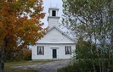
An early town minister, Reverend Benjamin Randall
, founded a new religious denomination in 1780 called the Free Will Baptists
, later known as Free Baptists. The church has two buildings in the community, the older built in 1819 on New Durham Ridge.
, the town has a total area of 44.1 square miles (114.2 km²), of which 41.5 sq mi (107.5 km²) is land and 2.6 sq mi (6.7 km²) is water, comprising 5.98% of the town. It is drained by the Ela River
, Merrymeeting River
and the Cocheco River. New Durham's highest point is 1700 feet (518.2 m) above sea level
, on the western slope of Copple Crown Mountain, along the town's eastern border. The mountain's 1868 feet (569.4 m) summit is in the neighboring town of Brookfield
.
New Durham is served by New Hampshire Route 11
.
of 2000, there were 2,220 people, 819 households, and 630 families residing in the town. The population density
was 53.2 people per square mile (20.6/km²). There were 1,309 housing units at an average density of 31.4 per square mile (12.1/km²). The racial makeup of the town was 98.15% White, 0.23% African American, 0.18% Native American, 0.54% Asian, 0.27% from other races
, and 0.63% from two or more races. Hispanic or Latino of any race were 0.41% of the population.
There were 819 households out of which 36.1% had children under the age of 18 living with them, 67.2% were married couples
living together, 4.9% had a female householder with no husband present, and 23.0% were non-families. 17.0% of all households were made up of individuals and 5.6% had someone living alone who was 65 years of age or older. The average household size was 2.71 and the average family size was 3.05.
In the town the population was spread out with 27.3% under the age of 18, 4.3% from 18 to 24, 32.8% from 25 to 44, 24.9% from 45 to 64, and 10.7% who were 65 years of age or older. The median age was 38 years. For every 100 females there were 107.7 males. For every 100 females age 18 and over, there were 106.5 males.
The median income for a household in the town was $52,270, and the median income for a family was $52,941. Males had a median income of $35,574 versus $28,092 for females. The per capita income
for the town was $22,139. About 3.7% of families and 5.1% of the population were below the poverty line, including 5.9% of those under age 18 and 6.6% of those age 65 or over.
New England town
The New England town is the basic unit of local government in each of the six New England states. Without a direct counterpart in most other U.S. states, New England towns are conceptually similar to civil townships in other states, but are incorporated, possessing powers like cities in other...
in Strafford County
Strafford County, New Hampshire
-Demographics:As of the census of 2000, there were 112,233 people, 42,581 households, and 27,762 families residing in the county. The population density was 304 people per square mile . There were 45,539 housing units at an average density of 124 per square mile...
, New Hampshire
New Hampshire
New Hampshire is a state in the New England region of the northeastern United States of America. The state was named after the southern English county of Hampshire. It is bordered by Massachusetts to the south, Vermont to the west, Maine and the Atlantic Ocean to the east, and the Canadian...
, United States
United States
The United States of America is a federal constitutional republic comprising fifty states and a federal district...
. The population was 2,638 at the 2010 census. It is drained by the Merrymeeting
Merrymeeting River
The Merrymeeting River is a river located in the Lakes Region of central New Hampshire in the United States. It is a tributary of Lake Winnipesaukee, part of the Merrimack River watershed....
and Ela
Ela River
The Ela River is a 10.6 mile long river located in eastern New Hampshire in the United States. It is a tributary of the Cocheco River, part of the Piscataqua River watershed leading to the Atlantic Ocean....
rivers, and is known for Merrymeeting Lake
Merrymeeting Lake
Merrymeeting Lake is a water body located in Strafford County in eastern New Hampshire, United States, in the town of New Durham. Its outlet is the Merrymeeting River, flowing south and then northwest to Lake Winnipesaukee....
. New Durham is home to the Powder Mill Fish Hatchery. Also located here is the Lions Club's
Lions Clubs International
Lions Clubs International is a secular service organization with over 44,500 clubs and more than 1,368,683 members in 191 countries around the world founded by Melvin Jones Headquartered in Oak Brook, Illinois, United States, the organization aims to meet the needs of communities on a local and...
Camp Pride, a camp for children and adults with special needs.
History
Granted by the Masonian Proprietors in 1749 as Cochecho Township, New Durham was settled in 1750 almost entirely by colonists from DurhamDurham, New Hampshire
As of the census of 2000, there were 12,664 people, 2,882 households, and 1,582 families residing in the town. The population density was 565.5 people per square mile . There were 2,923 housing units at an average density of 130.5 per square mile...
. It would be incorporated as New Durham on December 7, 1762. With a somewhat uneven and rocky surface, the town was better suited to grazing
Grazing
Grazing generally describes a type of feeding, in which a herbivore feeds on plants , and also on other multicellular autotrophs...
than cultivation
Tillage
Tillage is the agricultural preparation of the soil by mechanical agitation of various types, such as digging, stirring, and overturning. Examples of human-powered tilling methods using hand tools include shovelling, picking, mattock work, hoeing, and raking...
. Lumber
Lumber
Lumber or timber is wood in any of its stages from felling through readiness for use as structural material for construction, or wood pulp for paper production....
became the chief article of trade, and by 1859 New Durham had five sawmill
Sawmill
A sawmill is a facility where logs are cut into boards.-Sawmill process:A sawmill's basic operation is much like those of hundreds of years ago; a log enters on one end and dimensional lumber exits on the other end....
s and four shingle
Roof shingle
Roof shingles are a roof covering consisting of individual overlapping elements. These elements are typically flat rectangular shapes laid in rows from the bottom edge of the roof up, with each successive higher row overlapping the joints in the row below...
mills. It also had two gristmill
Gristmill
The terms gristmill or grist mill can refer either to a building in which grain is ground into flour, or to the grinding mechanism itself.- Early history :...
s, and a gunpowder
Gunpowder
Gunpowder, also known since in the late 19th century as black powder, was the first chemical explosive and the only one known until the mid 1800s. It is a mixture of sulfur, charcoal, and potassium nitrate - with the sulfur and charcoal acting as fuels, while the saltpeter works as an oxidizer...
factory called the Eureka Powder Works. On September 19, 1849, the Cocheco Railroad opened through the town, connecting Dover
Dover, New Hampshire
Dover is a city in Strafford County, New Hampshire, in the United States of America. The population was 29,987 at the 2010 census, the largest in the New Hampshire Seacoast region...
with Alton Bay
Alton Bay, New Hampshire
Alton Bay is an unincorporated village in the town of Alton, New Hampshire, located on Alton Bay, a cove of Lake Winnipesaukee which forms the southeasternmost point on the lake. The village is part of the Lakes Region, a popular resort area of New Hampshire....
.
An early town minister, Reverend Benjamin Randall
Benjamin Randall
Benjamin Randall was the main organizer of the Freewill Baptists in the northeastern United States.In 1749 Benjamin Randall was born into a New England sea captain's family. Randall experienced a conversion to Christianity in 1770 through the influence of George Whitefield. Randall served in the...
, founded a new religious denomination in 1780 called the Free Will Baptists
Free Will Baptist Church
Free Will Baptist is a denomination of churches that share a common history, name, and an acceptance of the Arminian theology of free grace, free salvation, and free will. Free Will Baptists share similar soteriological views with General Baptists, Separate Baptists and some United Baptists...
, later known as Free Baptists. The church has two buildings in the community, the older built in 1819 on New Durham Ridge.
Geography
According to the United States Census BureauUnited States Census Bureau
The United States Census Bureau is the government agency that is responsible for the United States Census. It also gathers other national demographic and economic data...
, the town has a total area of 44.1 square miles (114.2 km²), of which 41.5 sq mi (107.5 km²) is land and 2.6 sq mi (6.7 km²) is water, comprising 5.98% of the town. It is drained by the Ela River
Ela River
The Ela River is a 10.6 mile long river located in eastern New Hampshire in the United States. It is a tributary of the Cocheco River, part of the Piscataqua River watershed leading to the Atlantic Ocean....
, Merrymeeting River
Merrymeeting River
The Merrymeeting River is a river located in the Lakes Region of central New Hampshire in the United States. It is a tributary of Lake Winnipesaukee, part of the Merrimack River watershed....
and the Cocheco River. New Durham's highest point is 1700 feet (518.2 m) above sea level
Sea level
Mean sea level is a measure of the average height of the ocean's surface ; used as a standard in reckoning land elevation...
, on the western slope of Copple Crown Mountain, along the town's eastern border. The mountain's 1868 feet (569.4 m) summit is in the neighboring town of Brookfield
Brookfield, New Hampshire
Brookfield is a town in Carroll County, New Hampshire, United States. The population was 712 at the 2010 census.-History:Settled in 1726 by Scottish-Irish immigrants, the town was first named Coleraine. Fertile ground made it popular with farmers. It was later renamed Brookfield, after...
.
New Durham is served by New Hampshire Route 11
New Hampshire Route 11
New Hampshire Route 11 is a long east–west state highway in New Hampshire, running westward along the southern shore of Lake Winnipesaukee. Its eastern terminus is at the Maine state line in the city of Rochester, where it continues north as Maine State Route 11. U.S. Route 202, which runs...
.
Demographics
As of the censusCensus
A census is the procedure of systematically acquiring and recording information about the members of a given population. It is a regularly occurring and official count of a particular population. The term is used mostly in connection with national population and housing censuses; other common...
of 2000, there were 2,220 people, 819 households, and 630 families residing in the town. The population density
Population density
Population density is a measurement of population per unit area or unit volume. It is frequently applied to living organisms, and particularly to humans...
was 53.2 people per square mile (20.6/km²). There were 1,309 housing units at an average density of 31.4 per square mile (12.1/km²). The racial makeup of the town was 98.15% White, 0.23% African American, 0.18% Native American, 0.54% Asian, 0.27% from other races
Race (United States Census)
Race and ethnicity in the United States Census, as defined by the Federal Office of Management and Budget and the United States Census Bureau, are self-identification data items in which residents choose the race or races with which they most closely identify, and indicate whether or not they are...
, and 0.63% from two or more races. Hispanic or Latino of any race were 0.41% of the population.
There were 819 households out of which 36.1% had children under the age of 18 living with them, 67.2% were married couples
Marriage
Marriage is a social union or legal contract between people that creates kinship. It is an institution in which interpersonal relationships, usually intimate and sexual, are acknowledged in a variety of ways, depending on the culture or subculture in which it is found...
living together, 4.9% had a female householder with no husband present, and 23.0% were non-families. 17.0% of all households were made up of individuals and 5.6% had someone living alone who was 65 years of age or older. The average household size was 2.71 and the average family size was 3.05.
In the town the population was spread out with 27.3% under the age of 18, 4.3% from 18 to 24, 32.8% from 25 to 44, 24.9% from 45 to 64, and 10.7% who were 65 years of age or older. The median age was 38 years. For every 100 females there were 107.7 males. For every 100 females age 18 and over, there were 106.5 males.
The median income for a household in the town was $52,270, and the median income for a family was $52,941. Males had a median income of $35,574 versus $28,092 for females. The per capita income
Per capita income
Per capita income or income per person is a measure of mean income within an economic aggregate, such as a country or city. It is calculated by taking a measure of all sources of income in the aggregate and dividing it by the total population...
for the town was $22,139. About 3.7% of families and 5.1% of the population were below the poverty line, including 5.9% of those under age 18 and 6.6% of those age 65 or over.
Notable inhabitants
- Benjamin RandallBenjamin RandallBenjamin Randall was the main organizer of the Freewill Baptists in the northeastern United States.In 1749 Benjamin Randall was born into a New England sea captain's family. Randall experienced a conversion to Christianity in 1770 through the influence of George Whitefield. Randall served in the...
(1749–1808), minister - Marilla Ricker (1840–1920), suffragist, state's first female lawyer and member of the bar of the United States Supreme Court