

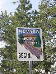
Nevada Scenic Byways
Encyclopedia
U.S. state
A U.S. state is any one of the 50 federated states of the United States of America that share sovereignty with the federal government. Because of this shared sovereignty, an American is a citizen both of the federal entity and of his or her state of domicile. Four states use the official title of...
of Nevada
Nevada
Nevada is a state in the western, mountain west, and southwestern regions of the United States. With an area of and a population of about 2.7 million, it is the 7th-largest and 35th-most populous state. Over two-thirds of Nevada's people live in the Las Vegas metropolitan area, which contains its...
. Currently there are 19 designated state scenic byways. Some of these overlap the three National Scenic Byway
National Scenic Byway
A National Scenic Byway is a road recognized by the United States Department of Transportation for its archeological, cultural, historic, natural, recreational, and/or scenic qualities. The program was established by Congress in 1991 to preserve and protect the nation's scenic but often...
s that have been designated in Nevada.
Federally designated scenic byways
| Name | From | To | Highways | Notes |
|---|---|---|---|---|
| Lake Tahoe - Eastshore Drive | Stateline Stateline, Nevada -Demographics:As of the census of 2000, there were 1,215 people, 510 households, and 245 families residing in the CDP. The population density was 1,803.3 people per square mile . There were 562 housing units at an average density of 834.1 per square mile... |
Incline Village | US 50, SR 28 Nevada State Route 28 State Route 28 is a road that runs along the northeastern shore of Lake Tahoe. The road has been designated as the north piece of the Lake Tahoe–Eastshore Drive Scenic Byway as part of the National Scenic Byway program... |
National Scenic Byway National Scenic Byway A National Scenic Byway is a road recognized by the United States Department of Transportation for its archeological, cultural, historic, natural, recreational, and/or scenic qualities. The program was established by Congress in 1991 to preserve and protect the nation's scenic but often... |
| Lamoille Canyon Road | SR 227 Nevada State Route 227 State Route 227, commonly known as Lamoille Highway, is a state highway in Elko County, in northeastern Nevada in the western United States. From its terminus with State Route 535, it connects the city of Elko with the nearby communities of Spring Creek and Lamoille, to the southeast. For most... at Lamoille Lamoille, Nevada Lamoille is a rural unincorporated community in Elko County in the northeastern section of the state of Nevada in the western United States. It is located about east of Elko at the base of the Ruby Mountains at an elevation of and is part of the Elko Micropolitan Statistical Area.The early... |
Ruby Mountains Ruby Mountains The Ruby Mountains comprise one of the many mountain ranges of the Great Basin in the western United States. They are the predominant range in Elko County, in the northeastern section of the state of Nevada. To the north is Secret Pass and the East Humboldt Range, and from there the Rubies run... |
USDA Forest Service Byway | |
| Las Vegas Strip Las Vegas Strip The Las Vegas Strip is an approximately stretch of Las Vegas Boulevard in Clark County, Nevada; adjacent to, but outside the city limits of Las Vegas proper. The Strip lies within the unincorporated townships of Paradise and Winchester... |
Welcome to Fabulous Las Vegas sign Welcome to Fabulous Las Vegas sign The Welcome to Fabulous Las Vegas sign is a Las Vegas Strip landmark funded in May 1959 and erected soon after by Western Neon. The sign was designed by Betty Willis at the request of Ted Rogich, a local salesman, who sold it to Clark County, Nevada.... |
Sahara Avenue | SR 604 Nevada State Route 604 Las Vegas Boulevard is a major road in Las Vegas Valley of Nevada, best known for the Las Vegas Strip and its casinos. Formerly carrying US 91, the main highway between Los Angeles and Salt Lake City, it has been bypassed by Interstate 15, and serves mainly local traffic with some sections... |
All-American Road (National Scenic Byway National Scenic Byway A National Scenic Byway is a road recognized by the United States Department of Transportation for its archeological, cultural, historic, natural, recreational, and/or scenic qualities. The program was established by Congress in 1991 to preserve and protect the nation's scenic but often... ) |
| Pyramid Lake Scenic Byway | Wadsworth | Pyramid Lake (several termini) | SR 447, SR 446 Nevada State Route 446 State Route 446 , is a state route that runs from SR 445 to SR 447 .... , SR 445 Nevada State Route 445 State Route 445 is a state highway in Washoe County, Nevada. The route follows Pyramid Way, a major thoroughfare in the city of Sparks, and connects the Reno metropolitan area to Pyramid Lake . The route is designated a Nevada Scenic Byway.... |
National Scenic Byway National Scenic Byway A National Scenic Byway is a road recognized by the United States Department of Transportation for its archeological, cultural, historic, natural, recreational, and/or scenic qualities. The program was established by Congress in 1991 to preserve and protect the nation's scenic but often... |
State designated scenic byways
| Name | From | To | Highways | Notes |
|---|---|---|---|---|
| Angel Lake Road | Angel Lake Angel Lake Angel Lake is a glacial tarn in the northern part of the East Humboldt Range, in central Elko County in the northeastern part of the state of Nevada. It is located at approximately , and at an elevation of 8378 feet . It has an area of approximately 13 acres , and a depth of up to 29 feet... |
Wells | SR 231 Nevada State Route 231 Angel Lake Road is a state highway in Elko County, Nevada, USA. It serves to connect Interstate 80 in Wells to nearby Angel Lake in the north of the East Humboldt Range.... |
|
| Baker Road | US 6/US 50 | Utah Utah Utah is a state in the Western United States. It was the 45th state to join the Union, on January 4, 1896. Approximately 80% of Utah's 2,763,885 people live along the Wasatch Front, centering on Salt Lake City. This leaves vast expanses of the state nearly uninhabited, making the population the... |
SR 487 Nevada State Route 487 State Route 487 follows Baker Road, an east–west state highway in White Pine County, Nevada. The State Route designation is applied to the portion of Baker Road from Cattleguard at UT/NV State line to US 6... |
|
| Deer Creek Road | SR 156 | SR 157 | SR 158 Nevada State Route 158 State Route 158 , also known as Deer Creek Road, is a state highway in Clark County, Nevada. The route connects Kyle Canyon Road to Lee Canyon Road in the Spring Mountains, in the Humboldt-Toiyabe National Forest.... |
|
| Gerlach Road | North of Wadsworth | North of Nixon Nixon, Nevada Nixon is a census-designated place in Washoe County, Nevada, USA. The population was 418 at the 2000 census. It is part of the Reno–Sparks Metropolitan Statistical Area... |
SR 447 | Overlaps the Pyramid Lake Scenic Byway |
| Kyle Canyon Road | Mount Charleston Mount Charleston Mount Charleston, officially named Charleston Peak, at , is the highest of the Spring Mountains of southern Nevada and the state's eighth highest mountain peak. It is about northwest of Las Vegas and is within the Humboldt-Toiyabe National Forest, the Mount Charleston Wilderness and the Spring... |
Northwest of Las Vegas | SR 157 Nevada State Route 157 State Route 157 , also known as Kyle Canyon Road, is a state highway in Clark County, Nevada. The highway connects the Las Vegas area to the recreational areas of Mount Charleston in the Spring Mountains.... |
|
| Lehman Caves Road | SR 487 | Great Basin National Park Great Basin National Park Great Basin National Park is a United States National Park established in 1986, located in east-central Nevada near the Utah border. The park derives its name from the Great Basin, the dry and mountainous region between the Sierra Nevada and the Wasatch Mountains. Topographically, this area is... |
SR 488 Nevada State Route 488 State Route 488 is an east–west state highway which covers Lehman Caves Road. The State Route designation is applied to the Lehman Caves Road from the entrance of Great Basin National Park near Lehman Caves Visitor Center Entrance to State Route 487 . It was designated as a Nevada Scenic... |
|
| Mt. Charleston/Lee Canyon Road | Lee Canyon | US 95 | SR 156 Nevada State Route 156 State Route 156 , also known as Lee Canyon Road, is a state highway in Clark County, Nevada. The road is one of two highways connecting U.S... |
|
| Mt. Rose Highway | SR 28 in Incline Village | South of Reno | SR 431 Nevada State Route 431 State Route 431 , commonly known as the Mount Rose Highway, is a 24.4 mile two lane highway in Washoe County, Nevada that connects Incline Village-Crystal Bay at Lake Tahoe with Reno. The highway, a Nevada Scenic Byway, takes its name from Mount Rose, which lies just off the highway... |
Passes by the Mount Rose Wilderness via the highest year-round pass in the Sierra Nevada Sierra Nevada (US) The Sierra Nevada is a mountain range in the U.S. states of California and Nevada, between the California Central Valley and the Basin and Range Province. The Sierra runs north-to-south, and is approximately across east-to-west... at 8911 feet (2,716 m) |
| North Las Vegas Strip | Sahara Avenue | Washington Avenue | SR 604 Nevada State Route 604 Las Vegas Boulevard is a major road in Las Vegas Valley of Nevada, best known for the Las Vegas Strip and its casinos. Formerly carrying US 91, the main highway between Los Angeles and Salt Lake City, it has been bypassed by Interstate 15, and serves mainly local traffic with some sections... |
|
| North Shore Road North Shore Road North Shore Road may mean:*Nevada State Route 28, along the north shore of Lake Tahoe*an unfinished road along the north shore of Fontana Lake, within Great Smoky Mountains National Park in North Carolina... |
US 50 | California California California is a state located on the West Coast of the United States. It is by far the most populous U.S. state, and the third-largest by land area... |
SR 28 Nevada State Route 28 State Route 28 is a road that runs along the northeastern shore of Lake Tahoe. The road has been designated as the north piece of the Lake Tahoe–Eastshore Drive Scenic Byway as part of the National Scenic Byway program... |
Overlaps the Lake Tahoe - Eastshore Drive |
| Pyramid Lake Road | Pyramid Lake Indian Reservation Pyramid Lake Indian Reservation The Pyramid Lake Indian Reservation is a United States reservation in northwestern Nevada ~approximately northeast of Reno, in Washoe, Storey, and Lyon Counties. It lies almost entirely in Washoe County , with but tiny amounts of land in the other two counties . It is governed by the Pyramid Lake... boundary |
Warrior Point | SR 445 Nevada State Route 445 State Route 445 is a state highway in Washoe County, Nevada. The route follows Pyramid Way, a major thoroughfare in the city of Sparks, and connects the Reno metropolitan area to Pyramid Lake . The route is designated a Nevada Scenic Byway.... |
Overlaps the Pyramid Lake Scenic Byway |
| Red Rock Road | Red Rock Canyon National Conservation Area Red Rock Canyon National Conservation Area Red Rock Canyon National Conservation Area in Nevada is an area managed by the Bureau of Land Management as part of its National Landscape Conservation System, and protected as a National Conservation Area. It is located about west of Las Vegas, and easily seen from the Las Vegas Strip... |
SR 159 Nevada State Route 159 State Route 159 is a east–west highway in southern Nevada, providing access to Red Rock Canyon and serving as a thoroughfare in the Las Vegas metropolitan area. A portion of the west end of the route is designated a Nevada Scenic Byway.... |
||
| South Las Vegas Strip | Russell Road Russell Road Russell Road may refer to one of the following:*Russell Road , Canada*Russell Road , Australia*Russell Road , California*Russell Road... |
Sahara Avenue | SR 604 Nevada State Route 604 Las Vegas Boulevard is a major road in Las Vegas Valley of Nevada, best known for the Las Vegas Strip and its casinos. Formerly carrying US 91, the main highway between Los Angeles and Salt Lake City, it has been bypassed by Interstate 15, and serves mainly local traffic with some sections... |
Overlaps the Las Vegas Strip Las Vegas Strip The Las Vegas Strip is an approximately stretch of Las Vegas Boulevard in Clark County, Nevada; adjacent to, but outside the city limits of Las Vegas proper. The Strip lies within the unincorporated townships of Paradise and Winchester... |
| Sutcliffe/Nixon Road | SR 445 | SR 447 | SR 446 Nevada State Route 446 State Route 446 , is a state route that runs from SR 445 to SR 447 .... |
Overlaps the Pyramid Lake Scenic Byway |
| Valley of Fire Road | Valley of Fire State Park | |||
| White Domes Road | Valley of Fire Road | White Domes | ||
| US 50 | California California California is a state located on the West Coast of the United States. It is by far the most populous U.S. state, and the third-largest by land area... |
Carson City | US 50 | Overlaps the Lake Tahoe - Eastshore Drive |
| US 50/6/93 | South of Ely | Utah Utah Utah is a state in the Western United States. It was the 45th state to join the Union, on January 4, 1896. Approximately 80% of Utah's 2,763,885 people live along the Wasatch Front, centering on Salt Lake City. This leaves vast expanses of the state nearly uninhabited, making the population the... |
US 50/US 6/US 93 | |
| US 93 | SR 318 | US 6/US 50 | US 93 | |