

Nevada State Route 157
Encyclopedia
State Route 157 also known as Kyle Canyon Road, is a state highway in Clark County
, Nevada
. The highway connects the Las Vegas
area to the recreational areas of Mount Charleston
in the Spring Mountains
.
Located in the Humboldt-Toiyabe National Forest
, a portion of SR 157 has been designated a Nevada Scenic Byway. The route was originally State Route 39, and has origins dating back to the 1930s.
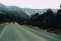 State Route 157 is located 15 miles (24 km) north of Las Vegas
. The route starts at its junction with U.S. Route 95 (US 95) where it heads west rapidly gaining elevation. Within a span of 20 miles (32 km) an elevation of 3000 feet (900 m) is gained with noticeable difference: temperatures drop, trees and shrubs become greener and more numerous and there is lasting snow cover during winter months. Part of the route is designated as a Nevada Scenic Byway
. The highway's western terminus is past the village of Mount Charleston
where it winds up the side of the mountain for a short distance before U-turning back.
 Kyle Canyon Road has existed since at least 1933, having been established as a county road connecting Charleston Peak (in what was then Dixie National Forest
) to State Route 5 (now US 95) at Tule
to the east. By 1935, the entire 21 miles (33.8 km) of the highway had been paved and designated as State Route 39 by the state.
SR 39 appears to remained unchanged for several years after being included in the state highway system. Its first major change occurred on July 1, 1976, when the route was renumbered to State Route 157 in the mass renumbering of Nevada's state highways. This change was first reflected on official state maps in 1978.
In July 1998, the Nevada Department of Transportation
designated SR 157 as a Nevada Scenic Byway. The scenic route encompasses the westernmost 13 miles (20.9 km) of the highway within the national forest area.
Clark County, Nevada
-Demographics:As of the census of 2000, there were 1,375,765 people, 512,253 households, and 339,693 families residing within the MSA. The racial makeup of the MSA was 71.6% White , 9.1% Black, 5.7% Asian, 0.8% American Indian and 12.8% of other or mixed race. 22.0% were Hispanic of any race...
, Nevada
Nevada
Nevada is a state in the western, mountain west, and southwestern regions of the United States. With an area of and a population of about 2.7 million, it is the 7th-largest and 35th-most populous state. Over two-thirds of Nevada's people live in the Las Vegas metropolitan area, which contains its...
. The highway connects the Las Vegas
Las Vegas, Nevada
Las Vegas is the most populous city in the U.S. state of Nevada and is also the county seat of Clark County, Nevada. Las Vegas is an internationally renowned major resort city for gambling, shopping, and fine dining. The city bills itself as The Entertainment Capital of the World, and is famous...
area to the recreational areas of Mount Charleston
Mount Charleston
Mount Charleston, officially named Charleston Peak, at , is the highest of the Spring Mountains of southern Nevada and the state's eighth highest mountain peak. It is about northwest of Las Vegas and is within the Humboldt-Toiyabe National Forest, the Mount Charleston Wilderness and the Spring...
in the Spring Mountains
Spring Mountains
The Spring Mountains are a mountain range of southern Nevada in the United States, running generally northwest-southeast along the west side of Las Vegas and down to the border with California...
.
Located in the Humboldt-Toiyabe National Forest
Humboldt-Toiyabe National Forest
The Humboldt-Toiyabe National Forest is the principal U.S. National Forest located in the U.S. state of Nevada. With an area of , it is the largest National Forest of the United States outside of Alaska...
, a portion of SR 157 has been designated a Nevada Scenic Byway. The route was originally State Route 39, and has origins dating back to the 1930s.
Route description
Las Vegas, Nevada
Las Vegas is the most populous city in the U.S. state of Nevada and is also the county seat of Clark County, Nevada. Las Vegas is an internationally renowned major resort city for gambling, shopping, and fine dining. The city bills itself as The Entertainment Capital of the World, and is famous...
. The route starts at its junction with U.S. Route 95 (US 95) where it heads west rapidly gaining elevation. Within a span of 20 miles (32 km) an elevation of 3000 feet (900 m) is gained with noticeable difference: temperatures drop, trees and shrubs become greener and more numerous and there is lasting snow cover during winter months. Part of the route is designated as a Nevada Scenic Byway
Nevada Scenic Byways
In 1983, a system of scenic byways was established in the U.S. state of Nevada. Currently there are 19 designated state scenic byways. Some of these overlap the three National Scenic Byways that have been designated in Nevada.-Federally designated scenic byways:...
. The highway's western terminus is past the village of Mount Charleston
Mount Charleston, Nevada
Mount Charleston is an unincorporated town in Clark County, Nevada, United States. The population was 285 at the 2000 census.Named for Mount Charleston, the highest point in the area, the town is in a valley of the Spring Mountains to the northwest of Las Vegas, noted for its hiking trails, and for...
where it winds up the side of the mountain for a short distance before U-turning back.
History
Dixie National Forest
Dixie National Forest is a United States National Forest in Utah with headquarters in Cedar City. It occupies almost two million acres and stretches for about 170 miles across southern Utah. The largest national forest in Utah, it straddles the divide between the Great Basin and the Colorado River...
) to State Route 5 (now US 95) at Tule
Tule Springs
Tule Springs in Las Vegas, Nevada, is one of the larger urban retreats in the Las Vegas Valley. It is a significant desert ecosystem consisting of a series of small lakes that formed an oasis in this part of the Mojave Desert...
to the east. By 1935, the entire 21 miles (33.8 km) of the highway had been paved and designated as State Route 39 by the state.
SR 39 appears to remained unchanged for several years after being included in the state highway system. Its first major change occurred on July 1, 1976, when the route was renumbered to State Route 157 in the mass renumbering of Nevada's state highways. This change was first reflected on official state maps in 1978.
In July 1998, the Nevada Department of Transportation
Nevada Department of Transportation
The Nevada Department of Transportation is a government agency in the U.S. state of Nevada. NDOT is responsible for maintaining and improving Nevada's highway system, which includes U.S. highways and Interstate highways within the state's boundaries. The department is notable for its...
designated SR 157 as a Nevada Scenic Byway. The scenic route encompasses the westernmost 13 miles (20.9 km) of the highway within the national forest area.