

Nevada State Route 159
Encyclopedia
State Route 159 is a 31.007 miles (49.9 km) east–west highway in southern Nevada
, providing access to Red Rock Canyon and serving as a thoroughfare in the Las Vegas metropolitan area
. A portion of the west end of the route is designated a Nevada Scenic Byway
.
towards Spring Mountain Ranch State Park
. From there, the highway curves northeast around Red Rock Canyon
to the Las Vegas city limits west of the Las Vegas Beltway. This segment of SR 159 is known on maps and signs as Blue Diamond Road (assuming the name from SR 160), but is also referred to as Red Rock Canyon Road.
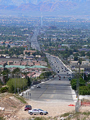
As SR 159 enters the city of Las Vegas, it transitions into Charleston Boulevard, a major east–west section line arterial bisecting the Las Vegas Valley. The highway crosses the Las Vegas Beltway and runs through the planned community of Summerlin. SR 159 continues east to intersect Interstate 15 and then passes south of Downtown Las Vegas
. From there, the highway ventures further east to intersect Interstate 515 and U.S. Routes 93 and 95 before reaching its terminus at Nellis Boulevard (SR 612). (Charleston Boulevard itself ends about three miles (5 km) east of Nellis Boulevard near Frenchman Mountain
.)
 A portion of Charleston Boulevard was previously designated U.S. Route 95 Alternate
to bypass downtown Las Vegas. The designation began at Fremont Street (SR 582) and continued west to Rancho Drive (SR 599), where it curved north to reconnect to US 95. The alternate route was discontinued in 1982.
Approximately 8.8 miles (14.2 km) of SR 159 in Red Rock Canyon was designated a Nevada Scenic Byway on June 30, 1995.
Nevada
Nevada is a state in the western, mountain west, and southwestern regions of the United States. With an area of and a population of about 2.7 million, it is the 7th-largest and 35th-most populous state. Over two-thirds of Nevada's people live in the Las Vegas metropolitan area, which contains its...
, providing access to Red Rock Canyon and serving as a thoroughfare in the Las Vegas metropolitan area
Las Vegas metropolitan area
The Las Vegas Valley is the heart of the Las Vegas-Paradise, NV MSA also known as the Las Vegas–Paradise–Henderson MSA which includes all of Clark County, Nevada, and is a metropolitan area in the southern part of the U.S. state of Nevada. The Valley is defined by the Las Vegas Valley landform, a ...
. A portion of the west end of the route is designated a Nevada Scenic Byway
Nevada Scenic Byways
In 1983, a system of scenic byways was established in the U.S. state of Nevada. Currently there are 19 designated state scenic byways. Some of these overlap the three National Scenic Byways that have been designated in Nevada.-Federally designated scenic byways:...
.
Route description
State Route 159 has two distinct segments. The first segment is a rural two-lane highway that begins at its junction with SR 160. The highway proceeds northwest through the town of Blue DiamondBlue Diamond, Nevada
Blue Diamond is a census-designated place in Clark County, Nevada, United States. The population was 282 at the 2000 census.-Geography:Blue Diamond is located at .-Demographics:...
towards Spring Mountain Ranch State Park
Spring Mountain Ranch State Park
Spring Mountain Ranch State Park is a state park of Nevada, USA, preserving the historic Sandstone Ranch established in 1876. It is located within the Red Rock Canyon National Conservation Area in the Cottonwood Valley, west of Las Vegas. It has a picnic area and a summer theater program through...
. From there, the highway curves northeast around Red Rock Canyon
Red Rock Canyon National Conservation Area
Red Rock Canyon National Conservation Area in Nevada is an area managed by the Bureau of Land Management as part of its National Landscape Conservation System, and protected as a National Conservation Area. It is located about west of Las Vegas, and easily seen from the Las Vegas Strip...
to the Las Vegas city limits west of the Las Vegas Beltway. This segment of SR 159 is known on maps and signs as Blue Diamond Road (assuming the name from SR 160), but is also referred to as Red Rock Canyon Road.
As SR 159 enters the city of Las Vegas, it transitions into Charleston Boulevard, a major east–west section line arterial bisecting the Las Vegas Valley. The highway crosses the Las Vegas Beltway and runs through the planned community of Summerlin. SR 159 continues east to intersect Interstate 15 and then passes south of Downtown Las Vegas
Downtown Las Vegas
Downtown Las Vegas is the central business district of Las Vegas, Nevada. It is the original gambling district of Las Vegas, prior to the Strip, and the area still incorporates downtown gaming.-Tourism:...
. From there, the highway ventures further east to intersect Interstate 515 and U.S. Routes 93 and 95 before reaching its terminus at Nellis Boulevard (SR 612). (Charleston Boulevard itself ends about three miles (5 km) east of Nellis Boulevard near Frenchman Mountain
Frenchman Mountain
Frenchman Mountain is located east of Las Vegas in the U.S. state of Nevada. It is not part of any mountain range. Made up of rocks similar to those found on the bottom of the Grand Canyon, Frenchman Mountain formed when faulting elevated it, giving it its sharp triangulated slope. It is the site...
.)
History
U.S. Route 95 Alternate (Las Vegas, Nevada)
U.S. Route 95 Alternate was an alternate route of U.S. Route 95 in Las Vegas, Nevada that provided a bypass of the downtown area...
to bypass downtown Las Vegas. The designation began at Fremont Street (SR 582) and continued west to Rancho Drive (SR 599), where it curved north to reconnect to US 95. The alternate route was discontinued in 1982.
Approximately 8.8 miles (14.2 km) of SR 159 in Red Rock Canyon was designated a Nevada Scenic Byway on June 30, 1995.