

Nevada State Route 158
Encyclopedia
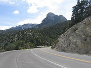
State Route 158 also known as Deer Creek Road, is a state highway
in Clark County
, Nevada
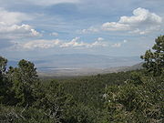
. The route connects Kyle Canyon Road to Lee Canyon Road in the Spring Mountains
, in the Humboldt-Toiyabe National Forest
.
State Route 158 is a designated a Nevada Scenic Byway
.
) east of Mount Charleston
. Heading north as the Deer Creek Road, SR 158 parallels the Humboldt-Toiyabe National Forest
boundary before entering the park. The highway ends at a junction with Lee Canyon Road (SR 156
).
designated State Route 156 as a Nevada Scenic Byway in July 1998. The "Deer Creek Road" scenic route encompasses the entire 8.8 miles (14.2 km) highway.
State highway
State highway, state road or state route can refer to one of three related concepts, two of them related to a state or provincial government in a country that is divided into states or provinces :#A...
in Clark County
Clark County, Nevada
-Demographics:As of the census of 2000, there were 1,375,765 people, 512,253 households, and 339,693 families residing within the MSA. The racial makeup of the MSA was 71.6% White , 9.1% Black, 5.7% Asian, 0.8% American Indian and 12.8% of other or mixed race. 22.0% were Hispanic of any race...
, Nevada
Nevada
Nevada is a state in the western, mountain west, and southwestern regions of the United States. With an area of and a population of about 2.7 million, it is the 7th-largest and 35th-most populous state. Over two-thirds of Nevada's people live in the Las Vegas metropolitan area, which contains its...
. The route connects Kyle Canyon Road to Lee Canyon Road in the Spring Mountains
Spring Mountains
The Spring Mountains are a mountain range of southern Nevada in the United States, running generally northwest-southeast along the west side of Las Vegas and down to the border with California...
, in the Humboldt-Toiyabe National Forest
Humboldt-Toiyabe National Forest
The Humboldt-Toiyabe National Forest is the principal U.S. National Forest located in the U.S. state of Nevada. With an area of , it is the largest National Forest of the United States outside of Alaska...
.
State Route 158 is a designated a Nevada Scenic Byway
Nevada Scenic Byways
In 1983, a system of scenic byways was established in the U.S. state of Nevada. Currently there are 19 designated state scenic byways. Some of these overlap the three National Scenic Byways that have been designated in Nevada.-Federally designated scenic byways:...
.
Route description
The route begins at an intersection with Kyle Canyon Road (SR 157Nevada State Route 157
State Route 157 , also known as Kyle Canyon Road, is a state highway in Clark County, Nevada. The highway connects the Las Vegas area to the recreational areas of Mount Charleston in the Spring Mountains....
) east of Mount Charleston
Mount Charleston, Nevada
Mount Charleston is an unincorporated town in Clark County, Nevada, United States. The population was 285 at the 2000 census.Named for Mount Charleston, the highest point in the area, the town is in a valley of the Spring Mountains to the northwest of Las Vegas, noted for its hiking trails, and for...
. Heading north as the Deer Creek Road, SR 158 parallels the Humboldt-Toiyabe National Forest
Humboldt-Toiyabe National Forest
The Humboldt-Toiyabe National Forest is the principal U.S. National Forest located in the U.S. state of Nevada. With an area of , it is the largest National Forest of the United States outside of Alaska...
boundary before entering the park. The highway ends at a junction with Lee Canyon Road (SR 156
Nevada State Route 156
State Route 156 , also known as Lee Canyon Road, is a state highway in Clark County, Nevada. The road is one of two highways connecting U.S...
).
History
The Nevada Department of TransportationNevada Department of Transportation
The Nevada Department of Transportation is a government agency in the U.S. state of Nevada. NDOT is responsible for maintaining and improving Nevada's highway system, which includes U.S. highways and Interstate highways within the state's boundaries. The department is notable for its...
designated State Route 156 as a Nevada Scenic Byway in July 1998. The "Deer Creek Road" scenic route encompasses the entire 8.8 miles (14.2 km) highway.