

National Register of Historic Places listings in Northern Chester County, Pennsylvania
Encyclopedia
File:Map of Chester County Pennsylvania NRHP sites.PNG|thumb|right|Map of Chester County (clickable)
poly 230 136 258 125 257 120 300 64 302 62 309 57 313 57 310 63 308 65 308 69 309 70 312 73 318 77 320 75 323 75 328 75 330 79 330 83 328 85 328 89 331 91 331 95 334 100 341 98 352 96 364 117 378 111 381 113 355 129 359 138 338 159 342 160 342 164 303 190 302 195 300 196 302 204 296 199 294 202 293 202 293 205 289 207 289 211 282 216 278 212 271 214 261 201 264 196 Eastern
poly 180 329 183 320 198 295 222 274 248 261 264 257 268 249 264 245 267 243 267 239 264 234 270 229 276 226 279 222 279 218 283 216 279 213 270 213 261 199 264 196 238 152 230 154 225 155 220 158 215 159 211 157 206 157 192 161 192 165 179 165 79 194 77 199 73 201 72 205 72 211 72 214 75 222 74 226 75 233 75 237 70 234 67 238 66 245 61 247 60 259 58 261 55 268 53 263 56 270 53 270 51 276 51 279 48 280 48 287 46 292 42 294 41 296 38 299 40 301 38 306 31 305 30 312 27 314 22 315 24 322 19 329 15 326 15 321 12 321 12 327 9 327 5 327 5 329 25 330 Southern
National Register of Historic Places listings in Southern Chester County, Pennsylvania
File:Map of Chester County Pennsylvania NRHP sites.PNG|thumb|right|Map of Chester County poly 77 194 71 185 77 176 100 130 101 113 100 100 97 89 128 71 187 24 216 5 222 7 229 4 237 3 253 11 258 15 262 13 262 9 264 8 277 32 278 34 282 33 281 30 282 26 286 26 289 35 291 43 300 50 300 55 298 58 299 63...
desc none
This is a list of the National Register of Historic Places listings in Northern Chester County, Pennsylvania.
This is intended to be a complete list of the properties and districts on the National Register of Historic Places
National Register of Historic Places
The National Register of Historic Places is the United States government's official list of districts, sites, buildings, structures, and objects deemed worthy of preservation...
in northern Chester County
Chester County, Pennsylvania
-State parks:*French Creek State Park*Marsh Creek State Park*White Clay Creek Preserve-Demographics:As of the 2010 census, the county was 85.5% White, 6.1% Black or African American, 0.2% Native American or Alaskan Native, 3.9% Asian, 0.0% Native Hawaiian, 1.8% were two or more races, and 2.4% were...
, Pennsylvania
Pennsylvania
The Commonwealth of Pennsylvania is a U.S. state that is located in the Northeastern and Mid-Atlantic regions of the United States. The state borders Delaware and Maryland to the south, West Virginia to the southwest, Ohio to the west, New York and Ontario, Canada, to the north, and New Jersey to...
, United States
United States
The United States of America is a federal constitutional republic comprising fifty states and a federal district...
. Northern Chester County is defined as being the municipalities north of the Pennsylvania Main Line
Pennsylvania Main Line
The Main Line is an unofficial historical and socio-cultural region of suburban Philadelphia, Pennsylvania, comprising a collection of affluent towns built along the old Main Line of the Pennsylvania Railroad which ran northwest from downtown Philadelphia parallel to Lancaster Avenue , a road...
and west of a line extending from Phoenixville
Phoenixville, Pennsylvania
Phoenixville is a borough in Chester County, Pennsylvania, United States, northwest of Philadelphia, at the junction of French Creek with the Schuylkill River. The population is 16,440 as of the 2010 Census.- History :...
to Exton
Exton, Pennsylvania
Exton is a census-designated place in West Whiteland Township, Chester County, Pennsylvania, United States. Its population was 4,842 at the 2010 census. The Exton Square Mall is located within Exton along with several other shopping centers, making Exton the major shopping district in Chester...
. The locations of National Register properties and districts for which the latitude and longitude coordinates are included below, may be seen in a Google map.
There are 310 properties and districts listed on the Register in Chester County, including 7 National Historic Landmark
National Historic Landmark
A National Historic Landmark is a building, site, structure, object, or district, that is officially recognized by the United States government for its historical significance...
s. Northern Chester County includes 83 properties and districts, including 2 National Historic Landmarks; the county's remaining properties and districts are listed elsewhere
National Register of Historic Places listings in Chester County, Pennsylvania
File:Map of Chester County Pennsylvania NRHP sites.PNG|thumb|right|Map of Chester County poly 77 194 71 185 77 176 100 130 101 113 100 100 97 89 128 71 187 24 216 5 222 7 229 4 237 3 253 11 258 15 262 13 262 9 264 8 277 32 278 34 282 33 281 30 282 26 286 26 289 35 291 43 300 50 300 55 298 58 299 63...
. One district, the Middle Pickering Rural Historic District, is split between Northern and Eastern Chester County, and is thus included on both lists.
Current listings
| Landmark name | Image | Date listed | Location | City or Town | Summary | |
|---|---|---|---|---|---|---|
| 1 | 822–824 East Chestnut Street 39°59′12.7"N 75°48′28.8"W |
Coatesville Coatesville, Pennsylvania Coatesville is the only city in Chester County, Pennsylvania, United States. The population was 13,100 at the 2010 census. Coatesville is approximately 39 miles west of Philadelphia.... |
||||
| 2 | Birchrunville General Store | Hollow and Flowing Springs Roads, at Birchrunville 40°7′51"N 75°38′26"W |
West Vincent Township | |||
| 3 | Birchrunville Historic District | Junction of Flowing Springs Road and Schoolhouse Ln. near Birchrunville 40°7′56"N 75°38′19"W |
West Vincent Township | |||
| 4 | Bridge Mill Farm | Marshall Road near Downingtown 40°3′22"N 75°45′35"W |
East Brandywine Township | |||
| 5 | Brower's Bridge | Mansion Road over French Creek 40°8′51"N 75°46′10"W |
Warwick Township Warwick Township, Chester County, Pennsylvania Warwick Township is a township in Chester County, Pennsylvania, United States. The population was 2,507 at the 2010 census.-Geography:According to the United States Census Bureau, the township has a total area of , all of it land.-Demographics:... |
|||
| 6 | East of Elverson on Bulltown Road 40°9′3"N 75°47′34"W |
East Nantmeal Township | ||||
| 7 | Byers Station Historic District | Junction of Byers and Eagle Farm Roads 40°4′48"N 75°40′30"W |
Upper Uwchlan Township | |||
| 8 | Caln Meeting House Caln Meeting House Caln Meeting House is a historic Quaker meeting house at 901 Caln Meeting House Road, Caln Township in Coatesville, Pennsylvania.It was built in 1726 and added to the National Register in 1984. Services are still held weekly at the meeting house.... |
901 Caln Meeting House Road near Coatesville 40°0′26"N 75°45′55"W |
Caln Township | |||
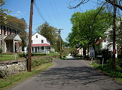
| 9 | Chester Springs Historic District | North of Chester Springs on Art School Road 40°5′45"N 75°37′24"W |
West Pikeland Township | |||
| 10 | Clinger-Moses Mill Complex | South of Chester Springs on Pine Creek Lane 40°4′58"N 75°36′49"W |
West Pikeland Township | |||
| 11 | Coatesville Historic District | Roughly bounded by Chestnut Street, 6th Avenue, Oak Street, 5th Avenue, Harmony Street, and 1st Avenue 39°58′57"N 75°49′4"W |
Coatesville Coatesville, Pennsylvania Coatesville is the only city in Chester County, Pennsylvania, United States. The population was 13,100 at the 2010 census. Coatesville is approximately 39 miles west of Philadelphia.... |
|||
| 12 | County Bridge No. 101 | Wagontown Road over Brandywine Creek, near Rock Run 39°59′29"N 75°49′52"W |
Valley Township Valley Township, Chester County, Pennsylvania Valley Township is a township in Chester County, Pennsylvania, United States. The population was 6,794 at the 2010 census.-Geography:According to the United States Census Bureau, the township has a total area of , of which 0.17% is water.-Demographics:... |
|||
| 13 | County Bridge No. 124 | Edge Hill Road over Beaver Creek 40°0′38"N 75°44′39"W |
Downingtown Downingtown, Pennsylvania Downingtown is a borough in Chester County, Pennsylvania, west of Philadelphia. As of the 2010 census it had a population of 7,891. Downingtown was settled by English and European colonists in the early 18th century and has a number of historic buildings and structures.-History:The town was... |
|||
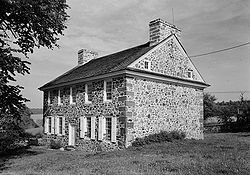
| 14 | Coventry Hall |  |
Off Pennsylvania Route 23 Pennsylvania Route 23 Pennsylvania Route 23 is a state highway in southeastern Pennsylvania. The route begins at Pennsylvania Route 441 in Marietta and heads east to U.S. Route 1 in Philadelphia.-Marietta to Valley Forge:... 40°10′30"N 75°41′14"W |
South Coventry Township | ||
| 15 | Coventryville Historic District Coventryville Historic District The Coventryville Historic District is a historic district and historic village in Chester County, Pennsylvania that occupied a significant role in the early American metal industry.-History:... |
 |
South of Pottstown on Pennsylvania Route 23 Pennsylvania Route 23 Pennsylvania Route 23 is a state highway in southeastern Pennsylvania. The route begins at Pennsylvania Route 441 in Marietta and heads east to U.S. Route 1 in Philadelphia.-Marietta to Valley Forge:... 40°10′12"N 75°41′32"W |
South Coventry Township | ||
| 16 | Deery Family Homestead | West of Phoenixville 40°6′47"N 75°36′32"W |
West Vincent Township | |||
| 17 | Downingtown Log House | 15 East Lancaster Avenue 40°0′23"N 75°42′18"W |
Downingtown Downingtown, Pennsylvania Downingtown is a borough in Chester County, Pennsylvania, west of Philadelphia. As of the 2010 census it had a population of 7,891. Downingtown was settled by English and European colonists in the early 18th century and has a number of historic buildings and structures.-History:The town was... |
|||
| 18 | East Lancaster Avenue Historic District | An irregular pattern along East Lancaster Avenue 40°0′36"N 75°41′47"W |
Downingtown Downingtown, Pennsylvania Downingtown is a borough in Chester County, Pennsylvania, west of Philadelphia. As of the 2010 census it had a population of 7,891. Downingtown was settled by English and European colonists in the early 18th century and has a number of historic buildings and structures.-History:The town was... |
|||
| 19 | Nicholas East House | West of Valley Forge on Kimberton Road 40°6′49"N 75°39′16"W |
West Vincent Township | |||
| 20 | Elverson Historic District | Main, Chestnut and Hall Streets and Park Avenue 40°9′24"N 75°49′56"W |
Elverson Elverson, Pennsylvania Elverson is a borough in Chester County, Pennsylvania, United States. The population was 1,225 at the 2010 census.Settled near the region's early iron mines, Elverson is close to Hopewell Furnace National Historic Site, an example of a 19th century "iron plantation".-History:Elverson's earliest... |
|||
| 21 | Fagley House | West of Phoenixville on Art School Road 40°6′30"N 75°36′45"W |
West Pikeland Township | |||
| 22 | William Ferguson Farm | East of Glen Moore on Marshall Road 40°4′57"N 75°44′58"W |
Wallace Township | |||
| 23 | French Creek Farm | Kimberton Road near Kimberton 40°8′12"N 75°35′14"W |
East Pikeland Township | |||
| 24 | Fricks Locks Historic District | End of Fricks Lock Road, approximately 1000 feet east of Sanatoga Road 40°13′21"N 75°35′47"W |
East Coventry Township | |||
| 25 | General Washington Inn | Uwchlan and East Lancaster Avenues 40°0′41"N 75°41′45"W |
Downingtown Downingtown, Pennsylvania Downingtown is a borough in Chester County, Pennsylvania, west of Philadelphia. As of the 2010 census it had a population of 7,891. Downingtown was settled by English and European colonists in the early 18th century and has a number of historic buildings and structures.-History:The town was... |
|||
| 26 | Glenmoore Historic District | Junction of Fairview and Creek Roads; roughly bounded by Park Lane, Indiantown Road, and Howson Lane 40°5′31.5"N 75°46′31.4"W |
Wallace Township | |||
| 27 | Hall's Bridge | About 3 miles (4.8 km) north of Chester Springs at Sheeder Road and Birch Run 40°8′51"N 75°37′15"W |
East and West Vincent Townships | |||
| 28 | Hare's Hill Road Bridge Hares Hill Road Bridge The Hares Hill Road Bridge is a single-span, wrought iron, arched-shaped lattice girder bridge. It was built in 1869 in Chester County, Pennsylvania by Moseley Iron Bridge and Roof Company and is the only known surviving example of this kind. The bridge crosses French Creek, a Scenic River, and... |
 |
West of Phoenixville on Hare's Hill Road 40°8′27"N 75°34′6"W |
East Pikeland Township | ||
| 29 | George Hartman House | West of Phoenixville on Church Road 40°6′13"N 75°35′32"W |
East Pikeland Township | |||
| 30 | Hatfield-Hibernia Historic District | North of Wagontown 40°1′24"N 75°50′46"W |
West Caln Township | |||
| 31 | Hibernia House | North of Wagontown off Pennsylvania Route 340 Pennsylvania Route 340 Pennsylvania Route 340 is a long state highway located in Lancaster and Chester counties in Pennsylvania. The western terminus is at Pennsylvania Route 462 in Lancaster. The eastern terminus is at U.S... 40°1′45"N 75°50′33"W |
West Caln Township | |||
| 32 | High Bridge High Bridge (Coatesville, Pennsylvania) The Coatesville High Bridge is a stone masonry arch railroad viaduct that crosses the valley of the West Branch Brandywine Creek at Coatesville, Pennsylvania. Built by the Pennsylvania Railroad between 1902 and 1904, it has ten arches and spans a total length of , with wing walls extending it to... |
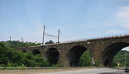 |
Spans west branch of the Brandywine 39°59′2"N 75°49′39"W |
Coatesville Coatesville, Pennsylvania Coatesville is the only city in Chester County, Pennsylvania, United States. The population was 13,100 at the 2010 census. Coatesville is approximately 39 miles west of Philadelphia.... |
||
| 33 | Hockley Mill Farm | Warwick Furnace Road, southeast of Knauertown 40°9′15"N 75°42′59"W |
Warwick Township Warwick Township, Chester County, Pennsylvania Warwick Township is a township in Chester County, Pennsylvania, United States. The population was 2,507 at the 2010 census.-Geography:According to the United States Census Bureau, the township has a total area of , all of it land.-Demographics:... |
|||
| 34 | Hopewell Farm | 1751 Valley Road 39°58′1"N 75°52′9"W |
Valley Township Valley Township, Chester County, Pennsylvania Valley Township is a township in Chester County, Pennsylvania, United States. The population was 6,794 at the 2010 census.-Geography:According to the United States Census Bureau, the township has a total area of , of which 0.17% is water.-Demographics:... |
|||
| 35 | Hopewell Furnace National Historic Site Hopewell Furnace National Historic Site Hopewell Furnace National Historic Site in southeastern Berks County, near Elverson, Pennsylvania, is an example of an American 19th century rural "iron plantation"... |
 |
5 miles (8 km) south of Birdsboro, near Pine Swamp 40°12′20"N 75°46′6"W |
Warwick Township Warwick Township, Chester County, Pennsylvania Warwick Township is a township in Chester County, Pennsylvania, United States. The population was 2,507 at the 2010 census.-Geography:According to the United States Census Bureau, the township has a total area of , all of it land.-Demographics:... |
Extends into Berks County | |
| 36 | Roger Hunt Mill | Race Street 40°0′29"N 75°42′41"W |
Downingtown Downingtown, Pennsylvania Downingtown is a borough in Chester County, Pennsylvania, west of Philadelphia. As of the 2010 census it had a population of 7,891. Downingtown was settled by English and European colonists in the early 18th century and has a number of historic buildings and structures.-History:The town was... |
|||
| 37 | Abram Huston House and Carriage House | 53 South 1st Avenue 39°58′54"N 75°49′21"W |
Coatesville Coatesville, Pennsylvania Coatesville is the only city in Chester County, Pennsylvania, United States. The population was 13,100 at the 2010 census. Coatesville is approximately 39 miles west of Philadelphia.... |
|||
| 38 | Isabella Furnace Isabella Furnace Isabella Furnace was a cold blast charcoal iron furnace located in West Nantmeal Township, Chester County, Pennsylvania. The furnace was named for Isabella Potts, wife of one of the partners, a member of the Potts ironmaking family... |
Bollinger Drive just north of Creek Road, near Brandywine Manor 40°6′48"N 75°49′23"W |
West Nantmeal Township | |||
| 39 | Kennedy Bridge | North of Kimberton off Pennsylvania Route 23 Pennsylvania Route 23 Pennsylvania Route 23 is a state highway in southeastern Pennsylvania. The route begins at Pennsylvania Route 441 in Marietta and heads east to U.S. Route 1 in Philadelphia.-Marietta to Valley Forge:... on Seven Stars Road over French Creek 40°8′25"N 75°34′36"W |
East Vincent Township | |||
| 40 | Ker-Feal Ker-Feal Ker-Feal, built in 1775, is a historic fieldstone dwelling located in West Pikeland Township, Chester County, Pennsylvania. It was listed on the National Register of Historic Places on November 7, 2003.... |
1081 Bodine Road, Chester Springs 40°4′38"N 75°36′33"W |
West Pikeland Township | |||
| 41 | Kimberton Village Historic District | Both sides of Hares Hill Road between Kimberton and Cold Stream 40°7′47"N 75°34′36"W |
East Pikeland Township | |||
| 42 | Pennsylvania Route 23 Pennsylvania Route 23 Pennsylvania Route 23 is a state highway in southeastern Pennsylvania. The route begins at Pennsylvania Route 441 in Marietta and heads east to U.S. Route 1 in Philadelphia.-Marietta to Valley Forge:... in Knauertown 40°10′14"N 75°43′53"W |
Warwick Township Warwick Township, Chester County, Pennsylvania Warwick Township is a township in Chester County, Pennsylvania, United States. The population was 2,507 at the 2010 census.-Geography:According to the United States Census Bureau, the township has a total area of , all of it land.-Demographics:... |
||||
| 43 | Lahr Farm | East of Elverson on Pennsylvania Route 23 Pennsylvania Route 23 Pennsylvania Route 23 is a state highway in southeastern Pennsylvania. The route begins at Pennsylvania Route 441 in Marietta and heads east to U.S. Route 1 in Philadelphia.-Marietta to Valley Forge:... 40°9′39"N 75°46′10"W |
Warwick Township Warwick Township, Chester County, Pennsylvania Warwick Township is a township in Chester County, Pennsylvania, United States. The population was 2,507 at the 2010 census.-Geography:According to the United States Census Bureau, the township has a total area of , all of it land.-Demographics:... |
|||
| 44 | Larkin Covered Bridge | North of Downingtown in Marsh Creek State Park Marsh Creek State Park Marsh Creek State Park is a Pennsylvania state park in Upper Uwchlan and Wallace Townships, Chester County, Pennsylvania in the United States. The park is the location of the man-made Marsh Creek Lake. With an average depth of 40 feet , the lake is stocked with fish and is a stop for migrating... 40°4′15"N 75°43′15"W |
Upper Uwchlan Township | |||
| 45 | Lightfoot Mill Lightfoot Mill The Mill at Anselma is an archetypal small, 18th century custom grain mill in Chester Springs, Pennsylvania. It is probably the only surviving one in the United States with an intact colonial-era power transmission system... |
1703 Conestoga Road in Chester Springs 40°4′53"N 75°38′40"W |
West Pikeland Township | |||
| 46 | Lionville Historic District | Roughly along Pennsylvania Route 100 Pennsylvania Route 100 Pennsylvania Route 100 is a state highway in the U.S. state of Pennsylvania that runs from U.S. Route 202 in West Chester, Pennsylvania to Pennsylvania Route 309 in Pleasant Corners, Pennsylvania.... and South Village Avenue in Lionville 40°3′16"N 75°39′33"W |
Uwchlan Township | |||
| 47 | Lukens Historic District Lukens Historic District Lukens Historic District is a historic district in Coatesville, Pennsylvania. Its National Historic Landmark summary listing says:This district is associated with Rebecca Lukens , who played a leading role in the 19th-century American iron industry, and her family legacy... |
50, 53, 76, and 102 South 1st Street 39°58′52"N 75°49′21"W |
Coatesville Coatesville, Pennsylvania Coatesville is the only city in Chester County, Pennsylvania, United States. The population was 13,100 at the 2010 census. Coatesville is approximately 39 miles west of Philadelphia.... |
|||
| 48 | Lukens Main Office Building | 50 South 1st Avenue 39°58′54"N 75°49′25"W |
Coatesville Coatesville, Pennsylvania Coatesville is the only city in Chester County, Pennsylvania, United States. The population was 13,100 at the 2010 census. Coatesville is approximately 39 miles west of Philadelphia.... |
|||
| 49 | Marshall's Bridge | Marshall Road over Culbertson Run 40°3′23"N 75°45′31"W |
East Brandywine Township | |||
| 50 | Simon Meredith House | 0.5 mile (0.80467 km) west of Pughtown on Pughtown Road 40°10′12"N 75°40′39"W |
South Coventry Township | |||
| 51 | Stephen Meredith House | Pennsylvania Route 100 Pennsylvania Route 100 Pennsylvania Route 100 is a state highway in the U.S. state of Pennsylvania that runs from U.S. Route 202 in West Chester, Pennsylvania to Pennsylvania Route 309 in Pleasant Corners, Pennsylvania.... halfway between Bucktown and Pughtown 40°10′17"N 75°39′41"W |
South Coventry Township | |||
| 52 | Nathan Michener House | West of Bucktown on Ridge Road 40°10′25"N 75°40′30"W |
South Coventry Township | |||
| 53 | Middle Pickering Rural Historic District | Pikeland, Yellow Springs, Merlin, Church, and Pickering Roads 40°5′40"N 75°34′38"W |
East and West Pikeland Townships | Extends into Charlestown Township in Eastern Chester County | ||
| 54 | National Bank of Coatesville Building | 235 East Lincoln Highway 39°59′1"N 75°49′19"W |
Coatesville Coatesville, Pennsylvania Coatesville is the only city in Chester County, Pennsylvania, United States. The population was 13,100 at the 2010 census. Coatesville is approximately 39 miles west of Philadelphia.... |
|||
| 55 | North Warwick Historic and Archeological District | Pennsylvania Route 345 Pennsylvania Route 345 Pennsylvania Route 345 is a state highway in the U.S. state of Pennsylvania. The route runs from Pennsylvania Route 82 in West Nantmeal Township, Chester County north to U.S. Route 422 in Birdsboro, Berks County.-Route description:... and Harmonyville, Bethesda, Hopewell, Piersol, Trythall, and Northside Roads 40°11′18"N 75°46′8"W |
Warwick Township Warwick Township, Chester County, Pennsylvania Warwick Township is a township in Chester County, Pennsylvania, United States. The population was 2,507 at the 2010 census.-Geography:According to the United States Census Bureau, the township has a total area of , all of it land.-Demographics:... |
|||
| 56 | Parker's Ford | Old Schuylkill Road near Parkerford 40°11′56"N 75°34′52"W |
East Coventry and East Vincent Townships | |||
| 57 | Parkesburg National Bank | Gay and Main Streets 39°57′35"N 75°55′22"W |
Parkesburg Parkesburg, Pennsylvania Parkesburg is a borough in Chester County, Pennsylvania, United States. The population was 3,593 at the 2010 census. The Zip code is 19365.-History:... |
|||
| 58 | Parkesburg School | 360 Strasburg Avenue 39°57′40"N 75°55′14"W |
Parkesburg Parkesburg, Pennsylvania Parkesburg is a borough in Chester County, Pennsylvania, United States. The population was 3,593 at the 2010 census. The Zip code is 19365.-History:... |
|||
| 59 | Pleasant Hill Plantation Pleasant Hill Plantation Pleasant Hill Plantation is a stone farmhouse located in Glenmoore, Pennsylvania.The original structure of two stories and three bays was built by Matthew Robinson or Robertson, probably before the American Revolution. He died in 1792 and left the house to his son David. Around 1800, it was sold to... |
Little Conestoga Road near Glen Moore 40°7′2"N 75°47′0"W |
West Nantmeal Township | |||
| 60 | Pottstown Landing Historic District | Roughly bounded by U.S. Route 422 U.S. Route 422 U.S. Route 422 is a long spur route of US 22 split into two segments in the U.S. states of Ohio and Pennsylvania. The western spur begins in downtown Cleveland, Ohio, and ends at Ebensburg, Pennsylvania... bypass, Whartnaby Street 633 Laurelwood Road and Reiff Street 40°14′17"N 75°39′51"W |
North Coventry Township | |||
| 61 | Prizer's Mill Complex | West of Phoenixville on Seven Stars Road 40°8′16"N 75°34′27"W |
East Pikeland Township | |||
| 62 | Rapps Bridge | 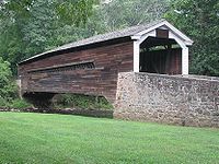 |
West of Mont Clare off Pennsylvania Route 724 Pennsylvania Route 724 Pennsylvania Route 724 is a road spanning from Sinking Spring, Pennsylvania to Phoenixville, Pennsylvania. 724 travels through the counties of Berks and Chester... on Mowere Road 40°8′22"N 75°32′34"W |
East Pikeland Township | ||
| 63 | Reading Furnace Historic District | Mansion Road 40°8′49"N 75°46′8"W |
Warwick Township Warwick Township, Chester County, Pennsylvania Warwick Township is a township in Chester County, Pennsylvania, United States. The population was 2,507 at the 2010 census.-Geography:According to the United States Census Bureau, the township has a total area of , all of it land.-Demographics:... |
|||
| 64 | Rice-Pennebecker Farm | Clover Mill Road near Chester Springs 40°6′7"N 75°35′59"W |
West Pikeland Township | |||
| 65 | River Bend Farm River Bend Farm River Bend Farm is a historic farm located in Chester County, Pennsylvania in a bend of the Schuylkill River near Pottstown. The farm house is a good example of early Chester County construction techniques, being built with stuccoed stone walls and pegged rafters. The farm was owned, but not lived... |
North of Spring City on Sanatoga Road 40°13′47.4"N 75°35′53"W |
East Coventry Township | |||
| 66 | Philip Rogers House | Ridge Road 40°10′29"N 75°43′11"W |
Warwick Township Warwick Township, Chester County, Pennsylvania Warwick Township is a township in Chester County, Pennsylvania, United States. The population was 2,507 at the 2010 census.-Geography:According to the United States Census Bureau, the township has a total area of , all of it land.-Demographics:... |
|||
| 67 | Robert Rooke House | North of Downingtown on Horseshoe Trail at Fellowship Road 40°7′19"N 75°39′42"W |
West Vincent Township | |||
| 68 | St. Mary's Episcopal Church St. Mary's Episcopal Church (Elverson, Pennsylvania) St. Mary's Episcopal Church is a historic church on Warwick Road, Warwick Township in Elverson, Pennsylvania.Founded by Rev. Levi Bull, DD, in 1805, the first church here was built in 1806. J.F. Sachse, of the Historical Society of Pennsylvania, believed it to be the first church built in... |
Warwick Road near Elverson 40°9′57"N 75°46′52"W |
Warwick Township Warwick Township, Chester County, Pennsylvania Warwick Township is a township in Chester County, Pennsylvania, United States. The population was 2,507 at the 2010 census.-Geography:According to the United States Census Bureau, the township has a total area of , all of it land.-Demographics:... |
|||
| 69 | St. Peters Village Historic District Saint Peter's Village Saint Peters is a community located in Chester County, Pennsylvania. The village is a historic 19th century industrial 'company village' at the Falls of French Creek in Warwick Township.... |
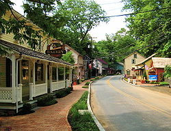 |
Eastern and western sides of St. Peters Road between School Road and Rock Run Road 40°10′51"N 75°43′46"W |
Warwick Township Warwick Township, Chester County, Pennsylvania Warwick Township is a township in Chester County, Pennsylvania, United States. The population was 2,507 at the 2010 census.-Geography:According to the United States Census Bureau, the township has a total area of , all of it land.-Demographics:... |
||
| 70 | Sandy Hill Tavern | Southeast of Honey Brook on Pennsylvania Route 340 Pennsylvania Route 340 Pennsylvania Route 340 is a long state highway located in Lancaster and Chester counties in Pennsylvania. The western terminus is at Pennsylvania Route 462 in Lancaster. The eastern terminus is at U.S... 40°1′0"N 75°53′46"W |
West Caln Township | |||
| 71 | Springton Manor Farm | South of Glenmoore at Springton and Creek Roads 40°4′18"N 75°46′40"W |
Wallace Township | |||
| 72 | Strickland-Roberts Homestead | 3 miles (4.8 km) south of Kimberton on St. Matthews Road 40°7′20"N 75°38′6"W |
West Vincent Township | |||
| 73 | Terracina | 76 South 1st Avenue 39°58′52"N 75°49′21"W |
Coatesville Coatesville, Pennsylvania Coatesville is the only city in Chester County, Pennsylvania, United States. The population was 13,100 at the 2010 census. Coatesville is approximately 39 miles west of Philadelphia.... |
|||
| 74 | Townsend House | Southwest of Pughtown off Pennsylvania Route 100 Pennsylvania Route 100 Pennsylvania Route 100 is a state highway in the U.S. state of Pennsylvania that runs from U.S. Route 202 in West Chester, Pennsylvania to Pennsylvania Route 309 in Pleasant Corners, Pennsylvania.... 40°9′51"N 75°40′21"W |
South Coventry Township | |||
| 75 | Uwchlan Meetinghouse Uwchlan Meetinghouse Uwchlan Meetinghouse is a historic Quaker meeting house on N. Village Avenue in Lionville, Pennsylvania.It was built in 1756 and added to the National Register in 1973.... |
North Village Avenue (Pennsylvania Route 113 Pennsylvania Route 113 Pennsylvania Route 113 is a long state route in eastern Pennsylvania. The southern terminus of the route is at U.S. Route 30 Business in Downingtown. Its northern terminus is at Pennsylvania Route 611 in Tinicum Township... ) in Lionville 40°3′16"N 75°39′37"W |
Uwchlan Township | |||
| 76 | Vincent Forge Mansion | Cook's Glen Road R.D. 40°9′26"N 75°38′29"W |
East Vincent Township | |||
| 77 | Warrenpoint Warrenpoint (Knauertown, Pennsylvania) Warrenpoint is an historic home located in Knauertown, Pennsylvania, in Chester County. The house was built in 1756 in the Georgian Colonial style by William Branson.... |
 |
West of Knauertown off Pennsylvania Route 23 Pennsylvania Route 23 Pennsylvania Route 23 is a state highway in southeastern Pennsylvania. The route begins at Pennsylvania Route 441 in Marietta and heads east to U.S. Route 1 in Philadelphia.-Marietta to Valley Forge:... 40°9′52"N 75°44′37"W |
Warwick Township Warwick Township, Chester County, Pennsylvania Warwick Township is a township in Chester County, Pennsylvania, United States. The population was 2,507 at the 2010 census.-Geography:According to the United States Census Bureau, the township has a total area of , all of it land.-Demographics:... |
||
| 78 | Warwick Furnace/Farms Warwick Furnace Farms Warwick Furnace Farms is a historic district in northern Chester County, Pennsylvania that includes the ruins of an early iron furnace, the ironmaster's house and workers' houses, as well as a historic farm house and barns now used in the operation of a working farm... |
South of Knauertown off Pennsylvania Route 23 Pennsylvania Route 23 Pennsylvania Route 23 is a state highway in southeastern Pennsylvania. The route begins at Pennsylvania Route 441 in Marietta and heads east to U.S. Route 1 in Philadelphia.-Marietta to Valley Forge:... on Warwick Furnace Road 40°9′3"N 75°44′28"W |
East Nantmeal Township | |||
| 79 | Warwick Mills | East of Elverson off Pennsylvania Route 23 Pennsylvania Route 23 Pennsylvania Route 23 is a state highway in southeastern Pennsylvania. The route begins at Pennsylvania Route 441 in Marietta and heads east to U.S. Route 1 in Philadelphia.-Marietta to Valley Forge:... on James Mills Road 40°8′54"N 75°45′19"W |
Warwick Township Warwick Township, Chester County, Pennsylvania Warwick Township is a township in Chester County, Pennsylvania, United States. The population was 2,507 at the 2010 census.-Geography:According to the United States Census Bureau, the township has a total area of , all of it land.-Demographics:... |
|||
| 80 | Welkinweir Welkinweir Welkinweir is a nonprofit arboretum, garden, mansion, and conservation area located at 1368 Prizer Road, Pughtown, Pennsylvania near Pottstown. It is open to the public daily without charge.... |
1368 Prizer Road 40°9′13"N 75°40′55"W |
East Nantmeal Township | |||
| 81 | West Vincent Highlands Historic District | Birchrun Road, Pennsylvania Route 401 Pennsylvania Route 401 Pennsylvania Route 401 is a short east–west state route in Berks and Chester counties, located in southeast Pennsylvania. The western terminus is at Pennsylvania Route 23 in Caernarvon Township, across the county line from Elverson. The eastern terminus is at U.S... , Fellowship Road, Horshoe Tr., Hollow Road, and Davis, Jaine, Green, Bartlett, and Mill Lns. 40°7′37"N 75°40′17"W |
Upper Uwchlan and West Vincent Townships | |||
| 82 | Wheelen House | Northeast of Downingtown on Fellowship Road 40°6′21"N 75°40′35"W |
Upper Uwchlan Township | |||
| 83 | Jacob Winings House and Clover Mill | Southwest of Phoenixville on James Mill Road 40°9′1"N 75°45′52"W |
Warwick Township Warwick Township, Chester County, Pennsylvania Warwick Township is a township in Chester County, Pennsylvania, United States. The population was 2,507 at the 2010 census.-Geography:According to the United States Census Bureau, the township has a total area of , all of it land.-Demographics:... |
See also
- List of National Historic Landmarks in Pennsylvania
- National Register of Historic Places listings in Pennsylvania