
Namchi
Encyclopedia
Namchi is the capital of the South Sikkim
district in the India
n state
of Sikkim
. The appellation Namchi means Sky (Nam) High (Chi) in Bhutia
.
Namchi is situated at an altitude of 1,675 m (5500 feet) above sea level
. It is situated at a distance of 92 km from the state capital Gangtok
and 90 km from the town of Siliguri
, the nearest railhead and airport. Namchi lies off the road between Melli
and Jorethang
. Namchi is well connected to other towns in Sikkim and West Bengal
. Jeep
s and buses regularly ply between Namchi to Gangtok
, Pelling
, Jorethang, Kalimpong and Siliguri.
Namchi commands panoramic view of the snow capped mountains and vast stretches
of valley. It is also headquarters of South district. The area is fast growing
into a tourist destination with its enomous potential for all round tourist
activities.
, Namchi had a population of 978. Males constitute 59% of the population and females 41%. Namchi has an average literacy rate of 78%, higher than the national average of 59.5%: male literacy is 81%, and female literacy is 73%. In Namchi, 9% of the population is under 6 years of age.
Most of the people of Namchi are Hindu
s and Buddhists. Languages spoken are Nepali
, English
and Hindi
.
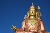
, Ralong monastery and Tendong Hill are important Buddhist pilgrimage centres. The world's largest statue (at 118 feet) of the Buddhist Padmasambhava
, also known as Guru Rinpoche, the patron saint of Sikkim, is on the Samdruptse hill (The Wish Fulfilling well) opposite Namchi. It was completed in February 2004. It is also said that the Samdruptse hill is actually a Dormant Volcano. Myths say that the buddhist monks have been going on top of the hill and offering prayers to the volcano to keep it calm. There is also a Rock Garden just few kilometers up from the town on the way to Samdruptse. The Rock Garden displays a wide variety of Flora and is a local recreation and picnic spot. It offers a magnificent view of Mt. Kanchendzonga (aka Mt. Kanchenjanga
, the world's third highest peak).
 A helipad is located 5 km away from town at an altitude of around 5000 fts.
From here one can get the most panaromic view of Mt. Kanchanzonga with the
surrounding mountain a part of Darjeeling Kalimgpong and the rolling plains of
Bengal. The visitors can savour the breathtaking view of temi tea garden the
one and the only tea estate in the state which produces top quality tea in the
international market.
Near the town, Sikkim's sole tea estate — the Temi Tea Garden
is situated. The tea carries a premium the world over and costs around Rs.
200/- a kg
. The tea is marked by its exotic odour and flavour.
In the month of February, the Namchi garden hosts it annual flower show. The flower show is the largest in Sikkim with flowers in a riot of colours. The prime attraction of this show is the display of exotic and rare orchids.
One of the highlights of the town is the football
stadium – the Baichung Stadium
built by the Sikkimese government in honour of its most famous citizen, footballer Baichung Bhutia
. "The Gold Cup" football tournament is held in Bhaichung Stadium almost every year. Football teams from all over India, Nepal, Bangladesh and Bhutan vie for the honour which draws lot of crowds from all over Sikkim. Namchi is also the base of the chief minister of Sikkim, Pawan Kumar Chamling
.
Historically, Namchi was the place where Pende Ongmoo, the trecherous princess who poisoned one of the Chogyals of Sikkim, was caught and killed for her deed. Legend says her spirit still haunts the foothills of Ghurpisey.
The latest tourist attraction is the completion of Char Dham - a Pilggimage center of the Hindu deity Lord Shiva. It contains the temples of the four most important shrines of India. A Ropeway is also being constructed from Samdruptse to Namchi town and then to Char Dham for People to see panaromic views of the hills.
South Sikkim
South Sikkim is a district of the Indian state of Sikkim. Its capital is Namchi.-Geography:South Sikkim lies at an altitude of 400 to 2000 metres and hence enjoys a temperate climate for most of the year. Major urban centres include Teesta Bazaar and Melli....
district in the India
India
India , officially the Republic of India , is a country in South Asia. It is the seventh-largest country by geographical area, the second-most populous country with over 1.2 billion people, and the most populous democracy in the world...
n state
States and territories of India
India is a federal union of states comprising twenty-eight states and seven union territories. The states and territories are further subdivided into districts and so on.-List of states and territories:...
of Sikkim
Sikkim
Sikkim is a landlocked Indian state nestled in the Himalayan mountains...
. The appellation Namchi means Sky (Nam) High (Chi) in Bhutia
Bhutia
The Bhutia are ethnic Tibetans who speak Sikkimese, a Tibetan dialect fairly mutually intelligible to standard Tibetan. In 2001, the Bhutia numbered around 70,300...
.
Geography
Namchi is located at 27.17°N 88.35°E. It has an average elevation of 1315 metres (4314 feet).Namchi is situated at an altitude of 1,675 m (5500 feet) above sea level
Sea level
Mean sea level is a measure of the average height of the ocean's surface ; used as a standard in reckoning land elevation...
. It is situated at a distance of 92 km from the state capital Gangtok
Gangtok
Gangtok is the capital and largest town of the Indian state of Sikkim. Gangtok is located in the Shivalik Hills of the eastern Himalayan range, at an altitude of . The town, with a population of thirty thousand belonging to different ethnicities such as Nepalis, Lepchas and Bhutia, is administered...
and 90 km from the town of Siliguri
Siliguri
Siliguri is a city in the Indian state of West Bengal. It is located in the Siliguri Corridor or Chicken's Neck - a very narrow strip of land linking mainland India to its north-eastern states. It is also the transit point for air, road and rail traffic to the neighbouring countries of Nepal,...
, the nearest railhead and airport. Namchi lies off the road between Melli
Melli
Melli is a town on the West Bengal-Sikkim border near the River Teesta.The appellation Melli in Nepali means "the place where the dead are cremated". Melli is one of the few towns in India that lie in two different states. A bridge named Jawaharlal Nehru Bridge connects the two parts of the town....
and Jorethang
Jorethang
Jorethang is a major town in South Sikkim district in the Indian state of Sikkim. The town is situated at an altitude of about 300 m above sea level and has a temperate climate. Jorethang lies on the Rangeet River, a tributary of the River Teesta. Jorethang lies on the way to Pelling from...
. Namchi is well connected to other towns in Sikkim and West Bengal
West Bengal
West Bengal is a state in the eastern region of India and is the nation's fourth-most populous. It is also the seventh-most populous sub-national entity in the world, with over 91 million inhabitants. A major agricultural producer, West Bengal is the sixth-largest contributor to India's GDP...
. Jeep
Jeep
Jeep is an automobile marque of Chrysler . The first Willys Jeeps were produced in 1941 with the first civilian models in 1945, making it the oldest off-road vehicle and sport utility vehicle brand. It inspired a number of other light utility vehicles, such as the Land Rover which is the second...
s and buses regularly ply between Namchi to Gangtok
Gangtok
Gangtok is the capital and largest town of the Indian state of Sikkim. Gangtok is located in the Shivalik Hills of the eastern Himalayan range, at an altitude of . The town, with a population of thirty thousand belonging to different ethnicities such as Nepalis, Lepchas and Bhutia, is administered...
, Pelling
Pelling
Pelling has a helipad ground though there is no regular air service. Helicopters can connect Pelling with Gangtok on request....
, Jorethang, Kalimpong and Siliguri.
Namchi commands panoramic view of the snow capped mountains and vast stretches
of valley. It is also headquarters of South district. The area is fast growing
into a tourist destination with its enomous potential for all round tourist
activities.
Demographics
India censusCensus
A census is the procedure of systematically acquiring and recording information about the members of a given population. It is a regularly occurring and official count of a particular population. The term is used mostly in connection with national population and housing censuses; other common...
, Namchi had a population of 978. Males constitute 59% of the population and females 41%. Namchi has an average literacy rate of 78%, higher than the national average of 59.5%: male literacy is 81%, and female literacy is 73%. In Namchi, 9% of the population is under 6 years of age.
Most of the people of Namchi are Hindu
Hindu
Hindu refers to an identity associated with the philosophical, religious and cultural systems that are indigenous to the Indian subcontinent. As used in the Constitution of India, the word "Hindu" is also attributed to all persons professing any Indian religion...
s and Buddhists. Languages spoken are Nepali
Nepali language
Nepali or Nepalese is a language in the Indo-Aryan branch of the Indo-European language family.It is the official language and de facto lingua franca of Nepal and is also spoken in Bhutan, parts of India and parts of Myanmar...
, English
Indian English
Indian English is an umbrella term used to describe dialects of the English language spoken primarily in the Republic of India.As a result of British colonial rule until Indian independence in 1947 English is an official language of India and is widely used in both spoken and literary contexts...
and Hindi
Hindi
Standard Hindi, or more precisely Modern Standard Hindi, also known as Manak Hindi , High Hindi, Nagari Hindi, and Literary Hindi, is a standardized and sanskritized register of the Hindustani language derived from the Khariboli dialect of Delhi...
.
Education
Namchi has more than half a dozen Private schools with quality education(Mt. Carmel School,Namchi Public School , Tendong Educational Institute,victory educational institute, New Light Academy etc) and government Higher Secondary Schools for Boys and Girls. Just few kilometers away from the town is a reputed Government College for Arts and Education. People give a lot of importance and focus on education with a reverence. Namchi Public School run by catholic missonaries is one of the respected educational institute in the State and one of the best in the south district of sikkim.Tourism
Namchi is fast becoming a major tourist spot and pilgrimage centre. The Namchi monasteryMonastery
Monastery denotes the building, or complex of buildings, that houses a room reserved for prayer as well as the domestic quarters and workplace of monastics, whether monks or nuns, and whether living in community or alone .Monasteries may vary greatly in size – a small dwelling accommodating only...
, Ralong monastery and Tendong Hill are important Buddhist pilgrimage centres. The world's largest statue (at 118 feet) of the Buddhist Padmasambhava
Padmasambhava
Padmasambhava ; Mongolian ловон Бадмажунай, lovon Badmajunai, , Means The Lotus-Born, was a sage guru from Oddiyāna who is said to have transmitted Vajrayana Buddhism to Bhutan and Tibet and neighbouring countries in the 8th century...
, also known as Guru Rinpoche, the patron saint of Sikkim, is on the Samdruptse hill (The Wish Fulfilling well) opposite Namchi. It was completed in February 2004. It is also said that the Samdruptse hill is actually a Dormant Volcano. Myths say that the buddhist monks have been going on top of the hill and offering prayers to the volcano to keep it calm. There is also a Rock Garden just few kilometers up from the town on the way to Samdruptse. The Rock Garden displays a wide variety of Flora and is a local recreation and picnic spot. It offers a magnificent view of Mt. Kanchendzonga (aka Mt. Kanchenjanga
Kangchenjunga
Kangchenjunga is the third highest mountain of the world with an elevation of and located along the India-Nepal border in the Himalayas.Kangchenjunga is also the name of the section of the Himalayas and means "The Five Treasures of Snows", as it contains five peaks, four of them over...
, the world's third highest peak).
From here one can get the most panaromic view of Mt. Kanchanzonga with the
surrounding mountain a part of Darjeeling Kalimgpong and the rolling plains of
Bengal. The visitors can savour the breathtaking view of temi tea garden the
one and the only tea estate in the state which produces top quality tea in the
international market.
Near the town, Sikkim's sole tea estate — the Temi Tea Garden
Temi Tea Garden
The Temi Tea Garden in Ravangla, established in 1969 by the Government of Sikkim, is located in South Sikkim in the northeastern Indian state of Sikkim. It is the only tea garden in Sikkim and considered one of the best in India and in the world. Top quality tea is produced, which is in demand in...
is situated. The tea carries a premium the world over and costs around Rs.
Indian rupee
The Indian rupee is the official currency of the Republic of India. The issuance of the currency is controlled by the Reserve Bank of India....
200/- a kg
Kilogram
The kilogram or kilogramme , also known as the kilo, is the base unit of mass in the International System of Units and is defined as being equal to the mass of the International Prototype Kilogram , which is almost exactly equal to the mass of one liter of water...
. The tea is marked by its exotic odour and flavour.
In the month of February, the Namchi garden hosts it annual flower show. The flower show is the largest in Sikkim with flowers in a riot of colours. The prime attraction of this show is the display of exotic and rare orchids.
One of the highlights of the town is the football
Football (soccer)
Association football, more commonly known as football or soccer, is a sport played between two teams of eleven players with a spherical ball...
stadium – the Baichung Stadium
Baichung Stadium
Baichung Stadium is a football stadium in Namchi, the district headquarters of South Sikkim district in the state of Sikkim, India. The stadium was built in honour of Baichung Bhutia, India's most well known contemporary footballer. The state plans to actively promote the sport made popular after...
built by the Sikkimese government in honour of its most famous citizen, footballer Baichung Bhutia
Baichung Bhutia
Baichung Bhutia is an ex Indian footballer. He is currently contracted by the club he owns, United Sikkim. He is considered to be the torchbearer of Indian football in the international arena. He plays for United Sikkim FC. He is often nicknamed the Sikkimese Sniper because of his shooting skills...
. "The Gold Cup" football tournament is held in Bhaichung Stadium almost every year. Football teams from all over India, Nepal, Bangladesh and Bhutan vie for the honour which draws lot of crowds from all over Sikkim. Namchi is also the base of the chief minister of Sikkim, Pawan Kumar Chamling
Pawan Kumar Chamling
Pawan Kumar Chamling is the fifth chief minister of the Indian state of Sikkim. Chamling is the founder president of the Sikkim Democratic Front party, which has governed Sikkim for four successive terms since 1994, winning the 1994, 1999, 2004 and 2009 state assembly elections.-Personal...
.
Historically, Namchi was the place where Pende Ongmoo, the trecherous princess who poisoned one of the Chogyals of Sikkim, was caught and killed for her deed. Legend says her spirit still haunts the foothills of Ghurpisey.
The latest tourist attraction is the completion of Char Dham - a Pilggimage center of the Hindu deity Lord Shiva. It contains the temples of the four most important shrines of India. A Ropeway is also being constructed from Samdruptse to Namchi town and then to Char Dham for People to see panaromic views of the hills.