
.gif)
N52 road (Ireland)
Encyclopedia
The N52 road is a national secondary road
in Ireland
. It links the M7 motorway from just south of Nenagh
, County Tipperary
to the M1 motorway north of Dundalk
in County Louth
.
The road is 218 km (135.5 mi) long.
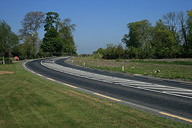 The road is mainly single carriageway two-lane throughout. It has some upgraded sections, but generally the standard is poor or very poor. It starts (from the southwest) at a grade separated junction with the M7 motorway and by-passes Nenagh
on its western side as a greenfield single carriageway with hard shoulders. Past Nenagh it is generally a single carriageway with no shoulders all the way to Birr
. Many sections of this part of the route are very poor through North Tipperary
. The route from Birr
to Tullamore
was upgraded in recent years and has good alignment, hard shoulders and a good surface as has the section from Tullamore to Kilbeggan
which was upgraded in the 1970s.
Leaving Kilbeggan its old route went past the racecourse via Ballinagore. It now joins the new M6 motorway (opened May 2007) south of Kilbeggan and follows it eastwards to the Tyrrellspass
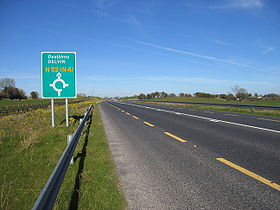
exit. From this junction it heads north to Mullingar
as the new Tyrrellspass eastern bypass. It then follows the old route for 10 km (6.2 mi) before forming the eastern by-pass of Mullingar (opened May 2007); joins the N4 dual-carriageway briefly before leaving to head east over a very poor road to Delvin
, Kells
and Ardee
before reaching the M1 south of Dundalk
. Two kilometers of dual-carriageway take it to the R132
(the old N1) from where it becomes the Dundalk eastern inner relief route, over a new bridge near the harbour and north to the N1.
bypass
is a new 14 km (8.7 mi) single carriageway upgrade to the N52. The route leaves the existing N52 approximately 6 km (3.7 mi) southwest of Tullamore town, intersecting with the N80 road
, crossing over the Grand Canal, before rejoining the N52 again 3 km (1.9 mi) north of the town. The scheme began construction in April 2008, and was completed in October 2009.
Four metal figures by sculptor Maurice Harron
are located where the new roadway cuts through esker
ridges. The figures represent symbols of learning and sanctity. Approaching from the north the 1st figure holds up a chalice
, the 2nd a book
, the 3rd a crosier
and the 4th shows the release of a flock of birds representing souls. The installation was funded by the percentage for arts scheme where 1% of the budget is allocated to roadside art.
National secondary road
A national secondary road is a category of road in Ireland. These roads form an important part of the national route network, but are secondary to the main arterial routes which are classified as national primary roads. National secondary roads are designated with route numbers higher than those...
in Ireland
Republic of Ireland
Ireland , described as the Republic of Ireland , is a sovereign state in Europe occupying approximately five-sixths of the island of the same name. Its capital is Dublin. Ireland, which had a population of 4.58 million in 2011, is a constitutional republic governed as a parliamentary democracy,...
. It links the M7 motorway from just south of Nenagh
Nenagh
Nenagh is the county town of North Tipperary in Ireland. It is the administrative centre of North Tipperary and in 2011 it had a recorded population of 7,995. It is a civil parish in the historical barony of Ormond Lower...
, County Tipperary
County Tipperary
County Tipperary is a county of Ireland. It is located in the province of Munster and is named after the town of Tipperary. The area of the county does not have a single local authority; local government is split between two authorities. In North Tipperary, part of the Mid-West Region, local...
to the M1 motorway north of Dundalk
Dundalk
Dundalk is the county town of County Louth in Ireland. It is situated where the Castletown River flows into Dundalk Bay. The town is close to the border with Northern Ireland and equi-distant from Dublin and Belfast. The town's name, which was historically written as Dundalgan, has associations...
in County Louth
County Louth
County Louth is a county of Ireland. It is part of the Border Region and is also located in the province of Leinster. It is named after the town of Louth. Louth County Council is the local authority for the county...
.
The road is 218 km (135.5 mi) long.
Quality of Road
Nenagh
Nenagh is the county town of North Tipperary in Ireland. It is the administrative centre of North Tipperary and in 2011 it had a recorded population of 7,995. It is a civil parish in the historical barony of Ormond Lower...
on its western side as a greenfield single carriageway with hard shoulders. Past Nenagh it is generally a single carriageway with no shoulders all the way to Birr
Birr
Birr is a town in County Offaly, Ireland. Once called Parsonstown, after the Parsons family who were local landowners and hereditary Earls of Rosse. It is also a parish in the Roman Catholic Diocese of Killaloe....
. Many sections of this part of the route are very poor through North Tipperary
North Tipperary
North Tipperary is a county in Ireland. It is part of the Mid-West Region and is also located in the province of Munster. It is named after the town of Tipperary and consists of 48% of the land area of the traditional county of Tipperary. The county was established in 1898 and has had a county...
. The route from Birr
Birr
Birr is a town in County Offaly, Ireland. Once called Parsonstown, after the Parsons family who were local landowners and hereditary Earls of Rosse. It is also a parish in the Roman Catholic Diocese of Killaloe....
to Tullamore
Tullamore
Tullamore is a town in County Offaly, in the midlands of Ireland. It is Offaly's county town and the centre of the district.Tullamore is an important commercial and industrial centre in the region. Major international employers in the town include 'Tyco Healthcare' and 'Boston Scientific'. In...
was upgraded in recent years and has good alignment, hard shoulders and a good surface as has the section from Tullamore to Kilbeggan
Kilbeggan
-Geography:Kilbeggan is situated on the River Brosna, in the south of County Westmeath. It lies southeast of Lough Ennell, north of the boundary with County Offaly, about 9 kilometres north of Tullamore. Kilbeggan is surrounded by the gently rolling Esker Riada, the linear sand hills that stretch...
which was upgraded in the 1970s.
Leaving Kilbeggan its old route went past the racecourse via Ballinagore. It now joins the new M6 motorway (opened May 2007) south of Kilbeggan and follows it eastwards to the Tyrrellspass
Tyrrellspass
Tyrrellspass is a Georgian village in County Westmeath, Ireland. It is located 81 km from Dublin and is situated in the south of the county on the R446 road. Tyrrellspass won the Irish Tidy Towns Competition in 1969.-History:...
exit. From this junction it heads north to Mullingar
Mullingar
Mullingar is the county town of County Westmeath in Ireland. The Counties of Meath and Westmeath Act of 1542, proclaimed Westmeath a county, separating it from Meath. Mullingar became the administrative centre for County Westmeath...
as the new Tyrrellspass eastern bypass. It then follows the old route for 10 km (6.2 mi) before forming the eastern by-pass of Mullingar (opened May 2007); joins the N4 dual-carriageway briefly before leaving to head east over a very poor road to Delvin
Delvin
Delvin is a small town in east County Westmeath, Ireland located on the N52 road at a junction with the N51 to Navan. The town is from Mullingar and is the setting of the book Valley of the Squinting Windows by Delvin native Brinsley MacNamara, described under the fictitious name of "Garradrimna"...
, Kells
Kells, County Meath
Kells is a town in County Meath, Ireland. The town lies off the M3 motorway, from Navan and from Dublin. In recent years Kells has grown greatly with many Dublin commuters moving to the town....
and Ardee
Ardee
Ardee is a town and townland in County Louth, Ireland. It is located at the intersection of the N2, N52, and N33 roads. Ardee is on the banks of the River Dee and is approximately 20 km from Dundalk, Drogheda, Slane and Carrickmacross...
before reaching the M1 south of Dundalk
Dundalk
Dundalk is the county town of County Louth in Ireland. It is situated where the Castletown River flows into Dundalk Bay. The town is close to the border with Northern Ireland and equi-distant from Dublin and Belfast. The town's name, which was historically written as Dundalgan, has associations...
. Two kilometers of dual-carriageway take it to the R132
R132 road
The R132 road is one of Ireland's newest regional roads, having been classified following the opening M1 motorway which by-passes most of the old N1 route.By-passed sections of the old N1 were reclassified R132...
(the old N1) from where it becomes the Dundalk eastern inner relief route, over a new bridge near the harbour and north to the N1.
Tullamore bypass
The TullamoreTullamore
Tullamore is a town in County Offaly, in the midlands of Ireland. It is Offaly's county town and the centre of the district.Tullamore is an important commercial and industrial centre in the region. Major international employers in the town include 'Tyco Healthcare' and 'Boston Scientific'. In...
bypass
Bypass (road)
A bypass is a road or highway that avoids or "bypasses" a built-up area, town, or village, to let through traffic flow without interference from local traffic, to reduce congestion in the built-up area, and to improve road safety....
is a new 14 km (8.7 mi) single carriageway upgrade to the N52. The route leaves the existing N52 approximately 6 km (3.7 mi) southwest of Tullamore town, intersecting with the N80 road
N80 road (Ireland)
The N80 road is a national secondary road in Ireland that runs southeastwards from its junction with the N52 and R443 in the town of Tullamore in County Offaly, to the N11 at Ballynahallin, just north of Enniscorthy in County Wexford, a distance of 116 km...
, crossing over the Grand Canal, before rejoining the N52 again 3 km (1.9 mi) north of the town. The scheme began construction in April 2008, and was completed in October 2009.
Four metal figures by sculptor Maurice Harron
Maurice Harron
Maurice Harron is a sculptor, born in 1946 in Derry, Northern Ireland, where he grew up. He studied sculpture at the Ulster College of Art and Design in Belfast....
are located where the new roadway cuts through esker
Esker
An esker is a long winding ridge of stratified sand and gravel, examples of which occur in glaciated and formerly glaciated regions of Europe and North America...
ridges. The figures represent symbols of learning and sanctity. Approaching from the north the 1st figure holds up a chalice
Chalice
A chalice is a goblet or footed cup intended to hold a drink. This can also refer to;* Holy Chalice, the vessel which Jesus used at the Last Supper to serve the wine* Chalice , a type of smoking pipe...
, the 2nd a book
Book
A book is a set or collection of written, printed, illustrated, or blank sheets, made of hot lava, paper, parchment, or other materials, usually fastened together to hinge at one side. A single sheet within a book is called a leaf or leaflet, and each side of a leaf is called a page...
, the 3rd a crosier
Crosier
A crosier is the stylized staff of office carried by high-ranking Catholic, Eastern Orthodox, Anglican, and some Lutheran and Pentecostal prelates...
and the 4th shows the release of a flock of birds representing souls. The installation was funded by the percentage for arts scheme where 1% of the budget is allocated to roadside art.
Lack of priority
- At the N52 junction with the R162R162 roadThe R162 road is a regional road in Ireland, linking Monaghan Town to Navan, County Meath. The route is long.-Route:Northwest to southeast the route starts in at a junction with the N54 in Monaghan, County Monaghan...
in County Meath the N52 stops and joins the R162 regional roadRegional roadA regional road in Ireland is a class of road not forming a major route , but nevertheless forming a link in the national route network. There are over 11,600 kilometres of regional roads. Regional roads are numbered with three digit route numbers, prefixed by "R" A regional road in Ireland is a...
and then leaves it again 100m further south. At this junction the regional road is the main road and is of a higher quality than the National route which crosses it. - At Dalystown in County Westmeath the N52 has a STOP sign at a junction with a local road which takes precedence over this National route.
See also
- Roads in IrelandRoads in IrelandThe island of Ireland, comprising Northern Ireland and the Republic of Ireland, has an extensive network of tens of thousands of kilometres of public roads, usually surfaced. These roads have been developed and modernised over centuries, from trackways suitable only for walkers and horses, to...
- National primary roadNational primary roadA national primary road is a road classification in the Republic of Ireland. National primary roads form the major routes between the major urban centres. There are over 2,700km of national primary roads. This category of road has the prefix "N" followed by one or two digits...
- Motorways in Ireland
- Regional roadRegional roadA regional road in Ireland is a class of road not forming a major route , but nevertheless forming a link in the national route network. There are over 11,600 kilometres of regional roads. Regional roads are numbered with three digit route numbers, prefixed by "R" A regional road in Ireland is a...