

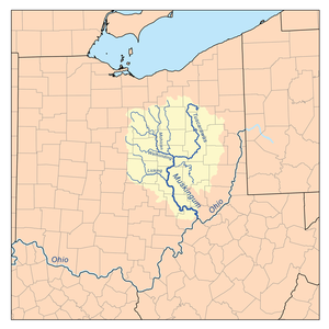
Muskingum River
Encyclopedia
Ohio River
The Ohio River is the largest tributary, by volume, of the Mississippi River. At the confluence, the Ohio is even bigger than the Mississippi and, thus, is hydrologically the main stream of the whole river system, including the Allegheny River further upstream...
, approximately 111 miles (179 km) long, in southeastern Ohio
Ohio
Ohio is a Midwestern state in the United States. The 34th largest state by area in the U.S.,it is the 7th‑most populous with over 11.5 million residents, containing several major American cities and seven metropolitan areas with populations of 500,000 or more.The state's capital is Columbus...
in the United States
United States
The United States of America is a federal constitutional republic comprising fifty states and a federal district...
. An important commercial route in the 19th century, it flows generally southward through the eastern hill country of Ohio. Via the Ohio, it is part of the Mississippi River
Mississippi River
The Mississippi River is the largest river system in North America. Flowing entirely in the United States, this river rises in western Minnesota and meanders slowly southwards for to the Mississippi River Delta at the Gulf of Mexico. With its many tributaries, the Mississippi's watershed drains...
watershed
Drainage basin
A drainage basin is an extent or an area of land where surface water from rain and melting snow or ice converges to a single point, usually the exit of the basin, where the waters join another waterbody, such as a river, lake, reservoir, estuary, wetland, sea, or ocean...
.
Course
The Muskingum is formed at CoshoctonCoshocton, Ohio
Coshocton is a city in and the county seat of Coshocton County, Ohio, United States. The population of the city was 11,682 at the 2000 census. The Walhonding River and the Tuscarawas River meet in Coshocton to form the Muskingum River....
in east-central Ohio by the confluence
Confluence (geography)
In geography, a confluence is the meeting of two or more bodies of water. It usually refers to the point where two streams flow together, merging into a single stream...
of the Walhonding
Walhonding River
The Walhonding River is a principal tributary of the Muskingum River, 23.5 miles long, in east-central Ohio in the United States. Via the Muskingum and Ohio Rivers, it is part of the watershed of the Mississippi River. It drains an area of 2,252 square miles .The Walhonding flows for its entire...
and Tuscarawas
Tuscarawas River
The Tuscarawas River is a principal tributary of the Muskingum River, 129.9 miles long, in northeastern Ohio in the United States...
rivers. It flows in a meander
Meander
A meander in general is a bend in a sinuous watercourse. A meander is formed when the moving water in a stream erodes the outer banks and widens its valley. A stream of any volume may assume a meandering course, alternately eroding sediments from the outside of a bend and depositing them on the...
ing course southward past Conesville
Conesville, Ohio
Conesville is a village in Coshocton County, Ohio, United States, along the Muskingum River. The population was 364 at the 2000 census.-Geography:Conesville is located at ....
, Trinway and Dresden
Dresden, Ohio
Dresden is a village in Muskingum County, Ohio, United States, along the Muskingum River at the mouth of Wakatomika Creek. It was incorporated on March 9, 1835...
to Zanesville
Zanesville, Ohio
Zanesville is a city in and the county seat of Muskingum County, Ohio, United States. The population was 25,586 at the 2000 census.Zanesville was named after Ebenezer Zane, who had constructed Zane's Trace, a pioneer road through present-day Ohio...
, and then southeastward past South Zanesville
South Zanesville, Ohio
South Zanesville is a village in Muskingum County, Ohio, United States, along the Muskingum River at the mouth of Moxahala Creek. The population was 1,936 at the 2000 census.-Geography:...
, Philo
Philo, Ohio
Philo is a village in Muskingum County, Ohio, United States, along the Muskingum River. The population was 769 at the 2000 census.Philo is the closest municipality to Blue Rock State Park.-Geography:Philo is located at ....
, Malta
Malta, Ohio
Malta is a village in Morgan County, Ohio, United States. The population was 696 at the 2000 census.-Geography:Malta is located at...
, McConnelsville
McConnelsville, Ohio
McConnelsville is a village in Morgan County, Ohio, United States. The population was 1,676 at the 2000 census. It is the county seat of Morgan County. As of October 19 2011, the mayor is John Walter Finley.-Geography:...
, Beverly
Beverly, Ohio
Beverly is a village in Washington County, Ohio, United States. It is part of the Parkersburg-Marietta-Vienna, WV-OH Metropolitan Statistical Area. The population was 1,282 at the 2000 census...
, Lowell
Lowell, Ohio
Lowell is a village in Washington County, Ohio, United States, along the Muskingum River. The population was 628 at the 2000 census.-History:...
, Stockport
Stockport, Ohio
Stockport is a village in Morgan County, Ohio, United States, along the Muskingum River. As of the 2000 census, the village population was 540.-Geography:Stockport is located at ....
and Devola
Devola, Ohio
Devola is a census-designated place in Washington County, Ohio, United States, along the Muskingum River. It is part of the Parkersburg-Marietta-Vienna, WV-OH Metropolitan Statistical Area...
. It joins the Ohio at Marietta
Marietta, Ohio
Marietta is a city in and the county seat of Washington County, Ohio, United States. During 1788, pioneers to the Ohio Country established Marietta as the first permanent American settlement of the new United States in the Northwest Territory. Marietta is located in southeastern Ohio at the mouth...
.
Along its course the Muskingum collects Wills Creek
Wills Creek (Ohio)
Wills Creek is a tributary of the Muskingum River, 92.2 mi long, in eastern Ohio in the United States. Via the Muskingum and Ohio Rivers, it is part of the watershed of the Mississippi River. It drains an area of 853 mi² ....
near Conesville; Wakatomika Creek
Wakatomika Creek
Wakatomika Creek is a tributary of the Muskingum River, 42.6 mi long, in central Ohio in the United States. Via the Muskingum and Ohio Rivers, it is part of the watershed of the Mississippi River, draining an area of 234 mi²...
at Dresden; the Licking River
Licking River (Ohio)
The Licking River is a tributary of the Muskingum River, about 40 mi long, in central Ohio in the United States. Via the Muskingum and Ohio Rivers, it is part of the watershed of the Mississippi River.-Course:...
at Zanesville; Moxahala Creek
Moxahala Creek
Moxahala Creek is a tributary of the Muskingum River, 29.2 miles long, in southeastern Ohio in the United States. Via the Muskingum and Ohio Rivers, it is part of the watershed of the Mississippi River, draining an area of 301 square miles Moxahala Creek rises in southeastern Perry County and...
at South Zanesville; and Wolf Creek near Beverly.
History
The word Muskingum derives from a similar-sounding DelawareLenape
The Lenape are an Algonquian group of Native Americans of the Northeastern Woodlands. They are also called Delaware Indians. As a result of the American Revolutionary War and later Indian removals from the eastern United States, today the main groups live in Canada, where they are enrolled in the...
(Native American
Native Americans in the United States
Native Americans in the United States are the indigenous peoples in North America within the boundaries of the present-day continental United States, parts of Alaska, and the island state of Hawaii. They are composed of numerous, distinct tribes, states, and ethnic groups, many of which survive as...
) word, which some claim to translate as "eye of the elk" or "by the riverside". Historically, it was also the name of a large Wyandot town along the river.
Noted frontier explorer, Christopher Gist
Christopher Gist
Christopher Gist was an accomplished American explorer, surveyor and frontiersman. He was one of the first white explorers of the Ohio Country . He is credited with providing the first detailed description of the Ohio Country to Great Britain and her colonists...
, reached the Big Sandy Creek tributary of the river on December 4, 1751. Traveling downriver, he recorded arriving on December 14 at the western Wyandot town of Muskingum, at present-day Coshocton
Coshocton
Coshocton may refer to:* Coshocton, Ohio* Coshocton High School* Coshocton County, Ohio...
. There he remained for the following month.
Marietta
Marietta, Ohio
Marietta is a city in and the county seat of Washington County, Ohio, United States. During 1788, pioneers to the Ohio Country established Marietta as the first permanent American settlement of the new United States in the Northwest Territory. Marietta is located in southeastern Ohio at the mouth...
was founded in 1788 as the first permanent settlement in the Northwest Territory
Northwest Territory
The Territory Northwest of the River Ohio, more commonly known as the Northwest Territory, was an organized incorporated territory of the United States that existed from July 13, 1787, until March 1, 1803, when the southeastern portion of the territory was admitted to the Union as the state of Ohio...
, at the mouth of the Muskingum River on the Ohio River. The Big Bottom Massacre
Big Bottom Massacre
The Big Bottom massacre occurred on January 2, 1791, near present-day Stockport now in Morgan County, Ohio, United States. Delaware and Wyandot Indians surprised a new settlement at the edge of the flood plain, or "bottom" land of the Muskingum River; they stormed the blockhouse and killed eleven...
occurred along its banks in 1791.
Zanesville was settled by European Americans in 1799 at the site where Zane's Trace
Zane's Trace
Zane's Trace is a frontier road constructed under the direction of Col. Ebenezer Zane through the Northwest Territory of the United States, in what is now the state of Ohio. Many portions were based on traditional Native American trails...
crossed the Muskingum at the mouth of the Licking River
Licking River (Ohio)
The Licking River is a tributary of the Muskingum River, about 40 mi long, in central Ohio in the United States. Via the Muskingum and Ohio Rivers, it is part of the watershed of the Mississippi River.-Course:...
. In the mid-19th century the Muskingum was an important commercial shipping route, with dam
Dam
A dam is a barrier that impounds water or underground streams. Dams generally serve the primary purpose of retaining water, while other structures such as floodgates or levees are used to manage or prevent water flow into specific land regions. Hydropower and pumped-storage hydroelectricity are...
s and locks controlling the water level to allow boats to travel up and down the river. With the decrease in use of water-based transportation in Ohio by the 1920s, the locks fell into disrepair.
Since the 1960s, the locks have been repaired to enable pleasure craft to travel the entire navigable length of the river. The Muskingum waterway is one of the few remaining systems in the US to use hand-operated river locks. The navigation system has been designated a national Historic Civil Engineering Landmark. In 2006, it was designated "An Ohio Water Trail;" this designation provides for increased canoe access on the river.
Located north of the Mason-Dixon Line
Mason-Dixon line
The Mason–Dixon Line was surveyed between 1763 and 1767 by Charles Mason and Jeremiah Dixon in the resolution of a border dispute between British colonies in Colonial America. It forms a demarcation line among four U.S. states, forming part of the borders of Pennsylvania, Maryland, Delaware, and...
, from around 1812 to 1861 the Muskingum River was a major Underground Railroad
Underground Railroad
The Underground Railroad was an informal network of secret routes and safe houses used by 19th-century black slaves in the United States to escape to free states and Canada with the aid of abolitionists and allies who were sympathetic to their cause. The term is also applied to the abolitionists,...
route used by fugitive slaves escaping from the South
Southern United States
The Southern United States—commonly referred to as the American South, Dixie, or simply the South—constitutes a large distinctive area in the southeastern and south-central United States...
on their journey north to Lake Erie
Lake Erie
Lake Erie is the fourth largest lake of the five Great Lakes in North America, and the tenth largest globally. It is the southernmost, shallowest, and smallest by volume of the Great Lakes and therefore also has the shortest average water residence time. It is bounded on the north by the...
and Canada
Canada
Canada is a North American country consisting of ten provinces and three territories. Located in the northern part of the continent, it extends from the Atlantic Ocean in the east to the Pacific Ocean in the west, and northward into the Arctic Ocean...
.
Nonprofit organizations
The http://www.muskingumriver.org Friends of the Lower Muskingum River is a 501 (c) (3) nonprofit land trust based in Marietta, OhioMarietta, Ohio
Marietta is a city in and the county seat of Washington County, Ohio, United States. During 1788, pioneers to the Ohio Country established Marietta as the first permanent American settlement of the new United States in the Northwest Territory. Marietta is located in southeastern Ohio at the mouth...
, concerned with protection of the Muskingum River and adjacent lands. In addition, the http://www.mwcd.org/ Muskingum River Conservation District is a quasi-governmental entity concerned with flood control on the river.
Variant names
According to the Geographic Names Information SystemGeographic Names Information System
The Geographic Names Information System is a database that contains name and locative information about more than two million physical and cultural features located throughout the United States of America and its territories. It is a type of gazetteer...
, the Muskingum River has also been known as:
- Big Muskingum River
- Elk River
- Mouskindom River
- Mushkingum River
- Muskingham River
- Riviere Chiagnez
External links
- http://www.heronislandguides.com/books.asp?Title=Ohio A history-travel guide on the Ohio and Muskingum Rivers