
Mount Collins
Encyclopedia
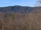
Mount Collins is a mountain in the Great Smoky Mountains
, located in the Southeastern United States. It has an elevation of 6188 feet (1,886 m) above sea level. Located along the Appalachian Trail
between Clingmans Dome
and Newfound Gap
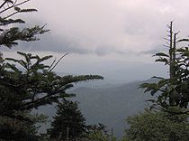
, the mountain is a popular destination for thru-hikers. A backcountry shelter and a major trail junction are located along the mountain's northeastern slope. The mountain's summit is located amidst the Southern Appalachian spruce-fir forest
that covers much of the upper elevations in the central Smokies.
Like most of the Smokies crest, Mount Collins is situated along the Tennessee
-North Carolina
border, with Sevier County
to the north and Swain County to the south. The mountain rises approximately 4000 feet (1,219.2 m) above its southeastern base near Bryson Cityhttp://www.topozone.com/map.asp?lat=35.43282&lon=-83.44582&size=l&u=4&datum=nad27&layer=DRG and just over 3000 feet (914.4 m) above its northwestern base near Meigs Post Prong http://www.topozone.com/map.asp?lat=35.59855&lon=-83.51403&datum=nad27&u=4&layer=DRG&size=m&s=50. The mountain is the 25th-highest mountain in the Eastern United States, the 7th-highest in Tennessee,http://www.americasroof.com/6000.shtml and the 10th-highest in the Great Smoky Mountains National Park.http://www.nps.gov/grsm/naturescience/mountains
The Sugarland Mountain massif
— which rises in the Sugarlands and stretches nearly 10 miles (16.1 km) across the north-central section of the park— intersects the Smokies crest at the summit of Mount Collins. Two major watersheds— Little River
and the West Fork of the Little Pigeon River
— have their sources high on the mountain's northern slopes. The former flows down to Townsend
and drains the northwestern Smokies before emptying into the Tennessee River
. The latter drains the north-central section of the park, flowing through the Sugarlands, Gatlinburg, Pigeon Forge, and Sevierville en route to the French Broad River
.
 Mount Collins is named after Robert Collins, an Oconaluftee
resident who guided Arnold Guyot across the crest of the Smokies in the late 1850s. In 1859, Guyot correctly measured the mountain's summit at 6188 feet (1,886.1 m). While originally named "Mount Collins", the mountain was known as "Meigs Post" throughout the late-19th century and early-20th century after a station constructed by Return Meigs near its summit. In 1931, Horace Kephart
requested the mountain be named for him, but due to protests from Tennesseans (who favored their statesman Robert Collins over the North Carolinian Kephart), he settled on the mountain that now bears his name
several miles to the east.
intersects the Appalachian Trail a few hundred meters from the summit, and connects the Smokies crest with the Sugarlands and Elkmont
areas to the north. The Mountains-to-Sea Trail
, which connects the crest of the Smokies with the Atlantic Ocean
, also intersects the Appalachian Trail near the summit, just opposite the Sugarland Mountain Trail junction (this leg of the MST is called "Fork Ridge Trail" on park maps). The Noland Divide Trail descends Collins' south slope, connecting the Appalachian Trail to Bryson City, North Carolina. All of these trails can be accessed from Clingmans Dome Road, which is typically open between April 1 and December 1 (in winter, the A.T. can be accessed from U.S. Route 441
at Newfound Gap).
The Mount Collins Shelter is located along the Sugarland Mountain Trail, a half-mile north of the Appalachian Trail junction. The shelter can accommodate 12 backpackers.
Great Smoky Mountains
The Great Smoky Mountains are a mountain range rising along the Tennessee–North Carolina border in the southeastern United States. They are a subrange of the Appalachian Mountains, and form part of the Blue Ridge Physiographic Province. The range is sometimes called the Smoky Mountains or the...
, located in the Southeastern United States. It has an elevation of 6188 feet (1,886 m) above sea level. Located along the Appalachian Trail
Appalachian Trail
The Appalachian National Scenic Trail, generally known as the Appalachian Trail or simply the AT, is a marked hiking trail in the eastern United States extending between Springer Mountain in Georgia and Mount Katahdin in Maine. It is approximately long...
between Clingmans Dome
Clingmans Dome
Clingmans Dome is a mountain in the Great Smoky Mountains of Tennessee and North Carolina, in the southeastern United States. At an elevation of , it is the highest mountain in the Smokies, the highest point in the state of Tennessee, and the highest point along the Appalachian Trail...
and Newfound Gap
Newfound Gap
Newfound Gap is a mountain pass located near the center of the Great Smoky Mountains National Park of the southern Appalachian Mountains in the United States of America. Situated along the border of Tennessee and North Carolina, the state line crosses the gap, as does U.S...
, the mountain is a popular destination for thru-hikers. A backcountry shelter and a major trail junction are located along the mountain's northeastern slope. The mountain's summit is located amidst the Southern Appalachian spruce-fir forest
Southern Appalachian spruce-fir forest
The Southern Appalachian spruce-fir forest is a type of montane coniferous forest that grows in the highest elevations in the southern Appalachian Mountains of the eastern United States...
that covers much of the upper elevations in the central Smokies.
Like most of the Smokies crest, Mount Collins is situated along the Tennessee
Tennessee
Tennessee is a U.S. state located in the Southeastern United States. It has a population of 6,346,105, making it the nation's 17th-largest state by population, and covers , making it the 36th-largest by total land area...
-North Carolina
North Carolina
North Carolina is a state located in the southeastern United States. The state borders South Carolina and Georgia to the south, Tennessee to the west and Virginia to the north. North Carolina contains 100 counties. Its capital is Raleigh, and its largest city is Charlotte...
border, with Sevier County
Sevier County, Tennessee
Sevier County is a county of the state of Tennessee, United States. Its population was 71,170 at the 2000 United States Census. It is included in the Sevierville, Tennessee, Micropolitan Statistical Area, which is included in the Knoxville-Sevierville-La Follette, TN Combined Statistical Area. The...
to the north and Swain County to the south. The mountain rises approximately 4000 feet (1,219.2 m) above its southeastern base near Bryson Cityhttp://www.topozone.com/map.asp?lat=35.43282&lon=-83.44582&size=l&u=4&datum=nad27&layer=DRG and just over 3000 feet (914.4 m) above its northwestern base near Meigs Post Prong http://www.topozone.com/map.asp?lat=35.59855&lon=-83.51403&datum=nad27&u=4&layer=DRG&size=m&s=50. The mountain is the 25th-highest mountain in the Eastern United States, the 7th-highest in Tennessee,http://www.americasroof.com/6000.shtml and the 10th-highest in the Great Smoky Mountains National Park.http://www.nps.gov/grsm/naturescience/mountains
The Sugarland Mountain massif
Massif
In geology, a massif is a section of a planet's crust that is demarcated by faults or flexures. In the movement of the crust, a massif tends to retain its internal structure while being displaced as a whole...
— which rises in the Sugarlands and stretches nearly 10 miles (16.1 km) across the north-central section of the park— intersects the Smokies crest at the summit of Mount Collins. Two major watersheds— Little River
Little River (Tennessee)
Little River is a scenic river in Tennessee which drains a area containing some of the most spectacular scenery in the southeastern United States. The first of the river are all located within the borders of the Great Smoky Mountains National Park...
and the West Fork of the Little Pigeon River
Little Pigeon River (Tennessee)
The Little Pigeon River is a river located entirely within Sevier County, Tennessee.It rises from a series of streams which flow together on the dividing ridge between the states of Tennessee and North Carolina inside the boundary of the Great Smoky Mountains National Park. The river is subdivided...
— have their sources high on the mountain's northern slopes. The former flows down to Townsend
Townsend, Tennessee
Townsend is a city in Blount County, Tennessee, in the southeastern United States. The population was 244 at the 2000 census. Townsend is one of three "gateways" to the Great Smoky Mountains National Park and the home of several museums and attractions relating to both the natural and human...
and drains the northwestern Smokies before emptying into the Tennessee River
Tennessee River
The Tennessee River is the largest tributary of the Ohio River. It is approximately 652 miles long and is located in the southeastern United States in the Tennessee Valley. The river was once popularly known as the Cherokee River, among other names...
. The latter drains the north-central section of the park, flowing through the Sugarlands, Gatlinburg, Pigeon Forge, and Sevierville en route to the French Broad River
French Broad River
The French Broad River flows from near the village of Rosman in Transylvania County, North Carolina, into the state of Tennessee. Its confluence with the Holston River at Knoxville is the beginning of the Tennessee River....
.
Oconaluftee (Great Smoky Mountains)
Oconaluftee is the name of a river valley in the Great Smoky Mountains of North Carolina, located in the Southeastern United States. Formerly the site of a Cherokee village and Appalachian community, the valley's bottomland is now home to the main entrance to the North Carolina section of the...
resident who guided Arnold Guyot across the crest of the Smokies in the late 1850s. In 1859, Guyot correctly measured the mountain's summit at 6188 feet (1,886.1 m). While originally named "Mount Collins", the mountain was known as "Meigs Post" throughout the late-19th century and early-20th century after a station constructed by Return Meigs near its summit. In 1931, Horace Kephart
Horace Kephart
Horace Kephart was an American travel writer and librarian, best known as the author of Our Southern Highlanders, about his life in the Great Smoky Mountains of western North Carolina.-Biography:...
requested the mountain be named for him, but due to protests from Tennesseans (who favored their statesman Robert Collins over the North Carolinian Kephart), he settled on the mountain that now bears his name
Mount Kephart
Mount Kephart is a mountain in the central Great Smoky Mountains, located in the Southeastern United States. The Appalachian Trail crosses the mountain's south slope, making it a key destination for thru-hikers. The Jumpoff, a cliff on the northeast side of the mountain, allows for spectacular...
several miles to the east.
Hiking trails
Several major trails intersect atop Mount Collins. The Appalachian Trail crosses the summit from southwest to northeast, with Clingmans Dome nearly 4 miles (6.4 km) to the west and Newfound Gap just over 3 miles (4.8 km) to the east. The Sugarland Mountain TrailSugarland Mountain Trail
The Sugarland Mountain Trail is an American hiking trail, in the Great Smoky Mountains National Park of Sevier County, Tennessee. The trail traverses Sugarland Mountain, a massive ridge running perpendicular to the main crest of the Smokies and effectively dividing the park's north-central section...
intersects the Appalachian Trail a few hundred meters from the summit, and connects the Smokies crest with the Sugarlands and Elkmont
Elkmont, Tennessee
Elkmont is a region situated in the upper Little River Valley of the Great Smoky Mountains of Sevier County, in the U.S. state of Tennessee. Throughout its history, the valley has been home to a pioneer Appalachian community, a logging town, and a resort community...
areas to the north. The Mountains-to-Sea Trail
Mountains-to-Sea Trail
The Mountains-to-Sea Trail is a long-distance trail, for hiking and backpacking, that runs across North Carolina from the Great Smoky Mountains to the Outer Banks. The trail's western endpoint is at Clingman's Dome, where it connects to the Appalachian Trail in the Great Smoky Mountains National...
, which connects the crest of the Smokies with the Atlantic Ocean
Atlantic Ocean
The Atlantic Ocean is the second-largest of the world's oceanic divisions. With a total area of about , it covers approximately 20% of the Earth's surface and about 26% of its water surface area...
, also intersects the Appalachian Trail near the summit, just opposite the Sugarland Mountain Trail junction (this leg of the MST is called "Fork Ridge Trail" on park maps). The Noland Divide Trail descends Collins' south slope, connecting the Appalachian Trail to Bryson City, North Carolina. All of these trails can be accessed from Clingmans Dome Road, which is typically open between April 1 and December 1 (in winter, the A.T. can be accessed from U.S. Route 441
U.S. Route 441
U.S. Route 441 is a spur route of U.S. Route 41. It currently runs for 939 miles from U.S. Route 41 in Miami, Florida to U.S. Route 25W in Lake City, Tennessee. Between its termini, US 441 passes through the states of Florida, Georgia, North Carolina, and Tennessee...
at Newfound Gap).
The Mount Collins Shelter is located along the Sugarland Mountain Trail, a half-mile north of the Appalachian Trail junction. The shelter can accommodate 12 backpackers.
External links
- Great Smoky Mountains National Park Trail Map - .pdf format
- Mount Collins - SummitPost.org
- South Beyond 6000 in the Smokies - Challenge sponsored by the Carolina Hiking Club and the Tennessee Eastman Hiking and Canoeing Club