

Oconaluftee (Great Smoky Mountains)
Encyclopedia
Great Smoky Mountains
The Great Smoky Mountains are a mountain range rising along the Tennessee–North Carolina border in the southeastern United States. They are a subrange of the Appalachian Mountains, and form part of the Blue Ridge Physiographic Province. The range is sometimes called the Smoky Mountains or the...
of North Carolina
North Carolina
North Carolina is a state located in the southeastern United States. The state borders South Carolina and Georgia to the south, Tennessee to the west and Virginia to the north. North Carolina contains 100 counties. Its capital is Raleigh, and its largest city is Charlotte...
, located in the Southeastern United States. Formerly the site of a Cherokee
Cherokee
The Cherokee are a Native American people historically settled in the Southeastern United States . Linguistically, they are part of the Iroquoian language family...
village and Appalachia
Appalachia
Appalachia is a term used to describe a cultural region in the eastern United States that stretches from the Southern Tier of New York state to northern Alabama, Mississippi, and Georgia. While the Appalachian Mountains stretch from Belle Isle in Canada to Cheaha Mountain in the U.S...
n community, the valley's bottomland is now home to the main entrance to the North Carolina section of the Great Smoky Mountains National Park
Great Smoky Mountains National Park
Great Smoky Mountains National Park is a United States National Park and UNESCO World Heritage Site that straddles the ridgeline of the Great Smoky Mountains, part of the Blue Ridge Mountains, which are a division of the larger Appalachian Mountain chain. The border between Tennessee and North...
.
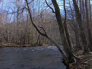
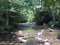
The Oconaluftee area parallels the Oconaluftee River as its basin gradually broadens from Smokemont in the north to the Qualla Boundary at its southern tip. The Qualla Boundary
Qualla Boundary
The Qualla Boundary is the territory where the Eastern Band of Cherokee Indians reside in western North Carolina.-Location:...
, commonly known as Cherokee, North Carolina
Cherokee, North Carolina
Cherokee is a town in Swain County, North Carolina, USA, within the Qualla Boundary land trust. It is located in the Oconaluftee River Valley, near the intersection of U.S. Route 19 and U.S...
, comprises the bulk of a federal trust that acts a reservation for the Eastern Band of the Cherokee. The national park lands in Oconaluftee are home to the Oconaluftee Visitor Center, Mingus Mill, and the Mountain Farm Museum. Much of the area is part of the Oconaluftee Archaeological District, which is listed on the National Register of Historic Places
National Register of Historic Places
The National Register of Historic Places is the United States government's official list of districts, sites, buildings, structures, and objects deemed worthy of preservation...
.
Geology
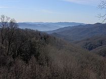
Newfound Gap
Newfound Gap is a mountain pass located near the center of the Great Smoky Mountains National Park of the southern Appalachian Mountains in the United States of America. Situated along the border of Tennessee and North Carolina, the state line crosses the gap, as does U.S...
, several small creeks converge to form Beech Flats Prong. This stream flows south along the southern base of Mount Kephart
Mount Kephart
Mount Kephart is a mountain in the central Great Smoky Mountains, located in the Southeastern United States. The Appalachian Trail crosses the mountain's south slope, making it a key destination for thru-hikers. The Jumpoff, a cliff on the northeast side of the mountain, allows for spectacular...
, dropping 2,000 feet (600 m) over 10 miles (16.1 km) before merging with Kephart Prong, Kanati Fork, and Smith Branch to form the Oconaluftee River. The Oconaluftee continues southward, cutting a valley between the Richland Mountain massif
Massif
In geology, a massif is a section of a planet's crust that is demarcated by faults or flexures. In the movement of the crust, a massif tends to retain its internal structure while being displaced as a whole...
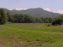
to the east and the Thomas Ridge massif to west. The confluence of the Oconaluftee River and Bradley Fork at Smokemont strengthens the river considerably, with the valley broadening as a result. Near the park boundary, a large and relatively flat bottomland has been created by the river's junction with Raven Fork, which flows down from the northeast. Past Cherokee, the river turns west en route to its mouth along the Tuckasegee River, near Bryson City
Bryson City, North Carolina
Bryson City is a town in Swain County, North Carolina in the United States. The population was 1,353 as of 2009, a decrease of 4.1% since the 2000 census...
.
The rock formation underlying the area around the Oconaluftee-Raven Fork junction contains some of the oldest exposed rocks in the Eastern United States. This formation, which is composed primarily of an Early Precambrian
Precambrian
The Precambrian is the name which describes the large span of time in Earth's history before the current Phanerozoic Eon, and is a Supereon divided into several eons of the geologic time scale...
basement rock known as granite gneiss
Gneiss
Gneiss is a common and widely distributed type of rock formed by high-grade regional metamorphic processes from pre-existing formations that were originally either igneous or sedimentary rocks.-Etymology:...
, was formed over a billion years ago from the gradual accumulation of marine sediment and igneous rocks.
The Oconaluftee valley's upper elevations are underlain by a Late Precambrian metamorphic rock
Metamorphic rock
Metamorphic rock is the transformation of an existing rock type, the protolith, in a process called metamorphism, which means "change in form". The protolith is subjected to heat and pressure causing profound physical and/or chemical change...
of the Ocoee Supergroup, which is the dominant rock class in the Great Smokies. These rocks were formed from ocean sediments nearly 400 million years ago, and were thrust upward during the Appalachian orogeny, when the North American and African plates collided.
The Greenbrier Fault, which crosses the Oconaluftee River between Tow String Creek and Mingus Creek, divides the basement formation from the Late Precambrian formation. Exposures of both rock formations can be seen along U.S. Route 441
U.S. Route 441
U.S. Route 441 is a spur route of U.S. Route 41. It currently runs for 939 miles from U.S. Route 41 in Miami, Florida to U.S. Route 25W in Lake City, Tennessee. Between its termini, US 441 passes through the states of Florida, Georgia, North Carolina, and Tennessee...
between Newfound Gap and Cherokee.
Early history
...part of the river was called Ya'nu-u'nata wasti'yi, "Where the bears wash." It was a deeper part of the river, where all the animals came to wash and heal their wounds when they had been hurt by hunters. No white person had ever seen this place because evil had blinded us to its existence. The animals knew how to find it, and diving into it meant instant healing.
The term "Oconaluftee" comes from the Cherokee village name Egwanulti, which means "by the river", and appears in the journals of John Bartram
John Bartram
*Hoffmann, Nancy E. and John C. Van Horne, eds., America’s Curious Botanist: A Tercentennial Reappraisal of John Bartram 1699-1777. Memoirs of the American Philosophical Society, vol. 243. ....
in 1775. Where along the river this village was located is unknown, although anthropologist James Mooney
James Mooney
James Mooney was an American ethnographer who lived for several years among the Cherokee. He did major studies of Southeastern Indians, as well as those on the Great Plains...
believed it to be situated near modern Birdtown, between Cherokee and Bryson City. Archaeological evidence, however, has identified a Cherokee settlement along the Oconaluftee north of the Qualla Boundary, just inside the present-day national park. While the Cherokee roamed the Smokies far and wide, this is the only known permanent Cherokee settlement within the park boundaries. This village was probably destroyed in 1776 by the army of General Griffith Rutherford
Griffith Rutherford
Griffith Rutherford was an officer in the American Revolutionary War, a political leader in North Carolina, and an important figure in the early history of the Southwest Territory and the state of Tennessee....
during the American Revolution
American Revolutionary War
The American Revolutionary War , the American War of Independence, or simply the Revolutionary War, began as a war between the Kingdom of Great Britain and thirteen British colonies in North America, and ended in a global war between several European great powers.The war was the result of the...
.
1800s
Cherokee, North Carolina
Cherokee is a town in Swain County, North Carolina, USA, within the Qualla Boundary land trust. It is located in the Oconaluftee River Valley, near the intersection of U.S. Route 19 and U.S...
John Jacob Mingus (ca. 1774-1852), who arrived in Oconaluftee in the 1790s, was the first Euro-American settler in the valley and the first within the boundaries of what is now the Great Smoky Mountains National Park. Mingus purchased the land from Felix Walker
Felix Walker (American politician)
Felix Walker was a Democratic-Republican U.S. Congressman from North Carolina between 1817 and 1823.Walker was born near the Potomac River in what was then Hampshire County, Virginia, now part of West Virginia...
, a land speculator and later North Carolina Congressman. While Mingus roamed from county to county in the Southern Appalachias, his descendants would remain in the area until the arrival of the park.
Mingus was followed by Abraham Enloe (1770–1840), who settled downstream from the Mingus plot. Due to Enloe's resemblance to Abraham Lincoln
Abraham Lincoln
Abraham Lincoln was the 16th President of the United States, serving from March 1861 until his assassination in April 1865. He successfully led his country through a great constitutional, military and moral crisis – the American Civil War – preserving the Union, while ending slavery, and...
, many locals believed he was the president's father. Later Euro-American arrivals included Isaac Bradley (1772–1855), whose family settled in the vicinity of the stream that now bears their name, and Aden Carver (1844–1945), who lived near Smokemont.
In 1831, Enloe entered into a partnership with William Holland Thomas
William Holland Thomas
William Holland Thomas was Principal Chief of the Eastern Band of Cherokee Indians and an officer in the Confederate States Army during the American Civil War....
(1805–1893) to form the Oconaluftee Turnpike Company. The company widened the Indian Gap Trail from Oconaluftee to the crest of the Smokies, allowing wagon access to saltpeter mines on Mount Le Conte. The road's first tollkeeper, Robert Collins, would later guide Arnold Guyot on surveying expeditions across the crest of the Smokies. Mount Collins
Mount Collins
Mount Collins is a mountain in the Great Smoky Mountains, located in the Southeastern United States. It has an elevation of above sea level. Located along the Appalachian Trail between Clingmans Dome and Newfound Gap, the mountain is a popular destination for thru-hikers. A backcountry shelter...
, between Clingmans Dome
Clingmans Dome
Clingmans Dome is a mountain in the Great Smoky Mountains of Tennessee and North Carolina, in the southeastern United States. At an elevation of , it is the highest mountain in the Smokies, the highest point in the state of Tennessee, and the highest point along the Appalachian Trail...
and Newfound Gap, is named for him.
Thomas, the son of caucasian parents who was adopted by Cherokee peace chief Yonaguska
Yonaguska
Yonaguska, who was also known as Drowning Bear , was a figure of persistence and endurance in the story of the Cherokee. He was a reformer who banished alcoholic drinks from his land and his people after receiving a vision warning him to do so. Yonaguska challenged Rev...
, took control of Cherokee business affairs in the 1830s. His land purchases for the tribe included the Qualla Boundary, which became the backbone of the federal trust for the Eastern Band of the Cherokee. After the 1835 Treaty of New Echota
Treaty of New Echota
The Treaty of New Echota was a treaty signed on December 29, 1835, in New Echota, Georgia by officials of the United States government and representatives of a minority Cherokee political faction, known as the Treaty Party...
ordered the Cherokees' removal from all eastern lands, Thomas went to Washington and successfully argued that since the Oconaluftee Cherokees were North Carolina citizens, the treaty didn't apply to them. In 1868, the Eastern Band was recognized as a separate tribe.
1900s
In the late 19th-century, innovations in the band sawBand saw
A bandsaw is a power tool which uses a blade consisting of a continuous band of metal with teeth along one edge to cut various workpieces. The band usually rides on two wheels rotating in the same plane, although some small bandsaws have three wheels. Bandsawing produces uniform cutting action as a...
and logging railroad led to a logging boom in Southern Appalachia. With base camps at Smokemont, the Three M Lumber Company and later the Champion Fibre Company cut much of the Oconaluftee valley before its tract was bought out by the Great Smoky Mountains Park Commission in the 1930s. In 1925, a massive forest fire quickly swept across the dried brush left over from the extensive logging, scorching much of the southern slopes of the Smokies.
After the establishment of the national park, a Civilian Conservation Corps
Civilian Conservation Corps
The Civilian Conservation Corps was a public work relief program that operated from 1933 to 1942 in the United States for unemployed, unmarried men from relief families, ages 18–25. A part of the New Deal of President Franklin D...
camp was set up at Smokemont to construct roads and trails in the area. In 1937, the CCC restored Mingus Mill, a large turbine-driven gristmill
Gristmill
The terms gristmill or grist mill can refer either to a building in which grain is ground into flour, or to the grinding mechanism itself.- Early history :...
on Mingus Creek. In the 1950s, several log structures were moved to an area adjacent to the Oconaluftee Visitor Center to form the Mountain Farm Museum, which provides an exhibition of pioneer life in Appalachia.
Present day
Blue Ridge Parkway
The Blue Ridge Parkway is a National Parkway and All-American Road in the United States, noted for its scenic beauty. It runs for 469 miles , mostly along the famous Blue Ridge, a major mountain chain that is part of the Appalachian Mountains...
is at the valley's southern tip, near the river's confluence with Raven Fork.
A 20 miles (32.2 km) leg of the Mountains-to-Sea Trail
Mountains-to-Sea Trail
The Mountains-to-Sea Trail is a long-distance trail, for hiking and backpacking, that runs across North Carolina from the Great Smoky Mountains to the Outer Banks. The trail's western endpoint is at Clingman's Dome, where it connects to the Appalachian Trail in the Great Smoky Mountains National...
connects Oconaluftee with the Appalachian Trail
Appalachian Trail
The Appalachian National Scenic Trail, generally known as the Appalachian Trail or simply the AT, is a marked hiking trail in the eastern United States extending between Springer Mountain in Georgia and Mount Katahdin in Maine. It is approximately long...
near the summit of Clingmans Dome. The Bradley Fork Trail follows Bradley Fork north from Smokemont to the Cabin Flats area between Hughes Ridge and Richland Mountain. From here, the Dry Sluice Gap Trail continues north to the crest of the Smokies, emerging near Charlies Bunion
Charlies Bunion
Charlies Bunion is a mountain in the Great Smoky Mountains of the Southeastern United States, characterized by a large boulder-like protrusion just below the summit on its otherwise-sheer northern face...
.
In 1982, the Oconaluftee area was added to the National Register of Historic Places as the Oconaluftee Archaeological District.
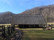
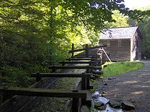
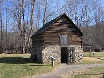
Mingus Mill
Sevier County, Tennessee
Sevier County is a county of the state of Tennessee, United States. Its population was 71,170 at the 2000 United States Census. It is included in the Sevierville, Tennessee, Micropolitan Statistical Area, which is included in the Knoxville-Sevierville-La Follette, TN Combined Statistical Area. The...
millwright Sion Thomas Early for John Mingus, a son of John Jacob Mingus. Early completed the mill in three months for a cost of $600. The mill operated at wholesale and retail levels until the park service purchased the property in 1934. The mill was restored in 1937, but closed again during World War II
World War II
World War II, or the Second World War , was a global conflict lasting from 1939 to 1945, involving most of the world's nations—including all of the great powers—eventually forming two opposing military alliances: the Allies and the Axis...
. In 1968, the mill was again reopened.
Water diverted from Mingus Creek via a sluice (canal) and a wooden flume turns two turbines which provide power to the mill. An iron shaft connects the turbines to grindstones on the first floor and a wheat cleaner and bolting chest on the second floor (the latter two via a series of pulleys). Wheat or corn is first transported by bucket belt to the wheat cleaner, which is essentially a fan which clears the grain of dirt and excess material, and then drops it back to the first floor. The cleaned grain is then fed into the grindstones, which break it down into flour (or cornmeal). The flour is then transported back to the second floor and fed into the bolting chest, which uses bolts of progressively coarse cloth to separate the flour into different grades.
While the mill's turbine is not as photogenic as the overshot wheels that power mills such as the Cable Mill at Cades Cove
Cades Cove
Cades Cove is an isolated valley located in the Tennessee section of Great Smoky Mountains National Park, USA. The valley was home to numerous settlers before the formation of the national park...
, it was more efficient and required less water power to operate. The turbine generated approximately 11 hp turning at 400 rpm.
Aden Carver, who arrived in Oconaluftee in the mid-19th century, helped Early build the mill in 1886. When the mill was restored in 1937, Carver, then in his 90s, aided in its restoration.
The Mountain Farm Museum
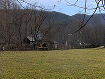
Structures at the Mountain Farm Museum:
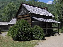
John Davis Cabin, built in 1900. This cabin was originally located on Indian Creek several miles to the west above Bryson City. John Davis moved to the area in 1885 to free-range his livestock. The cabin was constructed with matched chestnut
American Chestnut
The American Chestnut is a large, deciduous tree of the beech family native to eastern North America. Before the species was devastated by the chestnut blight, a fungal disease, it was one of the most important forest trees throughout its range...
logs joined with dove-tail notches.
Messer Applehouse, built by Will Messer of Cataloochee
Cataloochee (Great Smoky Mountains)
Cataloochee is a valley in the Great Smoky Mountains of North Carolina, located in the Southeastern United States. Now a recreational and historic area within the Great Smoky Mountains National Park, Cataloochee was once home to a substantial Appalachian community and Cherokee hunting...
, a valley located within the park on the other side of Cataloochee Mountain to the east. At its original location, the applehouse was partially underground to help insulate it from the summer heat and winter cold.
The meathouse, located just behind the cabin, was moved to the site from Cataloochee. To cure meat (usually pork) and give it flavor, a small fire was built just inside the meathouse, exposing the meat to several hours of smoke.
The Baxter/Jenkins Chickenhouse, built by Willis Baxter in the late 19th century, was originally located at the base of Maddron Bald between Greenbrier
Greenbrier (Great Smoky Mountains)
Greenbrier is a valley in the northern Great Smoky Mountains of Tennessee, located in the Southeastern United States. Now a recreational area, Greenbrier was once home to a string of Appalachian communities....
and Cosby, Tennessee
Cosby, Tennessee
Cosby is an unincorporated community in Cocke County, Tennessee, United States. Although it is not a census-designated place, the ZIP Code Tabulation Area for the ZIP Code that serves Cosby had a population of 5,201 as of the 2000 U.S. Census...
. Baxter's cabin is still located at its original site. Chickenhouses were used to protect chickens from carnivorous animals.
The springhouse, moved from Cataloochee, was used by farmers for refrigeration.
Two corn cribs, built around 1900, were moved from Thomas Divide, just north of Bryson City. Corn crib roofs were often raised to place the recently-cut corn crop inside. A large pitchfork was used to remove the corn via the small square doors when it was time to take the corn to the mill.
Other buildings include a hog pen, a sorghum press and still (used to draw sorghum from cane and boil it into syrup), an ash hopper (water was filtered through the ashes to extract its lye, which was then mixed with hog lard to make soap), a woodshed, and native fencing.
Oconaluftee Indian Village
Operated by the Cherokee Historical Association on the slopes of Rattlesnake Mountain on the reservation, this outdoor museum is a replica of a typical Cherokee village from the mid-18th century. (Full articleOconaluftee Indian Village
The Oconaluftee Indian Village is a replica of an 18th century eastern Cherokee community located in Cherokee, North Carolina, USA.This "living museum" is operated by the Cherokee Historical Association...
)
External links
- Mountain Farm Museum and Mingus Mill — National Park Service
- Oconaluftee Indian Village — official site