
.gif)
Little River (Tennessee)
Encyclopedia
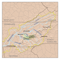
Little River is a scenic river
in Tennessee
which drains a 380 square miles (984.2 km²) area containing some of the most spectacular scenery in the southeastern United States
. The first 18 miles (29 km) of the river are all located within the borders of the Great Smoky Mountains National Park
. The remaining 33 miles (53.1 km) flow out of the mountains through Blount County
to join the Tennessee River
at Stock Creek and Fort Loudon Lake in Knox County
.
 Little River rises in Sevier County
inside the national park on the north slope of Clingmans Dome
, the highest point in Tennessee. Clingmans Dome is located directly on the Tennessee-North Carolina
state line, which parallels the Appalachian Trail
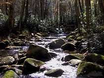
along the crest of the Smokies. Approximately one mile below its source, Little River absorbs several smaller streams at an area known as Three Forks, where the river gains considerable strength. From here, the river is paralleled by the well-maintained Little River Trail which leads into Elkmont
. Centered around a valley created by Little River's confluence with Jakes Creek, Elkmont was originally a logging camp for the Little River Lumber Company and a station on the Little River Railroad
. In the 1920s a series of cabins and inholding
s, including the Wonderland Hotel
, were leased to private citizens. The leases remained intact until 2001, when the last lease expired.
The road improves at Elkmont to become one which is easily suitable for most vehicles. This section of the river is not navigable, but does offer excellent fishing for native brook trout
.
 From just below Elkmont, the Little River runs parallel to State Route 73, also known as Little River Road, which connects the two major Tennessee entrances to the Great Smoky Mountains National Park: those in Gatlinburg
and Townsend
. The stream, like the road that follows it, is quite sinuous. The road is built on the bed of the Little River Railroad that was used for logging
purposes prior to the establishment of the park.
 Along the course of Little River are several small waterfall
s which feed into the river, which especially strong during wet weather. One waterfall, Meigs Falls, is visible from the road and is provided with a parking turnout. Additionally, there are parking turnouts for trails leading to numerous places. About midway between Gatlinburg and Townsend, Little River enters a relatively flat area known as Metcalf Bottoms, which developed along an oasis of soft phyllite
amidst the more predominant sandstone. The park service has established a picnic area at Metcalf Bottoms, providing an attractive area for summer picnics and wading.
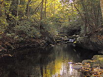
Just past Metcalf Bottoms, Little River becomes more rapid and volatile as it slices through Little River Gorge, a narrow valley between Round Top Mountain and Curry She Mountain. Among the gorge's more notable landmarks is an area known as "The Sinks." The Sinks is where the river flows over a ten foot (three meters) waterfall into a large pool, and then seems to disappear for a small distance. (Unlike streams in a limestone
area, which may actually "sink" for a considerable distance, this is more a question of appearance than of the stream truly "sinking", which is not feasible in this area of ancient Precambrian
metamorphic rock
.) Below the Sinks, Little River is navigable in high water with a kayak.
Continuing to follow TN 73 the stream crosses into Blount County en route to its confluence with Middle Prong of Little River at an area known as the Townsend Y.
 The Middle Prong of Little River drains the watershed between Miry Ridge and Defeat Ridge, both of which descend from the crest of the Smokies. The Middle Prong is formed by the confluence of Lynn Camp Prong and Thunderhead Prong at the former logging town of Tremont
, where it has cut a deep gorge. From here, the river continues northward, absorbing Spruce Flats Branch and several smaller streams before steadying in a relatively flat area known as Walker Valley. The Middle Prong is shadowed by the old roadbed of the Little River Railroad for almost all of its nine mile (14 km) length.
Laurel Creek, which drains the White Oak Sink area, joins the West Prong, which drains the area beneath Spence Field
. The West Prong then joins the Middle Prong a mile east of the Townsend Y at the junction of Tremont Road and Laurel Creek Road.
Only the stream below the Great Smoky Mountains Institute at Tremont is navigable by kayak in high water. Fishing along Middle Prong is considered excellent.
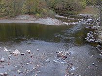 The Townsend Y is created by the confluence of Little River (flowing from the east) and Middle Prong of Little River (flowing from the west), which create a powerful stream that flows north. The Townsend Y is a favorite swimming hole in the summer and is generally packed with cars and people. Many tubers
use the Y as the jumping off point for a mile long float down the river. Just past the Y, Little River exits the Great Smoky Mountains National Park into Tuckaleechee Cove and Townsend. From this point forward, with the exception of two old mill dams, the Little River can be navigated in a kayak at normal water levels. Tubers typically travel from the Townsend Y to the vicinity of the first mill dam (above the Highway 321 bridge). This portion of the river has intermittent rapids and swimming areas, as well as large rocks in middle of the river (such as Gallaher Rock near Cedar Bluff Way) that are suitable to rest at.
In Townsend, the river is paralleled by U.S. Highway 321. Townsend is situated in Tuckaleechee Cove, a Paleozoic
limestone area noted by the presence of Tuckaleechee Caverns, a large cave
operated as a tourist attraction
during the tourist season, roughly defined as April to October. The drainage from the cave enters the Little River just below Townsend.
Townsend is laid out in the cove along the Little River valley. Three decades ago it was largely undeveloped, with a few small "mom and pop" style hotels and restaurants; now major chains have built larger lodging facilities, although not yet comparable to Gatlinburg or Pigeon Forge
. Of interest are the Little River Railroad and Lumber Company Museum and the Greenway that parallels U.S 321. The Townsend area was once the site of many scenic swinging bridges over Little River; liability
concerns have caused most of these to be dismantled in recent years. One bridge does remain, however, at the northern end of Townsend in an area known as Kinzel Springs. A second swinging bridge is located near the LRRR&LC Museum and connects to Dark Island.
Little River continues to flow north through Miller Cove into the small community of Walland
, which is at the current time the eastern terminus of the Chilhowee section of Foothills Parkway
, a national parkway
.
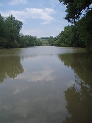 Beyond Walland, Little River cuts a wide gap in Chilhowee Mountain
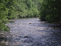
before descending into the Maryville-Alcoa flatlands. As it steadies, the river no longer displays the extreme clarity and attractive rocky bottom of its upper reaches and resembles a more typical stream in a moderately rolling, somewhat rural
area.
The section from the old mill dam below Walland (known locally as Perry's Mill) to the entry into Ft. Loudon Lake— approximately 19 miles— is fully navigable with a canoe under normal conditions. Below Perry's Mill Little River flows through farmland, under U.S. Highway 411, through the cities of Maryville
and Alcoa
and the small community of Rockford
.
Approximately 85,000 residents of these communities draw drinking water from the river. Three creeks— Pistol Creek
, Short Creek and Crooked Creek— join Little River in this area. These three creeks are considered "impaired", contributing to a designation of Little River as "threatened" by the Tennessee Department of Environment and Conservation
. Little River flows into a surprisingly large (given the size of the stream) embayment of the Fort Loudon Lake impoundment of the Tennessee River along U.S. Highway 129, where a small marina
is located. Little River forms the line between Blount County and Knox County
for the last few miles of its course.
River
A river is a natural watercourse, usually freshwater, flowing towards an ocean, a lake, a sea, or another river. In a few cases, a river simply flows into the ground or dries up completely before reaching another body of water. Small rivers may also be called by several other names, including...
in Tennessee
Tennessee
Tennessee is a U.S. state located in the Southeastern United States. It has a population of 6,346,105, making it the nation's 17th-largest state by population, and covers , making it the 36th-largest by total land area...
which drains a 380 square miles (984.2 km²) area containing some of the most spectacular scenery in the southeastern United States
United States
The United States of America is a federal constitutional republic comprising fifty states and a federal district...
. The first 18 miles (29 km) of the river are all located within the borders of the Great Smoky Mountains National Park
Great Smoky Mountains National Park
Great Smoky Mountains National Park is a United States National Park and UNESCO World Heritage Site that straddles the ridgeline of the Great Smoky Mountains, part of the Blue Ridge Mountains, which are a division of the larger Appalachian Mountain chain. The border between Tennessee and North...
. The remaining 33 miles (53.1 km) flow out of the mountains through Blount County
Blount County, Tennessee
Blount County is a U.S. county located in the U.S. state of Tennessee. Its population was 123,010 at the United States Census, 2010. The county seat is at Maryville, which is also the county's largest city....
to join the Tennessee River
Tennessee River
The Tennessee River is the largest tributary of the Ohio River. It is approximately 652 miles long and is located in the southeastern United States in the Tennessee Valley. The river was once popularly known as the Cherokee River, among other names...
at Stock Creek and Fort Loudon Lake in Knox County
Knox County, Tennessee
Knox County is a county in the U.S. state of Tennessee. Its 2007 population was estimated at 423,874 by the United States Census Bureau. Its county seat is Knoxville, as it has been since the creation of the county. The county is at the geographical center of the Great Valley of East Tennessee...
.
Source to Elkmont (7 miles)
Sevier County, Tennessee
Sevier County is a county of the state of Tennessee, United States. Its population was 71,170 at the 2000 United States Census. It is included in the Sevierville, Tennessee, Micropolitan Statistical Area, which is included in the Knoxville-Sevierville-La Follette, TN Combined Statistical Area. The...
inside the national park on the north slope of Clingmans Dome
Clingmans Dome
Clingmans Dome is a mountain in the Great Smoky Mountains of Tennessee and North Carolina, in the southeastern United States. At an elevation of , it is the highest mountain in the Smokies, the highest point in the state of Tennessee, and the highest point along the Appalachian Trail...
, the highest point in Tennessee. Clingmans Dome is located directly on the Tennessee-North Carolina
North Carolina
North Carolina is a state located in the southeastern United States. The state borders South Carolina and Georgia to the south, Tennessee to the west and Virginia to the north. North Carolina contains 100 counties. Its capital is Raleigh, and its largest city is Charlotte...
state line, which parallels the Appalachian Trail
Appalachian Trail
The Appalachian National Scenic Trail, generally known as the Appalachian Trail or simply the AT, is a marked hiking trail in the eastern United States extending between Springer Mountain in Georgia and Mount Katahdin in Maine. It is approximately long...
along the crest of the Smokies. Approximately one mile below its source, Little River absorbs several smaller streams at an area known as Three Forks, where the river gains considerable strength. From here, the river is paralleled by the well-maintained Little River Trail which leads into Elkmont
Elkmont, Tennessee
Elkmont is a region situated in the upper Little River Valley of the Great Smoky Mountains of Sevier County, in the U.S. state of Tennessee. Throughout its history, the valley has been home to a pioneer Appalachian community, a logging town, and a resort community...
. Centered around a valley created by Little River's confluence with Jakes Creek, Elkmont was originally a logging camp for the Little River Lumber Company and a station on the Little River Railroad
Little River Railroad (Tennessee)
The Little River Railroad is a historic class III railroad that operated between Maryville and Elkmont, Tennessee during the period 1901 to 1939.-History:...
. In the 1920s a series of cabins and inholding
Inholding
An inholding is privately owned land inside the boundary of a national park, national forest, state park, or similar publicly owned, protected area...
s, including the Wonderland Hotel
Wonderland Hotel
The Wonderland Hotel was a hotel built in 1911 at Elkmont, Sevier County, Tennessee by the Wonderland Club Company and was dismantled and partially preserved in 2006 by the National Park Service.-History:...
, were leased to private citizens. The leases remained intact until 2001, when the last lease expired.
The road improves at Elkmont to become one which is easily suitable for most vehicles. This section of the river is not navigable, but does offer excellent fishing for native brook trout
Brook trout
The brook trout, Salvelinus fontinalis, is a species of fish in the salmon family of order Salmoniformes. In many parts of its range, it is known as the speckled trout or squaretail. A potamodromous population in Lake Superior are known as coaster trout or, simply, as coasters...
.
Elkmont to the Townsend Y (10 miles)
Gatlinburg, Tennessee
Gatlinburg is a mountain resort city in Sevier County, Tennessee, United States. As of the 2000 U.S. Census, Gatlinburg had a population of 3,828. The city is a popular vacation resort, as it rests on the border of the Great Smoky Mountains National Park along U.S...
and Townsend
Townsend, Tennessee
Townsend is a city in Blount County, Tennessee, in the southeastern United States. The population was 244 at the 2000 census. Townsend is one of three "gateways" to the Great Smoky Mountains National Park and the home of several museums and attractions relating to both the natural and human...
. The stream, like the road that follows it, is quite sinuous. The road is built on the bed of the Little River Railroad that was used for logging
Logging
Logging is the cutting, skidding, on-site processing, and loading of trees or logs onto trucks.In forestry, the term logging is sometimes used in a narrow sense concerning the logistics of moving wood from the stump to somewhere outside the forest, usually a sawmill or a lumber yard...
purposes prior to the establishment of the park.
Waterfall
A waterfall is a place where flowing water rapidly drops in elevation as it flows over a steep region or a cliff.-Formation:Waterfalls are commonly formed when a river is young. At these times the channel is often narrow and deep. When the river courses over resistant bedrock, erosion happens...
s which feed into the river, which especially strong during wet weather. One waterfall, Meigs Falls, is visible from the road and is provided with a parking turnout. Additionally, there are parking turnouts for trails leading to numerous places. About midway between Gatlinburg and Townsend, Little River enters a relatively flat area known as Metcalf Bottoms, which developed along an oasis of soft phyllite
Phyllite
Phyllite is a type of foliated metamorphic rock primarily composed of quartz, sericite mica, and chlorite; the rock represents a gradation in the degree of metamorphism between slate and mica schist. Minute crystals of graphite, sericite, or chlorite impart a silky, sometimes golden sheen to the...
amidst the more predominant sandstone. The park service has established a picnic area at Metcalf Bottoms, providing an attractive area for summer picnics and wading.
Just past Metcalf Bottoms, Little River becomes more rapid and volatile as it slices through Little River Gorge, a narrow valley between Round Top Mountain and Curry She Mountain. Among the gorge's more notable landmarks is an area known as "The Sinks." The Sinks is where the river flows over a ten foot (three meters) waterfall into a large pool, and then seems to disappear for a small distance. (Unlike streams in a limestone
Limestone
Limestone is a sedimentary rock composed largely of the minerals calcite and aragonite, which are different crystal forms of calcium carbonate . Many limestones are composed from skeletal fragments of marine organisms such as coral or foraminifera....
area, which may actually "sink" for a considerable distance, this is more a question of appearance than of the stream truly "sinking", which is not feasible in this area of ancient Precambrian
Precambrian
The Precambrian is the name which describes the large span of time in Earth's history before the current Phanerozoic Eon, and is a Supereon divided into several eons of the geologic time scale...
metamorphic rock
Metamorphic rock
Metamorphic rock is the transformation of an existing rock type, the protolith, in a process called metamorphism, which means "change in form". The protolith is subjected to heat and pressure causing profound physical and/or chemical change...
.) Below the Sinks, Little River is navigable in high water with a kayak.
Continuing to follow TN 73 the stream crosses into Blount County en route to its confluence with Middle Prong of Little River at an area known as the Townsend Y.
The Middle Prong (9 miles)
Tremont, Tennessee
Tremont is a region in the northwestern Great Smoky Mountains National Park, located in the southeastern United States. Formerly home to a pioneer Appalachian community and logging town, Tremont is now the location of the Great Smoky Mountains Institute at Tremont.-Geography:Tremont is situated...
, where it has cut a deep gorge. From here, the river continues northward, absorbing Spruce Flats Branch and several smaller streams before steadying in a relatively flat area known as Walker Valley. The Middle Prong is shadowed by the old roadbed of the Little River Railroad for almost all of its nine mile (14 km) length.
Laurel Creek, which drains the White Oak Sink area, joins the West Prong, which drains the area beneath Spence Field
Spence Field
Spence Field is a highland meadow in the Great Smoky Mountains, located inthe Southeastern United States. It has an elevation of 4,920 feet above sea level...
. The West Prong then joins the Middle Prong a mile east of the Townsend Y at the junction of Tremont Road and Laurel Creek Road.
Only the stream below the Great Smoky Mountains Institute at Tremont is navigable by kayak in high water. Fishing along Middle Prong is considered excellent.
Townsend Y to Walland (14 miles)
Tubing (recreation)
Tubing is a recreational activity where an individual rides on top of an inner tube, either on water, snow, or through the air. The tubes themselves are also known as "donuts" or "biscuits" due to their shape.-Water:Tubing on water generally consists of two forms: towed and free-floating, also...
use the Y as the jumping off point for a mile long float down the river. Just past the Y, Little River exits the Great Smoky Mountains National Park into Tuckaleechee Cove and Townsend. From this point forward, with the exception of two old mill dams, the Little River can be navigated in a kayak at normal water levels. Tubers typically travel from the Townsend Y to the vicinity of the first mill dam (above the Highway 321 bridge). This portion of the river has intermittent rapids and swimming areas, as well as large rocks in middle of the river (such as Gallaher Rock near Cedar Bluff Way) that are suitable to rest at.
In Townsend, the river is paralleled by U.S. Highway 321. Townsend is situated in Tuckaleechee Cove, a Paleozoic
Paleozoic
The Paleozoic era is the earliest of three geologic eras of the Phanerozoic eon, spanning from roughly...
limestone area noted by the presence of Tuckaleechee Caverns, a large cave
Cave
A cave or cavern is a natural underground space large enough for a human to enter. The term applies to natural cavities some part of which is in total darkness. The word cave also includes smaller spaces like rock shelters, sea caves, and grottos.Speleology is the science of exploration and study...
operated as a tourist attraction
Tourist attraction
A tourist attraction is a place of interest where tourists visit, typically for its inherent or exhibited cultural value, historical significance, natural or built beauty, or amusement opportunities....
during the tourist season, roughly defined as April to October. The drainage from the cave enters the Little River just below Townsend.
Townsend is laid out in the cove along the Little River valley. Three decades ago it was largely undeveloped, with a few small "mom and pop" style hotels and restaurants; now major chains have built larger lodging facilities, although not yet comparable to Gatlinburg or Pigeon Forge
Pigeon Forge, Tennessee
Pigeon Forge is a mountain resort city in Sevier County, Tennessee, located in the southeastern United States. As of the 2010 census, the city had a total population of 5,875....
. Of interest are the Little River Railroad and Lumber Company Museum and the Greenway that parallels U.S 321. The Townsend area was once the site of many scenic swinging bridges over Little River; liability
Legal liability
Legal liability is the legal bound obligation to pay debts.* In law a person is said to be legally liable when they are financially and legally responsible for something. Legal liability concerns both civil law and criminal law. See Strict liability. Under English law, with the passing of the Theft...
concerns have caused most of these to be dismantled in recent years. One bridge does remain, however, at the northern end of Townsend in an area known as Kinzel Springs. A second swinging bridge is located near the LRRR&LC Museum and connects to Dark Island.
Little River continues to flow north through Miller Cove into the small community of Walland
Walland, Tennessee
Walland is an unincorporated community in Blount County, Tennessee, in the Southeastern United States. Walland is the site of a post office and is the place name associated with zip code 37886, which covers an area beyond the Walland community...
, which is at the current time the eastern terminus of the Chilhowee section of Foothills Parkway
Foothills Parkway
The Foothills Parkway is a national parkway which, if completed, will traverse the foothills of the northern Great Smoky Mountains in East Tennessee, located in the Southeastern United States. The 71-mile parkway will ideally connect U.S...
, a national parkway
National parkway
National Parkway is a designation for a protected area in the United States. The designation is given to a scenic roadway and a protected corridor of surrounding parkland. National Parkways often connect cultural or historic sites.-See also:...
.
Walland to Fort Loudon Lake (20 miles)
Chilhowee Mountain
Chilhowee Mountain is a low ridge at the outer edge of the Great Smoky Mountains that stretches between the Little Tennessee River to the west and the Little Pigeon River watershed to the east...
before descending into the Maryville-Alcoa flatlands. As it steadies, the river no longer displays the extreme clarity and attractive rocky bottom of its upper reaches and resembles a more typical stream in a moderately rolling, somewhat rural
Rural
Rural areas or the country or countryside are areas that are not urbanized, though when large areas are described, country towns and smaller cities will be included. They have a low population density, and typically much of the land is devoted to agriculture...
area.
The section from the old mill dam below Walland (known locally as Perry's Mill) to the entry into Ft. Loudon Lake— approximately 19 miles— is fully navigable with a canoe under normal conditions. Below Perry's Mill Little River flows through farmland, under U.S. Highway 411, through the cities of Maryville
Maryville, Tennessee
Maryville is the county seat of Blount County, Tennessee, in the Southeastern United States. The city is located south of Knoxville. Maryville's population was 27,258 at the 2010 census. It is included in the Knoxville Metropolitan Area. Maryville has received a number of accolades for its...
and Alcoa
Alcoa, Tennessee
Alcoa is a city in Blount County, Tennessee, United States, south of Knoxville. Its population was 7,744 at the 2000 census. It is part of the Knoxville, Tennessee Metropolitan Statistical Area....
and the small community of Rockford
Rockford, Tennessee
Rockford is a city in Blount County, Tennessee, United States. Its population was 798 at the 2000 census. It is included in the Knoxville, Tennessee Metropolitan Statistical Area.-History:...
.
Approximately 85,000 residents of these communities draw drinking water from the river. Three creeks— Pistol Creek
Pistol Creek
Pistol Creek is a tributary of the Little River, located entirely within Blount County, Tennessee.-Features:Pistol Creek arises from several springs in the Carpenter's Campground section of Blount County, flowing first northeast, then northwest to Pearson Springs within the city of Maryville...
, Short Creek and Crooked Creek— join Little River in this area. These three creeks are considered "impaired", contributing to a designation of Little River as "threatened" by the Tennessee Department of Environment and Conservation
Tennessee Department of Environment and Conservation
The Tennessee Department of Environment and Conservation is a Cabinet-level agency within the government of the U.S. state of Tennessee, headed by the Tennessee Commissioner of Environment and Conservation....
. Little River flows into a surprisingly large (given the size of the stream) embayment of the Fort Loudon Lake impoundment of the Tennessee River along U.S. Highway 129, where a small marina
Marina
A marina is a dock or basin with moorings and supplies for yachts and small boats.A marina differs from a port in that a marina does not handle large passenger ships or cargo from freighters....
is located. Little River forms the line between Blount County and Knox County
Knox County, Tennessee
Knox County is a county in the U.S. state of Tennessee. Its 2007 population was estimated at 423,874 by the United States Census Bureau. Its county seat is Knoxville, as it has been since the creation of the county. The county is at the geographical center of the Great Valley of East Tennessee...
for the last few miles of its course.