

Mount Chapman
Encyclopedia
Great Smoky Mountains
The Great Smoky Mountains are a mountain range rising along the Tennessee–North Carolina border in the southeastern United States. They are a subrange of the Appalachian Mountains, and form part of the Blue Ridge Physiographic Province. The range is sometimes called the Smoky Mountains or the...
, located in the Southeastern United States. It has an elevation of 6,417 feet (1,956 m) above sea level.http://www.peakbagger.com/peak.aspx?pid=7776 While the mountain is located deep within the Great Smokies, the Appalachian Trail
Appalachian Trail
The Appalachian National Scenic Trail, generally known as the Appalachian Trail or simply the AT, is a marked hiking trail in the eastern United States extending between Springer Mountain in Georgia and Mount Katahdin in Maine. It is approximately long...
crosses its eastern slope, coming to within 200 feet (61 m) of the summit. Mount Chapman is among the 10 highest mountains in the Appalachian range
Appalachian Mountains
The Appalachian Mountains #Whether the stressed vowel is or ,#Whether the "ch" is pronounced as a fricative or an affricate , and#Whether the final vowel is the monophthong or the diphthong .), often called the Appalachians, are a system of mountains in eastern North America. The Appalachians...
, if subpeaks are not included.http://www.americasroof.com/6000.shtml
Mount Chapman is situated along the Tennessee
Tennessee
Tennessee is a U.S. state located in the Southeastern United States. It has a population of 6,346,105, making it the nation's 17th-largest state by population, and covers , making it the 36th-largest by total land area...
-North Carolina
North Carolina
North Carolina is a state located in the southeastern United States. The state borders South Carolina and Georgia to the south, Tennessee to the west and Virginia to the north. North Carolina contains 100 counties. Its capital is Raleigh, and its largest city is Charlotte...
border, with Sevier County
Sevier County, Tennessee
Sevier County is a county of the state of Tennessee, United States. Its population was 71,170 at the 2000 United States Census. It is included in the Sevierville, Tennessee, Micropolitan Statistical Area, which is included in the Knoxville-Sevierville-La Follette, TN Combined Statistical Area. The...
to the north and Swain County to the south. Like its neighbor Mount Guyot
Mount Guyot (Great Smoky Mountains)
Mount Guyot is a mountain in the eastern Great Smoky Mountains, located inthe southeastern United States. At above sea level, Guyot is the fourth-highestsummit in the eastern U.S., and the second-highest in the Great Smoky Mountains National Park...
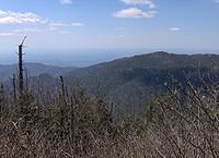
, Chapman is a double-peak, with the southern peak being the true summit. A 1500 feet (457.2 m) gap divides Chapman from Dashoga Ridge (i.e., Mount Hardison and Marks Knob), just two miles (3 km) to the east.http://www.topozone.com/map.asp?lat=35.67911&lon=-83.25962&size=m&u=4&datum=nad27&layer=DRG Mount Chapman's western slope, known as Chapman Lead, is more gradual, descending roughly 4000 feet (1,219.2 m) over 5 miles (8 km) to its base along the headwaters of the Little Pigeon River
Little Pigeon River (Tennessee)
The Little Pigeon River is a river located entirely within Sevier County, Tennessee.It rises from a series of streams which flow together on the dividing ridge between the states of Tennessee and North Carolina inside the boundary of the Great Smoky Mountains National Park. The river is subdivided...
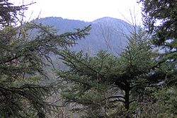
.http://www.topozone.com/map.asp?lat=35.69598&lon=-83.3242&size=m&u=4&datum=nad27&layer=DRG Chapman Lead parallels Guyot Spur to the north, with Buck Fork slicing between the two giant ridges. The mountain's summit is coated in a dense stand of Southern Appalachian spruce-fir forest
Southern Appalachian spruce-fir forest
The Southern Appalachian spruce-fir forest is a type of montane coniferous forest that grows in the highest elevations in the southern Appalachian Mountains of the eastern United States...
.
The remoteness of Mount Chapman has left it largely untouched by human history. The mountain is named after Colonel David C. Chapman
David C. Chapman
David Carpenter Chapman was an American soldier, politician, and business leader from Knoxville, Tennessee who led the effort to establish the Great Smoky Mountains National Park in the 1920s and 1930s. Mount Chapman and Chapman Highway David Carpenter Chapman (9 August 1876 - 26 July 1944) was...
(1876-1944), a Knoxville business leader who led efforts to establish a national park in the Great Smokies. As head of the Tennessee Great Smoky Mountains Park Commission from 1927-1937, Chapman raised funds and negotiated hundreds of land purchases that would make the park possible. Arnold Guyot crossed Mount Chapman in the late 1850's, measuring the mountain's summit at 6,447 feet (Guyot called it "Mount Alexander" after a Princeton colleague). The leg of the Appalachian Trail crossing Chapman's eastern slope was constructed in 1935.
Mount Chapman is approximately 11 miles (17.7 km) from the nearest parking lot at the Cosby Campground and 14.5 miles (23.3 km) from Newfound Gap
Newfound Gap
Newfound Gap is a mountain pass located near the center of the Great Smoky Mountains National Park of the southern Appalachian Mountains in the United States of America. Situated along the border of Tennessee and North Carolina, the state line crosses the gap, as does U.S...
. From the Cosby
Cosby, Tennessee
Cosby is an unincorporated community in Cocke County, Tennessee, United States. Although it is not a census-designated place, the ZIP Code Tabulation Area for the ZIP Code that serves Cosby had a population of 5,201 as of the 2000 U.S. Census...
Campground (specifically behind Campsite B51), the Snake Den Ridge Trail
Snake Den Ridge Trail
The Snake Den Ridge Trail is an American hiking trail in the Great Smoky Mountains National Park of Cocke County, Tennessee. Winding its way up the backbone-like crest of Snake Den Ridge, the trail connects the Cosby Campground to the Appalachian Trail and provides the quickest access to the high...
winds for 5.3 miles (8.5 km) to its junction with the Appalachian Trail at Inadu Knob. Following the AT from Inadu, Chapman's main peak is approximately 5.2 miles (8.4 km) to the south, with the trail first crossing the slopes of Old Black
Old Black (Great Smoky Mountains)
Old Black is a mountain in the Great Smoky Mountains, located in the Southeastern United States. While often overshadowed by Mount Guyot, its higher neighbor to the south, Old Black is the 4th-highest mountain in...
, Mount Guyot
Mount Guyot (Great Smoky Mountains)
Mount Guyot is a mountain in the eastern Great Smoky Mountains, located inthe southeastern United States. At above sea level, Guyot is the fourth-highestsummit in the eastern U.S., and the second-highest in the Great Smoky Mountains National Park...
, and Tricorner Knob
Tricorner Knob
Tricorner Knob is a mountain in the Great Smoky Mountains, located in the Southeastern United States. It has an elevation of 6,120 feet , with 160 feet of clean prominence. The Appalachian Trail and Balsam Mountain Trail intersect near the mountain's summit, making Tricorner Knob the great...
. A short bushwhack is required to reach the summit.
The Tricorner Knob Shelter is approximately 1.5 miles (2.4 km) to the northeast of Mount Chapman.
External links
- Great Smoky Mountains National Park Trail Map - .pdf format
- Mount Chapman - Peakbagger.com
- The Southern Sixers - SummitPost.org
- South Beyond 6000 in the Smokies - Challenge sponsored by the Carolina Hiking Club and the Tennessee Eastman Hiking and Canoeing Club