
Moonee Ponds Creek Trail
Encyclopedia
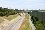
The Moonee Ponds Creek Trail is a shared use path for cyclists
and pedestrian
s, which follows the Moonee Ponds Creek
through the northern suburbs of Melbourne
, Victoria
, Australia
.
on Footscray Road near where the creek enters the Yarra River
. The lower reaches of the path are also the route of the Capital City Trail
.
It follows the creek, snaking under and around the Tullamarine Freeway
for many kilometres. There is a short on road section through Essendon along Vanberg Road. After Bell Street it leaves the Tullamarine Freeway
and the dank concrete environment and heads north on the east side of Essendon Airport
through a series of parks, including the aptly named Boeing
and Charles Kingsford Smith
Ulm
reserves. Passing under the large trestle bridge, the trail soon arrives at the Western Ring Road and the Western Ring Road Trail
.
1.3 km along to the north is Jacana Reserve, near Johnstone Street. By crossing a small footbrige here, one arrives at the south end of the Broadmeadows Valley and the south end of the Broadmeadows Valley Trail
.
Continuing on the Moonee Ponds Creek Trail leads to Willowbrook Reserve near Mickleham Road, in Westmeadows
. West of Willowbrook Reserve, the path continues along the fence line of the Woodlands Historic Park next to Melbourne Airport
.
, Moonee Ponds Creek
, Melbourne Docklands
, Melbourne Airport
.
in the north. Nearby it also intersects the Western Ring Road Trail
and meets the Capital City Trail
in the south.
Heading east 1km along the Western Ring Road Trail
will take you to Jacana station and further still to the Merri Creek Trail
at Fawkner
. Heading west along the Western Ring Road Trail
will lead you to Brimbank Park and the Maribyrnong River Trail
.
North end at 37.665319°S 144.869263°E.
South end at 37.787553°S 144.939947°E.
Cycling
Cycling, also called bicycling or biking, is the use of bicycles for transport, recreation, or for sport. Persons engaged in cycling are cyclists or bicyclists...
and pedestrian
Pedestrian
A pedestrian is a person traveling on foot, whether walking or running. In some communities, those traveling using roller skates or skateboards are also considered to be pedestrians. In modern times, the term mostly refers to someone walking on a road or footpath, but this was not the case...
s, which follows the Moonee Ponds Creek
Moonee Ponds Creek
The Moonee Ponds Creek is a creek and major tributary of the Yarra River running through urban Melbourne, Victoria, Australia from northern to inner suburbs...
through the northern suburbs of Melbourne
Melbourne
Melbourne is the capital and most populous city in the state of Victoria, and the second most populous city in Australia. The Melbourne City Centre is the hub of the greater metropolitan area and the Census statistical division—of which "Melbourne" is the common name. As of June 2009, the greater...
, Victoria
Victoria (Australia)
Victoria is the second most populous state in Australia. Geographically the smallest mainland state, Victoria is bordered by New South Wales, South Australia, and Tasmania on Boundary Islet to the north, west and south respectively....
, Australia
Australia
Australia , officially the Commonwealth of Australia, is a country in the Southern Hemisphere comprising the mainland of the Australian continent, the island of Tasmania, and numerous smaller islands in the Indian and Pacific Oceans. It is the world's sixth-largest country by total area...
.
Following the path
It commences in Melbourne DocklandsMelbourne Docklands
Docklands is an inner city suburb in Melbourne, Victoria, Australia occupying an area extending up to 2 km west of and adjacent to Melbourne's Central Business District . Its Local Government Area is the City of Melbourne...
on Footscray Road near where the creek enters the Yarra River
Yarra River
The Yarra River, originally Birrarung, is a river in east-central Victoria, Australia. The lower stretches of the river is where the city of Melbourne was established in 1835 and today Greater Melbourne dominates and influences the landscape of its lower reaches...
. The lower reaches of the path are also the route of the Capital City Trail
Capital City Trail
The Capital City Trail is a shared use path for cyclists and pedestrians, which circles the Melbourne city centre and some inner eastern and northern suburbs of Melbourne, Victoria, Australia....
.
It follows the creek, snaking under and around the Tullamarine Freeway
Tullamarine Freeway
The Tullamarine Freeway is an urban freeway in Melbourne, Australia, linking Melbourne Airport to the central business district.-History:Tullamarine Freeway is one of the oldest freeways in Melbourne, originally constructed in 1968-1970...
for many kilometres. There is a short on road section through Essendon along Vanberg Road. After Bell Street it leaves the Tullamarine Freeway
Tullamarine Freeway
The Tullamarine Freeway is an urban freeway in Melbourne, Australia, linking Melbourne Airport to the central business district.-History:Tullamarine Freeway is one of the oldest freeways in Melbourne, originally constructed in 1968-1970...
and the dank concrete environment and heads north on the east side of Essendon Airport
Essendon Airport
Essendon Airport is located at Essendon, in Melbourne's northern suburbs, Victoria, Australia. It is located next to the Tullamarine Freeway on , from the Melbourne Central Business District and from Melbourne Airport.-History:...
through a series of parks, including the aptly named Boeing
Boeing
The Boeing Company is an American multinational aerospace and defense corporation, founded in 1916 by William E. Boeing in Seattle, Washington. Boeing has expanded over the years, merging with McDonnell Douglas in 1997. Boeing Corporate headquarters has been in Chicago, Illinois since 2001...
and Charles Kingsford Smith
Charles Kingsford Smith
Sir Charles Edward Kingsford Smith MC, AFC , often called by his nickname Smithy, was an early Australian aviator. In 1928, he earned global fame when he made the first trans-Pacific flight from the United States to Australia...
Ulm
Charles Ulm
Charles Thomas Philippe Ulm AFC was a pioneer Australian aviator.-World War I:Ulm joined the AIF in September 1914, lying about his name and age to get in. He fought and was wounded at Gallipoli in 1915, and on the Western Front in 1918.Charles Ulm was married twice. In 1919 he married Isabel...
reserves. Passing under the large trestle bridge, the trail soon arrives at the Western Ring Road and the Western Ring Road Trail
Western Ring Road Trail
The Western Ring Road Trail is a shared use path for cyclists and pedestrians that bridges the northern suburbs and follows the Western Ring Road...
.
1.3 km along to the north is Jacana Reserve, near Johnstone Street. By crossing a small footbrige here, one arrives at the south end of the Broadmeadows Valley and the south end of the Broadmeadows Valley Trail
Broadmeadows Valley Trail
The Broadmeadows Valley Trail is a shared use path for cyclists and pedestrians in the outer northern suburbs of Melbourne, Victoria, Australia.While in Craigieburn consider a side trip to Mount Ridley or a return trip via the Craigieburn Bypass Trail....
.
Continuing on the Moonee Ponds Creek Trail leads to Willowbrook Reserve near Mickleham Road, in Westmeadows
Westmeadows, Victoria
Westmeadows is a suburb in Melbourne, Victoria, Australia, 17 km north from Melbourne's central business district. Its Local Government Area is the City of Hume. At the 2006 Census, Westmeadows had a population of 5,857....
. West of Willowbrook Reserve, the path continues along the fence line of the Woodlands Historic Park next to Melbourne Airport
Melbourne Airport
Melbourne Airport , also known as Tullamarine Airport, is the primary airport serving the city of Melbourne and the second busiest in Australia. It was opened in 1970 to replace the nearby Essendon Airport. Melbourne Airport is the sole international airport of the four airports serving the...
.
Landmarks
Tullamarine FreewayTullamarine Freeway
The Tullamarine Freeway is an urban freeway in Melbourne, Australia, linking Melbourne Airport to the central business district.-History:Tullamarine Freeway is one of the oldest freeways in Melbourne, originally constructed in 1968-1970...
, Moonee Ponds Creek
Moonee Ponds Creek
The Moonee Ponds Creek is a creek and major tributary of the Yarra River running through urban Melbourne, Victoria, Australia from northern to inner suburbs...
, Melbourne Docklands
Melbourne Docklands
Docklands is an inner city suburb in Melbourne, Victoria, Australia occupying an area extending up to 2 km west of and adjacent to Melbourne's Central Business District . Its Local Government Area is the City of Melbourne...
, Melbourne Airport
Melbourne Airport
Melbourne Airport , also known as Tullamarine Airport, is the primary airport serving the city of Melbourne and the second busiest in Australia. It was opened in 1970 to replace the nearby Essendon Airport. Melbourne Airport is the sole international airport of the four airports serving the...
.
Connections
The trail intersects the Broadmeadows Valley TrailBroadmeadows Valley Trail
The Broadmeadows Valley Trail is a shared use path for cyclists and pedestrians in the outer northern suburbs of Melbourne, Victoria, Australia.While in Craigieburn consider a side trip to Mount Ridley or a return trip via the Craigieburn Bypass Trail....
in the north. Nearby it also intersects the Western Ring Road Trail
Western Ring Road Trail
The Western Ring Road Trail is a shared use path for cyclists and pedestrians that bridges the northern suburbs and follows the Western Ring Road...
and meets the Capital City Trail
Capital City Trail
The Capital City Trail is a shared use path for cyclists and pedestrians, which circles the Melbourne city centre and some inner eastern and northern suburbs of Melbourne, Victoria, Australia....
in the south.
Heading east 1km along the Western Ring Road Trail
Western Ring Road Trail
The Western Ring Road Trail is a shared use path for cyclists and pedestrians that bridges the northern suburbs and follows the Western Ring Road...
will take you to Jacana station and further still to the Merri Creek Trail
Merri Creek Trail
The Merri Creek Trail is a shared use path for cyclists and pedestrians, which follows the Merri Creek through the northern suburbs of Melbourne, Victoria, Australia.-Following the Path:...
at Fawkner
Fawkner, Victoria
Fawkner is a suburb in Melbourne, Victoria, Australia, 12 km north from Melbourne's central business district. Its Local Government Area is the City of Moreland...
. Heading west along the Western Ring Road Trail
Western Ring Road Trail
The Western Ring Road Trail is a shared use path for cyclists and pedestrians that bridges the northern suburbs and follows the Western Ring Road...
will lead you to Brimbank Park and the Maribyrnong River Trail
Maribyrnong River Trail
The Maribyrnong River Trail is a shared use path for cyclists and pedestrians, which follows the Maribyrnong River through the north western suburbs of Melbourne, Victoria, Australia....
.
North end at 37.665319°S 144.869263°E.
South end at 37.787553°S 144.939947°E.