

Tullamarine Freeway
Encyclopedia
The 
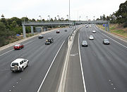
 Tullamarine Freeway is an urban freeway in Melbourne
, Australia
, linking Melbourne Airport
to the central business district
.
and parts of Bulla Road, Essendon
, providing easy access to the newly built Melbourne Airport
. A spur was constructed to link with the Calder Highway
at Airport West
. From Essendon, a new section heading east to Pascoe Vale
and then south along the Moonee Ponds Creek
to Mt Alexander Road, Flemington
replaced Mount Alexander Road as the main route to the city.
The freeway was initially designated for the whole stretch from Tullamarine to Flemington. The short Calder Highway link was designated the Calder Freeway
 . The freeway was originally designated in the 1969 Melbourne Transportation Plan
as the F14 Freeway corridor.
With its completion, citybound heavy vehicles from Hume Highway
were diverted here via Pascoe Vale Road. In the 1990s, the completion of the Western Ring Road increased traffic tremendously. It was only relieved by the completion of CityLink
, widening the freeway to 8 lanes (two of these being transit lanes) and extending it south to the West Gate Freeway
. The improved sections are now tolled.
The freeway is used by Skybus Super Shuttle
services to Melbourne Airport, and in 2002 the Victorian government
contributed $3 million to a $10 million plan to expand and improve these services, after a feasibility study into an airport rail link
found the number of passengers using a train would not make the scheme economically viable.
The Calder Freeway
interchange was completed earlier than expected in mid 2007, which underwent dramatic roadworks to alleviate congestion. All works are now complete, with the end result being the decommissioning and removal of two offramps, an additional two lanes inbound, and dedicated Bulla Road-Calder Freeway spurs to eliminate weaving, notorious for many accidents in the area.
Another project now completed is a new bridge and northern entrance to the Essendon Airport through the interchange of Melrose Drive, to provide easy access for the people living in the northern suburbs to access the Essendon Airport district.
VicRoads is currently changing the route sign to.
 Today the official start of the freeway is at Pascoe Vale Road
, as the original southern sections was upgraded in the late 1990s as part of CityLink
. Here it is a three lane, high quality dual carriageway, running along the south side of Essendon Airport
and the Direct Factory Outlets shopping complex, the former main airport of Melbourne. At the Calder Freeway
interchange, staying to the right will lead you to the next section of the Tullamarine Freeway.
The next section is quite narrow, with two lanes running either way and a concrete barrier (later grass and shrubbery) in the middle of the road. Melrose Drive runs alongside its airport-bound side. This section is frequently congested due to the combination of freight traffic from the Hume Highway
, which is accessed from the Western Ring Road interchange, and the traffic from the airport. After the ring road interchange, the traffic is slightly better, leading to the Melbourne Airport off ramp, after which the freeway ends.
Tullamarine Freeway is an urban freeway in MelbourneMelbourne
Melbourne is the capital and most populous city in the state of Victoria, and the second most populous city in Australia. The Melbourne City Centre is the hub of the greater metropolitan area and the Census statistical division—of which "Melbourne" is the common name. As of June 2009, the greater...
, Australia
Australia
Australia , officially the Commonwealth of Australia, is a country in the Southern Hemisphere comprising the mainland of the Australian continent, the island of Tasmania, and numerous smaller islands in the Indian and Pacific Oceans. It is the world's sixth-largest country by total area...
, linking Melbourne Airport
Melbourne Airport
Melbourne Airport , also known as Tullamarine Airport, is the primary airport serving the city of Melbourne and the second busiest in Australia. It was opened in 1970 to replace the nearby Essendon Airport. Melbourne Airport is the sole international airport of the four airports serving the...
to the central business district
Melbourne city centre
Melbourne City Centre is an area of Melbourne in Victoria, Australia. It is not to be confused with the larger local government area of the City of Melbourne...
.
History
Tullamarine Freeway is one of the oldest freeways in Melbourne, originally constructed in 1968-1970. It was intended to replace Lancefield Road (now Melrose Drive), TullamarineTullamarine, Victoria
Tullamarine is a suburb in Melbourne, Victoria, Australia, 17 km north-west from Melbourne's central business district. Its Local Government Area are the Cities of Hume, Brimbank and Moreland. At the 2006 Census, Tullamarine had a population of 6,541....
and parts of Bulla Road, Essendon
Essendon, Victoria
Essendon is a suburb in Melbourne, Victoria, Australia, 10 km north-west from Melbourne's central business district. Its Local Government Area is the City of Moonee Valley...
, providing easy access to the newly built Melbourne Airport
Melbourne Airport
Melbourne Airport , also known as Tullamarine Airport, is the primary airport serving the city of Melbourne and the second busiest in Australia. It was opened in 1970 to replace the nearby Essendon Airport. Melbourne Airport is the sole international airport of the four airports serving the...
. A spur was constructed to link with the Calder Highway
Calder Highway
Calder Highway is a Highway linking Ravenswood South in Victoria, to Mildura. North of the Victoria/New South Wales border, the highway continues north to Broken Hill, Tibooburra and the New South Wales/Queensland border as the Silver City Highway, under the standard national route shield as far...
at Airport West
Airport West, Victoria
Airport West is a suburb 14 km north-west of Melbourne, Victoria, Australia. Its Local Government Area is the City of Moonee Valley. At the 2006 Census, Airport West had a population of 6660....
. From Essendon, a new section heading east to Pascoe Vale
Pascoe Vale, Victoria
Pascoe Vale is a western suburb of Melbourne, Victoria, Australia, 10 km north from Melbourne's central business district. Its Local Government Area is the City of Moreland. At the 2006 Census, Pascoe Vale had a population of 13,558.- History :...
and then south along the Moonee Ponds Creek
Moonee Ponds Creek
The Moonee Ponds Creek is a creek and major tributary of the Yarra River running through urban Melbourne, Victoria, Australia from northern to inner suburbs...
to Mt Alexander Road, Flemington
Flemington, Victoria
Flemington is a suburb in Melbourne, Victoria, Australia, situated between the Maribyrnong River and Moonee Ponds Creek 4 km north-west from Melbourne's central business district. It was named by settler James Watson after Flemington estate in Scotland. Its Local Government Areas are the...
replaced Mount Alexander Road as the main route to the city.
The freeway was initially designated
for the whole stretch from Tullamarine to Flemington. The short Calder Highway link was designated the Calder FreewayCalder Freeway
Calder Freeway is a freeway linking Melbourne to Ravenswood South in Victoria, Australia, superseding stretches of the Calder Highway. Originally just a short spur of the Tullamarine Freeway linking to the Calder Highway in Keilor in suburban Melbourne, it has been extended in phases to Ravenswood...
. The freeway was originally designated in the 1969 Melbourne Transportation Plan1969 Melbourne Transportation Plan
The 1969 Melbourne Transportation Plan was a road and rail transport plan for Melbourne, the state capital of Victoria, Australia instituted by Henry Bolte's state government...
as the F14 Freeway corridor.
With its completion, citybound heavy vehicles from Hume Highway
Hume Highway
The Hume Highway/Hume Freeway is one of Australia's major inter-city highways, running for 880 km between Sydney and Melbourne. It is part of the Auslink National Network and is a vital link for road freight to transport goods to and from the two cities as well as serving Albury-Wodonga and...
were diverted here via Pascoe Vale Road. In the 1990s, the completion of the Western Ring Road increased traffic tremendously. It was only relieved by the completion of CityLink
CityLink
CityLink is a system of tolled urban Highways in Melbourne, Victoria, Australia. The company Transurban was awarded the contract to augment two existing freeways and construct two new Toll roads—labelled the Western and Southern Links—directly linking a number of existing freeways to...
, widening the freeway to 8 lanes (two of these being transit lanes) and extending it south to the West Gate Freeway
West Gate Freeway
West Gate Freeway is a freeway in Melbourne, Australia, linking Geelong to Melbourne CBD and beyond. It is also a link between Melbourne and the west and linking industrial and residential areas west of the Yarra River with the city and port areas. The iconic West Gate Bridge is a part of the...
. The improved sections are now tolled.
The freeway is used by Skybus Super Shuttle
Skybus Super Shuttle
The Skybus Shuttle is an Australian airport bus service that runs between Melbourne Airport at Tullamarine and Southern Cross Station in the city of Melbourne. In 2008, Skybus carried over 1.6 million passengers a year....
services to Melbourne Airport, and in 2002 the Victorian government
Government of Victoria
The Government of Victoria, under the Constitution of Australia, ceded certain legislative and judicial powers to the Commonwealth, but retained complete independence in all other areas...
contributed $3 million to a $10 million plan to expand and improve these services, after a feasibility study into an airport rail link
Airport rail link
An airport rail link is a service providing passenger rail transport from an airport to a nearby city; by mainline- or commuter trains, rapid transit, people mover or light rail...
found the number of passengers using a train would not make the scheme economically viable.
The Calder Freeway
Calder Freeway
Calder Freeway is a freeway linking Melbourne to Ravenswood South in Victoria, Australia, superseding stretches of the Calder Highway. Originally just a short spur of the Tullamarine Freeway linking to the Calder Highway in Keilor in suburban Melbourne, it has been extended in phases to Ravenswood...
interchange was completed earlier than expected in mid 2007, which underwent dramatic roadworks to alleviate congestion. All works are now complete, with the end result being the decommissioning and removal of two offramps, an additional two lanes inbound, and dedicated Bulla Road-Calder Freeway spurs to eliminate weaving, notorious for many accidents in the area.
Another project now completed is a new bridge and northern entrance to the Essendon Airport through the interchange of Melrose Drive, to provide easy access for the people living in the northern suburbs to access the Essendon Airport district.
VicRoads is currently changing the route sign to
.Route
Pascoe Vale Road, Melbourne
Pascoe Vale Road is a major thoroughfare through the inner northern suburbs of Melbourne continuing to the outer northern suburbs. It runs in the South from its junction with Mount Alexander Road at Moonee Ponds Junction and continues North through the suburbs of Moonee Ponds, Essendon, Strathmore,...
, as the original southern sections was upgraded in the late 1990s as part of CityLink
CityLink
CityLink is a system of tolled urban Highways in Melbourne, Victoria, Australia. The company Transurban was awarded the contract to augment two existing freeways and construct two new Toll roads—labelled the Western and Southern Links—directly linking a number of existing freeways to...
. Here it is a three lane, high quality dual carriageway, running along the south side of Essendon Airport
Essendon Airport
Essendon Airport is located at Essendon, in Melbourne's northern suburbs, Victoria, Australia. It is located next to the Tullamarine Freeway on , from the Melbourne Central Business District and from Melbourne Airport.-History:...
and the Direct Factory Outlets shopping complex, the former main airport of Melbourne. At the Calder Freeway
Calder Freeway
Calder Freeway is a freeway linking Melbourne to Ravenswood South in Victoria, Australia, superseding stretches of the Calder Highway. Originally just a short spur of the Tullamarine Freeway linking to the Calder Highway in Keilor in suburban Melbourne, it has been extended in phases to Ravenswood...
interchange, staying to the right will lead you to the next section of the Tullamarine Freeway.
The next section is quite narrow, with two lanes running either way and a concrete barrier (later grass and shrubbery) in the middle of the road. Melrose Drive runs alongside its airport-bound side. This section is frequently congested due to the combination of freight traffic from the Hume Highway
Hume Highway
The Hume Highway/Hume Freeway is one of Australia's major inter-city highways, running for 880 km between Sydney and Melbourne. It is part of the Auslink National Network and is a vital link for road freight to transport goods to and from the two cities as well as serving Albury-Wodonga and...
, which is accessed from the Western Ring Road interchange, and the traffic from the airport. After the ring road interchange, the traffic is slightly better, leading to the Melbourne Airport off ramp, after which the freeway ends.
Exits and intersections
| Tullamarine Freeway |
|||
| Northbound exits | Distance to Melbourne Airport (km) |
Distance to Melbourne CBD (km) |
Southbound exits |
| End Tullamarine Freeway continues as Sunbury Road to Sunbury Sunbury, Victoria Sunbury is a regional city, located north-west of Melbourne's central business district, in the state of Victoria, Australia. Its Local Government Area is the City of Hume. At the 2006 Census, Sunbury had a population of 31,000... |
-- | 23 | Start Tullamarine Freeway from Sunbury Road |
| Melbourne Airport Melbourne Airport, Victoria Melbourne Airport is a suburb in Melbourne, Victoria, Australia, 19 km north-west from Melbourne's central business district. Its Local Government Area is the City of Hume. At the 2006 Census, Melbourne Airport had a population of 18... Centre Road  |
|||
| Melbourne Airport Melbourne Airport, Victoria Melbourne Airport is a suburb in Melbourne, Victoria, Australia, 19 km north-west from Melbourne's central business district. Its Local Government Area is the City of Hume. At the 2006 Census, Melbourne Airport had a population of 18... Terminal Drive |
1 | 22 | no exit |
| Mercer Drive | 2 | 21 | no exit |
| Tullamarine Tullamarine, Victoria Tullamarine is a suburb in Melbourne, Victoria, Australia, 17 km north-west from Melbourne's central business district. Its Local Government Area are the Cities of Hume, Brimbank and Moreland. At the 2006 Census, Tullamarine had a population of 6,541.... , Mickleham Mickleham, Victoria Mickleham is a locality within Greater Melbourne, Victoria, Australia, 32 km north from Melbourne's central business district beyond the Urban Growth Boundary. Its Local Government Area is the City of Hume... Mickleham Road Mickleham Road, Melbourne Mickleham Road is a secondary road located in Victoria, Australia, north of Melbourne.-Route:Mickleham Road begins at an intersection with Melrose Drive and Broadmeadows Road in Tullamarine, and continues north through the suburbs of Gladstone Park, Westmeadows, Attwood, Greenvale, Yuroke and...   |
4 | 19 | Mickleham Mickleham, Victoria Mickleham is a locality within Greater Melbourne, Victoria, Australia, 32 km north from Melbourne's central business district beyond the Urban Growth Boundary. Its Local Government Area is the City of Hume... , Tullamarine Tullamarine, Victoria Tullamarine is a suburb in Melbourne, Victoria, Australia, 17 km north-west from Melbourne's central business district. Its Local Government Area are the Cities of Hume, Brimbank and Moreland. At the 2006 Census, Tullamarine had a population of 6,541.... Mickleham Road Mickleham Road, Melbourne Mickleham Road is a secondary road located in Victoria, Australia, north of Melbourne.-Route:Mickleham Road begins at an intersection with Melrose Drive and Broadmeadows Road in Tullamarine, and continues north through the suburbs of Gladstone Park, Westmeadows, Attwood, Greenvale, Yuroke and... |
| no exit | 5.5 | 17.5 | Seymour Seymour, Victoria Seymour is a township in the Shire of Mitchell in the state of Victoria, Australia and is located north of Melbourne. At the 2006 census, Seymour had a population of 6,063... , Sydney Sydney Sydney is the most populous city in Australia and the state capital of New South Wales. Sydney is located on Australia's south-east coast of the Tasman Sea. As of June 2010, the greater metropolitan area had an approximate population of 4.6 million people... Western Ring Road  |
| Seymour Seymour, Victoria Seymour is a township in the Shire of Mitchell in the state of Victoria, Australia and is located north of Melbourne. At the 2006 census, Seymour had a population of 6,063... , Sydney Sydney Sydney is the most populous city in Australia and the state capital of New South Wales. Sydney is located on Australia's south-east coast of the Tasman Sea. As of June 2010, the greater metropolitan area had an approximate population of 4.6 million people... Western Ring Road |
6 | 17 | To Airport West Airport West, Victoria Airport West is a suburb 14 km north-west of Melbourne, Victoria, Australia. Its Local Government Area is the City of Moonee Valley. At the 2006 Census, Airport West had a population of 6660.... Geelong, Bendigo, Adelaide Adelaide Adelaide is the capital city of South Australia and the fifth-largest city in Australia. Adelaide has an estimated population of more than 1.2 million... Western Ring Road |
| ALBION-JACANA FREIGHT RAIL LINE | 6.5 | 16.5 | ALBION-JACANA FREIGHT RAIL LINE |
| Airport West Airport West, Victoria Airport West is a suburb 14 km north-west of Melbourne, Victoria, Australia. Its Local Government Area is the City of Moonee Valley. At the 2006 Census, Airport West had a population of 6660.... Melrose Drive |
7 | 16 | Essendon Airport Essendon Airport Essendon Airport is located at Essendon, in Melbourne's northern suburbs, Victoria, Australia. It is located next to the Tullamarine Freeway on , from the Melbourne Central Business District and from Melbourne Airport.-History:... Wirraway Road |
| Airport West Airport West, Victoria Airport West is a suburb 14 km north-west of Melbourne, Victoria, Australia. Its Local Government Area is the City of Moonee Valley. At the 2006 Census, Airport West had a population of 6660.... , Essendon Airport Essendon Airport Essendon Airport is located at Essendon, in Melbourne's northern suburbs, Victoria, Australia. It is located next to the Tullamarine Freeway on , from the Melbourne Central Business District and from Melbourne Airport.-History:... Matthews Avenue/English Street |
8 | 15 | Essendon Airport Essendon Airport Essendon Airport is located at Essendon, in Melbourne's northern suburbs, Victoria, Australia. It is located next to the Tullamarine Freeway on , from the Melbourne Central Business District and from Melbourne Airport.-History:... , Niddrie Niddrie, Victoria Niddrie is a suburb in Melbourne, Victoria, Australia, 13 km north-west from Melbourne's central business district. Its Local Government Area is the City of Moonee Valley... English Street/Matthews Avenue |
| Keilor Keilor, Victoria Keilor is a suburb in Melbourne, Victoria, Australia, 18 km north-west from Melbourne's central business district. Its Local Government Area are the Cities of Brimbank and Hume... , Bendigo Bendigo, Victoria Bendigo is a major regional city in the state of Victoria, Australia, located very close to the geographical centre of the state and approximately north west of the state capital Melbourne. It is the second largest inland city and fourth most populous city in the state. The estimated urban... Calder Freeway Calder Freeway Calder Freeway is a freeway linking Melbourne to Ravenswood South in Victoria, Australia, superseding stretches of the Calder Highway. Originally just a short spur of the Tullamarine Freeway linking to the Calder Highway in Keilor in suburban Melbourne, it has been extended in phases to Ravenswood...   |
9.5 | 13.5 | Essendon Essendon, Victoria Essendon is a suburb in Melbourne, Victoria, Australia, 10 km north-west from Melbourne's central business district. Its Local Government Area is the City of Moonee Valley... , Moonee Ponds Moonee Ponds, Victoria Moonee Ponds is a suburb in Melbourne, Victoria, Australia, 7 km north-west from Melbourne's central business district. Its Local Government Area is the City of Moonee Valley.It is home to Queens Park and the Moonee Valley Racecourse... Bulla Road  |
| Niddrie Niddrie, Victoria Niddrie is a suburb in Melbourne, Victoria, Australia, 13 km north-west from Melbourne's central business district. Its Local Government Area is the City of Moonee Valley... , Essendon Essendon, Victoria Essendon is a suburb in Melbourne, Victoria, Australia, 10 km north-west from Melbourne's central business district. Its Local Government Area is the City of Moonee Valley... Bulla Road |
11 | 12 | Coburg Coburg, Victoria Coburg is a suburb in Melbourne, Victoria, Australia, 8 km north from Melbourne's central business district. Its Local Government Area is the City of Moreland, although a handful of properties on Coburg's Eastern boundary are located in the City of Darebin... , Heidelberg Heidelberg, Victoria Heidelberg is a suburb in Melbourne, Victoria, Australia, 11 km north-east from Melbourne's central business district. Its Local Government Area is the City of Banyule.... Bell Street |
| Start Tullamarine Freeway continues from CityLink CityLink CityLink is a system of tolled urban Highways in Melbourne, Victoria, Australia. The company Transurban was awarded the contract to augment two existing freeways and construct two new Toll roads—labelled the Western and Southern Links—directly linking a number of existing freeways to... |
13 | 10 | End Tullamarine Freeway continues as CityLink CityLink CityLink is a system of tolled urban Highways in Melbourne, Victoria, Australia. The company Transurban was awarded the contract to augment two existing freeways and construct two new Toll roads—labelled the Western and Southern Links—directly linking a number of existing freeways to... to Melbourne Melbourne Melbourne is the capital and most populous city in the state of Victoria, and the second most populous city in Australia. The Melbourne City Centre is the hub of the greater metropolitan area and the Census statistical division—of which "Melbourne" is the common name. As of June 2009, the greater... |
See also
- Freeways in AustraliaFreeways in AustraliaThis is a list of freeways and motorways in Australia, sorted by states and territories and their corresponding routes. This list includes toll roads such as the CityLink freeway system in Melbourne. This list has over 70 entries...
- Freeways in Melbourne
- Road transport in Victoria