

Minnesota State Highway 100
Encyclopedia
Minnesota State Highway 100 (MN 100) is a state highway
in the Twin Cities region of Minnesota
, which runs from its interchange
with Interstate 494
(I-494) in Bloomington
and continues north to its northern terminus at its interchange with I-694
in Brooklyn Center
. The southern end of MN 100 continues in Bloomington as Normandale Boulevard (County Road 34, CR 34). At the north end, the main line of MN 100 merges with I-694 in Brooklyn Center. The route is 16 miles (25.7 km) in length.
, St. Louis Park
, Golden Valley
, Crystal
, Robbinsdale
, and Brooklyn Center. MN 100 is constructed to freeway standards. The route is located in Hennepin County
.
All of the current MN 100 was also in the original route. Starting from the current southern terminus, Old MN 100 was concurrent
eastward with a pre-I-494 MN 5
past the Minneapolis-Saint Paul International Airport to its intersection with MN 55
. Old MN 100 then continued east concurrent with MN 55 over the Mendota Bridge, then along current MN 110
through Mendota Heights
, then MN 100 went on Southview Boulevard into South St. Paul
. Then old MN 100 followed Grand Avenue downhill, until it met old MN 56
on Concord Street. Then old MN 100 followed south on Concord Street into Inver Grove Heights
, then east over the railroad bridge into Newport
; and then turning north onto Century Avenue in Woodbury
, which feeds into current MN 120
north of I-94
in Maplewood
/ Oakdale
. Old MN 100 then turned west upon County Road F and north along White Bear Avenue to meet up with and concurrent westward with old MN 96
(the section of which is now County Highway 96 in Vadnais Heights
and Shoreview
). Old MN 100 then turned south briefly along U.S. Highway 8 (US 8, now a city maintained street in New Brighton
), then old MN 100 carried on westward along the current routing of I-694 through New Brighton and Fridley
to meet back at its present day northern terminus at Brooklyn Center
.
Due to traffic pattern changes over the years, it is no longer possible to directly follow the path of old MN 100. Small detours are necessary which involve the use of exits 40 and 60 of the present I-494/I-694 beltway.
 The original construction of MN 100 started in 1935, as a New Deal
project. The project was a cooperative venture between the Works Progress Administration
(WPA) and the Minnesota Highway Department, and was the largest WPA project in the state. The demand for the highway came out of growing pains in the Twin Cities during the 1920s, when Minneapolis city streets were congested and suburban roads were poorly maintained dirt roads. The plan for a beltway around the Twin Cities incorporated existing roads, both paved and unpaved. A new section of highway, between MN 5 (now I-494 and MN 5) in Edina and then-US 52
(now CR 81
) in Robbinsdale
was needed to complete the beltway. As such, it was planned as a state-of-the-art highway, with two lanes in each direction separated by wide medians, bridges at major intersections and railroad crossings, and the first cloverleaf interchange
s in Minnesota.
Carl Graeser, the highway engineer, and Arthur Nichols, a landscaper, teamed up to design the highway. A large number of WPA workers worked on the construction of the highway. Since the WPA was designed to keep a large number of workers busy, a lot of hand digging was done as opposed to using bulldozers. Cloverleaf interchanges were built at MN 7
, US 12
(now I-394), and MN 55 (Olson Highway).
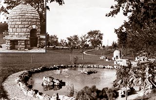
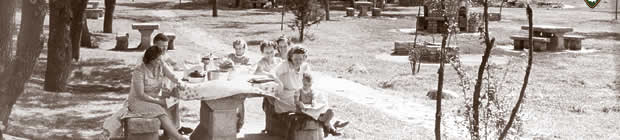
The landscaping of the highway was meant to give the highway a parkway-like experience. As such, it was built with a wider right-of-way than the typical highway. The Golden Valley Garden Club supported efforts to plant lilacs along the highway, and the Minneapolis Journal coined the name "Lilac Way". Eventually, 7,000 lilacs were planted. In addition, the builders built five wayside parks along the way. These parks were intended for picnicking and featured stone picnic tables, beehive barbecues, waterfalls, and so on. These fixtures provided work for local stonemasons, as another part of the WPA project. The western leg was completed in 1940, but further construction on the beltway was halted with the United States' entry into World War II
. An extension from then-US 52 (now CR 81) in Robbinsdale to US 10
(near present day I-35W
) in New Brighton
was built with federal aid to provide access to industrial areas as an asset to the manufacture of "essential war materials".
 Graeser Park in Robbinsdale and the St. Louis Park Roadside Park (near the southeast corner of MN 100 and MN 7) are the only remaining roadside parks from the 1930s that are still mostly intact after widening of MN 100.
The beltline was not completed until 1950. At that point, demand from the baby boom
led to rapid growth in the suburbs.
In 2009, restoration of the St. Louis Park Roadside Park was completed, and the park renamed Lilac Park. As part of the restoration project, a beehive fireplace from the old Lilac Park to the north was transferred and restored. A new bicycle/walkway path constructed within the park connects the park to the Southwest LRT Trail
.
The cloverleaf interchange at MN 55 in Golden Valley was changed and rebuilt in 2004 as a signalized single-point urban interchange
(SPUI).
In 2006, a "temporary" third lane was built in St. Louis Park, between Excelsior Boulevard and Cedar Lake Road. This section of the highway, which was two lanes, has been a bottleneck for many years. Creating the third lane involved narrowing the left and right shoulders while retaining the existing bridges of the Twin Cities and Western Railroad
, Southwest LRT Trail
(formerly the Minneapolis and St. Louis Railway
), MN 7, and Minnetonka Boulevard (CR 5). The cloverleaf interchange at MN 7 / CR 25 was replaced with a folded diamond interchange. Unfortunately, a small bottleneck around the MN 7 / CR 25 interchange remains southbound. Permanent reconstruction was slated to begin in 2010, which would replace and widen the existing bridges, but because of cutbacks in funding that project has been pushed back to 2014.
With the freeway upgrade completed in 2004 between 36th Avenue North (at Crystal–Robbinsdale) and Brooklyn Boulevard (at Brooklyn Center), MN 100 incidentally had both the oldest (the segment of freeway between Excelsior Boulevard and I-394) and newest freeway segments in the Twin Cities from 2004 to 2008. Since then, a new 12 miles (19.3 km) freeway alignment of US 212
in nearby Eden Prairie
, Chanhassen
, and Chaska
was completed in 2008.
State highway
State highway, state road or state route can refer to one of three related concepts, two of them related to a state or provincial government in a country that is divided into states or provinces :#A...
in the Twin Cities region of Minnesota
Minnesota
Minnesota is a U.S. state located in the Midwestern United States. The twelfth largest state of the U.S., it is the twenty-first most populous, with 5.3 million residents. Minnesota was carved out of the eastern half of the Minnesota Territory and admitted to the Union as the thirty-second state...
, which runs from its interchange
Interchange (road)
In the field of road transport, an interchange is a road junction that typically uses grade separation, and one or more ramps, to permit traffic on at least one highway to pass through the junction without directly crossing any other traffic stream. It differs from a standard intersection, at which...
with Interstate 494
Interstate 494
Interstate 494 is a loop route making up part of a beltway of Interstate 94, circling through the southern and western portions of the Minneapolis – Saint Paul metropolitan area in Minnesota...
(I-494) in Bloomington
Bloomington, Minnesota
Bloomington is the fifth largest city in the U.S. state of Minnesota in Hennepin County. Located on the north bank of the Minnesota River above its confluence with the Mississippi River, Bloomington lies at the heart of the southern...
and continues north to its northern terminus at its interchange with I-694
Interstate 694
Interstate 694 is an east–west auxiliary Interstate Highway located in the Minneapolis – Saint Paul metropolitan area in the U.S. state of Minnesota. The western terminus of the route is at its junction with Interstate 94 and Interstate 494 in Maple Grove...
in Brooklyn Center
Brooklyn Center, Minnesota
As of the census of 2010, there were 30,104 residents in Brooklyn Center. The racial makeup of the city was 49% White, 26% African American, 1% Native American, 14% Asian, 0.07% Pacific Islander, 5% from other races, and 4% from two or more races...
. The southern end of MN 100 continues in Bloomington as Normandale Boulevard (County Road 34, CR 34). At the north end, the main line of MN 100 merges with I-694 in Brooklyn Center. The route is 16 miles (25.7 km) in length.
Route description
MN 100 serves as a north–south arterial route in the western suburbs of the Twin Cities. The roadway serves the communities of Bloomington, EdinaEdina, Minnesota
Edina is a city in Hennepin County, Minnesota, United States, and a first-ring suburb situated immediately southwest of Minneapolis. Edina began as a small farming and milling community in the 1860s. The population was 47,941 at the 2010 census.-Geography:...
, St. Louis Park
St. Louis Park, Minnesota
As of the census of 2000, there were 44,126 people, 20,782 households, and 10,557 families residing in the city. The population density was 4,122.5 persons per square mile . There were 21,140 housing units at an average density of 1,975.0 per square mile...
, Golden Valley
Golden Valley, Minnesota
As of the census of 2000, there were 20,281 people, 8,449 households, and 5,508 families residing in the city. The population density was 1,982.3 people per square mile . There were 8,589 housing units at an average density of 839.5 per square mile...
, Crystal
Crystal, Minnesota
As of the census of 2000, there were 22,698 people, 9,389 households, and 6,102 families residing in the city. The population density was 3,929.3 people per square mile . There were 9,481 housing units at an average density of 1,641.3 per square mile...
, Robbinsdale
Robbinsdale, Minnesota
Robbinsdale is a city in Hennepin County, Minnesota, United States. The population was 13,953 at the 2010 census.-Geography:According to the United States Census Bureau, the city has a total area of , of which, of it is land and of it is water....
, and Brooklyn Center. MN 100 is constructed to freeway standards. The route is located in Hennepin County
Hennepin County, Minnesota
Hennepin County is a county located in the U.S. state of Minnesota, named in honor of the 17th-century explorer Father Louis Hennepin. As of 2010 the population was 1,152,425. Its county seat is Minneapolis. It is by far the most populous county in Minnesota; more than one in five Minnesotans live...
.
Routing as a beltway
The route was authorized in 1934. MN 100 was originally meant as a beltway around the Twin Cities (presumably the reason for the round number), and actually achieved that status for about 20 years in the mid-20th century (although it wasn't a freeway).All of the current MN 100 was also in the original route. Starting from the current southern terminus, Old MN 100 was concurrent
Concurrency (road)
A concurrency, overlap, or coincidence in a road network is an instance of one physical road bearing two or more different highway, motorway, or other route numbers...
eastward with a pre-I-494 MN 5
Minnesota State Highway 5
Minnesota State Highway 5 is a highway in Minnesota, which runs from its intersection with State Highways 19 and 22 in Gaylord and continues east and northeast to its eastern terminus at its interchange with State Highway 36 and Washington County Road 5 in Stillwater...
past the Minneapolis-Saint Paul International Airport to its intersection with MN 55
Minnesota State Highway 55
Minnesota State Highway 55 is a highway in west-central, central, and east-central Minnesota, which runs from the North Dakota state line near Tenney and continues east and southeast to its eastern terminus at its intersection with U.S...
. Old MN 100 then continued east concurrent with MN 55 over the Mendota Bridge, then along current MN 110
Minnesota State Highway 110
Minnesota State Highway 110 is a short connector highway in Minnesota, which runs from its interchange with State Highway 55 in Mendota Heights and continues east to its eastern terminus at its interchange with Interstate 494 in Inver Grove Heights, south of downtown Saint Paul.Highway 110 is in...
through Mendota Heights
Mendota Heights, Minnesota
At the 2000 census, there were 11,434 people, 4,178 households and 3,237 families residing in the town. The population density was 1,222.2 per square mile . There were 4,252 housing units at an average density of 454.5 per square mile...
, then MN 100 went on Southview Boulevard into South St. Paul
South St. Paul, Minnesota
South St. Paul is a city in Dakota County, Minnesota, immediately south and southeast of the city of Saint Paul, Minnesota. It is also southeast of West St. Paul, Minnesota. The population was 20,160 at the 2010 census. It is notable as one of the historic major meat packing cities in the United...
. Then old MN 100 followed Grand Avenue downhill, until it met old MN 56
Minnesota State Highway 156
Minnesota State Highway 156 is a highway in Minnesota, which runs from its interchange with Interstate 494 in South St. Paul and continues north to its northern terminus at its interchange with U.S. Highway 52 near downtown Saint Paul....
on Concord Street. Then old MN 100 followed south on Concord Street into Inver Grove Heights
Inver Grove Heights, Minnesota
As of the census of 2000, there were 29,751 people, 11,257 households, and 7,924 families residing in the city. The population density was 1,038.8 people per square mile . There were 11,457 housing units at an average density of 400.1 per square mile...
, then east over the railroad bridge into Newport
Newport, Minnesota
Newport is a city in Washington County, Minnesota, United States. The population was 3,435 at the 2010 census.-Geography:According to the United States Census Bureau, the city has a total area of , of which, of it is land and of it is water....
; and then turning north onto Century Avenue in Woodbury
Woodbury, Minnesota
Woodbury is a city in Washington County, Minnesota, United States, and is a suburb of the Twin Cities metropolitan area. It is situated east of Saint Paul along Interstate 94...
, which feeds into current MN 120
Minnesota State Highway 120
Minnesota State Highway 120 is a highway in Minnesota, which runs from its interchange with Interstate Highway 94 in Maplewood and continues north to its northern terminus at its intersection with State Highway 244 and Ramsey County Road 15 at the White Bear Lake / Mahtomedi boundary line...
north of I-94
Interstate 94 in Minnesota
In the U.S. state of Minnesota, Interstate 94 runs east–west through the central portion of the state. The route connects the cities of Moorhead, Fergus Falls, Alexandria, St...
in Maplewood
Maplewood, Minnesota
As of the census of 2000, there were 34,947 people, 13,758 households, and 9,190 families residing in the city. The population density was 2,017.5 people per square mile . There were 14,004 housing units at an average density of 808.5 per square mile...
/ Oakdale
Oakdale, Minnesota
As of the census of 2000, there were 26,653 people, 10,243 households, and 7,129 families residing in the city. The population density was 2,408.4 people per square mile . There were 10,394 housing units at an average density of 939.2 per square mile...
. Old MN 100 then turned west upon County Road F and north along White Bear Avenue to meet up with and concurrent westward with old MN 96
Minnesota State Highway 96
Minnesota State Highway 96 is a highway in Minnesota, which runs from its intersection with U.S. Highway 61 in White Bear Lake and continues east to its eastern terminus at its intersection with State Highway 95 on the northern edge of Stillwater....
(the section of which is now County Highway 96 in Vadnais Heights
Vadnais Heights, Minnesota
Vadnais Heights is a city in Ramsey County, Minnesota, United States. The population was 12,302 at the 2010 census.-Geography:According to the United States Census Bureau, the city has a total area of , of which, is land and is water. It borders the cities of Shoreview, Little Canada, White Bear...
and Shoreview
Shoreview, Minnesota
As of the census of 2000, there are 25,377 people, Males: 12,303 , Females: 13,074 , 9,965 households, and 7,021 families residing in the city. The population density is 2,315.9 people per square mile . There are 10,127 housing units at an average density of 919.2 per square mile...
). Old MN 100 then turned south briefly along U.S. Highway 8 (US 8, now a city maintained street in New Brighton
New Brighton, Minnesota
As of the census of 2000, there were 22,206 people, 9,013 households, and 5,903 families residing in the city. The population density was 3,343.9 people per square mile . There were 9,121 housing units at an average density of 1,373.5 per square mile...
), then old MN 100 carried on westward along the current routing of I-694 through New Brighton and Fridley
Fridley, Minnesota
As of the census of 2000, there were 27,449 people, 11,328 households, and 7,317 families residing in the city. The population density was 2,701.3 people per square mile . There were 11,504 housing units at an average density of 1,132.1 per square mile...
to meet back at its present day northern terminus at Brooklyn Center
Brooklyn Center, Minnesota
As of the census of 2010, there were 30,104 residents in Brooklyn Center. The racial makeup of the city was 49% White, 26% African American, 1% Native American, 14% Asian, 0.07% Pacific Islander, 5% from other races, and 4% from two or more races...
.
Due to traffic pattern changes over the years, it is no longer possible to directly follow the path of old MN 100. Small detours are necessary which involve the use of exits 40 and 60 of the present I-494/I-694 beltway.
Lilac Way
New Deal
The New Deal was a series of economic programs implemented in the United States between 1933 and 1936. They were passed by the U.S. Congress during the first term of President Franklin D. Roosevelt. The programs were Roosevelt's responses to the Great Depression, and focused on what historians call...
project. The project was a cooperative venture between the Works Progress Administration
Works Progress Administration
The Works Progress Administration was the largest and most ambitious New Deal agency, employing millions of unskilled workers to carry out public works projects, including the construction of public buildings and roads, and operated large arts, drama, media, and literacy projects...
(WPA) and the Minnesota Highway Department, and was the largest WPA project in the state. The demand for the highway came out of growing pains in the Twin Cities during the 1920s, when Minneapolis city streets were congested and suburban roads were poorly maintained dirt roads. The plan for a beltway around the Twin Cities incorporated existing roads, both paved and unpaved. A new section of highway, between MN 5 (now I-494 and MN 5) in Edina and then-US 52
U.S. Route 52 in Minnesota
U.S. Highway 52 enters the state of Minnesota at the unincorporated community of Prosper, north of the town of Burr Oak, Iowa. The route is marked north–south in Minnesota along its independent segment from the Iowa state line to downtown St. Paul...
(now CR 81
County Road 81 (Hennepin County, Minnesota)
County State-Aid Highway 81 or County Road 81 is a county highway in Hennepin County, Minnesota, which runs from its junction with Interstate 94 , CR 66, and CR 152 in the city of Minneapolis, and continues northwest to its terminus at Main Street in suburban...
) in Robbinsdale
Robbinsdale, Minnesota
Robbinsdale is a city in Hennepin County, Minnesota, United States. The population was 13,953 at the 2010 census.-Geography:According to the United States Census Bureau, the city has a total area of , of which, of it is land and of it is water....
was needed to complete the beltway. As such, it was planned as a state-of-the-art highway, with two lanes in each direction separated by wide medians, bridges at major intersections and railroad crossings, and the first cloverleaf interchange
Cloverleaf interchange
A cloverleaf interchange is a two-level interchange in which left turns, reverse direction in left-driving regions, are handled by ramp roads...
s in Minnesota.
Carl Graeser, the highway engineer, and Arthur Nichols, a landscaper, teamed up to design the highway. A large number of WPA workers worked on the construction of the highway. Since the WPA was designed to keep a large number of workers busy, a lot of hand digging was done as opposed to using bulldozers. Cloverleaf interchanges were built at MN 7
Minnesota State Highway 7
Minnesota State Highway 7 is a highway in Minnesota, which runs from its intersection with State Highway 28 and Big Stone County Road 1 near Beardsley and continues east to its eastern terminus at its interchange with State Highway 100 and Hennepin County Road 25 in St. Louis Park.For part of its...
, US 12
U.S. Route 12 in Minnesota
U.S. Route 12 is a highway in west-central and east-central Minnesota, which runs from the South Dakota state line at Ortonville near Big Stone Lake and continues east to the St. Croix River at the Wisconsin state line. U.S. 12 in Minnesota is in length...
(now I-394), and MN 55 (Olson Highway).
The landscaping of the highway was meant to give the highway a parkway-like experience. As such, it was built with a wider right-of-way than the typical highway. The Golden Valley Garden Club supported efforts to plant lilacs along the highway, and the Minneapolis Journal coined the name "Lilac Way". Eventually, 7,000 lilacs were planted. In addition, the builders built five wayside parks along the way. These parks were intended for picnicking and featured stone picnic tables, beehive barbecues, waterfalls, and so on. These fixtures provided work for local stonemasons, as another part of the WPA project. The western leg was completed in 1940, but further construction on the beltway was halted with the United States' entry into World War II
World War II
World War II, or the Second World War , was a global conflict lasting from 1939 to 1945, involving most of the world's nations—including all of the great powers—eventually forming two opposing military alliances: the Allies and the Axis...
. An extension from then-US 52 (now CR 81) in Robbinsdale to US 10
U.S. Route 10 in Minnesota
U.S. Route 10 is a major divided highway for almost all of its length in the U.S. state of Minnesota. The route runs through the central portion of the state, following closely the alignment of the former Northern Pacific Railway and connects the cities of Moorhead, Detroit Lakes, Wadena, Little...
(near present day I-35W
Interstate 35W (Minnesota)
Interstate 35W , is an Interstate Highway in the U.S. state of Minnesota, passing through downtown Minneapolis. It is one of two through routes for Interstate 35 through the Twin Cities of Minneapolis and Saint Paul, the other being Interstate 35E through downtown Saint Paul...
) in New Brighton
New Brighton, Minnesota
As of the census of 2000, there were 22,206 people, 9,013 households, and 5,903 families residing in the city. The population density was 3,343.9 people per square mile . There were 9,121 housing units at an average density of 1,373.5 per square mile...
was built with federal aid to provide access to industrial areas as an asset to the manufacture of "essential war materials".
The beltline was not completed until 1950. At that point, demand from the baby boom
Baby boom
A baby boom is any period marked by a greatly increased birth rate. This demographic phenomenon is usually ascribed within certain geographical bounds and when the number of annual births exceeds 2 per 100 women...
led to rapid growth in the suburbs.
In 2009, restoration of the St. Louis Park Roadside Park was completed, and the park renamed Lilac Park. As part of the restoration project, a beehive fireplace from the old Lilac Park to the north was transferred and restored. A new bicycle/walkway path constructed within the park connects the park to the Southwest LRT Trail
Southwest LRT Trail
The Southwest LRT Trail is a system of bicycle trails that extends through several western suburbs of Minneapolis, Minnesota. They are operated by the Three Rivers Park District....
.
Recent construction
Conversion of the remaining portion of the road into a freeway is complete. As of 2004, all construction has finished on the northern portion of MN 100 between I-394 and I-694, making MN 100 a freeway for its entire length, though the section between MN 7 and I-394 in St. Louis Park, the oldest part of the freeway, is on long-term plans to be widened to eliminate a nasty traffic bottleneck.The cloverleaf interchange at MN 55 in Golden Valley was changed and rebuilt in 2004 as a signalized single-point urban interchange
Single-point urban interchange
A single-point urban interchange , also called a single-point interchange or single-point diamond interchange , is a type of highway interchange...
(SPUI).
In 2006, a "temporary" third lane was built in St. Louis Park, between Excelsior Boulevard and Cedar Lake Road. This section of the highway, which was two lanes, has been a bottleneck for many years. Creating the third lane involved narrowing the left and right shoulders while retaining the existing bridges of the Twin Cities and Western Railroad
Twin Cities and Western Railroad
The Twin Cities and Western Railroad is a railroad operating in the U.S. state of Minnesota which started operations on July 27, 1991. Trackage includes the former Soo Line Railroad "Ortonville Line", originally built as the first part of the Pacific extension of the Milwaukee Road...
, Southwest LRT Trail
Southwest LRT Trail
The Southwest LRT Trail is a system of bicycle trails that extends through several western suburbs of Minneapolis, Minnesota. They are operated by the Three Rivers Park District....
(formerly the Minneapolis and St. Louis Railway
Minneapolis and St. Louis Railway
The Minneapolis and St. Louis Railway was an American Class I railroad that built and operated lines radiating south and west from Minneapolis, Minnesota which existed for 90 years from 1870 to 1960....
), MN 7, and Minnetonka Boulevard (CR 5). The cloverleaf interchange at MN 7 / CR 25 was replaced with a folded diamond interchange. Unfortunately, a small bottleneck around the MN 7 / CR 25 interchange remains southbound. Permanent reconstruction was slated to begin in 2010, which would replace and widen the existing bridges, but because of cutbacks in funding that project has been pushed back to 2014.
With the freeway upgrade completed in 2004 between 36th Avenue North (at Crystal–Robbinsdale) and Brooklyn Boulevard (at Brooklyn Center), MN 100 incidentally had both the oldest (the segment of freeway between Excelsior Boulevard and I-394) and newest freeway segments in the Twin Cities from 2004 to 2008. Since then, a new 12 miles (19.3 km) freeway alignment of US 212
U.S. Route 212 in Minnesota
Within the U.S. state of Minnesota, U.S. Highway 212 travels from the South Dakota state line in the west, crossing the southwestern part of the state, to the Minneapolis – Saint Paul metropolitan area in the east, ending at its interchange with U.S. 169 and State Highway 62 in the Minneapolis...
in nearby Eden Prairie
Eden Prairie, Minnesota
As of the census of 2000, there were 54,901 people, 20,457 households, and 14,579 families residing in the city. The population density was . There were 21,026 housing units at an average density of 649.2 per square mile...
, Chanhassen
Chanhassen, Minnesota
Chanhassen is a city in Carver and Hennepin counties in the U.S. state of Minnesota. It is southwest of Minneapolis. The population was 22,952 at the 2010 census....
, and Chaska
Chaska, Minnesota
As of 2005, there were 22,467 people and 8,194 households residing in the city. The population density was 1,640 people per square mile . There were 6,235 housing units at an average density of 454.1 per square mile...
was completed in 2008.