

U.S. Route 52 in Minnesota
Encyclopedia
U.S. Highway 52 enters the state of Minnesota
at the unincorporated community of Prosper
, north of the town of Burr Oak, Iowa
. The route is marked north–south in Minnesota along its independent segment from the Iowa state line to downtown St. Paul. Highway 52 is not signed along the length of its concurrency
with Interstate 94
(I-94) from downtown St. Paul
to the North Dakota
state line at Moorhead
and Fargo
.
 U.S. Highway 52 enters Fillmore County
and heads through the same Driftless Area it ran through in Iowa
. The route heads through Preston
and proceeds north to Chatfield
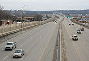
. Highway 52 leaves the river bluffs near Chatfield and enters terrain typical of southern Minnesota. This area is mostly farmland for the rest of the length until the route enters the city of Rochester
. Interstate 90
intersects Highway 52 south of Rochester, and is a major junction. Highway 52 expands to a four-lane freeway north of the junction. The roadway expands further to six-lanes around Rochester, from the junction with U.S. Highway 63
to County Road 14, which is at the northern tip city. U.S. Highway 14 is a major route, and connects Owatonna
to Rochester. North of Rochester, Highway 52 becomes a four-lane expressway through the farmland of Olmsted
and Goodhue
counties. Zumbrota
is bypassed by the highway and the route heads to Dakota County
. In Cannon Falls
, Highway 52 has two traffic lights
in the southern part of town. Mn/DOT plans to remove these and put in an interchange. North of Coates
, Highway 52 enters the edge of the Twin Cities area. The route enters Inver Grove Heights
where it becomes the Lafayette Freeway north of Concord Boulevard. Highway 52 splits with State Highway 55
north of there. Highway 55 heads to Minneapolis, while Highway 52 heads to St. Paul
. Interstate 494
intersects 52 in the northern part of Inver Grove Heights. The St. Paul Downtown Airport
is right off of Highway 52 in St. Paul
. After Highway 52 crosses the Mississippi River
in downtown St. Paul, the route intersects Interstate Highway 94
and follows that route all the way to the North Dakota
state line. U.S. Highway 52 is not signed along the length of its concurrency with Interstate 94 between downtown St. Paul and the North Dakota state line.
 U.S. Highway 52 was extended into the state of Minnesota
in 1934. The road replaced the former routing of old U.S. Highway 55 from the Iowa
state line to the Twin Cities, and the former route of old U.S. Highway 10S
from Minneapolis west to North Dakota
. Interstate 94
replaced most of the routing of Highway 52 west of St. Cloud
, and the routing from St. Cloud
to Minneapolis was replaced by U.S. Highway 10
, U.S. Highway 169
, and Hennepin County Road 81
. Highway 52 was routed along University Avenue
through Minneapolis and St. Paul until about 1995 (In 1986, Highway 52 on University Avenue between I-35W and the St. Paul border was turned over to Hennepin County maintenance and renumbered County 36 / 37, creating a gap in Highway 52 until the 1995 route change).
52 was routed along Robert Street through St. Paul, West St. Paul, and into Inver Grove Heights until 1995; when 52 was moved onto the nearby Lafayette Freeway. The Lafayette Bridge
which takes the highway across the Mississippi River near downtown St. Paul was built in 1968 and is a "fracture critical" structure which is in need of replacement. Construction of the new bridge is planned to begin in 2011.
U.S. Highway 52 was built as an expressway from Rochester
to St. Paul
in the 1960s. The "ROC52" project expanded the section of Highway 52 in Rochester to a 6-lane freeway in 2005–2006. Between Rochester and the Twin Cities, several at-grade intersections have been converted to interchanges since the 1990s.
However, many at-grade intersections remain along this segment of highway. An experimental installation of Cooperative Intersection Collision Avoidance Systems–Stop Sign Assist (CICAS–SSA) was installed at the intersection with Goodhue County Road 9, making use of dynamic message signs to show when it is safe to cross or turn onto the highway. It uses a diagram that looks like a divided highway
sign A full-scale field test began in January 2010, though a previous version had also been tried at the intersection a few years earlier. The study will run through 2012.
Minnesota
Minnesota is a U.S. state located in the Midwestern United States. The twelfth largest state of the U.S., it is the twenty-first most populous, with 5.3 million residents. Minnesota was carved out of the eastern half of the Minnesota Territory and admitted to the Union as the thirty-second state...
at the unincorporated community of Prosper
Prosper, Minnesota
Prosper is an unincorporated community in Canton Township, Fillmore County, Minnesota, United States.The community is located between Harmony, Minnesota and Burr Oak, Iowa on U.S. Route 52...
, north of the town of Burr Oak, Iowa
Burr Oak, Iowa
Burr Oak is a small unincorporated community in Winneshiek County, Iowa, United States, very close to the Minnesota state line. Burr Oak is a census-designated place and the population was 166 in the 2010 census -History:...
. The route is marked north–south in Minnesota along its independent segment from the Iowa state line to downtown St. Paul. Highway 52 is not signed along the length of its concurrency
Concurrency (road)
A concurrency, overlap, or coincidence in a road network is an instance of one physical road bearing two or more different highway, motorway, or other route numbers...
with Interstate 94
Interstate 94 in Minnesota
In the U.S. state of Minnesota, Interstate 94 runs east–west through the central portion of the state. The route connects the cities of Moorhead, Fergus Falls, Alexandria, St...
(I-94) from downtown St. Paul
Saint Paul, Minnesota
Saint Paul is the capital and second-most populous city of the U.S. state of Minnesota. The city lies mostly on the east bank of the Mississippi River in the area surrounding its point of confluence with the Minnesota River, and adjoins Minneapolis, the state's largest city...
to the North Dakota
North Dakota
North Dakota is a state located in the Midwestern region of the United States of America, along the Canadian border. The state is bordered by Canada to the north, Minnesota to the east, South Dakota to the south and Montana to the west. North Dakota is the 19th-largest state by area in the U.S....
state line at Moorhead
Moorhead, Minnesota
Moorhead is a city in Clay County, Minnesota, United States, and the largest city in northwest Minnesota. The population was 38,065 at the 2010 Census. It is the county seat of Clay County....
and Fargo
Fargo, North Dakota
Fargo is the largest city in the U.S. state of North Dakota and the county seat of Cass County. In 2010, its population was 105,549, and it had an estimated metropolitan population of 208,777...
.
Route description
Fillmore County, Minnesota
As of the census of 2000, there were 21,122 people, 8,228 households, and 5,718 families residing in the county. The population density was 24 people per square mile . There were 8,908 housing units at an average density of 10 per square mile...
and heads through the same Driftless Area it ran through in Iowa
Iowa
Iowa is a state located in the Midwestern United States, an area often referred to as the "American Heartland". It derives its name from the Ioway people, one of the many American Indian tribes that occupied the state at the time of European exploration. Iowa was a part of the French colony of New...
. The route heads through Preston
Preston, Minnesota
Preston is a city in Fillmore County, Minnesota, United States. The population was 1,325 at the 2010 census. It is the county seat of Fillmore County. The Root River runs through it, and Mystery Cave State Park is nearby...
and proceeds north to Chatfield
Chatfield, Minnesota
Chatfield is a city in Fillmore and Olmsted counties in the U.S. state of Minnesota. The population was 2,779 at the 2010 census. The city's area is split almost equally between the two counties...
. Highway 52 leaves the river bluffs near Chatfield and enters terrain typical of southern Minnesota. This area is mostly farmland for the rest of the length until the route enters the city of Rochester
Rochester, Minnesota
Rochester is a city in the U.S. state of Minnesota and is the county seat of Olmsted County. Located on both banks of the Zumbro River, The city has a population of 106,769 according to the 2010 United States Census, making it Minnesota's third-largest city and the largest outside of the...
. Interstate 90
Interstate 90 in Minnesota
In the U.S. state of Minnesota, Interstate 90 traverses the southern side of the state, parallel to the Minnesota-Iowa state line. The route connects the cities of Worthington, Albert Lea, and Austin. The cities of Rochester and Winona are also in close proximity to I-90, with Winona about 10...
intersects Highway 52 south of Rochester, and is a major junction. Highway 52 expands to a four-lane freeway north of the junction. The roadway expands further to six-lanes around Rochester, from the junction with U.S. Highway 63
U.S. Route 63 in Minnesota
U.S. Route 63 is a highway in southeastern Minnesota that runs from the Minnesota-Iowa border south of Spring Valley to the Mississippi River at Red Wing. It connects the cities of Spring Valley, Stewartville, Rochester, and Lake City....
to County Road 14, which is at the northern tip city. U.S. Highway 14 is a major route, and connects Owatonna
Owatonna, Minnesota
Owatonna is a city in Steele County, Minnesota, United States. The population was 25,599 at the 2010 census. It is the county seat of Steele County. Owatonna is home to the Steele County Fairgrounds, which hosts the Steele County Free Fair in August....
to Rochester. North of Rochester, Highway 52 becomes a four-lane expressway through the farmland of Olmsted
Olmsted County, Minnesota
As of the census of 2000, there were 124,277 people, 47,807 households, and 32,317 families residing in the county. The population density was 190 people per square mile . There were 49,422 housing units at an average density of 76 per square mile...
and Goodhue
Goodhue County, Minnesota
Goodhue County is a county located in the U.S. state of Minnesota. As of 2010, the population was 46,183. Its county seat is Red Wing. Nearly all of Prairie Island Indian Community is within the county.-History:...
counties. Zumbrota
Zumbrota, Minnesota
As of the census of 2000, there were 2,789 people, 1,141 households, and 741 families residing in the city. The population density was 1,412.6 people per square mile . There were 1,191 housing units at an average density of 603.2 per square mile...
is bypassed by the highway and the route heads to Dakota County
Dakota County, Minnesota
Dakota County is the third most populous county in the U.S. state of Minnesota. The county is bordered by the Minnesota and Mississippi Rivers on the north, and the state of Wisconsin on the east. Dakota County comprises the southeast portion of seven-county Minneapolis-St. Paul, the thirteenth...
. In Cannon Falls
Cannon Falls, Minnesota
As of the census of 2000, there were 3,795 people, 1,550 households, and 996 families residing in the city. The population density was 946.4 people per square mile . There were 1,611 housing units at an average density of 401.8 per square mile...
, Highway 52 has two traffic lights
Traffic light
Traffic lights, which may also be known as stoplights, traffic lamps, traffic signals, signal lights, robots or semaphore, are signalling devices positioned at road intersections, pedestrian crossings and other locations to control competing flows of traffic...
in the southern part of town. Mn/DOT plans to remove these and put in an interchange. North of Coates
Coates, Minnesota
Coates is a city in the U.S. state of Minnesota located west of the Upper Mississippi River on the exurban fringe in central Dakota County. U.S. Highway 52 connects north to Saint Paul while County Road 46 draws east-west to nearby suburban cities. The population was 161 at the 2010 census. It is...
, Highway 52 enters the edge of the Twin Cities area. The route enters Inver Grove Heights
Inver Grove Heights, Minnesota
As of the census of 2000, there were 29,751 people, 11,257 households, and 7,924 families residing in the city. The population density was 1,038.8 people per square mile . There were 11,457 housing units at an average density of 400.1 per square mile...
where it becomes the Lafayette Freeway north of Concord Boulevard. Highway 52 splits with State Highway 55
Minnesota State Highway 55
Minnesota State Highway 55 is a highway in west-central, central, and east-central Minnesota, which runs from the North Dakota state line near Tenney and continues east and southeast to its eastern terminus at its intersection with U.S...
north of there. Highway 55 heads to Minneapolis, while Highway 52 heads to St. Paul
Saint Paul, Minnesota
Saint Paul is the capital and second-most populous city of the U.S. state of Minnesota. The city lies mostly on the east bank of the Mississippi River in the area surrounding its point of confluence with the Minnesota River, and adjoins Minneapolis, the state's largest city...
. Interstate 494
Interstate 494
Interstate 494 is a loop route making up part of a beltway of Interstate 94, circling through the southern and western portions of the Minneapolis – Saint Paul metropolitan area in Minnesota...
intersects 52 in the northern part of Inver Grove Heights. The St. Paul Downtown Airport
St. Paul Downtown Airport
St. Paul Downtown Airport , also known as Holman Field, is an airport just across the Mississippi River from downtown Saint Paul, Minnesota. It is one of several reliever airports in the Twin Cities operated by the Metropolitan Airports Commission...
is right off of Highway 52 in St. Paul
Saint Paul, Minnesota
Saint Paul is the capital and second-most populous city of the U.S. state of Minnesota. The city lies mostly on the east bank of the Mississippi River in the area surrounding its point of confluence with the Minnesota River, and adjoins Minneapolis, the state's largest city...
. After Highway 52 crosses the Mississippi River
Mississippi River
The Mississippi River is the largest river system in North America. Flowing entirely in the United States, this river rises in western Minnesota and meanders slowly southwards for to the Mississippi River Delta at the Gulf of Mexico. With its many tributaries, the Mississippi's watershed drains...
in downtown St. Paul, the route intersects Interstate Highway 94
Interstate 94 in Minnesota
In the U.S. state of Minnesota, Interstate 94 runs east–west through the central portion of the state. The route connects the cities of Moorhead, Fergus Falls, Alexandria, St...
and follows that route all the way to the North Dakota
North Dakota
North Dakota is a state located in the Midwestern region of the United States of America, along the Canadian border. The state is bordered by Canada to the north, Minnesota to the east, South Dakota to the south and Montana to the west. North Dakota is the 19th-largest state by area in the U.S....
state line. U.S. Highway 52 is not signed along the length of its concurrency with Interstate 94 between downtown St. Paul and the North Dakota state line.
History
Minnesota
Minnesota is a U.S. state located in the Midwestern United States. The twelfth largest state of the U.S., it is the twenty-first most populous, with 5.3 million residents. Minnesota was carved out of the eastern half of the Minnesota Territory and admitted to the Union as the thirty-second state...
in 1934. The road replaced the former routing of old U.S. Highway 55 from the Iowa
Iowa
Iowa is a state located in the Midwestern United States, an area often referred to as the "American Heartland". It derives its name from the Ioway people, one of the many American Indian tribes that occupied the state at the time of European exploration. Iowa was a part of the French colony of New...
state line to the Twin Cities, and the former route of old U.S. Highway 10S
U.S. Route 10
U.S. Route 10 is an east–west United States highway formed in 1926. Though it never became the cross-country highway suggested by the "0" as the last digit of its route number, U.S...
from Minneapolis west to North Dakota
North Dakota
North Dakota is a state located in the Midwestern region of the United States of America, along the Canadian border. The state is bordered by Canada to the north, Minnesota to the east, South Dakota to the south and Montana to the west. North Dakota is the 19th-largest state by area in the U.S....
. Interstate 94
Interstate 94 in Minnesota
In the U.S. state of Minnesota, Interstate 94 runs east–west through the central portion of the state. The route connects the cities of Moorhead, Fergus Falls, Alexandria, St...
replaced most of the routing of Highway 52 west of St. Cloud
St. Cloud, Minnesota
St. Cloud is a city in the U.S. state of Minnesota and the largest population center in the state's central region. The population was 65,842 at the 2010 census. It is the county seat of Stearns County...
, and the routing from St. Cloud
St. Cloud, Minnesota
St. Cloud is a city in the U.S. state of Minnesota and the largest population center in the state's central region. The population was 65,842 at the 2010 census. It is the county seat of Stearns County...
to Minneapolis was replaced by U.S. Highway 10
U.S. Route 10 in Minnesota
U.S. Route 10 is a major divided highway for almost all of its length in the U.S. state of Minnesota. The route runs through the central portion of the state, following closely the alignment of the former Northern Pacific Railway and connects the cities of Moorhead, Detroit Lakes, Wadena, Little...
, U.S. Highway 169
U.S. Route 169 in Minnesota
U.S. Route 169 is a major north–south highway in the U.S. state of Minnesota, connecting the Minnesota River valley with the Twin Cities and the Iron Range. Much of the route is built to expressway or freeway standards.-Route description:U.S...
, and Hennepin County Road 81
County Road 81 (Hennepin County, Minnesota)
County State-Aid Highway 81 or County Road 81 is a county highway in Hennepin County, Minnesota, which runs from its junction with Interstate 94 , CR 66, and CR 152 in the city of Minneapolis, and continues northwest to its terminus at Main Street in suburban...
. Highway 52 was routed along University Avenue
University Avenue (Minneapolis-St. Paul)
University Avenue in the Minneapolis–St. Paul region of Minnesota begins near the Minnesota State Capitol in Saint Paul and extends westward into neighboring Minneapolis, where it passes the University of Minnesota, and then turns north to pass through several suburbs before ending in Blaine,...
through Minneapolis and St. Paul until about 1995 (In 1986, Highway 52 on University Avenue between I-35W and the St. Paul border was turned over to Hennepin County maintenance and renumbered County 36 / 37, creating a gap in Highway 52 until the 1995 route change).
52 was routed along Robert Street through St. Paul, West St. Paul, and into Inver Grove Heights until 1995; when 52 was moved onto the nearby Lafayette Freeway. The Lafayette Bridge
Lafayette Bridge
The Lafayette Bridge is a bridge carrying U.S. Route 52 across the Mississippi River in downtown St. Paul. At this point, US 52 is on the Lafayette Freeway. The bridge spans across railroad yards north of the Mississippi, the river itself, and industrial areas south of the Mississippi...
which takes the highway across the Mississippi River near downtown St. Paul was built in 1968 and is a "fracture critical" structure which is in need of replacement. Construction of the new bridge is planned to begin in 2011.
U.S. Highway 52 was built as an expressway from Rochester
Rochester, Minnesota
Rochester is a city in the U.S. state of Minnesota and is the county seat of Olmsted County. Located on both banks of the Zumbro River, The city has a population of 106,769 according to the 2010 United States Census, making it Minnesota's third-largest city and the largest outside of the...
to St. Paul
Saint Paul, Minnesota
Saint Paul is the capital and second-most populous city of the U.S. state of Minnesota. The city lies mostly on the east bank of the Mississippi River in the area surrounding its point of confluence with the Minnesota River, and adjoins Minneapolis, the state's largest city...
in the 1960s. The "ROC52" project expanded the section of Highway 52 in Rochester to a 6-lane freeway in 2005–2006. Between Rochester and the Twin Cities, several at-grade intersections have been converted to interchanges since the 1990s.
However, many at-grade intersections remain along this segment of highway. An experimental installation of Cooperative Intersection Collision Avoidance Systems–Stop Sign Assist (CICAS–SSA) was installed at the intersection with Goodhue County Road 9, making use of dynamic message signs to show when it is safe to cross or turn onto the highway. It uses a diagram that looks like a divided highway
Divided Highway
Divided Highway is a compilation album by American rock band The Doobie Brothers, released in 2003. . All tracks are taken from the albums Cycles and Brotherhood .-Track listing:...
sign A full-scale field test began in January 2010, though a previous version had also been tried at the intersection a few years earlier. The study will run through 2012.
Major intersections
| County | Location | Mile | Destinations | Notes |
|---|---|---|---|---|
| Fillmore Fillmore County, Minnesota As of the census of 2000, there were 21,122 people, 8,228 households, and 5,718 families residing in the county. The population density was 24 people per square mile . There were 8,908 housing units at an average density of 10 per square mile... |
Prosper Prosper, Minnesota Prosper is an unincorporated community in Canton Township, Fillmore County, Minnesota, United States.The community is located between Harmony, Minnesota and Burr Oak, Iowa on U.S. Route 52... |
0 | State line | |
| 1 | ||||
| Harmony Harmony, Minnesota Harmony is a city in Fillmore County, Minnesota, United States. The population was 1,020 at the 2010 census. The town bills itself as the "Biggest Little Town in Southern Minnesota" and features the largest Amish community in the state.-Geography:... |
9 | |||
| Preston Preston, Minnesota Preston is a city in Fillmore County, Minnesota, United States. The population was 1,325 at the 2010 census. It is the county seat of Fillmore County. The Root River runs through it, and Mystery Cave State Park is nearby... |
17 | South end of MN 16 overlap. | ||
| 20 | North end of MN 16 overlap | |||
| Fountain Fountain, Minnesota Fountain is a city in Fillmore County, Minnesota, United States. The population was 410 at the 2010 census. Fountain is the western terminus of the Root River segment of the Blufflands State Trail.-Geography:... |
24 | |||
| Chatfield Chatfield, Minnesota Chatfield is a city in Fillmore and Olmsted counties in the U.S. state of Minnesota. The population was 2,779 at the 2010 census. The city's area is split almost equally between the two counties... |
34 | South end of MN 30 overlap. MN 74 begins. | ||
| Olmsted | 34 | North end of MN 30 overlap. | ||
| Marion | 46 | – La Crosse | ||
| 46 | Begin freeway after interchange. | |||
| 47 | ||||
| Rochester | 50 | |||
| 51 | To I-90 West. 6-lane freeway begins. | |||
| 53 | Apache Mall, Olmsted County Fairgrounds | |||
| 54 | No access northbound | |||
| 54 | No access northbound | |||
| 55 | 6th Street SW | No access southbound | ||
| 55 | 2nd Street SW | Mayo Clinic Mayo Clinic Mayo Clinic is a not-for-profit medical practice and medical research group specializing in treating difficult patients . Patients are referred to Mayo Clinic from across the U.S. and the world, and it is known for innovative and effective treatments. Mayo Clinic is known for being at the top of... , St. Marys Hospital |
||
| 56 | Civic Center Dr NW | |||
| 56 | Partial cloverleaf | |||
| 56 | 19th Street NW, Elton Hills Dr NW | Single Point Urban Interchange | ||
| 58 | ||||
| 59 | ||||
| 61 | 6-lane freeways ends, yet it remains a 4-lane freeway. Partial Cloverleaf | |||
| Oronoco | 65 | |||
| Goodhue | Pine Island | 70 | ||
| Zumbrota | 75 | |||
| 77 | ||||
| 78 | ||||
| Hader Hader, Minnesota Hader is an unincorporated community located along U.S. Route 52 in Goodhue County, Minnesota, United States.-History:When Hader was founded by Otis F. Smith in 1857, it was built in order to be the county seat. However, these plans failed; the plat was not fulfilled, and few buildings were... |
86 | |||
| Wastedo | 89 | |||
| 91 | ||||
| 91 | ||||
| Cannon Falls | 96.5 | |||
| 96.6 | ||||
| 98 | ||||
| Dakota Dakota County, Minnesota Dakota County is the third most populous county in the U.S. state of Minnesota. The county is bordered by the Minnesota and Mississippi Rivers on the north, and the state of Wisconsin on the east. Dakota County comprises the southeast portion of seven-county Minneapolis-St. Paul, the thirteenth... |
Hampton | 105 | ||
| Coates | 113 | |||
| Rosemount | 115 | |||
| 117 | Intersection northbound and Exit southbound | |||
| 118 | 117th St | |||
| Inver Grove Heights | 120 | |||
| 121 | Northbound exit and southbound entrance | |||
| 122 | ||||
| 123 | ||||
| 124 | Upper 55th Street East | |||
| 125 | ||||
| South St. Paul | 126 | Southview Boulevard, Mendota Road | ||
| South St. Paul/West St. Paul | 127 | Wentworth Avenue, Thompson Avenue | ||
| 128 | Butler Avenue | |||
| Ramsey | St. Paul | 129 | ||
| 130 | Eaton Street | Southbound exit and northbound entrance | ||
| 130 | Plato Boulevard, Fillmore Avenue | |||
| 131 | Northbound exit and southbound entrance | |||
| 131 | Northbound exit and southbound entrance | |||
| US 52 continues unsigned, overlapping Interstate 94 Interstate 94 in Minnesota In the U.S. state of Minnesota, Interstate 94 runs east–west through the central portion of the state. The route connects the cities of Moorhead, Fergus Falls, Alexandria, St... . |
||||