

Minnesota State Highway 55
Encyclopedia
Minnesota State Highway 55 is a highway
in west-central, central, and east-central Minnesota
, which runs from the North Dakota state line near Tenney
and continues east and southeast to its eastern terminus at its intersection
with U.S. Highway 61
in Hastings
.
This route, signed east–west, runs roughly diagonally across the central part of Minnesota.
Highway 55 is 221 miles (355.7 km) in length.
, Glenwood
, Paynesville
, Annandale
, Buffalo
, Plymouth
, Minneapolis, Mendota Heights
, and Hastings
.
Highway 55 begins at the Bois de Sioux River
, at the Minnesota — North Dakota state line near Tenney
. North Dakota Highway 11 is its counterpoint upon crossing the state line. Highway 55 continues east to Tenney, Nashua
, and Wendell
. The route has a junction
with U.S. Highway 59
before entering the city of Elbow Lake
. Highways 55 and 59 run concurrently
for 11 miles until reaching Barrett
.
Highway 55 then continues independently again to Hoffman
, Kensington
, Farwell
, and Lowry
before reaching the city of Glenwood
. At Glenwood, Highway 55 has an intersection
with State Highway 29
and an interchange
with State Highway 28
.
The route continues southeast to Sedan
and Brooten
before reaching its junction
with U.S. Highway 71
in Belgrade
. Highway 55 passes through Regal
before reaching its junction
with State Highways 4
and 23
at the city of Paynesville
.
Highway 55 continues east to Eden Valley
and Watkins
before reaching its junction
with State Highway 15
at Kimball
.
The route has a junction
with State Highway 24
in Annandale
. Highway 55 continues to Maple Lake
and then Buffalo
, where it has a junction
with State Highway 25
.
Highway 55 enters the Twin Cities area at Rockford
and Greenfield
, continuing east to Medina
and Plymouth
. Highway 55 has a junction
with I-494
in Plymouth. Highway 55 continues east and has a junction with U.S. Highway 169
at the Plymouth
/ Golden Valley
boundary line. Highway 55 continues through Golden Valley to its junction with State Highway 100
. The route then continues east and enters the city of Minneapolis.
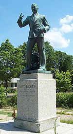
The western portion of the highway coming into downtown Minneapolis is known as Olson Memorial Highway, named for Floyd B. Olson
, a popular Minnesota governor of Norwegian ancestry. The part of Highway 55 southeast of downtown is known as Hiawatha Avenue. A light rail
corridor, the Hiawatha Line
, runs parallel to the highway for much of the Hiawatha Avenue stretch.
 In July 2005, the section of Highway 55 that runs through downtown Minneapolis was turned back to local maintenance. To fill the gap, Highway 55 was rerouted along Interstate 94
. Westbound, 55 now exits just before downtown at the westbound I-94
exit, and leaves the concurrency
at the exit for the Olson Highway, marked with the Highway 55 shield. Eastbound, 55 leaves the Olson Highway at the interchange
for I-94
eastbound, and leaves the freeway at the exit for Hiawatha Avenue, which is also marked with the Highway 55 shield.
There has been some controversy with expansion of the highway. An area known as Camp Coldwater
, considered by some as the "birthplace of Minnesota," was dug up during some construction. Highway 55 has a junction
with State Highway 62
at this point.
Fort Snelling State Park
is located near the junction
of Highway 55 and State Highway 5
. The park entrance is located on Highway 5 at Post Road.
Highway 55 crosses the Minnesota River
via the Mendota Bridge, which was the longest continuous bridge made of poured concrete
when it was completed in 1926. It is 4119 feet (1,255.5 m) in length.
 The route enters Mendota Heights
and has a junction
with State Highways 13
and 110
.
Highway 55 continues southeast through Eagan
, joining briefly with State Highway 149
. The route then has a junction
with State Highway 3
in Inver Grove Heights
. Highway 55 then runs concurrent
with U.S. Highway 52
through Inver Grove Heights and into Rosemount
. At Rosemount, Highway 55 leaves U.S. 52
. Highway 55 continues independently again to its eastern terminus at its intersection
with U.S. Highway 61
in the city of Hastings
.
In late December 2006, someone added a 7 feet (2.1 m) painting of Pac-Man
near one of the anti-tailgating
dots on the road. This is located on the portion of Highway 55 between Buffalo
and Rockford
, traveling east of Buffalo.http://gamepolitics.com/2006/12/22/minnesota-highway-officials-puzzled-by-pac-man/
|colspan=2 align='center'|Bois de Sioux River
|0.000
|
|
Highway
A highway is any public road. In American English, the term is common and almost always designates major roads. In British English, the term designates any road open to the public. Any interconnected set of highways can be variously referred to as a "highway system", a "highway network", or a...
in west-central, central, and east-central Minnesota
Minnesota
Minnesota is a U.S. state located in the Midwestern United States. The twelfth largest state of the U.S., it is the twenty-first most populous, with 5.3 million residents. Minnesota was carved out of the eastern half of the Minnesota Territory and admitted to the Union as the thirty-second state...
, which runs from the North Dakota state line near Tenney
Tenney, Minnesota
Tenney is a former city, now an unincorporated community, in section 28 of Campbell Township, Wilkin County, Minnesota, United States. A post office was established there in 1887, and Tenney was incorporated as a city on November 30, 1901. The population was five at the 2010 census, making the...
and continues east and southeast to its eastern terminus at its intersection
Intersection (road)
An intersection is a road junction where two or more roads either meet or cross at grade . An intersection may be 3-way - a T junction or fork, 4-way - a crossroads, or 5-way or more...
with U.S. Highway 61
U.S. Route 61 in Minnesota
U.S. Highway 61 is a highway in southeast and east-central Minnesota, which runs from the River Bridge over the Mississippi River at La Crescent and continues north to its northern terminus at its junction with Interstate 35 at the city of Wyoming....
in Hastings
Hastings, Minnesota
Hastings is a city in Dakota counties in the U.S. state of Minnesota, near the confluence of the Mississippi and St. Croix Rivers. The population was 22,172 at the 2010 census. It is the county seat of Dakota County. The bulk of Hastings is in Dakota County; only a small part of the city extends...
.
This route, signed east–west, runs roughly diagonally across the central part of Minnesota.
Highway 55 is 221 miles (355.7 km) in length.
Route description
Highway 55 serves as a northwest–southeast route between Elbow LakeElbow Lake, Grant County, Minnesota
Elbow Lake is a city in, and the county seat of, Grant County, Minnesota, United States. The population was 1,176 at the 2010 census.-Geography:...
, Glenwood
Glenwood, Minnesota
As of the census of 2000, there were 2,594 people, 1,131 households, and 629 families residing in the city. The population density was 466.0 people per square mile . There were 1,202 housing units at an average density of 215.9 per square mile...
, Paynesville
Paynesville, Minnesota
As of the census of 2000, there were 2,267 people, 934 households, and 594 families residing in the city. The population density was 1,715.2 people per square mile . There were 984 housing units at an average density of 744.5 per square mile...
, Annandale
Annandale, Minnesota
As of the census of 2000, there were 2,684 people, 1,098 households, and 698 families residing in the city. The population density was 990.3 people per square mile . There were 1,163 housing units at an average density of 429.1 per square mile...
, Buffalo
Buffalo, Minnesota
As of the census of 2008, there were 18,141 people, 6,612 households, and 6,313 families residing in the city. The population density was 1,675.8 people per square mile . There were 3,871 housing units at an average density of 642.5 per square mile...
, Plymouth
Plymouth, Minnesota
As of the census of 2000, there were 65,894 people, 24,820 households, and 17,647 families residing in the city. The population density was 2,002.0 persons per square mile . There were 25,258 housing units at an average density of 767.4 per square mile...
, Minneapolis, Mendota Heights
Mendota Heights, Minnesota
At the 2000 census, there were 11,434 people, 4,178 households and 3,237 families residing in the town. The population density was 1,222.2 per square mile . There were 4,252 housing units at an average density of 454.5 per square mile...
, and Hastings
Hastings, Minnesota
Hastings is a city in Dakota counties in the U.S. state of Minnesota, near the confluence of the Mississippi and St. Croix Rivers. The population was 22,172 at the 2010 census. It is the county seat of Dakota County. The bulk of Hastings is in Dakota County; only a small part of the city extends...
.
Highway 55 begins at the Bois de Sioux River
Bois de Sioux River
The Bois de Sioux River drains Lake Traverse, the southernmost body of water in the Hudson Bay watershed of North America. It is a tributary of the Red River of the North and defines part of the western border of the U.S. state of Minnesota, and the eastern borders of North Dakota and South Dakota...
, at the Minnesota — North Dakota state line near Tenney
Tenney, Minnesota
Tenney is a former city, now an unincorporated community, in section 28 of Campbell Township, Wilkin County, Minnesota, United States. A post office was established there in 1887, and Tenney was incorporated as a city on November 30, 1901. The population was five at the 2010 census, making the...
. North Dakota Highway 11 is its counterpoint upon crossing the state line. Highway 55 continues east to Tenney, Nashua
Nashua, Minnesota
Nashua is a city in Wilkin County, Minnesota, United States. The population was 68 at the 2010 census. It is part of the Wahpeton, ND–MN Micropolitan Statistical Area.-Geography:...
, and Wendell
Wendell, Minnesota
Wendell is a city in Grant County, Minnesota, United States. The population was 167 at the 2010 census.-Geography:According to the United States Census Bureau, the city has a total area of , all of it land....
. The route has a junction
Junction (traffic)
A junction, when discussed in the context of transport, is a location where traffic can change between different routes, directions, or sometimes modes, of travel.-Historical significance:...
with U.S. Highway 59
U.S. Route 59
U.S. Route 59 is a north–south United States highway . A latecomer to the U.S. numbered route system, U.S. 59 is now a border-to-border route, Part of NAFTA Corridor Highway System. It parallels U.S. Route 75 for nearly its entire route, never much more than away, until it veers southwest...
before entering the city of Elbow Lake
Elbow Lake, Grant County, Minnesota
Elbow Lake is a city in, and the county seat of, Grant County, Minnesota, United States. The population was 1,176 at the 2010 census.-Geography:...
. Highways 55 and 59 run concurrently
Concurrency (road)
A concurrency, overlap, or coincidence in a road network is an instance of one physical road bearing two or more different highway, motorway, or other route numbers...
for 11 miles until reaching Barrett
Barrett, Minnesota
Barrett is a city in Grant County, Minnesota, United States. The population was 415 at the 2010 census. Troy Johnson is the mayor.-Geography:...
.
Highway 55 then continues independently again to Hoffman
Hoffman, Minnesota
As of the census of 2000, there were 672 people, 274 households, and 164 families residing in the city. The population density was 319.9 people per square mile . There were 307 housing units at an average density of 146.2 per square mile . The racial makeup of the city was 98.36% White, 0.45%...
, Kensington
Kensington, Minnesota
Kensington is a city in Douglas County, Minnesota, United States. The population was 292 at the 2010 census. The city is notable in Minnesota history for being the place where the famous, if questionable, Kensington Runestone was first displayed. The stone tablet may indicate that Scandinavians...
, Farwell
Farwell, Minnesota
Farwell is a city in Pope County, Minnesota, United States. The population was 51 at the 2010 census.-Geography:According to the United States Census Bureau, the city has a total area of , all of it land....
, and Lowry
Lowry, Minnesota
Lowry is a city in Pope County, Minnesota, United States. The population was 299 at the 2010 census.-Geography:According to the United States Census Bureau, the city has a total area of , all of it land....
before reaching the city of Glenwood
Glenwood, Minnesota
As of the census of 2000, there were 2,594 people, 1,131 households, and 629 families residing in the city. The population density was 466.0 people per square mile . There were 1,202 housing units at an average density of 215.9 per square mile...
. At Glenwood, Highway 55 has an intersection
Intersection (road)
An intersection is a road junction where two or more roads either meet or cross at grade . An intersection may be 3-way - a T junction or fork, 4-way - a crossroads, or 5-way or more...
with State Highway 29
Minnesota State Highway 29
Minnesota State Highway 29 is a highway in west-central Minnesota, which runs from its junction with U.S. Highways 59 and 212 in Montevideo and continues north to its northern terminus at its intersection with U.S...
and an interchange
Interchange (road)
In the field of road transport, an interchange is a road junction that typically uses grade separation, and one or more ramps, to permit traffic on at least one highway to pass through the junction without directly crossing any other traffic stream. It differs from a standard intersection, at which...
with State Highway 28
Minnesota State Highway 28
Minnesota State Highway 28 is a highway in west-central and central Minnesota, which runs from South Dakota Highway 10 at the South Dakota state line near Browns Valley and continues east to its eastern terminus at its intersection with the former route of U.S...
.
The route continues southeast to Sedan
Sedan, Minnesota
Sedan is a city in Pope County, Minnesota, United States. The population was 45 at the 2010 census.-Geography:According to the United States Census Bureau, the city has a total area of , all of it land....
and Brooten
Brooten, Minnesota
As of the census of 2000, there were 649 people, 278 households, and 167 families residing in the city. The population density was 446.7 people per square mile . There were 338 housing units at an average density of 232.7 per square mile...
before reaching its junction
Junction (traffic)
A junction, when discussed in the context of transport, is a location where traffic can change between different routes, directions, or sometimes modes, of travel.-Historical significance:...
with U.S. Highway 71
U.S. Route 71
U.S. Route 71 is a north–south United States highway. This original 1926 route has remained largely unchanged by encroaching Interstate highways. Currently, the highway's northern terminus is in International Falls, Minnesota at the Canadian border, at the southern end of the Fort...
in Belgrade
Belgrade, Minnesota
Belgrade is a town in Stearns County, Minnesota, United States. The population was 740 at the 2010 census. It is part of the St. Cloud Metropolitan Statistical Area.-Geography:...
. Highway 55 passes through Regal
Regal, Minnesota
Regal is a city in Kandiyohi County, Minnesota, United States, along the North Fork of the Crow River. The population was 34 at the 2010 census.-Geography:According to the United States Census Bureau, the city has a total land area of ....
before reaching its junction
Junction (traffic)
A junction, when discussed in the context of transport, is a location where traffic can change between different routes, directions, or sometimes modes, of travel.-Historical significance:...
with State Highways 4
Minnesota State Highway 4
Minnesota State Highway 4 is a highway in southwest and west-central Minnesota, which runs from Iowa Highway 4 at the Iowa state line , and continues north to its northern terminus at its interchange with Interstate Highway 94 near Sauk Centre and Melrose.Highway 4 is in length.-Route...
and 23
Minnesota State Highway 23
Minnesota State Highway 23 is a state highway that stretches from southwest to northeast Minnesota. At in length, it is the second longest state route in Minnesota, after MN 1....
at the city of Paynesville
Paynesville, Minnesota
As of the census of 2000, there were 2,267 people, 934 households, and 594 families residing in the city. The population density was 1,715.2 people per square mile . There were 984 housing units at an average density of 744.5 per square mile...
.
Highway 55 continues east to Eden Valley
Eden Valley, Minnesota
Eden Valley is a city in Meeker and Stearns counties in the U.S. state of Minnesota. The population was 1,042 at the 2010 census. Most of Eden Valley is located in Meeker County.The Stearns County portion of Eden Valley is part of the St...
and Watkins
Watkins, Minnesota
Watkins is a city in Meeker County, Minnesota, United States. The population was 962 at the 2010 census.-Geography:According to the United States Census Bureau, the city has a total area of , all of it land....
before reaching its junction
Junction (traffic)
A junction, when discussed in the context of transport, is a location where traffic can change between different routes, directions, or sometimes modes, of travel.-Historical significance:...
with State Highway 15
Minnesota State Highway 15
Minnesota State Highway 15 is a highway in south-central and central Minnesota, which runs from Iowa Highway 15 at the Iowa state line and continues north to its northern terminus at its interchange with U.S. Highway 10 outside of Sartell and Sauk Rapids, north of St...
at Kimball
Kimball, Minnesota
As of the census of 2000, there were 635 people, 262 households, and 165 families residing in the city. The population density was 459.0 people per square mile . There were 280 housing units at an average density of 202.4 per square mile...
.
The route has a junction
Junction (traffic)
A junction, when discussed in the context of transport, is a location where traffic can change between different routes, directions, or sometimes modes, of travel.-Historical significance:...
with State Highway 24
Minnesota State Highway 24
Minnesota State Highway 24 is a highway in central Minnesota, which runs from its intersection with U.S. Highway 12 and State Highway 22 in Litchfield and continues northeast to its intersection with U.S...
in Annandale
Annandale, Minnesota
As of the census of 2000, there were 2,684 people, 1,098 households, and 698 families residing in the city. The population density was 990.3 people per square mile . There were 1,163 housing units at an average density of 429.1 per square mile...
. Highway 55 continues to Maple Lake
Maple Lake, Minnesota
Maple Lake is a city in Wright County, Minnesota, United States. The population was 2,059 at the 2010 census.Minnesota State Highway 55 serves as a main route in the city.-History:...
and then Buffalo
Buffalo, Minnesota
As of the census of 2008, there were 18,141 people, 6,612 households, and 6,313 families residing in the city. The population density was 1,675.8 people per square mile . There were 3,871 housing units at an average density of 642.5 per square mile...
, where it has a junction
Junction (traffic)
A junction, when discussed in the context of transport, is a location where traffic can change between different routes, directions, or sometimes modes, of travel.-Historical significance:...
with State Highway 25
Minnesota State Highway 25
Minnesota State Highway 25 is a highway in Minnesota, which runs from its interchange with U.S. Highway 169 in Belle Plaine and continues north to its northern terminus at its intersection with State Highway 210 in Brainerd.The route is in length....
.
Highway 55 enters the Twin Cities area at Rockford
Rockford, Minnesota
As of the census of 2000, there were 3,484 people, 1,296 households, and 929 families residing in the city. The population density was 2,021.2 people per square mile . There were 1,333 housing units at an average density of 773.3 per square mile...
and Greenfield
Greenfield, Minnesota
Greenfield is a city in Hennepin County, Minnesota, United States, along the Crow River. The population was 2,777 at the 2010 census.-Geography:...
, continuing east to Medina
Medina, Minnesota
Medina is a city in Hennepin County, Minnesota, United States. The population was 4,892 at the 2010 census.-Geography:According to the United States Census Bureau, the city has a total area of , of which, of it is land and of it is water...
and Plymouth
Plymouth, Minnesota
As of the census of 2000, there were 65,894 people, 24,820 households, and 17,647 families residing in the city. The population density was 2,002.0 persons per square mile . There were 25,258 housing units at an average density of 767.4 per square mile...
. Highway 55 has a junction
Junction (traffic)
A junction, when discussed in the context of transport, is a location where traffic can change between different routes, directions, or sometimes modes, of travel.-Historical significance:...
with I-494
Interstate 494
Interstate 494 is a loop route making up part of a beltway of Interstate 94, circling through the southern and western portions of the Minneapolis – Saint Paul metropolitan area in Minnesota...
in Plymouth. Highway 55 continues east and has a junction with U.S. Highway 169
U.S. Route 169 in Minnesota
U.S. Route 169 is a major north–south highway in the U.S. state of Minnesota, connecting the Minnesota River valley with the Twin Cities and the Iron Range. Much of the route is built to expressway or freeway standards.-Route description:U.S...
at the Plymouth
Plymouth, Minnesota
As of the census of 2000, there were 65,894 people, 24,820 households, and 17,647 families residing in the city. The population density was 2,002.0 persons per square mile . There were 25,258 housing units at an average density of 767.4 per square mile...
/ Golden Valley
Golden Valley, Minnesota
As of the census of 2000, there were 20,281 people, 8,449 households, and 5,508 families residing in the city. The population density was 1,982.3 people per square mile . There were 8,589 housing units at an average density of 839.5 per square mile...
boundary line. Highway 55 continues through Golden Valley to its junction with State Highway 100
Minnesota State Highway 100
Minnesota State Highway 100 is a state highway in the Twin Cities region of Minnesota, which runs from its interchange with Interstate 494 in Bloomington and continues north to its northern terminus at its interchange with I-694 in Brooklyn Center...
. The route then continues east and enters the city of Minneapolis.
The western portion of the highway coming into downtown Minneapolis is known as Olson Memorial Highway, named for Floyd B. Olson
Floyd B. Olson
Floyd Bjørnstjerne Olson was an American politician. He served as the 22nd Governor of Minnesota from January 6, 1931 to August 22, 1936. He died in office from stomach cancer. He was a member of the Minnesota Farmer-Labor Party, and was the first member of the Farmer-Labor Party to win the...
, a popular Minnesota governor of Norwegian ancestry. The part of Highway 55 southeast of downtown is known as Hiawatha Avenue. A light rail
Light rail
Light rail or light rail transit is a form of urban rail public transportation that generally has a lower capacity and lower speed than heavy rail and metro systems, but higher capacity and higher speed than traditional street-running tram systems...
corridor, the Hiawatha Line
Hiawatha Line
The Hiawatha Line is a light rail corridor in Hennepin County, Minnesota that extends from downtown Minneapolis to the southern suburb of Bloomington. It was formerly known as the Hiawatha Line named after Hiawatha Avenue. Major connections on the line include the Minneapolis-St...
, runs parallel to the highway for much of the Hiawatha Avenue stretch.
Interstate 94 in Minnesota
In the U.S. state of Minnesota, Interstate 94 runs east–west through the central portion of the state. The route connects the cities of Moorhead, Fergus Falls, Alexandria, St...
. Westbound, 55 now exits just before downtown at the westbound I-94
Interstate 94 in Minnesota
In the U.S. state of Minnesota, Interstate 94 runs east–west through the central portion of the state. The route connects the cities of Moorhead, Fergus Falls, Alexandria, St...
exit, and leaves the concurrency
Concurrency (road)
A concurrency, overlap, or coincidence in a road network is an instance of one physical road bearing two or more different highway, motorway, or other route numbers...
at the exit for the Olson Highway, marked with the Highway 55 shield. Eastbound, 55 leaves the Olson Highway at the interchange
Interchange (road)
In the field of road transport, an interchange is a road junction that typically uses grade separation, and one or more ramps, to permit traffic on at least one highway to pass through the junction without directly crossing any other traffic stream. It differs from a standard intersection, at which...
for I-94
Interstate 94 in Minnesota
In the U.S. state of Minnesota, Interstate 94 runs east–west through the central portion of the state. The route connects the cities of Moorhead, Fergus Falls, Alexandria, St...
eastbound, and leaves the freeway at the exit for Hiawatha Avenue, which is also marked with the Highway 55 shield.
There has been some controversy with expansion of the highway. An area known as Camp Coldwater
Camp Coldwater
Camp Coldwater is an area of several springs that are important to Native Americans, as well as an early European settlement in the state of Minnesota, USA. Camp Coldwater is located adjacent to the Mississippi River in south Minneapolis, directly south of Minnehaha Park.The camp was explored by...
, considered by some as the "birthplace of Minnesota," was dug up during some construction. Highway 55 has a junction
Junction (traffic)
A junction, when discussed in the context of transport, is a location where traffic can change between different routes, directions, or sometimes modes, of travel.-Historical significance:...
with State Highway 62
Minnesota State Highway 62 (east)
Minnesota State Highway 62 is a highway in the Twin Cities region of Minnesota. The route was part of Hennepin County Road 62 until 1988, when a portion of the route was inherited by the state. The western terminus of the route is at Interstate Highway 494 in Eden Prairie, where the roadway...
at this point.
Fort Snelling State Park
Fort Snelling State Park
Fort Snelling State Park is a state park of Minnesota, USA, at the confluence of the Mississippi and Minnesota rivers. Its most notable feature is the historic Fort Snelling, which dates from 1820. The fort itself is operated by the Minnesota Historical Society and requires a separate entrance fee...
is located near the junction
Junction (traffic)
A junction, when discussed in the context of transport, is a location where traffic can change between different routes, directions, or sometimes modes, of travel.-Historical significance:...
of Highway 55 and State Highway 5
Minnesota State Highway 5
Minnesota State Highway 5 is a highway in Minnesota, which runs from its intersection with State Highways 19 and 22 in Gaylord and continues east and northeast to its eastern terminus at its interchange with State Highway 36 and Washington County Road 5 in Stillwater...
. The park entrance is located on Highway 5 at Post Road.
Highway 55 crosses the Minnesota River
Minnesota River
The Minnesota River is a tributary of the Mississippi River, approximately 332 miles long, in the U.S. state of Minnesota. It drains a watershed of nearly , in Minnesota and about in South Dakota and Iowa....
via the Mendota Bridge, which was the longest continuous bridge made of poured concrete
Concrete
Concrete is a composite construction material, composed of cement and other cementitious materials such as fly ash and slag cement, aggregate , water and chemical admixtures.The word concrete comes from the Latin word...
when it was completed in 1926. It is 4119 feet (1,255.5 m) in length.
Mendota Heights, Minnesota
At the 2000 census, there were 11,434 people, 4,178 households and 3,237 families residing in the town. The population density was 1,222.2 per square mile . There were 4,252 housing units at an average density of 454.5 per square mile...
and has a junction
Junction (traffic)
A junction, when discussed in the context of transport, is a location where traffic can change between different routes, directions, or sometimes modes, of travel.-Historical significance:...
with State Highways 13
Minnesota State Highway 13
Minnesota State Highway 13 is a highway in Minnesota that runs from its intersection with U.S. Highway 65 in Albert Lea to its northern terminus at its intersection with State Highway 149 at the West St...
and 110
Minnesota State Highway 110
Minnesota State Highway 110 is a short connector highway in Minnesota, which runs from its interchange with State Highway 55 in Mendota Heights and continues east to its eastern terminus at its interchange with Interstate 494 in Inver Grove Heights, south of downtown Saint Paul.Highway 110 is in...
.
Highway 55 continues southeast through Eagan
Eagan, Minnesota
Eagan is a city south of Saint Paul in Dakota County in the U.S. state of Minnesota. The city lies on the south bank of the Minnesota River, upstream from the confluence with the Mississippi River. Eagan and nearby suburbs form the southern portion of Minneapolis-St. Paul, the fifteenth largest...
, joining briefly with State Highway 149
Minnesota State Highway 149
Minnesota State Highway 149 is a highway in Minnesota that runs from its intersection with State Highway 3 in Inver Grove Heights to its northern terminus at its intersection with State Highway 5 in Saint Paul. The route is in length....
. The route then has a junction
Junction (traffic)
A junction, when discussed in the context of transport, is a location where traffic can change between different routes, directions, or sometimes modes, of travel.-Historical significance:...
with State Highway 3
Minnesota State Highway 3
Minnesota State Highway 3 is a state highway in Minnesota, which runs from its intersection with MN 21 in Faribault and continues north to its northern terminus at an interchange with MN 110 in Inver Grove Heights...
in Inver Grove Heights
Inver Grove Heights, Minnesota
As of the census of 2000, there were 29,751 people, 11,257 households, and 7,924 families residing in the city. The population density was 1,038.8 people per square mile . There were 11,457 housing units at an average density of 400.1 per square mile...
. Highway 55 then runs concurrent
Concurrency (road)
A concurrency, overlap, or coincidence in a road network is an instance of one physical road bearing two or more different highway, motorway, or other route numbers...
with U.S. Highway 52
U.S. Route 52 in Minnesota
U.S. Highway 52 enters the state of Minnesota at the unincorporated community of Prosper, north of the town of Burr Oak, Iowa. The route is marked north–south in Minnesota along its independent segment from the Iowa state line to downtown St. Paul...
through Inver Grove Heights and into Rosemount
Rosemount, Minnesota
As of the census of 2000, there were 14,619 people, 4,742 households, and 3,931 families residing in the city. The population density was 434.2 people per square mile . There were 4,845 housing units at an average density of 143.9 per square mile...
. At Rosemount, Highway 55 leaves U.S. 52
U.S. Route 52 in Minnesota
U.S. Highway 52 enters the state of Minnesota at the unincorporated community of Prosper, north of the town of Burr Oak, Iowa. The route is marked north–south in Minnesota along its independent segment from the Iowa state line to downtown St. Paul...
. Highway 55 continues independently again to its eastern terminus at its intersection
Intersection (road)
An intersection is a road junction where two or more roads either meet or cross at grade . An intersection may be 3-way - a T junction or fork, 4-way - a crossroads, or 5-way or more...
with U.S. Highway 61
U.S. Route 61 in Minnesota
U.S. Highway 61 is a highway in southeast and east-central Minnesota, which runs from the River Bridge over the Mississippi River at La Crescent and continues north to its northern terminus at its junction with Interstate 35 at the city of Wyoming....
in the city of Hastings
Hastings, Minnesota
Hastings is a city in Dakota counties in the U.S. state of Minnesota, near the confluence of the Mississippi and St. Croix Rivers. The population was 22,172 at the 2010 census. It is the county seat of Dakota County. The bulk of Hastings is in Dakota County; only a small part of the city extends...
.
History
Highway 55 was authorized in 1933.In late December 2006, someone added a 7 feet (2.1 m) painting of Pac-Man
Pac-Man
is an arcade game developed by Namco and licensed for distribution in the United States by Midway, first released in Japan on May 22, 1980. Immensely popular from its original release to the present day, Pac-Man is considered one of the classics of the medium, virtually synonymous with video games,...
near one of the anti-tailgating
Tailgating
Tailgating is the practice of driving on a road too close to the vehicle in front, at a distance which does not guarantee that stopping to avoid collision is possible...
dots on the road. This is located on the portion of Highway 55 between Buffalo
Buffalo, Minnesota
As of the census of 2008, there were 18,141 people, 6,612 households, and 6,313 families residing in the city. The population density was 1,675.8 people per square mile . There were 3,871 housing units at an average density of 642.5 per square mile...
and Rockford
Rockford, Minnesota
As of the census of 2000, there were 3,484 people, 1,296 households, and 929 families residing in the city. The population density was 2,021.2 people per square mile . There were 1,333 housing units at an average density of 773.3 per square mile...
, traveling east of Buffalo.http://gamepolitics.com/2006/12/22/minnesota-highway-officials-puzzled-by-pac-man/
Major intersections
|-|colspan=2 align='center'|Bois de Sioux River
Bois de Sioux River
The Bois de Sioux River drains Lake Traverse, the southernmost body of water in the Hudson Bay watershed of North America. It is a tributary of the Red River of the North and defines part of the western border of the U.S. state of Minnesota, and the eastern borders of North Dakota and South Dakota...
|0.000
|
|