
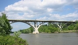
Mendota Bridge
Encyclopedia
The Mendota Bridge carries Minnesota
State Highway 55
over the Minnesota River
between Fort Snelling
and Mendota
. It is the final bridge over the Minnesota River before the Minnesota flows into the Mississippi River
at the "Meeting of the waters" or "Mendota" in the Dakota language
. Traffic on the north end of the bridge may turn onto the Highway 5 Fort Road Bridge to cross the Mississippi River into St. Paul, Minnesota. The skylines of both Minneapolis and St. Paul can be seen simultaneously from the bridge.
and Walter H. Wheeler. Turner also designed the Aerial Lift Bridge
in Duluth, Minnesota
and the Liberty Memorial Bridge between Bismarck
and Mandan, North Dakota
.
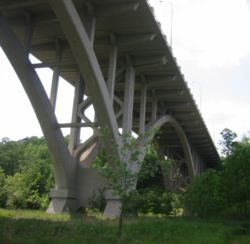
It was the longest continuous concrete arch bridge in the world when it was constructed in 1924-26. Often called the "mile-long bridge", it is actually 4,119 feet (1,255 meters) in length. It was added to the National Register of Historic Places
in 1979.
Between 1940 and 1965, the bridge also carried the multiplexed designation of Highway 100
.
From 1992-1994, the bridge was rebuilt from the arches up with the new deck two feet higher than the original. The old bridge was demolished down to the arches. A new wider deck was installed.
Minnesota
Minnesota is a U.S. state located in the Midwestern United States. The twelfth largest state of the U.S., it is the twenty-first most populous, with 5.3 million residents. Minnesota was carved out of the eastern half of the Minnesota Territory and admitted to the Union as the thirty-second state...
State Highway 55
Minnesota State Highway 55
Minnesota State Highway 55 is a highway in west-central, central, and east-central Minnesota, which runs from the North Dakota state line near Tenney and continues east and southeast to its eastern terminus at its intersection with U.S...
over the Minnesota River
Minnesota River
The Minnesota River is a tributary of the Mississippi River, approximately 332 miles long, in the U.S. state of Minnesota. It drains a watershed of nearly , in Minnesota and about in South Dakota and Iowa....
between Fort Snelling
Fort Snelling, Minnesota
Fort Snelling, originally known as Fort Saint Anthony, was a military fortification located at the confluence of the Minnesota River and Mississippi River in Hennepin County, Minnesota...
and Mendota
Mendota, Minnesota
Mendota is a city in Dakota County, Minnesota, United States. The name comes from the Dakota word for "where the waters meet." The population was 198 at the 2010 census.-History:...
. It is the final bridge over the Minnesota River before the Minnesota flows into the Mississippi River
Mississippi River
The Mississippi River is the largest river system in North America. Flowing entirely in the United States, this river rises in western Minnesota and meanders slowly southwards for to the Mississippi River Delta at the Gulf of Mexico. With its many tributaries, the Mississippi's watershed drains...
at the "Meeting of the waters" or "Mendota" in the Dakota language
Dakota language
Dakota is a Siouan language spoken by the Dakota people of the Sioux tribes. Dakota is closely related to and mutually intelligible with the Lakota language.-Dialects:...
. Traffic on the north end of the bridge may turn onto the Highway 5 Fort Road Bridge to cross the Mississippi River into St. Paul, Minnesota. The skylines of both Minneapolis and St. Paul can be seen simultaneously from the bridge.
History
The structure was designed by C.A.P. TurnerC.A.P. Turner
Claude Allen Porter Turner was an American structural engineer who designed a number of buildings and bridges, particularly in the midwestern U.S. states of Iowa, Minnesota, and Wisconsin....
and Walter H. Wheeler. Turner also designed the Aerial Lift Bridge
Aerial Lift Bridge
The Aerial Lift Bridge is a major landmark in the port city of Duluth, Minnesota. The span is a vertical lift bridge, which is rather uncommon, but it began life as an extremely rare transporter bridge—the first of just two such bridges ever constructed in the United States...
in Duluth, Minnesota
Duluth, Minnesota
Duluth is a port city in the U.S. state of Minnesota and is the county seat of Saint Louis County. The fourth largest city in Minnesota, Duluth had a total population of 86,265 in the 2010 census. Duluth is also the second largest city that is located on Lake Superior after Thunder Bay, Ontario,...
and the Liberty Memorial Bridge between Bismarck
Bismarck, North Dakota
Bismarck is the capital of the U.S. state of North Dakota and the county seat of Burleigh County. It is the second most populous city in North Dakota after Fargo. The city's population was 61,272 at the 2010 census, while its metropolitan population was 108,779...
and Mandan, North Dakota
Mandan, North Dakota
As of the census of 2000, there were 16,718 people, 6,647 households, and 4,553 families residing in the city. The population density was 1,642.8 per square mile . There were 6,958 housing units at an average density of 683.7 per square mile...
.
It was the longest continuous concrete arch bridge in the world when it was constructed in 1924-26. Often called the "mile-long bridge", it is actually 4,119 feet (1,255 meters) in length. It was added to the National Register of Historic Places
National Register of Historic Places
The National Register of Historic Places is the United States government's official list of districts, sites, buildings, structures, and objects deemed worthy of preservation...
in 1979.
Between 1940 and 1965, the bridge also carried the multiplexed designation of Highway 100
Minnesota State Highway 100
Minnesota State Highway 100 is a state highway in the Twin Cities region of Minnesota, which runs from its interchange with Interstate 494 in Bloomington and continues north to its northern terminus at its interchange with I-694 in Brooklyn Center...
.
From 1992-1994, the bridge was rebuilt from the arches up with the new deck two feet higher than the original. The old bridge was demolished down to the arches. A new wider deck was installed.