
Metro Local
Encyclopedia
Metro Local is a bus
system in Los Angeles County
operated by the Los Angeles County Metropolitan Transportation Authority
(Metro). This retronym
designation was placed to differentiate it from the Metro Rapid
service (before the advent of several Rapids, they were simply known as "Metro lines"). Metro Local buses cover both local, limited-stop, and shuttle bus services.
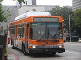
Metro Local buses are distinguished by their prominent orange color (although a number of older buses still carry the pre-2003 "Metro Bus" colors.)
There are bus lines that are operated under contract with MV Transportation
, Southland Transit, and Veolia Transportation.
 Metro buses are given route numbers that indicate the type of service offered. This method was devised originally by the SCRTD
, Metro's predecessor.
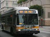
Metro Local buses can also be found on 400-series (4xx) and 500-series (5xx) routes, which are Metro Express
routes with different fare structures and routing.
However, The Orbital radio system (ATMS computer system) and AVL system were installed on the Thomas TL-960, Eldorado National EZ Rider II, NABI 40-LFW (20 vehicles which were re-installed) and Orion VI in 2008/2009.
The NABI 31-LFW were the first contracted buses to feature ATMS System inculded Automatic Voice Annuciation (AVA) and Automatic Passenger Counting (APC) for contracted lines.
In December 2010, the Automatic Voice Annuciation (AVA) and Automatic Passenger Counting (APC) were installed on 14 NABI 40-LFW #7000 and 7100 series as part of expanding the ATMS system for for service management and performance analyis.
However, 6 units didn't get the AVA and APC system installed which have been storaged this year in 2011, previosuly these 20 NABI 40-LFW buses did had the ATMS system but were removed in late 2005 when they transferred to Southland Transit at that time. Later on, all these 20 units got the Orbital radio system and Automatice Vehicle Locater system re-installed in 2008/2009 with 14 Vehicles getting the AVA and APC system re-installed in December of 2010. Two Orion VI did get the AVA and APC system installed which were a prototype for full ATMS system.
However, several more NABI 40-LFW that transferred to the contractors in these past years have retained the ATMS system and most of them already had feature the Transit TV monitor (front and rear, 2 screens).
In March 2011, Transit TV were installed on most contracted buses such as 2000 NABI 40-LFW 7000/7100 series (# 7057, 7058, 7059, 7060, 7061, 7065, 7110, 7113, 7114, 7115, 7119, 7120, 7130, 7140, 7148 and 7168), 2001 Orion VI 11000 series, and 2010 NABI 31-LFW #3100 series only. The Transit TV screens have been installed in the front only (1 screen).
Between October and December 2011, the AVA and APC system will be installed on 64 Orion VI buses and making contracted fleet be 100% full ATMS SmartBus. http://www.metro.net/board/Items/2011/10_October/20111020OPItem57.pdf
These routes were formerly operated by First Transit until October 2010.
Lines 266, 270, 577X and Dodger Stadium Express uses some 40-foot NABI buses (7000 series) are which the routes were owned by LACMTA.
NOTES: Lines 254, 256, 266 and 270 were formerly operated by First Transit (later MV Transportation) until 2005.
Line 605 was formerly operated by Transportation Concepts until 2005. Line 177 was formerly operated by Veolia Transportation until early 2010.
Dodger Stadium Express and Metro Express
Line 577X are also operated by Southland Transit (see the Metro Express page for details.)
NOTES: Most of these routes (Including Line 177) were formerly operated by Coach USA until 2003 and then Transportation Concepts until 2008.
Bus
A bus is a road vehicle designed to carry passengers. Buses can have a capacity as high as 300 passengers. The most common type of bus is the single-decker bus, with larger loads carried by double-decker buses and articulated buses, and smaller loads carried by midibuses and minibuses; coaches are...
system in Los Angeles County
Los Angeles County, California
Los Angeles County is a county in the U.S. state of California. As of 2010 U.S. Census, the county had a population of 9,818,605, making it the most populous county in the United States. Los Angeles County alone is more populous than 42 individual U.S. states...
operated by the Los Angeles County Metropolitan Transportation Authority
Los Angeles County Metropolitan Transportation Authority
The Los Angeles County Metropolitan Transportation Authority is the California state-chartered regional transportation planning agency and public transportation operating agency for the County of Los Angeles formed in 1993 out of a merger of the Southern California Rapid Transit District and the...
(Metro). This retronym
Retronym
A retronym is a type of neologism that provides a new name for an object or concept to differentiate the original form or version of it from a more recent form or version. The original name is most often augmented with an adjective to account for later developments of the object or concept itself...
designation was placed to differentiate it from the Metro Rapid
Metro Rapid
Metro Rapid is a bus rapid transit service in Los Angeles County, California that operates in mixed traffic environments and has fewer stops than the Metro Local service. The system is mainly operated by LACMTA. Two routes are operated by Santa Monica Transit and one by Culver City Transit...
service (before the advent of several Rapids, they were simply known as "Metro lines"). Metro Local buses cover both local, limited-stop, and shuttle bus services.
Metro Local buses are distinguished by their prominent orange color (although a number of older buses still carry the pre-2003 "Metro Bus" colors.)
There are bus lines that are operated under contract with MV Transportation
MV Transportation
MV Transportation, Inc., based in Fairfield, California., is the largest private provider of paratrasit services and the largest privately-owned transportation contracting firm in the United States...
, Southland Transit, and Veolia Transportation.
Route Numbers
Southern California Rapid Transit District
The Southern California Rapid Transit District , was the successor to the original Metropolitan Transit Authority after it virtually went bankrupt...
, Metro's predecessor.
- 1-99 (00-series, xx): Local bus service to/from Downtown Los AngelesDowntown Los AngelesDowntown Los Angeles is the central business district of Los Angeles, California, United States, located close to the geographic center of the metropolitan area...
and other areas. The route numbering begins at Route 2 (Sunset Boulevard, a route leading west from downtown) and proceeds counterclockwise around Downtown Los Angeles, ending at route 96 (Riverside Drive.) - 100-199 (100-series, 1xx): East-west service, not necessarily serving Downtown Los Angeles.
- 200-299 (200-series, 2xx): North-south service, not necessarily serving Downtown Los Angeles.
- 300-399 (300-series, 3xx): Limited-stopExpress busAn express bus service is a bus service that is intended to run faster than normal bus services between the same two commuter points....
versions of traditional local routes, which make fewer stops and generally operate during peak times. Most limited-stop routes are designated by placing a 3 before a main route number (example: the limited-stop version of route 2 is route 302). Most limited-stop routes have been replaced by Metro RapidMetro RapidMetro Rapid is a bus rapid transit service in Los Angeles County, California that operates in mixed traffic environments and has fewer stops than the Metro Local service. The system is mainly operated by LACMTA. Two routes are operated by Santa Monica Transit and one by Culver City Transit...
routes. Limited-stop routes are sometimes branded as Metro Limited. - 600-699 (600-series, 6xx): Shuttle and special event services.
Metro Local buses can also be found on 400-series (4xx) and 500-series (5xx) routes, which are Metro Express
Metro Express
Metro Express is a form of express bus service in Los Angeles County, California, operated by the Los Angeles County Metropolitan Transportation Authority. Buses are usually express for a portion of the route, then run either local or limited stop in other areas...
routes with different fare structures and routing.
Major Routes
All service operated by Metro as of June 26, 2011. Sector abbreviations are described here.| Route | Terminals | via | Notes | |
|---|---|---|---|---|
| Pacific Palisades Pacific Palisades, Los Angeles, California Pacific Palisades is an affluent neighborhood and district within the U.S. city of Los Angeles, California, located among Brentwood to the east, Malibu and Topanga to the west, Santa Monica to the southeast, the Santa Monica Bay to the southwest, and the Santa Monica Mountains to the north. The... Sunset Boulevard and Pacific Coast Highway |
Downtown LA Downtown Los Angeles Downtown Los Angeles is the central business district of Los Angeles, California, United States, located close to the geographic center of the metropolitan area... Hill Street and Venice Boulevard |
Sunset Boulevard |
|
|
| Westwood Westwood, Los Angeles, California Westwood is a neighborhood on the Westside of Los Angeles, California, United States. It is the home of the University of California, Los Angeles .-History:... -UCLA University of California, Los Angeles The University of California, Los Angeles is a public research university located in the Westwood neighborhood of Los Angeles, California, USA. It was founded in 1919 as the "Southern Branch" of the University of California and is the second oldest of the ten campuses... Le Conte Avenue and Westwood Boulevard |
Echo Park Sunset Boulevard and Alvarado Street |
|||
| West LA West Los Angeles, Los Angeles, California West Los Angeles is a district in Los Angeles, California, within a larger region known as the "Westside."-Geography and transportation:... Cotner Avenue and Santa Monica Boulevard (daytime) |
Downtown LA Hill Street and Venice Boulevard |
Santa Monica Boulevard |
|
|
| Santa Monica Santa Monica, California Santa Monica is a beachfront city in western Los Angeles County, California, US. Situated on Santa Monica Bay, it is surrounded on three sides by the city of Los Angeles — Pacific Palisades on the northwest, Brentwood on the north, West Los Angeles on the northeast, Mar Vista on the east, and... 2nd Street and Santa Monica Boulevard (owl) |
||||
| West Hollywood West Hollywood, California West Hollywood, a city of Los Angeles County, California, was incorporated on November 29, 1984, with a population of 34,399 at the 2010 census. 41% of the city's population is made up of gay men according to a 2002 demographic analysis by Sara Kocher Consulting for the City of West Hollywood... Santa Monica Boulevard and San Vicente Boulevard |
Downtown LA Main Street and Venice Boulevard (daytime and evenings; see notes) |
Temple Street, Melrose Avenue |
Avalon (LACMTA station) Avalon Station is a Los Angeles County Metro Rail station on the Green Line. It is located in the center median of Century Freeway above Avalon Boulevard in South Los Angeles... , via Main and San Pedro Streets. |
|
| South Hollywood Arden Boulevard and Arden Place |
Vermont/Beverly Station Vermont/Beverly (LACMTA station) Vermont/Beverly Station is a heavy-rail subway station in the Los Angeles County Metro Rail system. It is located at Vermont Avenue and Beverly Boulevard, in Los Angeles, near the border between East Hollywood and Wilshire Center. This station is served by the Red Line... (late nights) |
|||
| Beverly Hills Beverly Hills, California Beverly Hills is an affluent city located in Los Angeles County, California, United States. With a population of 34,109 at the 2010 census, up from 33,784 as of the 2000 census, it is home to numerous Hollywood celebrities. Beverly Hills and the neighboring city of West Hollywood are together... Beverly Boulevard and Pico Boulevard |
Trips are interlined with Line 37 in Downtown LA and continue to, or originate from West LA | Beverly Boulevard |
|
|
| Beverly Center Beverly Boulevard and La Cienega Boulevard |
||||
| Beverly Boulevard and Western Avenue (late nights) |
||||
| Century City Constellation Boulevard and Century Park West |
Downtown LA 5th Street and Wall Street |
3rd Street |
|
|
| Cedars-Sinai Medical Center Cedars-Sinai Medical Center Originally established as Kaspare Cohn Hospital in 1902, Cedars-Sinai Medical Center is a non-profit, tertiary 958-bed hospital and multi-specialty academic health science centre located in Los Angeles, California, US. Part of the Cedars-Sinai Health System, the hospital employs a staff of over... |
||||
| Wilshire/Western Station Wilshire/Western (LACMTA Station) Wilshire/Western Station is a heavy-rail subway station in the Los Angeles County Metro Rail system. It is located at Wilshire Boulevard and Western Avenue, in Los Angeles' Mid-Wilshire/Koreatown District... |
Montebello Station Montebello/Commerce (Metrolink station) Montebello/Commerce Metrolink is located at 2000 Flotilla Street in Montebello, California. It is owned and operated by the City of Montebello. The City also provides a shuttle, called Montebello Link, designed to connect Metrolink passengers with major employment centers. There are... |
6th Street, Whittier Boulevard |
|
|
| Downtown LA 5th/6th Streets and Broadway (evenings) |
East Los Angeles Whittier Boulevard and Garfield Avenue (evenings) |
|||
| Westwood Westwood Boulevard and Wilshire Boulevard (daytime and evenings) |
Downtown LA 7th Street and Maple Avenue |
Wilshire Boulevard |
|
|
| Santa Monica Main Street and Pico Boulevard (owl) |
||||
| Century City Constellation Boulevard and Century Park West |
Downtown LA Maple Avenue and 7th Street |
Olympic Boulevard |
|
|
| Miracle Mile Miracle Mile, Los Angeles, California The Miracle Mile in Los Angeles, California, is an area in the Mid-Wilshire region consisting of an almost two-mile stretch of Wilshire Boulevard between Fairfax and Western Avenues... Fairfax Avenue and Olympic Boulevard |
||||
| Country Club Park Country Club Park, Los Angeles, California Country Club Park is a neighborhood in the Mid-Wilshire area of Los Angeles, California.-Geography and transportation:Country Club Park's is bounded approximately by Olympic Boulevard to the north, Western Avenue to the east, Pico Boulevard to the south, and Crenshaw Boulevard to the west... Pico Boulevard and Rimpau Boulevard |
Indiana Station Indiana (Los Angeles Metro station) Indiana Station is an at-grade light rail station in the Los Angeles County Metro Rail system. It is located on Indiana Street between Gleason Street and 3rd Street in Los Angeles' Eastside. The station is served by the Gold Line.... |
Pico Boulevard, 1st Street |
|
|
| Little Tokyo/Arts District Station | ||||
| Venice Venice, Los Angeles, California Venice is a beachfront district on the Westside of Los Angeles, California, United States. It is known for its canals, beaches and circus-like Ocean Front Walk, a two-and-a-half mile pedestrian-only promenade that features performers, fortune-tellers, artists, and vendors... Main Street and Sunset Avenue (daytime and evenings) |
Downtown LA Main Street and 6th Street (daytime and evenings) |
Venice Boulevard |
|
|
| Santa Monica Ocean Avenue and Santa Monica Boulevard (owl) |
Downtown LAUnion Station Union Station (Los Angeles) Los Angeles Union Station is the main railway station in Los Angeles, California. The station has rail services by Amtrak and Amtrak California and Metrolink; light rail/subways are the Metro Rail Red Line, Purple Line, Gold Line. Bus rapid transport runs on the Silver Line... (owl) |
|||
| West LA Transit Center Washington Boulevard and Fairfax Avenue |
Downtown LA Main Street and Venice Boulevard (daytime) |
Washington Boulevard |
|
|
| Downtown LA 7th Street and Maple Avenue (evenings) |
||||
| West LA Transit Center Washington Boulevard and Fairfax Avenue |
Trips are interlined with Line 14 in Downtown LA and continue to, or originate from Beverly Hills | Adams Boulevard |
|
|
| Adams Boulevard and La Brea Avenue (late evenings) |
||||
| West LA Transit Center Washington Boulevard and Fairfax Avenue |
Downtown LA 17th-18th Streets and Broadway (Daytime) |
Jefferson Boulevard |
|
|
| Jefferson Boulevard and La Brea Avenue (late evenings) |
Downtown LA Spring Street and 7th Street (evenings) |
|||
| Downtown LA Union Station |
South Bay Galleria South Bay Galleria South Bay Galleria, formerly named Galleria at South Bay, is a mall in Redondo Beach outside of Los Angeles, California. It is anchored by Macy's, Kohl's and Nordstrom, as well as a 16-screen AMC Theatres multiplex.-History:... (Line 40) |
Martin Luther King Jr. Boulevard (All lines) Hawthorne Boulevard (Line 40) Stocker Street, La Tijera Boulevard (Line 42) |
|
|
| Downtown LA Broadway and 7th Street (late nights) |
LAX City Bus Center (Line 40 owl, Line 42 daytime) |
|||
| Lincoln Heights Lincoln Heights, Los Angeles, California -Geography and transportation:Lincoln Heights is bounded by the Los Angeles River on the west, the San Bernardino Freeway on the south, and Indiana Street on the east; the district's Eastern border is unclear due to the area's uneven terrain... Broadway and Thomas Street |
Rosewood San Pedro Street and Rosecrans Avenue |
Broadway |
|
|
| Harbor Freeway Station Harbor Freeway (LACMTA station) Harbor Freeway is a transport hub located within the Judge Harry Pregerson Interchange of Interstates I-105 and I-110 near Figueroa Street serving the Metro Green Line and the Silver Line and other bus services... |
||||
| Carson Avalon Boulevard and Carson Plaza Drive (owl) |
||||
| Trips are interlined with Line 10 and continue to, or originate from West Hollywood in Downtown LA | Avalon Station Avalon (LACMTA station) Avalon Station is a Los Angeles County Metro Rail station on the Green Line. It is located in the center median of Century Freeway above Avalon Boulevard in South Los Angeles... |
Main Street, San Pedro Street |
|
|
| Wilshire/Vermont Station Wilshire/Vermont (LACMTA Station) Wilshire/Vermont is a heavy-rail subway station in the Los Angeles Metro system. It is located at Wilshire Boulevard and Vermont Avenue, in Los Angeles' Mid-Wilshire/Koreatown District. This station is served by the Red Line and the Purple Line.-Location:... |
Compton Station Compton (LACMTA Station) Compton is a station on the Los Angeles County Metro Blue Line. It has an island platform, and is located in the median of Willowbrook Avenue at Compton Boulevard roughly in the center of Compton, California... (Line 51) |
Avalon Boulevard, San Pedro Street (All Lines) Compton Boulevard (Line 51) |
|
|
| Artesia Transit Center Artesia Transit Center Artesia Transit Center is a Metro Silver Line station and large bus station at southern end of the Harbor Transitway located in the southwest corner of Interstate 110 and State Route 91 in Los Angeles... (Lines 52/352) |
||||
| Downtown LA Beaudry Avenue and 5th Street |
CSU Dominguez Hills California State University The California State University is a public university system in the state of California. It is one of three public higher education systems in the state, the other two being the University of California system and the California Community College system. It is incorporated as The Trustees of the... |
Central Avenue |
|
|
| Avalon Station Avalon (LACMTA station) Avalon Station is a Los Angeles County Metro Rail station on the Green Line. It is located in the center median of Century Freeway above Avalon Boulevard in South Los Angeles... |
||||
| Downtown LA Figueroa Street and Sunset Boulevard |
Rosa Parks Station Imperial/Wilmington/Rosa Parks (LACMTA Station) Imperial/Wilmington/Rosa Parks Station is a major Los Angeles County Metro Rail station on the Blue Line and Green Line. The station, located at the intersection of Imperial Highway and Wilmington Avenue in Willowbrook, is a major transfer point for commuters.... (Line 55) |
Compton Avenue |
|
|
| Firestone Station Firestone (LACMTA Station) Firestone is a station on the Los Angeles County Metro Blue Line.The station has an island platform on the Blue Line right-of-way alongside Graham Avenue near the intersection of Firestone Boulevard in the unincorporated community of Walnut Park. It is next to Colonel Leon H... (Line 355 and Line 55 shortline) |
||||
| Downtown LA Spring Street and 7th Street (late evenings) |
Compton Station Compton (LACMTA Station) Compton is a station on the Los Angeles County Metro Blue Line. It has an island platform, and is located in the median of Willowbrook Avenue at Compton Boulevard roughly in the center of Compton, California... (owl) |
|||
| Downtown LA Figueroa Street and Sunset Boulevard |
Artesia Station Artesia (LACMTA Station) Artesia is a station on the Los Angeles County Metro Blue Line. It has an island platform, and is on the Blue Line right-of-way near Artesia Boulevard in the city of Compton, California. Artesia is a park and ride station with 380 parking spaces. The station is near the southern border of Compton,... (daytime and evenings) |
Santa Fe Avenue, Pacific Boulevard, Long Beach Boulevard |
|
|
| Long Beach Transit Mall (owl) |
||||
| Downtown LA Beaudry Avenue and 5th Street |
Hawaiian Gardens 226th Street and Norwalk Boulevard |
Telegraph Road |
|
|
| Los Cerritos Center Los Cerritos Center The Los Cerritos Center is a super regional shopping mall located in Cerritos, California. Since September 1971, the Los Cerritos Center has been an integral part of the city of Cerritos' tax revenue. The mall is the city's largest revenue source, producing $581 per square foot in sales in 2010... |
||||
| Norwalk Pioneer Boulevard and Rosecrans Avenue |
||||
| Koreatown Koreatown, Los Angeles, California Koreatown is a neighborhood in the Mid-Wilshire district of the city of Los Angeles, California known for its concentration of Korean American people and institutions... 8th Street and Western Avenue |
East LA East Los Angeles, California East Los Angeles is an unincorporated area and census-designated place in Los Angeles County, California, United States... Olympic Boulevard and Marianna Avenue |
8th and 9th Streets, Olympic Boulevard |
|
|
| Wilshire/Western Station Wilshire/Western (LACMTA Station) Wilshire/Western Station is a heavy-rail subway station in the Los Angeles County Metro Rail system. It is located at Wilshire Boulevard and Western Avenue, in Los Angeles' Mid-Wilshire/Koreatown District... (weekdays) |
Montebello Station | |||
| Trips are interlined with Line 84 in Downtown LA and continue to, or originate from Eagle Rock | Montebello Town Center Montebello Town Center This page is under construction. Thank you for your patience.The Montebello Town Center is an attractive, completely enclosed mall that offers a plethora of shopping opportunities.... |
Cesar E. Chavez Avenue |
|
|
| Downtown LA Broadway and 7th Street (late evenings) |
East LA Rowan Avenue and Dozier Street |
|||
| Downtown LA Hill Street and 17th Street |
El Monte Station | Marengo Street, Garvey Avenue |
|
|
| Downtown LA Grand Avenue/Olive Street and 7th Street (late evenings) |
||||
| Downtown LA Olive Street and 18th Street-Venice Boulevard |
El Monte Station | Valley Boulevard |
|
|
| Downtown LA Grand Avenue/Olive Street and 7th Street (late nights) |
||||
| Downtown LA Olive Street and 18th Street-Venice Boulevard (Daytime) |
South Arcadia Longden Avenue and Myrtle Avenue (Lines 78/378) |
Mission Road, Huntington Drive (All Lines) Main Street, Las Tunas Drive (Lines 78/378) |
|
|
| Downtown LA Grand Avenue/Olive Street and 7th Street (Line 78 evenings) |
||||
| El Sereno Huntington Drive and Maycrest Avenue (Line 79 evenings) |
Arcadia St. Joseph Street and 2nd Avenue (Line 79) |
|||
| Eagle Rock Eagle Rock, Los Angeles, California In 1909, Hill Avenue, now Hill Drive, was one of Eagle Rock's most beautiful streets. Other streets were Royal Drive , Acacia Street , Kenilworth Avenue , Highland Avenue , and Fairmont Avenue... Colorado Boulevard and Eagledale Avenue |
Harbor Freeway Station Harbor Freeway (LACMTA station) Harbor Freeway is a transport hub located within the Judge Harry Pregerson Interchange of Interstates I-105 and I-110 near Figueroa Street serving the Metro Green Line and the Silver Line and other bus services... |
Figueroa Street |
|
|
| Eagle Rock Eagle Rock Boulevard and York Boulevard |
Downtown LA Venice Boulevard and Main-Hill Streets |
York Boulevard, Pasadena Avenue (24 hour) Eagle Rock Boulevard (owl) |
|
|
| Figueroa Street and Colorado Boulevard (owl) |
Downtown LA Hill Street and 7th Street (late evenings) |
|||
| Eagle Rock Colorado Street and Eagledale Avenue |
Trips are interlined with Line 68 in Downtown LA and continue to, or originate from Montebello Town Center | Eagle Rock Boulevard, Cypress Avenue |
|
|
| Glassell Park Eagle Rock Boulevard and Verdugo Road |
Downtown LA Broadway and 7th Street (late evenings) |
|||
| Sunland Foothill Boulevard and Fenwick Street |
Downtown LA Hill Avenue and Venice Boulevard |
Glendale Avenue, Cañada Boulevard, Foothill Boulevard (All Lines) Pennsylvania Avenue (Line 90) La Crescenta Avenue (Line 91) |
|
|
| Glendale Glendale, California Glendale is a city in Los Angeles County, California, United States. As of the 2010 Census, the city population is 191,719, down from 194,973 at the 2000 census. making it the third largest city in Los Angeles County and the 22nd largest city in the state of California... Glendale Avenue and San Fernando Road (late evenings) |
||||
| Burbank Station Downtown Burbank (Metrolink station) The Burbank Metrolink Station, sometimes referred to as the Burbank Transportation Center, is a Metrolink rail station near downtown Burbank, California. It is served by Metrolink's Antelope Valley Line to Lancaster and Ventura County Line to Montalvo, Ventura and both terminating at Los Angeles... |
Downtown LA Main Street and Olympic Boulevard |
Glendale Boulevard, Brand Boulevard, Glenoaks Boulevard |
Sylmar/San Fernando (Metrolink station) Sylmar/San Fernando is a Metrolink rail station in the city of San Fernando, California. It is served by Metrolink's Antelope Valley Line from Los Angeles Union Station to Lancaster... |
|
| Sun Valley Lankershim Boulevard and Strathern Avenue |
Downtown LA Hill Street and Venice Boulevard |
San Fernando Road |
|
|
| Sylmar Station Sylmar/San Fernando (Metrolink station) Sylmar/San Fernando is a Metrolink rail station in the city of San Fernando, California. It is served by Metrolink's Antelope Valley Line from Los Angeles Union Station to Lancaster... (weekends) |
||||
| Baldwin Village Coliseum Street and La Brea Avenue |
Huntington Park Palm Place and Seville Avenue |
Coliseum Street, Exposition Boulevard, Jefferson Boulevard |
|
|
| West Hollywood Santa Monica Boulevard and San Vicente Boulevard |
Vernon Pacific Boulevard and Santa Fe Avenue |
Vernon Avenue, La Cienega Boulevard |
|
|
| Leimert Park Crenshaw Boulevard and Martin Luther King Jr. Boulevard (late evenings) |
||||
| Marina Del Rey Washington Boulevard and Palawan Way (Line 108) |
Pico Rivera Paramount Boulevard and Slauson Avenue |
Slauson Avenue |
|
|
| Culver City Culver City, California Culver City is a city in western Los Angeles County, California. As of the 2010 census, the city had a population of 38,883, up from 38,816 at the 2000 census. It is mostly surrounded by the city of Los Angeles, but also shares a border with unincorporated areas of Los Angeles County. Culver... Mesmer Avenue and Major Street (Line 358 and Line 108 shortline) |
||||
| Playa Vista E.A. Way and Jefferson Boulevard (weekdays and Saturdays) |
Bell Gardens Granger and Florence Avenue |
Centinela Avenue, Hyde Park Boulveard, Gage Avenue (daily) Jefferson Boulevard (weekdays and Saturdays) |
|
|
| Culver City Culver City, California Culver City is a city in western Los Angeles County, California. As of the 2010 census, the city had a population of 38,883, up from 38,816 at the 2000 census. It is mostly surrounded by the city of Los Angeles, but also shares a border with unincorporated areas of Los Angeles County. Culver... Mesmer Avenue and Major Street |
||||
| LAX City Bus Center |
Norwalk Station Norwalk (LACMTA station) Norwalk is a Los Angeles County Metro Rail station on the Green Line. Located in Norwalk, California, it is the eastern terminus of the Green Line... |
Florence Avenue |
|
|
| Inglewood Transit Center | Bell Gardens Bell Gardens, California Bell Gardens is a city in Los Angeles County, California. The population was 42,072 at the 2010 census, down from 44,054 at the 2000 census.Bell Gardens is notable for being one of only five Los Angeles County cities to permit casino gambling... Florence Avenue and Garfield Avenue |
|||
| Playa Del Rey Pacific Avenue and Culver Boulevard |
Norwalk Station Norwalk (LACMTA station) Norwalk is a Los Angeles County Metro Rail station on the Green Line. Located in Norwalk, California, it is the eastern terminus of the Green Line... |
Manchester and Firestone Boulevards |
|
|
| Westchester Westchester, Los Angeles, California Westchester is a suburban neighborhood in western Los Angeles, California, United States. It is home to Los Angeles International Airport , Loyola Marymount University , and Otis College of Art and Design.-Geography:... Manchester Boulevard and Sepulveda Boulevard |
||||
| LAX City Bus Center |
Lakewood Station Lakewood (LACMTA station) Lakewood is a Los Angeles County Metro Rail station on the Green Line. It is located in the center median of Century Freeway at the interchange with Lakewood Boulevard in Downey, California. It is not necessarily named for the city of Lakewood, California as Metro Rail usually names most of their... |
Century Boulevard, 103rd Street, Tweedy Boulevard |
|
|
| Aviation Station | Whittier Whittwood Town Center |
Imperial Highway |
|
|
| Norwalk Station | ||||
| Canoga Park Canoga Park, Los Angeles, California Canoga Park is a district in the San Fernando Valley region of Los Angeles, California, United States about 25 miles northwest of Downtown Los Angeles.... Topanga Canyon Boulevard and Sherman Way |
Universal City Station Universal City (LACMTA Station) Universal City Station is a heavy-rail subway station in the Los Angeles County Metro Rail system. It is located on Lankershim Boulevard, across from the entrance to Universal Studios, in the Los Angeles, California community of Studio City... |
Ventura Boulevard |
|
|
| Woodland Hills Victory Boulevard and Topanga Canyon Boulevard (late evenings) |
||||
| Woodland Hills Woodland Hills, Los Angeles, California Woodland Hills is a district in the city of Los Angeles, California.Woodland Hills is located in the southwestern area of the San Fernando Valley, east of Calabasas and west of Tarzana, with Warner Center in its northern section... Ventura Boulevard and Fallbrook Avenue |
North Hollywood Station North Hollywood (LACMTA Station) North Hollywood is a heavy-rail subway station in the Los Angeles County Metro Rail system. It is located at the intersection of Lankershim Boulevard and Chandler Boulevard in the North Hollywood District of Los Angeles. This station is served by the Red Line as well as the Orange Line BRT service... |
Fallbrook Avenue, Roscoe Boulevard (All lines) Lankershim Boulevard (Line 353) Vineland Avenue (Line 152) |
|
|
| Burbank Station | Sherman Oaks Moorpark Street and Van Nuys Boulevard |
Olive Avenue, Riverside Drive |
|
|
| Universal City Station | ||||
| Van Nuys Station Van Nuys (LACMTA Station) For the Amtrak/Metrolink station in Van Nuys, see Van Nuys .Van Nuys is a station on the Los Angeles Metro Orange Line. It is named after adjacent Van Nuys Boulevard, which travels north-south and crosses the east-west busway route and is located in the Los Angeles district of Van Nuys... |
Hollywood Hollywood, Los Angeles, California Hollywood is a famous district in Los Angeles, California, United States situated west-northwest of downtown Los Angeles. Due to its fame and cultural identity as the historical center of movie studios and movie stars, the word Hollywood is often used as a metonym of American cinema... Highland Avenue and Santa Monica Boulevard |
Burbank Boulevard, Vineland Avenue, Highland Avenue |
|
|
| Panorama City Panorama City, Los Angeles, California Panorama City is a district in the San Fernando Valley region of the city of Los Angeles, California. It is known as the San Fernando Valley's first planned community.-Description:... Parthenia Street and Tobias Avenue (owl as Line 656) |
||||
| Chatsworth Station Chatsworth (Amtrak station) The Chatsworth Amtrak/Metrolink Station, sometimes referred to as the Chatsworth Transportation Center, is an Amtrak and Metrolink rail station in the Los Angeles community of Chatsworth, California, USA. It is served by both Amtrak's Pacific Surfliner from San Luis Obispo to San Diego and... |
Sherman Oaks Moorpark Street and Van Nuys Boulevard |
Devonshire Street, Woodman Avenue |
|
|
| Westlake Village Westlake Village, California Westlake Village is a planned community that straddles the Los Angeles and Ventura county line. The eastern portion is the incorporated city Westlake Village, located on the western edge of Los Angeles County, California. The city, located in the region known as the Conejo Valley, encompasses half... |
Warner Center Transit Hub Warner Center (LACMTA Station) Warner Center is a transit center and a station on the Metro Orange Line. It is currently the western terminus of the Orange Line, but a proposed extension of the line northbound beside Canoga Avenue to the Amtrak/Metrolink station in Chatsworth would provide a second, forked western terminus... |
Thousand Oaks Boulevard, Agoura Road, Ventura Boulevard |
|
|
| Thousand Oaks Transit Center (weekdays) |
||||
| West Hills Medical Center | Sun Valley Sun Valley Sun Valley is the name of several places in the United States of America:*Sun Valley, Idaho, a ski area and resort community in central Idaho*Sun Valley, Los Angeles, in the San Fernando Valley*Sun Valley, Nevada, a suburb north of Reno... Vineland Avenue and Cantara Street (Line 163) |
Sherman Way (All Lines) Lankershim Boulevard (Line 363) |
|
|
| North Hollywood Station (Line 363) |
||||
| Burbank Station | West Hills Valley Circle Boulevard and Valley Circle Terrace |
Victory Boulevard |
|
|
| Burbank Station | West Hills Valley Circle Boulevard and Valley Circle Terrace |
Vanowen Street |
|
|
| Chatsworth Station Chatsworth (Amtrak station) The Chatsworth Amtrak/Metrolink Station, sometimes referred to as the Chatsworth Transportation Center, is an Amtrak and Metrolink rail station in the Los Angeles community of Chatsworth, California, USA. It is served by both Amtrak's Pacific Surfliner from San Luis Obispo to San Diego and... |
Sun Valley Glenoaks Boulevard and Branford Street |
Nordhoff Street, Osborne Street |
|
|
| Sunland Summitrose Street and Tinker Street |
West Hills Medical Center (weekdays) |
Sunland Boulevard (daily) Saticoy Street (weekdays) |
|
|
| Burbank Airport Bob Hope Airport Bob Hope Airport is a public airport located 3 miles northwest of the central business district of Burbank, a city in Los Angeles County, California, United States... (weekends) |
||||
| Hollywood/Vine Station Hollywood/Vine (LACMTA Station) Hollywood/Vine is a subway station on the Red Line of the Los Angeles Metro in Hollywood, Los Angeles.-Location:As the name implies, Hollywood/Vine station lies below the intersection of Hollywood Boulevard and Vine Street. The central station of the three subway stops in Hollywood, it is within... |
Altadena Altadena, California Altadena is an unincorporated area and census-designated place in Los Angeles County, California, United States, approximately from the downtown Los Angeles Civic Center, and directly north of the city of Pasadena, California... Altadena Drive and Lake Avenue (Line 180) |
Hollywood Boulevard, Los Feliz Boulevard, Colorado Boulevard (All lines) Lake Avenue (Line 180) |
|
|
| Sierra Madre Villa Station Sierra Madre Villa (LACMTA station) Sierra Madre Villa Station is a freeway-median light rail station in the Los Angeles County Metro Rail system. It is located above Sierra Madre Villa Avenue in the median of the 210 Freeway in Pasadena, California. The station is served by the Gold Line.... (Line 181) |
||||
| Pasadena Colorado Boulevard and Lake Avenue (Line 180 owl) |
||||
| Sherman Oaks Galleria | Burbank 1st Street and Angeleno Avenue |
Magnolia Boulevard |
|
|
| Glendale Station Glendale (Amtrak station) The Glendale Amtrak/Metrolink Station, often referred to as the Glendale Transportation Center, is an Amtrak and Metrolink rail station in the city of Glendale, California... (weekdays) |
||||
| El Monte Station | Cal Poly Pomona California State Polytechnic University, Pomona California State Polytechnic University, Pomona, or Cal Poly Pomona, is a public university located in Pomona, California, United States... |
Ramona Boulevard (Line 190) Valley Boulevard (Line 194) |
|
|
| Echo Park Echo Park, Los Angeles, California Echo Park is a hilly neighborhood in Los Angeles, California, northwest of Downtown Los Angeles and southeast of Hollywood.-History:At the end of the 19th century, when the hills were still covered with native vegetation, a horse-drawn streetcar line served the dirt road that is now Echo Park Avenue... Montana Street and Logan Street |
Exposition Park Hill Street and Martin Luther King Jr. Boulevard |
Alvarado Street, Hoover Street |
|
|
| Glendale Adventist Medical Center Glendale Adventist Medical Center Glendale Adventist Medical Center is a non-profit organization located in the Los Angeles suburb of Glendale, California. GAMC is one of the city's oldest businesses, founded in 1905, a year before Glendale was incorporated as a city... |
Wilshire/Vermont Station | Silverlake Boulevard |
|
|
| Los Feliz Los Feliz, Los Angeles, California Los Feliz, also Rancho Los Feliz is an affluent, hilly neighborhood in the Hollywood district of Los Angeles, California, named after its land grantee José Vicente Feliz.... Vermont Avenue and Hollywood Boulevard |
Athens Athens, California Athens is an unincorporated community in Los Angeles County, California. It lies at an elevation of 171 feet . Athens is located in the South Los Angeles region, near the intersection of the Century and the Harbor freeways... Vermont Avenue and 120th Street |
Vermont Avenue |
|
|
| Vermont/Sunset Station Vermont/Sunset (LACMTA Station) Vermont/Sunset Station is a heavy-rail subway station in the Los Angeles County Metro Rail system. It is located at Vermont Avenue and Sunset Boulevard in Los Angeles, among the East Hollywood neighborhoods of Los Feliz, Silver Lake, and Little Armenia. This station is served by the Red Line... |
Vermont/I-105 Station | Normandie Avenue |
|
|
| Hollywood Western Avenue and Hollywood Boulevard-Franklin Avenue |
Athens Western Avenue and Imperial Highway |
Western Avenue |
|
|
| Crenshaw Station (weekday early mornings and late evenings, weekends) |
||||
| Hollywood/Vine Station Hollywood/Vine (LACMTA Station) Hollywood/Vine is a subway station on the Red Line of the Los Angeles Metro in Hollywood, Los Angeles.-Location:As the name implies, Hollywood/Vine station lies below the intersection of Hollywood Boulevard and Vine Street. The central station of the three subway stops in Hollywood, it is within... |
South Bay Galleria South Bay Galleria South Bay Galleria, formerly named Galleria at South Bay, is a mall in Redondo Beach outside of Los Angeles, California. It is anchored by Macy's, Kohl's and Nordstrom, as well as a 16-screen AMC Theatres multiplex.-History:... |
Vine Street, Crenshaw Boulevard |
|
|
| Hollywood/Vine Station Hollywood/Vine (LACMTA Station) Hollywood/Vine is a subway station on the Red Line of the Los Angeles Metro in Hollywood, Los Angeles.-Location:As the name implies, Hollywood/Vine station lies below the intersection of Hollywood Boulevard and Vine Street. The central station of the three subway stops in Hollywood, it is within... |
Hawthorne Station Hawthorne (LACMTA station) Hawthorne/I-105 is a Los Angeles County Metro Rail station on the Green Line. It is located at Hawthorne Boulevard in the median of the Century Freeway in Hawthorne, California. Due to its proximity, the station also serves Inglewood, California and the unincorporated area of Lennox, California... |
La Brea Avenue |
|
|
| Hollywood/Highland Station Hollywood/Highland (LACMTA Station) Hollywood/Highland Station is a heavy-rail subway station in the Los Angeles County Metro Rail system. It is located at the intersection of Hollywood Boulevard and Highland Avenue in the Hollywood District of Los Angeles... |
Lennox Hillcrest Boulevard and Nutwood Street |
|||
| Vermont/Sunset Station Vermont/Sunset (LACMTA Station) Vermont/Sunset Station is a heavy-rail subway station in the Los Angeles County Metro Rail system. It is located at Vermont Avenue and Sunset Boulevard in Los Angeles, among the East Hollywood neighborhoods of Los Feliz, Silver Lake, and Little Armenia. This station is served by the Red Line... (owl) |
West LA Transit Center Washington Boulevard and Fairfax Avenue |
Hollywood Boulevard, Fairfax Avenue |
|
|
| Hollywood/Vine Station | ||||
| Sun Valley Sun Valley Sun Valley is the name of several places in the United States of America:*Sun Valley, Idaho, a ski area and resort community in central Idaho*Sun Valley, Los Angeles, in the San Fernando Valley*Sun Valley, Nevada, a suburb north of Reno... Vineland Avenue and Cantara Street |
Hollywood/Highland Station | Hollywood Way, Barham Boulevard |
|
|
| Sylmar Sylmar, Los Angeles, California Sylmar is a district in the San Fernando Valley region of the City of Los Angeles, California. The northernmost neighborhood in the city, Sylmar is located east of Interstate 5 and north of the city of San Fernando... Olive View Medical Center |
Universal City Station Universal City (LACMTA Station) Universal City Station is a heavy-rail subway station in the Los Angeles County Metro Rail system. It is located on Lankershim Boulevard, across from the entrance to Universal Studios, in the Los Angeles, California community of Studio City... |
San Fernando Road, Lankershim Boulevard |
|
|
| Sun Valley Lankershim Boulevard and San Fernando Road |
North Hollywood Station North Hollywood (LACMTA Station) North Hollywood is a heavy-rail subway station in the Los Angeles County Metro Rail system. It is located at the intersection of Lankershim Boulevard and Chandler Boulevard in the North Hollywood District of Los Angeles. This station is served by the Red Line as well as the Orange Line BRT service... |
|||
| Sylmar Station Sylmar/San Fernando (Metrolink station) Sylmar/San Fernando is a Metrolink rail station in the city of San Fernando, California. It is served by Metrolink's Antelope Valley Line from Los Angeles Union Station to Lancaster... |
Studio City Ventura Place and Ventura Boulevard |
Laurel Canyon Boulevard (daily) Hubbard Street (weekdays) |
|
|
| Los Angeles Mission College Los Angeles Mission College Los Angeles Mission College is a two-year community college located in Sylmar neighborhood of Los Angeles in the San Fernando Valley region of Los Angeles, California, United States. It is part of the Los Angeles Community College District... (weekdays) |
||||
| Lake View Terrace Lake View Terrace, Los Angeles, California Lake View Terrace is a suburb district in the north east quadrant of the San Fernando Valley region of the City of Los Angeles, California.Surrounding areas include the Angeles National Forest, Little Tujunga Canyon, Big Tujunga Canyon, Hansen Dam, Kagel Canyon, and a portion of the Verdugo Mountains... Eldridge Avenue and Terra Bella Street |
Sherman Oaks Sherman Oaks, Los Angeles, California Sherman Oaks is an affluent district in the San Fernando Valley area of the city of Los Angeles, California. In contrast to much of the Valley, the area is relatively urbanized, with commercial skyscrapers along Ventura Boulevard as well as scattered throughout... Moorpark Street and Van Nuys Boulevard |
Van Nuys Boulevard |
|
|
| Westwood Federal Building (early mornings and late evenings) |
Pacoima Pacoima, Los Angeles, California Pacoima is a district in the San Fernando Valley region of the city of Los Angeles, California.It is bordered by the Los Angeles districts of Mission Hills on the west, Arleta on the south, Sun Valley on the southeast, Lake View Terrace on the northeast, and by the city of San Fernando on the north... Van Nuys Boulevard and Glenoaks Boulevard |
|||
| Sherman Oaks Galleria Sherman Oaks Galleria Sherman Oaks Galleria is a shopping mall and business center located in the Sherman Oaks neighborhood of Los Angeles, California, United States, at the corner of Ventura and Sepulveda Boulevards in the San Fernando Valley.... |
Los Angeles Mission College Los Angeles Mission College Los Angeles Mission College is a two-year community college located in Sylmar neighborhood of Los Angeles in the San Fernando Valley region of Los Angeles, California, United States. It is part of the Los Angeles Community College District... |
Sepulveda Boulevard, Brand Boulevard |
|
|
| Encino Balboa Boulevard and Ventura Boulevard |
Sylmar Station Sylmar/San Fernando (Metrolink station) Sylmar/San Fernando is a Metrolink rail station in the city of San Fernando, California. It is served by Metrolink's Antelope Valley Line from Los Angeles Union Station to Lancaster... (Line 236) |
Balboa Boulevard (All lines) Woodley Avenue, Victory Boulevard, Van Nuys Boulevard (Line 237) |
|
|
| Granada Hills Balboa Boulevard and Rinaldi Street (Line 237 shortline) |
Sherman Oaks Moorpark Street and Van Nuys Boulevard (Line 237) |
|||
| Northridge Northridge, Los Angeles, California Northridge is a community located in the San Fernando Valley region of the City of Los Angeles, California, United States.The 1994 Northridge earthquake is named for the place based on early estimates of the location of the quake's epicenter; however, further refinements showed it to be technically... Reseda Boulevard and Devonshire Street |
Universal City Station Universal City (LACMTA Station) Universal City Station is a heavy-rail subway station in the Los Angeles County Metro Rail system. It is located on Lankershim Boulevard, across from the entrance to Universal Studios, in the Los Angeles, California community of Studio City... |
Reseda Boulevard |
|
|
| Tarzana Reseda Boulevard and Ventura Boulevard |
||||
| Porter Ranch Town Center | Woodland Hills Ventura Boulevard and Winnetka Avenue |
Tampa Avenue (Line 242) Winnetka Avenue (Line 243) |
|
|
| Chatsworth Station Chatsworth (Amtrak station) The Chatsworth Amtrak/Metrolink Station, sometimes referred to as the Chatsworth Transportation Center, is an Amtrak and Metrolink rail station in the Los Angeles community of Chatsworth, California, USA. It is served by both Amtrak's Pacific Surfliner from San Luis Obispo to San Diego and... |
Woodland Hills Ventura Boulevard and Topanga Canyon Boulevard |
De Soto Avenue (Line 244) Topanga Canyon Boulevard (Line 245) |
|
|
| Artesia Transit Center Artesia Transit Center Artesia Transit Center is a Metro Silver Line station and large bus station at southern end of the Harbor Transitway located in the southwest corner of Interstate 110 and State Route 91 in Los Angeles... |
San Pedro Korean Bell Site |
Avalon Boulevard, Pacific Avenue |
|
|
| San Pedro Pacific Avenue and 21st Street (owl) |
||||
| Cypress Park Cypress Park, Los Angeles, California Cypress Park is a neighborhood in Northeast Los Angeles. It is located at the confluence of the Los Angeles River and Arroyo Seco and is less than 2.5 miles north of Downtown Los Angeles... Avenue 28 and Idell Street |
Long Beach Station Long Beach (LACMTA station) Long Beach/I-105 is a Los Angeles County Metro Rail station on the Green Line. It is located in the center median of Century Freeway at the interchange with Long Beach Boulevard in Lynwood, California. It is not necessarily named for the city of Long Beach, California as Metro Rail usually names... |
Avenue 26, Daly Street, Soto Street |
|
|
| LAC-USC Medical Center Station Los Angeles County-USC Medical Center (LACMTA station) Los Angeles County-USC Medical Center is a Silver Line station on El Monte Busway located near the Los Angeles County-USC Medical Center in Los Angles.-Layout:... |
Huntington Park Huntington Park, California Huntington Park is a city in Los Angeles County, California, United States. As of the 2010 census, the city had a total population of 58,114, down from 61,348 at the 2000 census.- History :... Palm Place and Seville Avenue |
|||
| Montecito Heights Avenue 42 and Figueroa Street (weekdays) |
Boyle Heights Soto Street and Olympic Boulevard |
Soto Street, Mercury Avenue (daily) Griffin Avenue (weekdays) |
|
|
| Lincoln Heights Lincoln Park Avenue and Broadway (weekends) |
||||
| Altadena Loma Alta Drive and Fair Oaks Avenue |
Artesia Station | Fair Oaks Avenue, Atlantic Boulevard |
|
|
| Pasadena Fair Oaks Avenue and Colorado Boulevard |
Lynwood Atlantic Boulevard and King Boulevard |
|||
| Altadena Altadena Drive and Lake Avenue |
City of Hope | Altadena Drive, Michillinda Avenue, Duarte Road |
|
|
| Pico Rivera Passons Boulevard and Jackson Street |
Lakewood Center Lakewood Center Lakewood Center is a super-regional shopping mall in Lakewood, California. It is anchored by JCPenney, Macy's , Forever 21, and Target. Macy's formerly operated a . store in the mall, but closed due to the Federated-May merger. At , the Lakewood Center is ranked among the largest retail shopping... |
Paramount Boulevard |
|
|
| El Monte Station | Altadena Altadena Drive and Lake Avenue |
Temple City Boulevard, Del Mar Boulevard, Lincoln Avenue |
|
|
| JPL | El Monte Station | Washington Boulevard, Baldwin Avenue |
|
|
| Olive View Medical Center | Sunland Summitrose Street and Tinker Street |
Foothill Boulevard |
|
|
| Sylmar Station Sylmar/San Fernando (Metrolink station) Sylmar/San Fernando is a Metrolink rail station in the city of San Fernando, California. It is served by Metrolink's Antelope Valley Line from Los Angeles Union Station to Lancaster... |
Burbank Station Downtown Burbank (Metrolink station) The Burbank Metrolink Station, sometimes referred to as the Burbank Transportation Center, is a Metrolink rail station near downtown Burbank, California. It is served by Metrolink's Antelope Valley Line to Lancaster and Ventura County Line to Montalvo, Ventura and both terminating at Los Angeles... |
Glenoaks Boulevard |
|
|
| Rancho Palos Verdes Palos Verdes Drive South and Seacove Drive |
Artesia Transit Center Artesia Transit Center Artesia Transit Center is a Metro Silver Line station and large bus station at southern end of the Harbor Transitway located in the southwest corner of Interstate 110 and State Route 91 in Los Angeles... |
Artesia Boulevard, Hawthorne Boulevard |
|
|
Contracted Bus Lines
First Transit had operated all of the contracted routes until transferring some lines to other contractors and turning their operations in to MV Transportation after October 2010. ATE Management and Service operated most of the routes until First Transit took over. Until June 2007, most contractor buses had different fareboxes. Farebox changes occurred after a few buses operated by Southland Transit had Metro's previous fareboxes that were not functioning. Until 2010, Most contractor buses were not equipped with SmartBus technology except for several NABI 40-LFW #7000 series and 1998 New Flyer D40LF 3000 series.However, The Orbital radio system (ATMS computer system) and AVL system were installed on the Thomas TL-960, Eldorado National EZ Rider II, NABI 40-LFW (20 vehicles which were re-installed) and Orion VI in 2008/2009.
The NABI 31-LFW were the first contracted buses to feature ATMS System inculded Automatic Voice Annuciation (AVA) and Automatic Passenger Counting (APC) for contracted lines.
In December 2010, the Automatic Voice Annuciation (AVA) and Automatic Passenger Counting (APC) were installed on 14 NABI 40-LFW #7000 and 7100 series as part of expanding the ATMS system for for service management and performance analyis.
However, 6 units didn't get the AVA and APC system installed which have been storaged this year in 2011, previosuly these 20 NABI 40-LFW buses did had the ATMS system but were removed in late 2005 when they transferred to Southland Transit at that time. Later on, all these 20 units got the Orbital radio system and Automatice Vehicle Locater system re-installed in 2008/2009 with 14 Vehicles getting the AVA and APC system re-installed in December of 2010. Two Orion VI did get the AVA and APC system installed which were a prototype for full ATMS system.
However, several more NABI 40-LFW that transferred to the contractors in these past years have retained the ATMS system and most of them already had feature the Transit TV monitor (front and rear, 2 screens).
In March 2011, Transit TV were installed on most contracted buses such as 2000 NABI 40-LFW 7000/7100 series (# 7057, 7058, 7059, 7060, 7061, 7065, 7110, 7113, 7114, 7115, 7119, 7120, 7130, 7140, 7148 and 7168), 2001 Orion VI 11000 series, and 2010 NABI 31-LFW #3100 series only. The Transit TV screens have been installed in the front only (1 screen).
Between October and December 2011, the AVA and APC system will be installed on 64 Orion VI buses and making contracted fleet be 100% full ATMS SmartBus. http://www.metro.net/board/Items/2011/10_October/20111020OPItem57.pdf
MV Transportation
Currently, MV Transportation operates 40-foot Orion buses and NABI 31-footer Low Floor buses. Line 125, 128, 130, 205, and 232 uses 40-foot Orion buses (11000 Series). Lines 607 and 625 uses NABI 31-footer buses (3100 series). As of November 2010, The new operator for these contracted routes is MV Transportation.These routes were formerly operated by First Transit until October 2010.
| Route | Terminals | via | Notes | |
|---|---|---|---|---|
| Plaza El Segundo | Norwalk Station | Rosecrans Avenue |
|
|
| Compton Station | Cerritos Towne Center Cerritos Towne Center The Cerritos Towne Center is a power centre located in the center of Cerritos, California that combines retailing, office, and entertainment in one master project. The Cerritos Center for the Performing Arts is located within the southwestern part of the project... |
Alondra Boulevard |
|
|
| Redondo Beach Redondo Beach, California Redondo Beach is one of the three Beach Cities located in Los Angeles County, California, United States. The population was 66,748 at the 2010 census, up from 63,261 at the 2000 census. The city is located in the South Bay region of the greater Los Angeles area.Redondo Beach was originally part of... Torrance Boulevard and Broadway |
Los Cerritos Center Los Cerritos Center The Los Cerritos Center is a super regional shopping mall located in Cerritos, California. Since September 1971, the Los Cerritos Center has been an integral part of the city of Cerritos' tax revenue. The mall is the city's largest revenue source, producing $581 per square foot in sales in 2010... |
Artesia Boulevard |
|
|
| San Pedro 13th Street and Gaffey Avenue |
Rosa Parks Station | Wilmington Avenue, Vermont Avenue, Western Avenue |
|
|
| LAX City Bus Center |
Long Beach Transit Mall | Sepulveda Boulevard, Pacific Coast Highway, Anaheim Street |
|
|
| Inglewood Transit Center | Windsor Hills Slauson Avenue and La Brea Avenue |
Beach Avenue, La Tijera Boulevard, West Boulevard (operates in a loop) |
|
|
| LA County Superior Court | LAX World Way West |
Imperial Highway, Pershing Drive |
|
|
Southland Transit
Lines 177, 254, 256, 577X (uses Blue NABI 40-LFW buses) and 605 uses small buses which are NABI 31-LFW (3100 series).Lines 266, 270, 577X and Dodger Stadium Express uses some 40-foot NABI buses (7000 series) are which the routes were owned by LACMTA.
NOTES: Lines 254, 256, 266 and 270 were formerly operated by First Transit (later MV Transportation) until 2005.
Line 605 was formerly operated by Transportation Concepts until 2005. Line 177 was formerly operated by Veolia Transportation until early 2010.
| Route | Terminals | via | Notes | |
|---|---|---|---|---|
| JPL | Sierra Madre Villa Station | California Boulevard, Walnut Street |
|
|
| East LA East Los Angeles (region) East Los Angeles is the portion of the City of Los Angeles that lies east of Downtown Los Angeles, the Los Angeles River and the unincorporated areas of Lincoln Heights, west of the San Gabriel Valley, East Los Angeles and City Terrace, south of Cypress Park, and north of Vernon, California and... Rowan Avenue and Dozier Street |
103rd Street Station | Lorena Street, Boyle Avenue |
|
|
| Altadena Mendocino Street and Lake Avenue |
Commerce Commerce, California Commerce is a city located in southeast Los Angeles County, California, United States. The population was 12,823 at the 2010 census, up from 12,568 at the 2000 census. It is bordered by Vernon on the west, Los Angeles on the northwest, East Los Angeles on the north, Montebello on the east, Downey... Eastern Avenue and Union Pacific Avenue |
Eastern Avenue, Avenue 64, Colorado Boulevard, Hill Avenue |
|
|
| Sierra Madre Villa Station | Lakewood Center Lakewood Center Lakewood Center is a super-regional shopping mall in Lakewood, California. It is anchored by JCPenney, Macy's , Forever 21, and Target. Macy's formerly operated a . store in the mall, but closed due to the Federated-May merger. At , the Lakewood Center is ranked among the largest retail shopping... |
Rosemead Boulevard, Lakewood Boulevard |
|
|
| Monrovia Monrovia, California Monrovia is a city located in the foothills of the San Gabriel Mountains in the San Gabriel Valley of Los Angeles County, California, United States. The population was 36,590 at the 2010 census, down from 36,929 at the 2000 census... Primrose Avenue and Foothill Boulevard |
Norwalk Station | Myrtle Avenue, Peck Road, Workman Mill Road |
|
|
| LAC-USC Medical Center | Boyle Heights Grande Vista Avenue and Olympic Boulevard |
Soto Street, 4th Street, Lorena Street |
|
|
Dodger Stadium Express and Metro Express
Metro Express
Metro Express is a form of express bus service in Los Angeles County, California, operated by the Los Angeles County Metropolitan Transportation Authority. Buses are usually express for a portion of the route, then run either local or limited stop in other areas...
Line 577X are also operated by Southland Transit (see the Metro Express page for details.)
Veolia Transportation
Lines 96, 218, and 603 operate NABI 31-LFW #3100 series all times. Line 167 and 603 uses NABI 40-LFW (7000-7100 series buses). The Veolia Transportation yard is located just north of the Chinatown Metro Gold Line station.NOTES: Most of these routes (Including Line 177) were formerly operated by Coach USA until 2003 and then Transportation Concepts until 2008.
| Route | Terminals | via | Notes | |
|---|---|---|---|---|
| Burbank Station | Downtown LA Grand Avenue-Olive Street and Venice Boulevard |
Riverside Drive |
|
|
| Chatsworth Station Chatsworth (Amtrak station) The Chatsworth Amtrak/Metrolink Station, sometimes referred to as the Chatsworth Transportation Center, is an Amtrak and Metrolink rail station in the Los Angeles community of Chatsworth, California, USA. It is served by both Amtrak's Pacific Surfliner from San Luis Obispo to San Diego and... |
Studio City Ventura Boulevard and Goodland Avenue |
Plummer Street, Coldwater Canyon Avenue |
|
|
| Studio City Ventura Place and Ventura Boulevard |
Cedars-Sinai Medical Center Cedars-Sinai Medical Center Originally established as Kaspare Cohn Hospital in 1902, Cedars-Sinai Medical Center is a non-profit, tertiary 958-bed hospital and multi-specialty academic health science centre located in Los Angeles, California, US. Part of the Cedars-Sinai Health System, the hospital employs a staff of over... |
Laurel Canyon Boulevard |
|
|
| Glendale Galleria Glendale Galleria The Glendale Galleria is a large three-story regional shopping mall located in downtown Glendale, California and is the second largest mall in Los Angeles County.- History :... |
Grand Station | Fletcher Drive, Rampart Boulevard, Hoover Street |
|
|