
McKinley, Alabama
Encyclopedia
McKinley is an unincorporated community
in Marengo County
, Alabama
, United States
. McKinley had a post office
at one time, but it no longer exists. Although a thriving community in its earliest years, it has since dwindled into obscurity.
, was granted a charter there on December 7, 1848. The name of the community was changed to McKinley in 1849 in honor of John McKinley
, a U.S. Senator
and Associate Justice of the United States Supreme Court.
The town grew rapidly in the 1850s and became the second largest in Marengo County, after Demopolis
. Around thirty large plantation
s surrounded the settlement. By 1860 the community had Methodist
, Baptist
, and Presbyterian
churches, two schools, several general stores, a brick drug store, livery stables, two-story carriage repair shop, saddle
and harness
shop, hotel, three shoe shops, an undertaker
, tanning
yard, brickyard
, and grist mill.
In 1860 a fire destroyed everything on the east side of Main Street, except for the hotel. A second fire in 1869 destroyed practically the entire town. It never recovered from the combined effects of the fires, American Civil War
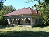
, and a changing agricultural situation. Only the Baptist church and a few homes now remain.
Unincorporated area
In law, an unincorporated area is a region of land that is not a part of any municipality.To "incorporate" in this context means to form a municipal corporation, a city, town, or village with its own government. An unincorporated community is usually not subject to or taxed by a municipal government...
in Marengo County
Marengo County, Alabama
Marengo County is a county of the U.S. state of Alabama. It is named in honor of a battlefield near Turin, Italy, where the French defeated the Austrians on June 14, 1800. As of 2010 the population was 21,027...
, Alabama
Alabama
Alabama is a state located in the southeastern region of the United States. It is bordered by Tennessee to the north, Georgia to the east, Florida and the Gulf of Mexico to the south, and Mississippi to the west. Alabama ranks 30th in total land area and ranks second in the size of its inland...
, United States
United States
The United States of America is a federal constitutional republic comprising fifty states and a federal district...
. McKinley had a post office
United States Postal Service
The United States Postal Service is an independent agency of the United States government responsible for providing postal service in the United States...
at one time, but it no longer exists. Although a thriving community in its earliest years, it has since dwindled into obscurity.
History
First known as New Ruin, the community was settled in 1815 and incorporated in 1848. The Phister Lodge #90, a masonic lodgeMasonic Lodge
This article is about the Masonic term for a membership group. For buildings named Masonic Lodge, see Masonic Lodge A Masonic Lodge, often termed a Private Lodge or Constituent Lodge, is the basic organisation of Freemasonry...
, was granted a charter there on December 7, 1848. The name of the community was changed to McKinley in 1849 in honor of John McKinley
John McKinley
John McKinley was a U.S. Senator from the state of Alabama and an associate justice of the United States Supreme Court.Born in Culpeper County, Virginia, his family moved to Kentucky when he was an infant...
, a U.S. Senator
United States Senate
The United States Senate is the upper house of the bicameral legislature of the United States, and together with the United States House of Representatives comprises the United States Congress. The composition and powers of the Senate are established in Article One of the U.S. Constitution. Each...
and Associate Justice of the United States Supreme Court.
The town grew rapidly in the 1850s and became the second largest in Marengo County, after Demopolis
Demopolis, Alabama
Demopolis is the largest city in Marengo County, Alabama, United States. The population was 7,483 at the time of the 2010 United States Census....
. Around thirty large plantation
Plantation
A plantation is a long artificially established forest, farm or estate, where crops are grown for sale, often in distant markets rather than for local on-site consumption...
s surrounded the settlement. By 1860 the community had Methodist
Methodism
Methodism is a movement of Protestant Christianity represented by a number of denominations and organizations, claiming a total of approximately seventy million adherents worldwide. The movement traces its roots to John Wesley's evangelistic revival movement within Anglicanism. His younger brother...
, Baptist
Baptist
Baptists comprise a group of Christian denominations and churches that subscribe to a doctrine that baptism should be performed only for professing believers , and that it must be done by immersion...
, and Presbyterian
Presbyterianism
Presbyterianism refers to a number of Christian churches adhering to the Calvinist theological tradition within Protestantism, which are organized according to a characteristic Presbyterian polity. Presbyterian theology typically emphasizes the sovereignty of God, the authority of the Scriptures,...
churches, two schools, several general stores, a brick drug store, livery stables, two-story carriage repair shop, saddle
Saddle
A saddle is a supportive structure for a rider or other load, fastened to an animal's back by a girth. The most common type is the equestrian saddle designed for a horse, but specialized saddles have been created for camels and other creatures...
and harness
Horse harness
A horse harness is a type of horse tack that allows a horse or other equine to pull various horse-drawn vehicles such as a carriage, wagon or sleigh. Harnesses may also be used to hitch animals to other loads such as a plow or canal boat....
shop, hotel, three shoe shops, an undertaker
Funeral director
A funeral director , also known as a mortician or undertaker, is a professional involved in the business of funeral rites. These tasks often entail the embalming and burial or cremation of the dead, as well as the planning and arrangement of the actual funeral ceremony...
, tanning
Tanning
Tanning is the making of leather from the skins of animals which does not easily decompose. Traditionally, tanning used tannin, an acidic chemical compound from which the tanning process draws its name . Coloring may occur during tanning...
yard, brickyard
Brickyard
A brickyard is a place or yard where the earthen building material called bricks are made, fired, and stored, or sometimes sold or otherwise distributed from.-See also:...
, and grist mill.
In 1860 a fire destroyed everything on the east side of Main Street, except for the hotel. A second fire in 1869 destroyed practically the entire town. It never recovered from the combined effects of the fires, American Civil War
American Civil War
The American Civil War was a civil war fought in the United States of America. In response to the election of Abraham Lincoln as President of the United States, 11 southern slave states declared their secession from the United States and formed the Confederate States of America ; the other 25...
, and a changing agricultural situation. Only the Baptist church and a few homes now remain.