

Maujahn Moor
Encyclopedia
Sinkhole
A sinkhole, also known as a sink, shake hole, swallow hole, swallet, doline or cenote, is a natural depression or hole in the Earth's surface caused by karst processes — the chemical dissolution of carbonate rocks or suffosion processes for example in sandstone...
. It is located a good two kilometres west of the town of Dannenberg
Dannenberg (Elbe)
Dannenberg is a town in the district Lüchow-Dannenberg, in Lower Saxony, Germany. It is situated near the river Elbe, approx. 30 km north of Salzwedel, and 50 km south-east of Lüneburg...
between the villages of Thunpadel
Karwitz
Karwitz is a municipality in the district Lüchow-Dannenberg, in Lower Saxony, Germany....
and Schmarsau
Dannenberg (Elbe)
Dannenberg is a town in the district Lüchow-Dannenberg, in Lower Saxony, Germany. It is situated near the river Elbe, approx. 30 km north of Salzwedel, and 50 km south-east of Lüneburg...
in northeastern Lower Saxony
Lower Saxony
Lower Saxony is a German state situated in north-western Germany and is second in area and fourth in population among the sixteen states of Germany...
.
Location
The bog is located on the eastern border of the D28 Lüneburg HeathLüneburg Heath
The Lüneburg Heath is a large area of heath, geest and woodland in northeastern part of the state of Lower Saxony in northern Germany. It forms part of the hinterland for the cities of Hamburg, Hanover, and Bremen and is named after the town of Lüneburg. Most of the area is a nature reserve...
natural region
Natural regions of Germany
This division of Germany into major natural regions takes account primarily of geomorphological, geological, hydrological and pedological criteria in order to divide the country into large, physical units with a common geographical basis...
, within the Lower Drawehn
Drawehn
The Drawehn is a partly wooded and partly agricultural region of hills in the northeastern part of the German state of Lower Saxony, lying between the districts of Lüneburg and Uelzen in the west and Lüchow-Dannenberg in the east.- Definition :...
, the transition to the D29 Wendland and Altmark
Altmark
The Altmark is a historic region in Germany, comprising the northern third of Saxony-Anhalt. As the initial territory of the Brandenburg margraves, it is sometimes referred to as the "Cradle of Prussia", as by Otto von Bismarck, a native from Schönhausen near Stendal.- Geography :The Altmark is...
natural region. Culturally, the Drawehn is usually associated with the Wendland. The Maujahn Moor is protected from the Atlantic macroclimate
Macroclimate
In viticulture, there are several levels of regional climates that are used to describe the terroir or immutable characteristics of an area. These levels can be as broad as a macroclimate which includes entire wine regions or as small as a microclimate which includes the unique environment around...
of Lower Saxony by the presence of the eastern slopes of the East Hanoverian end moraines (also known as the Göhrde-Drawehn Hills
Drawehn
The Drawehn is a partly wooded and partly agricultural region of hills in the northeastern part of the German state of Lower Saxony, lying between the districts of Lüneburg and Uelzen in the west and Lüchow-Dannenberg in the east.- Definition :...
) formed during the Saalian glaciation and the climate is therefore clearly sub-continental.The surface of the moor lies 25 metres above sea level; the geest
Geest (topography)
Geest is a type of slightly raised landscape that occurs in the plains of in Northern Germany, the Northern Netherlands and Denmark. It is a landscape of sandy and gravelly soils, usually mantled by a heathland vegetation, comprising glacial deposits left behind after the last ice age during the...
hillocks surrounding it reach heights of just above 50 metres. The most exposed point in the High Drawehn - is the Hoher Mechtin
Hoher Mechtin
At a height of the Hoher Mechtin is the highest elevation in the Wendland in the district of Lüchow-Dannenberg in northern Germany, and is at the same time a significant high point on the entire North German Plain. It lies roughly at the centre point of the Drawehn ridge, which is also described...
which climbs to 142 metres above sea level - is 10 kilometres away.
Description
This terrain hollow was formed about 7000 years ago as a result of the collapse of a salt domeSalt dome
A salt dome is a type of structural dome formed when a thick bed of evaporite minerals found at depth intrudes vertically into surrounding rock strata, forming a diapir....
that was leached by underground groundwater action - exactly as happened to the Bullenkuhle in the district of Gifhorn. Thanks to stratigraphic research of the bog carried out by Lesemann (1969), we know that, initially, a carr
Carr (topography)
A carr is a type of waterlogged, wooded terrain that, typically, represents a succession stage between the original reedy swamp and the eventual formation of forest in a sub-maritime climate....
with a covering of peat moss developed on the valley bottom. About 500 years ago there was clearly another collapse which resulted in the creation of two larger sinkhole
Sinkhole
A sinkhole, also known as a sink, shake hole, swallow hole, swallet, doline or cenote, is a natural depression or hole in the Earth's surface caused by karst processes — the chemical dissolution of carbonate rocks or suffosion processes for example in sandstone...
s. These dolines
Sinkhole
A sinkhole, also known as a sink, shake hole, swallow hole, swallet, doline or cenote, is a natural depression or hole in the Earth's surface caused by karst processes — the chemical dissolution of carbonate rocks or suffosion processes for example in sandstone...
filled with water, the peat moss layer rose and covered the surface of the lake. Today this enclosed, floating layer of grass and peat has a thickness of between 2.5 and 4 metres and is capable of load-bearing. Underneath the eastern sinkhole is a body of water and mud up to 16 metres deep. Even above ground the terrain shows the characteristic relief of a sinkhole: the eastern bog hollow is semi-circular and surrounded by steep walls up to 15 metres high, covered with oak
Oak
An oak is a tree or shrub in the genus Quercus , of which about 600 species exist. "Oak" may also appear in the names of species in related genera, notably Lithocarpus...
and pine
Pine
Pines are trees in the genus Pinus ,in the family Pinaceae. They make up the monotypic subfamily Pinoideae. There are about 115 species of pine, although different authorities accept between 105 and 125 species.-Etymology:...
.
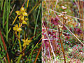
The rounded, oval, more or less treeless surface of the bog in the eastern sinkhole covers about 2 hectares (4.9 acre) and is classified as a 'living', i.e. growing, mesotrophic transition moor (Zwischenmoor or Übergangsmoor). It has vegetation typical of a raised bog however. In addition to various peat mosses, certain types of cottongrass characterise its appearance, particularly (Hare's-tail and Common Cottongrass
Common Cottongrass
Common Cottongrass is a plant from the sedge family, so even though it looks like a form of grass, technically it is not. It grows in acidic wetlands and peat bogs all over northern parts of Europe, Asia and North America...
); other typical species are the Common cranberry, Bog-rosemary
Bog-rosemary
Andromeda polifolia, commonly known as Bog-rosemary, is a heath found across northern parts of the Northern Hemisphere. It is the only member of its genus. Bog rosemary is only found in bogs in cold peat-accumulating areas....
, Cross-leaved heath and Common heather, various sedge
Sedge
- Plants :* Acorus calamus, sweet flag, a plant in the Acoraceae family* Any of the plants in the family Cyperaceae- Animals :* A collective noun for several species of birds, including bitterns, cranes and herons* Sedge-fly, caddisfly- Other uses :...
s, White beak-sedge (Rhynchospora alba) and the rare Rannoch-rush (Scheuchzeria palustris).
On the periphery is a strip of carr
Carr (topography)
A carr is a type of waterlogged, wooded terrain that, typically, represents a succession stage between the original reedy swamp and the eventual formation of forest in a sub-maritime climate....
which is dominated by Grey Willow
Salix atrocinerea
Salix atrocinerea, commonly called grey willow, is a species of willow....
and Alder Buckthorn bushes as well as Downy Birch
Downy Birch
Betula pubescens is a species of birch, native and abundant throughout northern Europe, Iceland, northern Asia and also Greenland....
. In places Bog-bean and Bog Arum may also be found in the undergrowth. The western part of this waterlogged terrain is more fen-like (Niedermoor), with reed beds and tall herbaceous vegetation as well as birch
Birch
Birch is a tree or shrub of the genus Betula , in the family Betulaceae, closely related to the beech/oak family, Fagaceae. The Betula genus contains 30–60 known taxa...
and alder
Alder
Alder is the common name of a genus of flowering plants belonging to the birch family . The genus comprises about 30 species of monoecious trees and shrubs, few reaching large size, distributed throughout the North Temperate Zone and in the Americas along the Andes southwards to...
trees. Information about the fauna of the region may be found in the book by Timm (1983).
Unlike the normal situation with these transition moors, the raised centre of the moor body, currently only a few decimetres high, is thought to be at its climatic climax. Any further succession
Ecological succession
Ecological succession, is the phenomenon or process by which a community progressively transforms itself until a stable community is formed. It is a fundamental concept in ecology, and refers to more or less predictable and orderly changes in the composition or structure of an ecological community...
into a true raised bog (Hochmoor) - with its surface bulging noticeably in the middle, from which the groundwater has fully retreated and which is only fed by rainwater, is not expected. This may be put down to its orographic situation, particularly the kettle hole formation, as well as the very low annual precipitation in the area of well under 600 millimetres per year. This makes the region very different from the Atlantic and sub-Atlantic raised bogs of western and central Lower Saxony.
No information is available about the derivation of the name Maujahn, however it may have Slavic
Slavic languages
The Slavic languages , a group of closely related languages of the Slavic peoples and a subgroup of Indo-European languages, have speakers in most of Eastern Europe, in much of the Balkans, in parts of Central Europe, and in the northern part of Asia.-Branches:Scholars traditionally divide Slavic...
roots, like the Drawehn
Drawehn
The Drawehn is a partly wooded and partly agricultural region of hills in the northeastern part of the German state of Lower Saxony, lying between the districts of Lüneburg and Uelzen in the west and Lüchow-Dannenberg in the east.- Definition :...
.
Threats and conservation
Like the majority of the few still remaining raised and tranistion bogs in North Germany, the Maujahn is threatened by drainage and changes in nutrient levels.The quality of this valuable biotope is at risk because the surface of the moor dries out from time to time, causing a mineralisation of the peat
Peat
Peat is an accumulation of partially decayed vegetation matter or histosol. Peat forms in wetland bogs, moors, muskegs, pocosins, mires, and peat swamp forests. Peat is harvested as an important source of fuel in certain parts of the world...
layer and encouraging the settlement of trees (downy birch, alder, pine, willow). This threatens to oust the highly specialised, moorland flora and fauna that only thrive in isolated spots. The reason for this intermittent loss of water is that there have been some particularly dry years (for example 2003: 435 mm/a in Lüchow) and the fact that drainage of the hollow southwest into Prissersche Bach valley the by a ditch has not been fully prevented. Periodic clearance work by nature conservationists has enabled the invading trees to be removed from the surface of the bog.
In addition the diffusion of nutrients from agriculture in the area (Abdrift) and atmospheric pollution (i.e. the deposition and mobilisation of nitrogen), particularly in central Europe, is a problem. This leads to the unnatural fertilisation of the oligotrophic to mesotrophic moor and alters the mix of plant communities
Association (ecology)
An association is the "ultimate classification level" of ecological systems. Local conditions permit several understory species to coexist with the same overstory dominants, and associations refer to the many co-occurring species rather than just the few dominant ones.Associations have:#A...
.
- Visitors should note that the moor is out of bounds due to its sensitive quaking bog surface. Its vegetation is very sensitive to being trodden on; in addition there is a danger of falling through the surface in places.
Due to its regional landscape uniqueness as a biotope
Biotope
Biotope is an area of uniform environmental conditions providing a living place for a specific assemblage of plants and animals. Biotope is almost synonymous with the term habitat, but while the subject of a habitat is a species or a population, the subject of a biotope is a biological community.It...
and geotope
Geotope
Geotope is the geological component of the abiotic matrix present in an ecotope. Example geotopes might be: an exposed outcrop of rocks, an erratic boulder, a grotto or ravine, a cave, an old stone wall marking a property boundary, and so forth....
and its importance as a habitat for numerous rare, plants and animals, the Maujahn has been declared a nature reserve
Nature reserve
A nature reserve is a protected area of importance for wildlife, flora, fauna or features of geological or other special interest, which is reserved and managed for conservation and to provide special opportunities for study or research...
(area: 37 hectares (91.4 acre)). The area was also designated by the EU Commission in Brüssel as a Special Area of Conservation
Special Area of Conservation
A Special Area of Conservation is defined in the European Union's Habitats Directive , also known as the Directive on the Conservation of Natural Habitats and of Wild Fauna and Flora...
as part of the European conservation project Natura 2000
Natura 2000
Natura 2000 is an ecological network of protected areas in the territory of the European Union.-Origins:In May 1992, the governments of the European Communities adopted legislation designed to protect the most seriously threatened habitats and species across Europe. This legislation is called the...
.
The Legend of Maujahn
Unsurprisingly, there are also legends about how the Maujahn was formed. These stories have been passed down the generations in various forms. This version was told by Miss Ungewitter, a teacher at Dannenberg Primary School (around 1970).- Not far from the village of Thunpadel is a hollow in the ground, called Maujahn. Legend has it that at this spot there was once a high hill on which a castle stood, and in which there lived a knight of the heath with many armed servants. He was feared far and wide for his robberies. From the heights of his castle he could survey the roads round about from above. Many merchants were robbed and dragged off into the castle. They only regained their freedom in return for a high ransom.
- One day the heath knight appeared before Count Adalbert on the moor. The count was shocked, but received him in friendly fashion. Great was his dismay, however, when the knight asked him for the hand of his daughter, the beautiful Agnes. Fearing revenge, Count Adalbert assented. The wedding was fixed for Midsummer's Day. How disconsolate was the lovely Agnes! Day and night she prayed to God, to prevent her becoming the wife of the robber baron. She promised in return to build a monastery.
- The nearer the day of the wedding came, the heavier was her heart. On Midsummer's Day the bride was with her family in the church at Dannenberg awaiting the groom, the heath knight. But that morning the knight had seen a train of wares coming along the road and wanted to seize it and bring it to the castle. His chief adviser urged him not to do this on his wedding day. He rejected the advice with the words: "Beautiful Agnes can wait, the little dove won't fly away!"
- When he was underway, a heavy storm arose, so that one of his servants begged him to turn back. With the words: "Now may your god be merciful" he slew him with his sword. At once there was a brilliant flash of lightning and a loud thunderclap! Everyone lay prostrate as if they were dead. When the servants came to their senses again, the heath knight had disappeared. They hurried to the castle. But that had gone too. On the site of the castle, before which they stood, was a deep hole. God had punished the ungodly heath knight.
- When news of the demise of the knight reached the church, everyone was joyful, especially the beautiful Agnes. She did as she had promised God and had the Abbey of St. George built near Dannenberg. Right across the land, the people were glad that the heath knight was dead. Out of gratitude they built a large stone with the inscription: "Do not sin, you people; God will not be mocked."
Sources
- B. Lesemann: Pollenanalytische Untersuchungen zur Vegetationsgeschichte of the Hannoverschen Wendlandes. Flora (Abt. B), Morph. Geobot., 1969, 158: 480-518
- T. Timm: Faunistische Charakterisierung and Bewertung of the subkontinentalen Maujahn Moores in NE-Lower Saxony. Abh. naturwiss. Ver., Hamburg 1983, (NF) 25: 169-186
- R. Tüxen: The Maujahn. Veröff. Geobot. Inst., Zürich 1962, 37: 267-301