

Hoher Mechtin
Encyclopedia
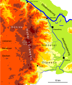

Wendland
Wendland may refer to either of the following regions or people:*Wendland may refer to a region once inhabited by Wends, an old Germanic term for Slavic tribes living in close proximity to the Germanic tribes:...
in the district of Lüchow-Dannenberg in northern Germany
Germany
Germany , officially the Federal Republic of Germany , is a federal parliamentary republic in Europe. The country consists of 16 states while the capital and largest city is Berlin. Germany covers an area of 357,021 km2 and has a largely temperate seasonal climate...
, and is at the same time a significant high point on the entire North German Plain
North German plain
The North German Plain or Northern Lowland is one of the major geographical regions of Germany. It is the German part of the North European Plain...
. It lies roughly at the centre point of the Drawehn
Drawehn
The Drawehn is a partly wooded and partly agricultural region of hills in the northeastern part of the German state of Lower Saxony, lying between the districts of Lüneburg and Uelzen in the west and Lüchow-Dannenberg in the east.- Definition :...
ridge, which is also described as the East Hanoverian gravel or end moraine. (Osthannoversche Kies- or Endmoräne). The area is part of the Ostheide
Ostheide
Ostheide is a Samtgemeinde in the district of Lüneburg, in Lower Saxony, Germany. It is situated approx. 8 km east of Lüneburg. Its seat is in the village Barendorf.-Division of the municipality:...
division of the Lüneburg Heath
Lüneburg Heath
The Lüneburg Heath is a large area of heath, geest and woodland in northeastern part of the state of Lower Saxony in northern Germany. It forms part of the hinterland for the cities of Hamburg, Hanover, and Bremen and is named after the town of Lüneburg. Most of the area is a nature reserve...
.
Debris consisting of sand, loam, gravel, stones and glacial erratic
Glacial erratic
A glacial erratic is a piece of rock that differs from the size and type of rock native to the area in which it rests. "Erratics" take their name from the Latin word errare, and are carried by glacial ice, often over distances of hundreds of kilometres...
s several metres across was transported southwards by the glacier flowing from Scandinavia in a series of advances in the Saale glaciation, leaving the Drawehn
Drawehn
The Drawehn is a partly wooded and partly agricultural region of hills in the northeastern part of the German state of Lower Saxony, lying between the districts of Lüneburg and Uelzen in the west and Lüchow-Dannenberg in the east.- Definition :...
behind as an end moraine after it melted. Today the area is predominantly covered in pine forest, but mixed deciduous forest comprising oak, birch, beech and other trees dominates the scene in a few places, especially on the high spots and slopes.
On the summit of the Hoher Mechtin is a wooden observation tower that could be used by walkers until recently (but is currently closed).