

Maps of Cornwall
Encyclopedia
Kingdom of Cornwall
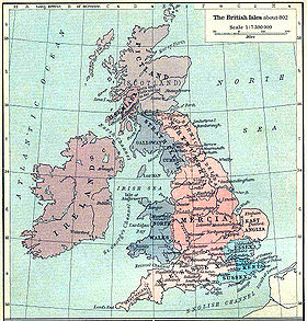
The Kingdom of Cornwall was an independent polity in southwest Britain during the Early Middle Ages, roughly coterminous with the modern English county of Cornwall. During the sub-Roman and early medieval periods Cornwall was evidently part of the kingdom of Dumnonia, which included most of the...
during the period of the Heptarchy
Heptarchy
The Heptarchy is a collective name applied to the Anglo-Saxon kingdoms of south, east, and central Great Britain during late antiquity and the early Middle Ages, conventionally identified as seven: Northumbria, Mercia, East Anglia, Essex, Kent, Sussex and Wessex...
(which referred to the separate kingdoms which made up Anglo-Saxon
Anglo-Saxons
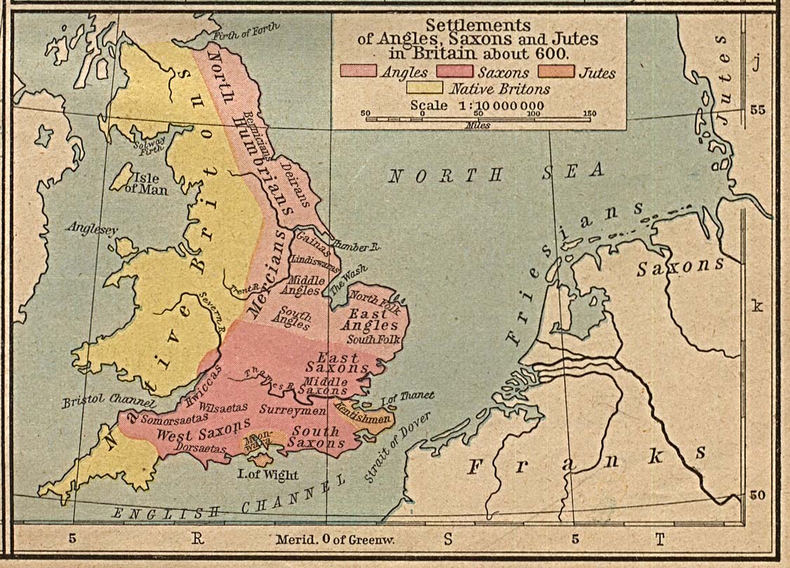
Anglo-Saxon is a term used by historians to designate the Germanic tribes who invaded and settled the south and east of Great Britain beginning in the early 5th century AD, and the period from their creation of the English nation to the Norman conquest. The Anglo-Saxon Era denotes the period of...
Ængla Land or England
England
England is a country that is part of the United Kingdom. It shares land borders with Scotland to the north and Wales to the west; the Irish Sea is to the north west, the Celtic Sea to the south west, with the North Sea to the east and the English Channel to the south separating it from continental...
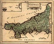
). To the Anglo-Saxons it was known as West Wales. (The Old English word Wealas, meaning "foreigners" in the sense of Britons, gave its name to Wales, and was also applied to Cornwall, as "West Wealas" meaning Western foreigners.) One of the oldest maps still in existence depicting Cornwall
Cornwall
Cornwall is a unitary authority and ceremonial county of England, within the United Kingdom. It is bordered to the north and west by the Celtic Sea, to the south by the English Channel, and to the east by the county of Devon, over the River Tamar. Cornwall has a population of , and covers an area of...
is the 1290 Hereford Mappa Mundi
Hereford Mappa Mundi
The Hereford Mappa Mundi is a mappa mundi, of a form deriving from the T and O pattern, dating to ca. 1300. It is currently on display in Hereford Cathedral in Hereford, England...
currently on display in Hereford Cathedral
Hereford Cathedral
The current Hereford Cathedral, located at Hereford in England, dates from 1079. Its most famous treasure is Mappa Mundi, a mediæval map of the world dating from the 13th century. The cathedral is a Grade I listed building.-Origins:...
in the United Kingdom
United Kingdom
The United Kingdom of Great Britain and Northern IrelandIn the United Kingdom and Dependencies, other languages have been officially recognised as legitimate autochthonous languages under the European Charter for Regional or Minority Languages...
. Many maps of the British Isles
British Isles
The British Isles are a group of islands off the northwest coast of continental Europe that include the islands of Great Britain and Ireland and over six thousand smaller isles. There are two sovereign states located on the islands: the United Kingdom of Great Britain and Northern Ireland and...
prior to the 17th century showed Cornwall (Cornubia
Cornubia
Cornubia can be:*SS Cornubia *Cornwall, an old Latin name*A geologists' name for a former island which existed in the Mesozoic and during continental drift and orogeny became an area of land in or around Cornwall....
/Cornwallia/Kernow) as a nation on a par with Wales
Wales
Wales is a country that is part of the United Kingdom and the island of Great Britain, bordered by England to its east and the Atlantic Ocean and Irish Sea to its west. It has a population of three million, and a total area of 20,779 km²...
and examples include the maps of Sebastian Münster
Sebastian Münster
Sebastian Münster , was a German cartographer, cosmographer, and a Hebrew scholar.- Life :Münster was born at Ingelheim near Mainz, the son of Andreas Munster. He completed his studies at the Eberhard-Karls-Universität Tübingen in 1518. His graduate adviser was Johannes Stöffler.He was appointed to...
, Abraham Ortelius
Abraham Ortelius
thumb|250px|Abraham Ortelius by [[Peter Paul Rubens]]Abraham Ortelius thumb|250px|Abraham Ortelius by [[Peter Paul Rubens]]Abraham Ortelius (Abraham Ortels) thumb|250px|Abraham Ortelius by [[Peter Paul Rubens]]Abraham Ortelius (Abraham Ortels) (April 14, 1527 – June 28,exile in England to take...
, and Girolamo Ruscelli. After the 17th century, maps of Cornwall tended to no longer make the distinction between Anglia
Anglia
Anglia may refer to:* The mediaeval, late Latin, Hungarian and Polish name for England* A name for the eastern part of England, more commonly, and more accurately, known as East Anglia* Kingdom of East Anglia, one of the kingdoms of the Heptarchy...
and Cornubia
Cornubia
Cornubia can be:*SS Cornubia *Cornwall, an old Latin name*A geologists' name for a former island which existed in the Mesozoic and during continental drift and orogeny became an area of land in or around Cornwall....
, the British Sea was renamed the English Channel
English Channel
The English Channel , often referred to simply as the Channel, is an arm of the Atlantic Ocean that separates southern England from northern France, and joins the North Sea to the Atlantic. It is about long and varies in width from at its widest to in the Strait of Dover...
and Cornwall was no longer shown as a separate entity from England
England
England is a country that is part of the United Kingdom. It shares land borders with Scotland to the north and Wales to the west; the Irish Sea is to the north west, the Celtic Sea to the south west, with the North Sea to the east and the English Channel to the south separating it from continental...
on maps of the British Isles.
Further reading
- The Old Series Ordnance Survey Maps of England and Wales (scale: 1 inch to 1 mile): a reproduction of the 110 sheets of the survey in early state ... Volume II; Devon, Cornwall & West Somerset; introduction by J. B. Harley and Yolande O'Donoghue. Lympne Castle, Kent: Harry Margary, 1977
See also
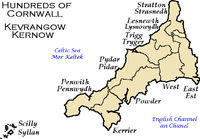
- Hundreds of CornwallHundreds of CornwallCornwall was from Anglo-Saxon times until the 19th century divided into hundreds, some with the suffix shire as in Pydarshire, East and West Wivelshire and Powdershire which were first recorded as names between 1184-1187. In the Cornish language the word for "hundred" is keverang and is the...
- Cornish peopleCornish peopleThe Cornish are a people associated with Cornwall, a county and Duchy in the south-west of the United Kingdom that is seen in some respects as distinct from England, having more in common with the other Celtic parts of the United Kingdom such as Wales, as well as with other Celtic nations in Europe...
- List of topics related to Cornwall
- History of CornwallHistory of CornwallThe history of Cornwall begins with the pre-Roman inhabitants, including speakers of a Celtic language that would develop into Brythonic and Cornish. Cornwall was part of the territory of the tribe of the Dumnonii. After a period of Roman rule, Cornwall reverted to rule by independent...
- The Wikipedia Cornwall Portal
- Maps of the UK and IrelandMaps of the UK and IrelandMaps of the UK and Ireland are available in various media.-Maps on CD ROM:ISYS OUTDOORS, Anquet Maps and Fugawi offer a series of 1:25,000, 1:50,000 and 1:250,000 scale UK Ordnance Survey maps including agazetteer of place names...
External links