
Manning River
Encyclopedia
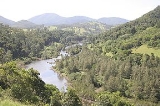
The Manning River is a river in the Mid North Coast of New South Wales
, Australia
that flows through the Manning Valley. It is one of Australia's few large river systems not to be dammed for water supply purposes anywhere along its catchment. The local water supply is fed by Bootawa Dam, which is an offsite dam, however, water is pumped from the river to the dam whenever river turbidity and flow levels can allow.
A small weir
exists on the upper most section of the Barnard River and is the Barnard River Scheme
for Bayswater Power Station the scheme is shutdown until needed but as of 2006 this Scheme was partly decommissioned due to its rare use.
The lower part of the river is a delta
system where it meets the sea, with several channels dividing coastal land into large islands, such as Mitchells
and Oxley Islands.
crossed and named Harrington and Farquhar inlets during a trip from the Hastings River
, near Port Macquaire
, to Port Stephens
. The Manning River itself was first surveyed by Henry Dangar
in 1825 and again in 1826 on behalf of the Australian Agricultural Company
. The river was recorded on the survey map as "Boolumbahtee," its Aboriginal name.
Later in 1826, the river was named Mannings River for the Deputy Governor of the Australian Agricultural Company
, Sir William Manning
. In the same year it was declared that the Manning was the northern limit of the Nineteen Counties
, defining the areas of New South Wales where settlers were free to occupy.
Until 1913, ships servicing the coast brought goods and supplies up the river.
 The Manning River is fed by the Avon River, Rowley's River, the Nowendoc River
, the Barnard River
, the Little Manning River, and the Barrington River
, which flows through Gloucester
. Once the river reaches Taree
it splits and the southern arm flows into the Pacific Ocean
at Old Bar. The northern arm is joined by the Dawson River
and the Landsdowne River and meets the ocean at Harrington
Hence the river has two separate entrances (or mouths).
Wingham
was established at the furthest point supply boats could reach up the river and became the regions major port. The old cargo wharf at Wingham Brush has been recently refurbished. The town of Tinonee
was also settled on the river near Taree.
The Manning River is the only double delta river in the southern Hemisphere and the only permanent multiple entrance river in the world other than the Nile River Egypt. The Manning is one of only a few Australian mainland rivers to receive annual winter melting snow deposits. These deposits flow from its tributary the Barrington River in Barrington Tops Mountains into the Manning.
(Platycephalus fuscus), a common Australian estuary fish. The Manning River is frequented by dolphins and sharks, with some venturing as far up the river to Wingham.
Whales also frequent the river, mainly at the larger Harrington inlet, although some do enter the Farquar inlet and generally do not venture far up river. However, on 16 September 1994 a rare tropical Bryde's whale
measuring 9 metres (29.5 ft) long, nicknamed "Free Willy" by locals, ventured much further up river to Taree where the river is freshwater. After becoming a tourist attraction, and repeatedly evading attempts by conservationists to free him "Free Willy" finally left the Manning River 92 days later of his own free will.
, and sailing
. The Taree Powerboat Club Spectacular is held in the Manning River during the Easter
long weekend. The link between Taree and the oyster
industry is shown by the presence in Taree of the "Big Oyster", a building constructed in the shape of an open oyster shell.
Commercial fishing and oyster farming are both practiced in the Manning. The peak season for oyster production is September to March and average yearly production is 310,755 dozen.
New South Wales
New South Wales is a state of :Australia, located in the east of the country. It is bordered by Queensland, Victoria and South Australia to the north, south and west respectively. To the east, the state is bordered by the Tasman Sea, which forms part of the Pacific Ocean. New South Wales...
, Australia
Australia
Australia , officially the Commonwealth of Australia, is a country in the Southern Hemisphere comprising the mainland of the Australian continent, the island of Tasmania, and numerous smaller islands in the Indian and Pacific Oceans. It is the world's sixth-largest country by total area...
that flows through the Manning Valley. It is one of Australia's few large river systems not to be dammed for water supply purposes anywhere along its catchment. The local water supply is fed by Bootawa Dam, which is an offsite dam, however, water is pumped from the river to the dam whenever river turbidity and flow levels can allow.
A small weir
Weir
A weir is a small overflow dam used to alter the flow characteristics of a river or stream. In most cases weirs take the form of a barrier across the river that causes water to pool behind the structure , but allows water to flow over the top...
exists on the upper most section of the Barnard River and is the Barnard River Scheme
Barnard River Scheme
The Barnard River Scheme is an inter-basin water transfer system in New South Wales, which can transfer water from the Barnard River in the upper Manning River catchment over the Mount Royal Range into the Hunter River....
for Bayswater Power Station the scheme is shutdown until needed but as of 2006 this Scheme was partly decommissioned due to its rare use.
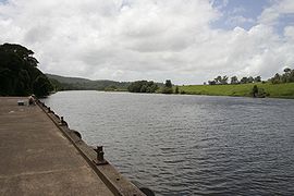
The lower part of the river is a delta
River delta
A delta is a landform that is formed at the mouth of a river where that river flows into an ocean, sea, estuary, lake, reservoir, flat arid area, or another river. Deltas are formed from the deposition of the sediment carried by the river as the flow leaves the mouth of the river...
system where it meets the sea, with several channels dividing coastal land into large islands, such as Mitchells
Mitchells Island
Mitchells Island is the largest of several islands in the mouth of the Manning River. It is roughly triangular in shape and has an area of approximately . It is bordered on the north by the main channel of the Manning River, on the southwest by Scotts Creek, and on the east by the Pacific Ocean...
and Oxley Islands.
History
In 1818, John OxleyJohn Oxley
John Joseph William Molesworth Oxley was an explorer and surveyor of Australia in the early period of English colonisation.October 1802 he was engaged in coastal survey work including an expedition to Western Port in 1804-05...
crossed and named Harrington and Farquhar inlets during a trip from the Hastings River
Hastings River
The Hastings River is a large river on the Mid North Coast of the Australian state of New South Wales that empties into the Tasman Sea, a branch of the South Pacific Ocean, at Port Macquarie....
, near Port Macquaire
Port Macquarie, New South Wales
Port Macquarie is a city on the Mid North Coast of New South Wales, Australia, located about north of Sydney, and south of Brisbane. The city is located on the coast, at the mouth of the Hastings River, and has an estimated population of 44,313....
, to Port Stephens
Port Stephens
Port Stephens is a large natural harbour located about north-east of Sydney in New South Wales, Australia. It lies wholly within the Port Stephens Local Government Area although its northern shoreline forms the boundary between the Port Stephens and Great Lakes LGAs...
. The Manning River itself was first surveyed by Henry Dangar
Henry Dangar
Henry Dangar was a surveyor and explorer of Australia in the early period of British colonisation. He became a successful pastoralist and businessman, and also served as a magistrate and politician...
in 1825 and again in 1826 on behalf of the Australian Agricultural Company
Australian Agricultural Company
The Australian Agricultural Company is a company which serves to improve beef cattle production through responsible natural resource and land use...
. The river was recorded on the survey map as "Boolumbahtee," its Aboriginal name.
Later in 1826, the river was named Mannings River for the Deputy Governor of the Australian Agricultural Company
Australian Agricultural Company
The Australian Agricultural Company is a company which serves to improve beef cattle production through responsible natural resource and land use...
, Sir William Manning
William Manning
William Manning was a British merchant, politician, and Governor of the Bank of England between 1812 and 1814....
. In the same year it was declared that the Manning was the northern limit of the Nineteen Counties
Nineteen Counties
The Nineteen Counties were the limits of location in the colony of New South Wales defined by the Governor of New South Wales Sir Ralph Darling in 1826 in accordance with a government order from Lord Bathurst, the secretary of State. Counties had been used since the first year of settlement, with...
, defining the areas of New South Wales where settlers were free to occupy.
Until 1913, ships servicing the coast brought goods and supplies up the river.
Geography
Nowendoc River
The Nowendoc River is on the Northern Tablelands of New South Wales, Australia. The headwaters of the river rise about four kilometres east by north of The Black Sugarloaf on the eastern slopes of the Great Dividing Range south of Walcha...
, the Barnard River
Barnard River
-References:...
, the Little Manning River, and the Barrington River
Barrington River
The Barrington River is a tidal extension of Runnins River in the U.S. state of Rhode Island and Massachusetts. It flows approximately 6 km . There are no dams along the river's length.-History:...
, which flows through Gloucester
Gloucester, New South Wales
Gloucester is a town in the dairy and beef cattle country of the Manning district on the Mid North Coast of the state of New South Wales, Australia in the Gloucester Shire....
. Once the river reaches Taree
Taree, New South Wales
Taree is a city on the Mid North Coast, New South Wales, Australia. Taree and nearby Cundletown were settled in 1831 by William Wynter. Since then Taree has grown to a population of around 20,000 people and is the centre of a significant agricultural district. It is 16 km from the sea coast,...
it splits and the southern arm flows into the Pacific Ocean
Pacific Ocean
The Pacific Ocean is the largest of the Earth's oceanic divisions. It extends from the Arctic in the north to the Southern Ocean in the south, bounded by Asia and Australia in the west, and the Americas in the east.At 165.2 million square kilometres in area, this largest division of the World...
at Old Bar. The northern arm is joined by the Dawson River
Dawson River (New South Wales)
Dawson River is a river in the Mid North Coast region of New South Wales, Australia. The river is a tributary of the Manning River, which it meets downstream of Taree.- External links :*...
and the Landsdowne River and meets the ocean at Harrington
Harrington, New South Wales
Harrington is a small fishing village located at the mouth of the Manning River in New South Wales, Australia . It is north-east of Taree on the Mid North Coast, and north east of the state capital, Sydney...
Hence the river has two separate entrances (or mouths).
Wingham
Wingham, New South Wales
Wingham is a town in the Mid North Coast region of New South Wales, Australia in the City of Greater Taree north of Sydney. At the 2006 census, Wingham had a population of 4,812.- History :...
was established at the furthest point supply boats could reach up the river and became the regions major port. The old cargo wharf at Wingham Brush has been recently refurbished. The town of Tinonee
Tinonee, New South Wales
Tinonee is a small town on the banks of the Manning River, near Taree on the Mid North Coast of New South Wales in the City of Greater Taree, Australia. Tinonee was founded in 1854 and in the late 1980s became part of Greater Taree City...
was also settled on the river near Taree.
The Manning River is the only double delta river in the southern Hemisphere and the only permanent multiple entrance river in the world other than the Nile River Egypt. The Manning is one of only a few Australian mainland rivers to receive annual winter melting snow deposits. These deposits flow from its tributary the Barrington River in Barrington Tops Mountains into the Manning.
Ecology
The Manning River is a large producer of Australian oysters and is home to many fish, the most common being the Dusky FlatheadDusky Flathead
The dusky flathead is a large predatory fish and the largest member of the Platycephalidae family...
(Platycephalus fuscus), a common Australian estuary fish. The Manning River is frequented by dolphins and sharks, with some venturing as far up the river to Wingham.
Whales also frequent the river, mainly at the larger Harrington inlet, although some do enter the Farquar inlet and generally do not venture far up river. However, on 16 September 1994 a rare tropical Bryde's whale
Bryde's Whale
Bryde's whales are baleen whales, one of the "great whales" or rorquals. They prefer tropical and temperate waters over the polar seas that other whales in their family frequent. They are largely coastal rather than pelagic. Bryde's whales are very similar in appearance to sei whales and almost as...
measuring 9 metres (29.5 ft) long, nicknamed "Free Willy" by locals, ventured much further up river to Taree where the river is freshwater. After becoming a tourist attraction, and repeatedly evading attempts by conservationists to free him "Free Willy" finally left the Manning River 92 days later of his own free will.
Events
Taree is home to the annual Manning River Summer Festival, which features rowingWatercraft rowing
Watercraft rowing is the act of propelling a boat using the motion of oars in the water. The difference between paddling and rowing is that with rowing the oars have a mechanical connection with the boat whereas with paddling the paddles are hand-held with no mechanical connection.This article...
, and sailing
Sailing
Sailing is the propulsion of a vehicle and the control of its movement with large foils called sails. By changing the rigging, rudder, and sometimes the keel or centre board, a sailor manages the force of the wind on the sails in order to move the boat relative to its surrounding medium and...
. The Taree Powerboat Club Spectacular is held in the Manning River during the Easter
Easter
Easter is the central feast in the Christian liturgical year. According to the Canonical gospels, Jesus rose from the dead on the third day after his crucifixion. His resurrection is celebrated on Easter Day or Easter Sunday...
long weekend. The link between Taree and the oyster
Oyster
The word oyster is used as a common name for a number of distinct groups of bivalve molluscs which live in marine or brackish habitats. The valves are highly calcified....
industry is shown by the presence in Taree of the "Big Oyster", a building constructed in the shape of an open oyster shell.
Industry
Tourist trips are popular on the Manning.Commercial fishing and oyster farming are both practiced in the Manning. The peak season for oyster production is September to March and average yearly production is 310,755 dozen.
See also
- List of rivers of Australia
- Rivers of New South WalesRivers of New South WalesThis page discusses the rivers and hydrography of the State of New South Wales, Australia.The principal topographic feature of New South Wales is the series of low highlands and plateaus called the Great Dividing Range, which extend from north to south roughly parallel to the coast of the Tasman...
- Mitchells IslandMitchells IslandMitchells Island is the largest of several islands in the mouth of the Manning River. It is roughly triangular in shape and has an area of approximately . It is bordered on the north by the main channel of the Manning River, on the southwest by Scotts Creek, and on the east by the Pacific Ocean...