
.gif)
M Street (Washington, D.C.)
Encyclopedia
The name "M Street" refers to two major roads in the United States
capital of Washington, D.C.
Because of the Cartesian-coordinate-based
street-naming
system in Washington, the name M Street can be used to refer to any east-west street located twelve blocks north or south of the dome of the United States Capitol
(not thirteen blocks, as there is no J Street). Thus, in all four quadrants
of the city there are streets called "M Street", which are disambiguated by quadrant designations, namely, M Street NW NE, SW, and SE.
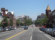
 In Northwest Washington, M Street is a major street downtown and the main east-west street in the Georgetown
neighborhood.
M Street NW begins at the Key Bridge, which crosses the Potomac River
at the 3500 block. To the west of 36th Street, M Street turns into Canal Road. M Street was originally called Bridge Street until the roads in Georgetown were renamed in 1895
to conform to the street name
s used in Pierre Charles L’Enfant's original plan for the federal city. Where 32nd Street would otherwise be, M Street intersects with Wisconsin Avenue
. At 29th Street, it meets the western terminus of Pennsylvania Avenue
. This is the last major intersection before Rock Creek
, which forms the eastern border of Georgetown. The section in Georgetown carries heavy commuter traffic because it connects Pennsylvania Avenue with the Key Bridge and Canal Road.
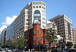
 From Pennsylvania Avenue to Thomas Circle at 14th Street
, M Street is designated for one-way traffic
with vehicles driving westbound-only. M Street once again becomes two-way in Georgetown. This stretch is highly developed, consisting mainly of apartments from 26th to 21st and businesses from 21st to Thomas Circle.
From 14th Street to 5th Street NW, M Street is again two-way. Between 9th and 7th Streets
NW, it passes underneath the Walter E. Washington Convention Center. From 5th Street to North Capitol Street
, it assumes a complex traffic pattern because of the intersections and near-intersections of several high-traffic streets: M, New York Ave
/U.S. Route 50
, the northern terminus of Interstate 395
, New Jersey Avenue, and North Capitol Street. Traffic is west-to-east from 5th to 4th, east-to-west from New York to 4th, and west-to-east from New York through North Capitol and onto M Street NE.
between 6th and 7th, where it terminates at the gates of Gallaudet University
. Along the way, it uses an overpass to avoid the Union Station
rail yard
.
Because the intervening Trinidad
neighborhood does not follow the grid pattern, M Street does not emerge again until Bladensburg Road (between 16th and 17th). This two-way stretch dead-ends after intersecting with Maryland Avenue (where 26th Street would be), because the remaining land between that intersection and the Anacostia River
is occupied by the United States National Arboretum
and Langston Golf Course
. The portion of Washington across the Anacostia follows its own variant of the grid pattern, so while there is no M Street NE, the Deanwood neighborhood of Anacostia does have a Meade Street NE in the location where M Street would have re-emerged.
 About a mile south of the U.S. Capitol, M Street is a major east-west traffic thoroughfare connecting Maine Avenue
with Interstate 295
. The Potomac River prevents M Street from extending farther west than 6th Street/Maine Avenue. Likewise, the Anacostia River limits M Street SE east of 11th to being a named on-ramp for I-295 (the 11th Street Bridges
to the immediate south and the Southeast Freeway
to the immediate north), Water Street SE (home of several boating clubs), and Pennsylvania Avenue SE at the John Philip Sousa Bridge
before terminating.
The most prominent intersection on M Street between those points is with South Capitol Street. M Street runs along the northern edge of the Washington Navy Yard
(between 1st and 11th) and near Nationals Park, between 1st and South Capitol.
The Anacostia neighborhood, across the river, has its own M Street SE. Beginning at the Anacostia Freeway
(DC-295, roughly where 29th Street would be), it runs diagonally two blocks, merges with Anacostia Road for one block, then straightens out for two blocks before terminating at 34th Street SE. Its route is blocked by Massachusetts Avenue
SE and Fort Dupont Park
.
United States
The United States of America is a federal constitutional republic comprising fifty states and a federal district...
capital of Washington, D.C.
Washington, D.C.
Washington, D.C., formally the District of Columbia and commonly referred to as Washington, "the District", or simply D.C., is the capital of the United States. On July 16, 1790, the United States Congress approved the creation of a permanent national capital as permitted by the U.S. Constitution....
Because of the Cartesian-coordinate-based
Cartesian coordinate system
A Cartesian coordinate system specifies each point uniquely in a plane by a pair of numerical coordinates, which are the signed distances from the point to two fixed perpendicular directed lines, measured in the same unit of length...
street-naming
Street name
A street name or odonym is an identifying name given to a street. The street name usually forms part of the address...
system in Washington, the name M Street can be used to refer to any east-west street located twelve blocks north or south of the dome of the United States Capitol
United States Capitol
The United States Capitol is the meeting place of the United States Congress, the legislature of the federal government of the United States. Located in Washington, D.C., it sits atop Capitol Hill at the eastern end of the National Mall...
(not thirteen blocks, as there is no J Street). Thus, in all four quadrants
Quadrants of Washington, D.C.
Washington, D.C., is administratively divided into four geographical quadrants of unequal size, each delineated by their ordinal directions from the medallion located in the Crypt under the Rotunda of the Capitol...
of the city there are streets called "M Street", which are disambiguated by quadrant designations, namely, M Street NW NE, SW, and SE.
M Street NW
Georgetown, Washington, D.C.
Georgetown is a neighborhood located in northwest Washington, D.C., situated along the Potomac River. Founded in 1751, the port of Georgetown predated the establishment of the federal district and the City of Washington by 40 years...
neighborhood.
M Street NW begins at the Key Bridge, which crosses the Potomac River
Potomac River
The Potomac River flows into the Chesapeake Bay, located along the mid-Atlantic coast of the United States. The river is approximately long, with a drainage area of about 14,700 square miles...
at the 3500 block. To the west of 36th Street, M Street turns into Canal Road. M Street was originally called Bridge Street until the roads in Georgetown were renamed in 1895
Georgetown street renaming
The Georgetown street renaming occurred as a result of an 1895 act of the United States Congress that ended even the nominal independence of Georgetown from Washington, D.C. The Act required, inter alia, that the street names in Georgetown be changed to conform to the street naming system in use...
to conform to the street name
Street name
A street name or odonym is an identifying name given to a street. The street name usually forms part of the address...
s used in Pierre Charles L’Enfant's original plan for the federal city. Where 32nd Street would otherwise be, M Street intersects with Wisconsin Avenue
Wisconsin Avenue (Washington, D.C.)
Wisconsin Avenue is a major thoroughfare in Washington, D.C., and its Maryland suburbs. It starts in Georgetown just north of the Potomac River, at an intersection with K Street under the Whitehurst Freeway...
. At 29th Street, it meets the western terminus of Pennsylvania Avenue
Pennsylvania Avenue
Pennsylvania Avenue is a street in Washington, D.C. that joins the White House and the United States Capitol. Called "America's Main Street", it is the location of official parades and processions, as well as protest marches...
. This is the last major intersection before Rock Creek
Rock Creek (Potomac River)
Rock Creek is a free-flowing tributary of the Potomac River, which empties into the Atlantic Ocean via the Chesapeake Bay. The creek is long, with a drainage area of about...
, which forms the eastern border of Georgetown. The section in Georgetown carries heavy commuter traffic because it connects Pennsylvania Avenue with the Key Bridge and Canal Road.
14th Street Northwest and Southwest (Washington, D.C.)
Fourteenth Street is a street in Northwest and Southwest Washington, D.C., located 1¼ mi. west of the U.S. Capitol. It runs from the 14th Street Bridge north to Eastern Avenue....
, M Street is designated for one-way traffic
One-way traffic
One-way traffic is traffic that moves in a single direction. A one-way street is a street either facilitating only one-way traffic, or designed to direct vehicles to move in one direction.-General signs:...
with vehicles driving westbound-only. M Street once again becomes two-way in Georgetown. This stretch is highly developed, consisting mainly of apartments from 26th to 21st and businesses from 21st to Thomas Circle.
From 14th Street to 5th Street NW, M Street is again two-way. Between 9th and 7th Streets
7th Street (Washington, D.C.)
There are four north-south arteries in Washington, D.C. named Seventh Street that are differentiated by the quadrants of the city in which they are located. Historically, 7th Street has been a main north-south road in Washington, being the main route for travelers and farmers coming into the city...
NW, it passes underneath the Walter E. Washington Convention Center. From 5th Street to North Capitol Street
North Capitol Street
North Capitol Street is a street in Washington, D.C. that separates the Northwest and Northeast quadrants of the city. The street begins at D Street due north of the United States Capitol and continues northward 4½ miles to Nicholson Street where it is interrupted by Fort Slocum Park and the...
, it assumes a complex traffic pattern because of the intersections and near-intersections of several high-traffic streets: M, New York Ave
New York Avenue (Washington, D.C.)
New York Avenue is one of the diagonal avenues radiating from the White House in Washington, D.C. It is a major east-west route in the city's Northwest and Northeast quadrants and connects downtown with points east and north of the city via Cheverly, Maryland, the John Hanson Highway and the...
/U.S. Route 50
U.S. Route 50
U.S. Route 50 is a major east–west route of the U.S. Highway system, stretching just over from Ocean City, Maryland on the Atlantic Ocean to West Sacramento, California. Until 1972, when it was replaced by Interstate Highways west of the Sacramento area, it extended to San Francisco, near...
, the northern terminus of Interstate 395
Interstate 395 (District of Columbia-Virginia)
Interstate 395 in Washington, D.C., and Virginia is a 13 mile long spur route that begins at a junction with Interstate 95 in Springfield, Virginia and ends in northwest Washington, D.C. It passes underneath the National Mall near the United States Capitol and ends at a junction with U.S...
, New Jersey Avenue, and North Capitol Street. Traffic is west-to-east from 5th to 4th, east-to-west from New York to 4th, and west-to-east from New York through North Capitol and onto M Street NE.
M Street NE
M Street NE runs west-to-east from North Capitol Street to Florida AvenueFlorida Avenue (Washington, D.C.)
Florida Avenue is a major street in Washington, D.C. It was originally named Boundary Street, because it formed the northern boundary of Pierre L'Enfant's original plan for the Federal City...
between 6th and 7th, where it terminates at the gates of Gallaudet University
Gallaudet University
Gallaudet University is a federally-chartered university for the education of the deaf and hard of hearing, located in the District of Columbia, U.S...
. Along the way, it uses an overpass to avoid the Union Station
Union Station (Washington, D.C.)
Washington Union Station is a train station and leisure destination visited by 32 million people each year in the center of Washington, D.C. The train station is served by Amtrak, MARC and Virginia Railway Express commuter rail services as well as by Washington Metro subway trains and local buses...
rail yard
Rail yard
A rail yard, or railroad yard, is a complex series of railroad tracks for storing, sorting, or loading/unloading, railroad cars and/or locomotives. Railroad yards have many tracks in parallel for keeping rolling stock stored off the mainline, so that they do not obstruct the flow of traffic....
.
Because the intervening Trinidad
Trinidad, Washington, D.C.
Trinidad is a neighborhood located in Ward 5, in the northeast quadrant of Washington, D.C. and is a largely residential area.-Geography:Trinidad is bounded to the north by Mt. Olivet Road, to the west by West Virginia Avenue, to the south by Florida Avenue, and to the east by Bladensburg Road. To...
neighborhood does not follow the grid pattern, M Street does not emerge again until Bladensburg Road (between 16th and 17th). This two-way stretch dead-ends after intersecting with Maryland Avenue (where 26th Street would be), because the remaining land between that intersection and the Anacostia River
Anacostia River
The Anacostia River is a river in the Mid Atlantic region of the United States. It flows from Prince George's County in Maryland into Washington, D.C., where it joins with the Washington Channel to empty into the Potomac River at Buzzard Point. It is approximately long...
is occupied by the United States National Arboretum
United States National Arboretum
The United States National Arboretum is an arboretum in Washington, D.C., operated by the United States Department of Agriculture's Agricultural Research Service as a division of the Henry A. Wallace Beltsville Agricultural Research Center...
and Langston Golf Course
Langston Golf Course
Langston Golf Course is an 18-hole golf course in Washington, D.C., established in 1939. It was named for John Mercer Langston, an African American who was the first dean of the Howard University School of Law, the first president of Virginia Normal and Collegiate Institute , and the first African...
. The portion of Washington across the Anacostia follows its own variant of the grid pattern, so while there is no M Street NE, the Deanwood neighborhood of Anacostia does have a Meade Street NE in the location where M Street would have re-emerged.
M Street SW/SE
Maine Avenue (Washington, D.C.)
Maine Avenue is a diagonal avenue in the Southwest quadrant of Washington, D.C.. Maine Avenue connects Independence Avenue with M Street SW, and has an interchange with Interstate 395.-Route:...
with Interstate 295
Interstate 295 (District of Columbia)
Interstate 295 in the U.S. state of Maryland and in Washington, D.C. is a spur route connecting I-95/I-495 and Maryland Route 210 on the Potomac River to Interstate 695 in downtown Washington.-Route description:Although I-295 technically begins at the Capital Beltway , a pair of mainline...
. The Potomac River prevents M Street from extending farther west than 6th Street/Maine Avenue. Likewise, the Anacostia River limits M Street SE east of 11th to being a named on-ramp for I-295 (the 11th Street Bridges
11th Street Bridges
The 11th Street Bridges are a pair of one-way bridges across the Anacostia River in Washington, D.C., U.S.A. The southbound structure is officially named the Officer Kevin J. Welsh Memorial Bridge, while the northbound structure is officially named the 11th Street Bridge. The bridges convey...
to the immediate south and the Southeast Freeway
Interstate 695 (District of Columbia)
Interstate 695 is the unsigned designation for the 1.39-mile Southeast Freeway in Washington, D.C. It runs from Interstate 395 south of the United States Capitol building east past the north end of Interstate 295 to Pennsylvania Avenue at Barney Circle, just northwest of the John Philip Sousa...
to the immediate north), Water Street SE (home of several boating clubs), and Pennsylvania Avenue SE at the John Philip Sousa Bridge
John Philip Sousa Bridge
The John Philip Sousa Bridge is a bridge that carries Pennsylvania Avenue across the Anacostia River in Washington, D.C., U.S.A. It has partial interchanges with unsigned Interstate 695 at its western terminus and with District of Columbia Route 295 at its eastern terminus.The first bridge at that...
before terminating.
The most prominent intersection on M Street between those points is with South Capitol Street. M Street runs along the northern edge of the Washington Navy Yard
Washington Navy Yard
The Washington Navy Yard is the former shipyard and ordnance plant of the United States Navy in Southeast Washington, D.C. It is the oldest shore establishment of the U.S. Navy...
(between 1st and 11th) and near Nationals Park, between 1st and South Capitol.
The Anacostia neighborhood, across the river, has its own M Street SE. Beginning at the Anacostia Freeway
Interstate 295 (District of Columbia)
Interstate 295 in the U.S. state of Maryland and in Washington, D.C. is a spur route connecting I-95/I-495 and Maryland Route 210 on the Potomac River to Interstate 695 in downtown Washington.-Route description:Although I-295 technically begins at the Capital Beltway , a pair of mainline...
(DC-295, roughly where 29th Street would be), it runs diagonally two blocks, merges with Anacostia Road for one block, then straightens out for two blocks before terminating at 34th Street SE. Its route is blocked by Massachusetts Avenue
Massachusetts Avenue (Washington, D.C.)
Massachusetts Avenue is a major diagonal transverse road in Washington, D.C., and the Massachusetts Avenue Historic District is a historic district that includes part of it....
SE and Fort Dupont Park
Fort Dupont Park
Fort Dupont Park, located in Washington, DC, is a wooded park under the management of the National Park Service. The name of the park comes from the old Civil War earthwork fort that lies within the park...
.