
.gif)
Massachusetts Avenue (Washington, D.C.)
Encyclopedia
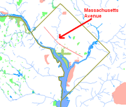
Massachusetts Avenue is a major diagonal transverse road in Washington, D.C.
, and the Massachusetts Avenue Historic District is a historic district
that includes part of it.
Appearing in Peter Charles L'Enfant
's original plan, Massachusetts Avenue is the longest thoroughfare in the capital, crossing three of its four quadrants. It intersects every major north–south street and passes numerous Washington landmarks. It is a landmark itself, long considered the northern boundary of the downtown
as well as home of Washington's Embassy Row
.
Massachusetts Avenue is tied with Pennsylvania Avenue
as the widest road in the District, at 160 ft (50 m). The two roads run in parallel through much of the city, Massachusetts about seven blocks north of Pennsylvania. Massachusetts Avenue was long Washington's premier residential street, as Pennsylvania was once its most sought-after business address. Both streets were named after states with prominent roles in the American Revolution
.
The historic district is an 81 acres (32.8 ha) area that includes 150 contributing buildings and 3 contributing structures. It was listed on the National Register of Historic Places
in 1985. It includes multiple properties that are individually listed on the National Register.
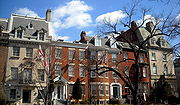 Residential development along Massachusetts Avenue accelerated in the 1870s, mostly around the circles located west of 9th Street NW. These brick
and brownstone
structures reflected the Queen Anne, Richardsonian Romanesque
, and Château
styles in vogue at the time. Later, luxurious Georgian Revival
and Beaux-Arts mansions inhabited by wealthy and influential Washingtonians sprouted along the boulevard. The section between Sheridan Circle
and Scott Circle
became known as "Millionaires' Row".
The Great Depression
forced many to relinquish their homes on Millionaires' Row. After World War II
, Massachusetts Avenue was seen as less fashionable than newer areas such as upper 16th Street
. Many residences were sold and demolished to make way for office buildings, particularly around Dupont Circle and to its east. Many others, however, survived as embassies and society houses; the former Millionaires' Row is today well known as Embassy Row
.
Several overlapping historic districts have been created to preserve the character of the remaining neighborhoods. The Massachusetts Avenue Historic District encompasses all buildings which front the road between 17th Street and Observatory Circle
NW.
 The main section of Massachusetts Avenue begins at 19th Street Southeast, just to the west of the former D.C. General Hospital site and one block north of Congressional Cemetery
. At elevation with respect to the hospital, Massachusetts Avenue commands a view of the Anacostia River
. It proceeds in a northwesterly direction crosstown. At Lincoln Park the road enters Northeast D.C. and the neighborhood of Capitol Hill. After briefly converging with Columbus Circle
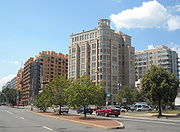
as it curves around Union Station, Massachusetts enters Northwest D.C. in a rapidly-changing neighborhood which has transitioned from earlier blight and decay to in the 21st Century developing numerous high-rise apartment complexes. In the tradition of the acronym Soho
, realtors sometimes give this area the moniker "NOMA" (North of Massachusetts Avenue).
It intersects with Interstate 395 (which runs underground at that point) at H Street NW, and passes over Mount Vernon Square
in front of the Walter E. Washington Convention Center. Continuing northwest, Massachusetts enters an underpass below Thomas Circle
at 14th
and M Streets
NW, before curving around Scott Circle
at 16th
and N Streets NW; this is considered the starting point of Embassy Row
.
 Massachusetts Avenue passes through the inner ring of Dupont Circle
and curves north at Sheridan Circle
, paralleling Rock Creek
to Belmont Road NW. On the other side, it curves around the United States Naval Observatory
and Number One Observatory Circle
, the official residence
of the Vice President of the United States
, which forms the southwest boundary of the Massachusetts Heights
neighborhood. The Washington National Cathedral
, located at the intersection of Mass and Wisconsin Avenues, is usually considered the end of Embassy Row.
At Ward Circle
, Massachusetts delineates the American University Park
neighborhood from Spring Valley
, passing to the north of American University
. It crosses the Washington-Montgomery County
, Maryland
border at Westmoreland Circle
. In Maryland, the road continues signed as State Highway 396, meandering through residential sections of Bethesda
until terminating at Goldsboro Road (Maryland State Highway 614).
 Another section of Massachusetts Avenue, discontinuous from the one described above, lies on the east side of the Anacostia River. That section extends from 30th Street SE near District of Columbia Route 295
, to Southern Avenue SE at the border between D.C. and Prince George's County
.
Other notable institutions located on Massachusetts Avenue include the Postal Square Building
(which houses the Bureau of Labor Statistics
and the National Postal Museum
), the Heritage Foundation
, Georgetown University Law Center
, the Islamic Center of Washington
, the Cato Institute
, National Public Radio, the Paul H. Nitze School of Advanced International Studies
, the Brookings Institution
, the Peterson Institute, St. Nicholas Cathedral, and the Carnegie Endowment for International Peace
. Numerous embassies and residences are listed on the National Register of Historic Places
, and the National Trust for Historic Preservation
makes its home on Massachusetts Avenue.
lines run along Massachusetts Avenue, the Metrobus
N routes serve upper Northwest while a patchwork of routes serve Downtown, Northeast, and Southeast.
travels along the street:
Route 29 serves Massachusetts Avenue in Maryland from Westmoreland Circle to the avenue's terminus at Goldsboro Road.
The M6 (which travels from the Potomac Avenue Metro station to Fairfax Village) runs along Massachusetts Avenue between Alabama Avenue and Southern Avenue.
stations have stops located near Massachusetts Avenue:
lies on Massachusetts Avenue at Columbus Circle, and it is served by Amtrak
, MARC
, and Virginia Railway Express
trains.
Washington, D.C.
Washington, D.C., formally the District of Columbia and commonly referred to as Washington, "the District", or simply D.C., is the capital of the United States. On July 16, 1790, the United States Congress approved the creation of a permanent national capital as permitted by the U.S. Constitution....
, and the Massachusetts Avenue Historic District is a historic district
Historic district (United States)
In the United States, a historic district is a group of buildings, properties, or sites that have been designated by one of several entities on different levels as historically or architecturally significant. Buildings, structures, objects and sites within a historic district are normally divided...
that includes part of it.
Appearing in Peter Charles L'Enfant
Pierre Charles L'Enfant
Pierre Charles L'Enfant was a French-born American architect and civil engineer best known for designing the layout of the streets of Washington, D.C..-Early life:...
's original plan, Massachusetts Avenue is the longest thoroughfare in the capital, crossing three of its four quadrants. It intersects every major north–south street and passes numerous Washington landmarks. It is a landmark itself, long considered the northern boundary of the downtown
Downtown
Downtown is a term primarily used in North America by English speakers to refer to a city's core or central business district ....
as well as home of Washington's Embassy Row
Embassy Row
Embassy Row is the informal name for a street or area of a city in which embassies or other diplomatic installations are concentrated. Washington, D.C.'s Embassy Row lies along Massachusetts Avenue, N.W., and its cross streets between Thomas Circle and Ward Circle, although the vast majority of...
.
Massachusetts Avenue is tied with Pennsylvania Avenue
Pennsylvania Avenue
Pennsylvania Avenue is a street in Washington, D.C. that joins the White House and the United States Capitol. Called "America's Main Street", it is the location of official parades and processions, as well as protest marches...
as the widest road in the District, at 160 ft (50 m). The two roads run in parallel through much of the city, Massachusetts about seven blocks north of Pennsylvania. Massachusetts Avenue was long Washington's premier residential street, as Pennsylvania was once its most sought-after business address. Both streets were named after states with prominent roles in the American Revolution
American Revolution
The American Revolution was the political upheaval during the last half of the 18th century in which thirteen colonies in North America joined together to break free from the British Empire, combining to become the United States of America...
.
The historic district is an 81 acres (32.8 ha) area that includes 150 contributing buildings and 3 contributing structures. It was listed on the National Register of Historic Places
National Register of Historic Places
The National Register of Historic Places is the United States government's official list of districts, sites, buildings, structures, and objects deemed worthy of preservation...
in 1985. It includes multiple properties that are individually listed on the National Register.
History
Brick
A brick is a block of ceramic material used in masonry construction, usually laid using various kinds of mortar. It has been regarded as one of the longest lasting and strongest building materials used throughout history.-History:...
and brownstone
Brownstone
Brownstone is a brown Triassic or Jurassic sandstone which was once a popular building material. The term is also used in the United States to refer to a terraced house clad in this material.-Types:-Apostle Island brownstone:...
structures reflected the Queen Anne, Richardsonian Romanesque
Richardsonian Romanesque
Richardsonian Romanesque is a style of Romanesque Revival architecture named after architect Henry Hobson Richardson, whose masterpiece is Trinity Church, Boston , designated a National Historic Landmark...
, and Château
Château
A château is a manor house or residence of the lord of the manor or a country house of nobility or gentry, with or without fortifications, originally—and still most frequently—in French-speaking regions...
styles in vogue at the time. Later, luxurious Georgian Revival
Georgian architecture
Georgian architecture is the name given in most English-speaking countries to the set of architectural styles current between 1720 and 1840. It is eponymous for the first four British monarchs of the House of Hanover—George I of Great Britain, George II of Great Britain, George III of the United...
and Beaux-Arts mansions inhabited by wealthy and influential Washingtonians sprouted along the boulevard. The section between Sheridan Circle
Sheridan Circle
Sheridan Circle is a traffic circle in the Washington, D.C. neighborhood of Embassy Row. It is named for General Philip Sheridan, Union general of the American Civil War and later general of the United States Army...
and Scott Circle
Scott Circle
Scott Circle is a traffic circle in the northwest quadrant of Washington, D.C., at the junction of Massachusetts Avenue, Rhode Island Avenue, and 16th Street, N.W...
became known as "Millionaires' Row".
The Great Depression
Great Depression
The Great Depression was a severe worldwide economic depression in the decade preceding World War II. The timing of the Great Depression varied across nations, but in most countries it started in about 1929 and lasted until the late 1930s or early 1940s...
forced many to relinquish their homes on Millionaires' Row. After World War II
World War II
World War II, or the Second World War , was a global conflict lasting from 1939 to 1945, involving most of the world's nations—including all of the great powers—eventually forming two opposing military alliances: the Allies and the Axis...
, Massachusetts Avenue was seen as less fashionable than newer areas such as upper 16th Street
16th Street Northwest (Washington, D.C.)
16th Street Northwest is a prominent north-south thoroughfare in the northwest quadrant of Washington, D.C.Part of Pierre L'Enfant's design for the city, 16th Street begins just north of the White House across Lafayette Park at H Street and continues due north in a straight line passing K Street,...
. Many residences were sold and demolished to make way for office buildings, particularly around Dupont Circle and to its east. Many others, however, survived as embassies and society houses; the former Millionaires' Row is today well known as Embassy Row
Embassy Row
Embassy Row is the informal name for a street or area of a city in which embassies or other diplomatic installations are concentrated. Washington, D.C.'s Embassy Row lies along Massachusetts Avenue, N.W., and its cross streets between Thomas Circle and Ward Circle, although the vast majority of...
.
Several overlapping historic districts have been created to preserve the character of the remaining neighborhoods. The Massachusetts Avenue Historic District encompasses all buildings which front the road between 17th Street and Observatory Circle
Observatory Circle
Observatory Circle is a street in Washington, D.C. It runs from Calvert Street to Massachusetts Avenue near 34th Street. The street follows an incomplete loop, forming an arc rather than a circle...
NW.
Course
Congressional Cemetery
The Congressional Cemetery is a historic cemetery located at 1801 E Street, SE, in Washington, D.C., on the west bank of the Anacostia River. It is the final resting place of thousands of individuals who helped form the nation and the city of Washington in the early 19th century. Many members of...
. At elevation with respect to the hospital, Massachusetts Avenue commands a view of the Anacostia River
Anacostia River
The Anacostia River is a river in the Mid Atlantic region of the United States. It flows from Prince George's County in Maryland into Washington, D.C., where it joins with the Washington Channel to empty into the Potomac River at Buzzard Point. It is approximately long...
. It proceeds in a northwesterly direction crosstown. At Lincoln Park the road enters Northeast D.C. and the neighborhood of Capitol Hill. After briefly converging with Columbus Circle
Columbus Circle, Washington D.C.
Columbus Circle, also known as Union Station Plaza, is a traffic circle at the intersection of Delaware, Louisiana and Massachusetts Avenues and E and First Streets, Northeast in Washington, D.C....
as it curves around Union Station, Massachusetts enters Northwest D.C. in a rapidly-changing neighborhood which has transitioned from earlier blight and decay to in the 21st Century developing numerous high-rise apartment complexes. In the tradition of the acronym Soho
Soho
Soho is an area of the City of Westminster and part of the West End of London. Long established as an entertainment district, for much of the 20th century Soho had a reputation for sex shops as well as night life and film industry. Since the early 1980s, the area has undergone considerable...
, realtors sometimes give this area the moniker "NOMA" (North of Massachusetts Avenue).
It intersects with Interstate 395 (which runs underground at that point) at H Street NW, and passes over Mount Vernon Square
Mount Vernon Square
Mount Vernon Square is a city square in the Northwest quadrant of Washington, D.C. It is located where the following streets would otherwise intersect: Massachusetts Avenue, New York Avenue, K Street, and 8th Street NW....
in front of the Walter E. Washington Convention Center. Continuing northwest, Massachusetts enters an underpass below Thomas Circle
Thomas Circle
Thomas Circle is a traffic circle in Northwest Washington, D.C., United States at the junction of Massachusetts Avenue, Vermont Avenue, 14th Street, and M Street, N.W.The through lanes of Massachusetts Avenue pass under Thomas Circle...
at 14th
14th Street Northwest and Southwest (Washington, D.C.)
Fourteenth Street is a street in Northwest and Southwest Washington, D.C., located 1¼ mi. west of the U.S. Capitol. It runs from the 14th Street Bridge north to Eastern Avenue....
and M Streets
M Street (Washington, D.C.)
The name "M Street" refers to two major roads in the United States capital of Washington, D.C. Because of the Cartesian-coordinate-based street-naming system in Washington, the name M Street can be used to refer to any east-west street located twelve blocks north or south of the dome of the United...
NW, before curving around Scott Circle
Scott Circle
Scott Circle is a traffic circle in the northwest quadrant of Washington, D.C., at the junction of Massachusetts Avenue, Rhode Island Avenue, and 16th Street, N.W...
at 16th
16th Street Northwest (Washington, D.C.)
16th Street Northwest is a prominent north-south thoroughfare in the northwest quadrant of Washington, D.C.Part of Pierre L'Enfant's design for the city, 16th Street begins just north of the White House across Lafayette Park at H Street and continues due north in a straight line passing K Street,...
and N Streets NW; this is considered the starting point of Embassy Row
Embassy Row
Embassy Row is the informal name for a street or area of a city in which embassies or other diplomatic installations are concentrated. Washington, D.C.'s Embassy Row lies along Massachusetts Avenue, N.W., and its cross streets between Thomas Circle and Ward Circle, although the vast majority of...
.
Dupont Circle
Dupont Circle is a traffic circle, park, neighborhood, and historic district in Northwest Washington, D.C. The traffic circle is located at the intersection of Massachusetts Avenue NW, Connecticut Avenue NW, New Hampshire Avenue NW, P Street NW, and 19th Street NW...
and curves north at Sheridan Circle
Sheridan Circle
Sheridan Circle is a traffic circle in the Washington, D.C. neighborhood of Embassy Row. It is named for General Philip Sheridan, Union general of the American Civil War and later general of the United States Army...
, paralleling Rock Creek
Rock Creek (Potomac River)
Rock Creek is a free-flowing tributary of the Potomac River, which empties into the Atlantic Ocean via the Chesapeake Bay. The creek is long, with a drainage area of about...
to Belmont Road NW. On the other side, it curves around the United States Naval Observatory
United States Naval Observatory
The United States Naval Observatory is one of the oldest scientific agencies in the United States, with a primary mission to produce Positioning, Navigation, and Timing for the U.S. Navy and the U.S. Department of Defense...
and Number One Observatory Circle
Number One Observatory Circle
Number One Observatory Circle is the official residence of the Vice President of the United States.Located on the northeast grounds of the United States Naval Observatory in Washington, DC, the house was built in 1893 for its superintendent. The Chief of Naval Operations liked the house so much...
, the official residence
Official residence
An official residence is the residence at which heads of state, heads of government, gubernatorial or other senior figures officially reside...
of the Vice President of the United States
Vice President of the United States
The Vice President of the United States is the holder of a public office created by the United States Constitution. The Vice President, together with the President of the United States, is indirectly elected by the people, through the Electoral College, to a four-year term...
, which forms the southwest boundary of the Massachusetts Heights
Massachusetts Heights
Massachusetts Heights is a small neighborhood in Northwest Washington, DC, dominated by the grounds of the Washington National Cathedral.The neighborhood is bounded to the north by Woodley Road, to the southwest by Massachusetts Avenue, to the east by 34th Street NW, and to the west by Wisconsin...
neighborhood. The Washington National Cathedral
Washington National Cathedral
The Washington National Cathedral, officially named the Cathedral Church of Saint Peter and Saint Paul, is a cathedral of the Episcopal Church located in Washington, D.C., the capital of the United States. Of neogothic design, it is the sixth-largest cathedral in the world, the second-largest in...
, located at the intersection of Mass and Wisconsin Avenues, is usually considered the end of Embassy Row.
At Ward Circle
Ward Circle
Ward Circle is a traffic circle at the intersection of Nebraska Avenue and Massachusetts Avenues in Northwest, Washington, DC. The land on three sides of Ward Circle is owned by American University, the fourth is temporary home to the headquarters of the Department of Homeland Security. The circle...
, Massachusetts delineates the American University Park
American University Park
American University Park is a neighborhood of Washington, DC, named for the American University. AU Park, as it is often abbreviated, is situated against the Maryland border in the Northwest quadrant, bounded by Massachusetts, Wisconsin, Nebraska, and Western Avenues...
neighborhood from Spring Valley
Spring Valley, Washington, D.C.
Spring Valley is an affluent neighborhood in northwest Washington, D.C., known for its large homes and tree-lined streets.The neighborhood houses the main campus of American University at 4400 Massachusetts Avenue, the Wesley Theological Seminary at 4500 Massachusetts Avenue, and Washington College...
, passing to the north of American University
American University
American University is a private, Methodist, liberal arts, and research university in Washington, D.C. The university was chartered by an Act of Congress on December 5, 1892 as "The American University", which was approved by President Benjamin Harrison on February 24, 1893...
. It crosses the Washington-Montgomery County
Montgomery County, Maryland
Montgomery County is a county in the U.S. state of Maryland, situated just to the north of Washington, D.C., and southwest of the city of Baltimore. It is one of the most affluent counties in the United States, and has the highest percentage of residents over 25 years of age who hold post-graduate...
, Maryland
Maryland
Maryland is a U.S. state located in the Mid Atlantic region of the United States, bordering Virginia, West Virginia, and the District of Columbia to its south and west; Pennsylvania to its north; and Delaware to its east...
border at Westmoreland Circle
Westmoreland Circle
Westmoreland Circle is a traffic circle straddling the border between the U.S. state of Maryland and Washington, D.C. The circle lies at the intersection of Western Avenue, Butterworth Place, Massachusetts Avenue, Dalecarlia Parkway, Wetherill Road, and Dalecarlia Drive.There are only two buildings...
. In Maryland, the road continues signed as State Highway 396, meandering through residential sections of Bethesda
Bethesda, Maryland
Bethesda is a census designated place in southern Montgomery County, Maryland, United States, just northwest of Washington, D.C. It takes its name from a local church, the Bethesda Meeting House , which in turn took its name from Jerusalem's Pool of Bethesda...
until terminating at Goldsboro Road (Maryland State Highway 614).
District of Columbia Route 295
District of Columbia Route 295 , also known as the Anacostia Freeway south of East Capitol Street or Kenilworth Avenue north of East Capitol Street, is a freeway in the District of Columbia, and currently the only numbered route in the District that is not an Interstate Highway or U.S. Highway...
, to Southern Avenue SE at the border between D.C. and Prince George's County
Prince George's County, Maryland
Prince George's County is a county located in the U.S. state of Maryland, immediately north, east, and south of Washington, DC. As of 2010, it has a population of 863,420 and is the wealthiest African-American majority county in the nation....
.
Other notable institutions located on Massachusetts Avenue include the Postal Square Building
Postal Square Building
The Postal Square Building served as the main post office for the city of Washington, D.C., from the building's completion in 1914 to 1986. It now houses the National Postal Museum, the Bureau of Labor Statistics, offices of the United States Senate, and a Capital City Brewery restaurant...
(which houses the Bureau of Labor Statistics
Bureau of Labor Statistics
The Bureau of Labor Statistics is a unit of the United States Department of Labor. It is the principal fact-finding agency for the U.S. government in the broad field of labor economics and statistics. The BLS is a governmental statistical agency that collects, processes, analyzes, and...
and the National Postal Museum
National Postal Museum
The National Postal Museum, located opposite Union Station in Washington, D.C., USA, was established through joint agreement between the United States Postal Service and the Smithsonian Institution and opened in 1993. The museum is located across the street from Union Station, in the building that...
), the Heritage Foundation
Heritage Foundation
The Heritage Foundation is a conservative American think tank based in Washington, D.C. Heritage's stated mission is to "formulate and promote conservative public policies based on the principles of free enterprise, limited government, individual freedom, traditional American values, and a strong...
, Georgetown University Law Center
Georgetown University Law Center
Georgetown University Law Center is the law school of Georgetown University, located in Washington, D.C.. Established in 1870, the Law Center offers J.D., LL.M., and S.J.D. degrees in law...
, the Islamic Center of Washington
Islamic Center of Washington
The Islamic Center of Washington is a mosque and Islamic cultural center in Washington, D.C., United States. It is located on Embassy Row on Massachusetts Avenue just east of the bridge over Rock Creek. When it opened in 1957 it was the largest Muslim place of worship in the Western Hemisphere...
, the Cato Institute
Cato Institute
The Cato Institute is a libertarian think tank headquartered in Washington, D.C. It was founded in 1977 by Edward H. Crane, who remains president and CEO, and Charles Koch, chairman of the board and chief executive officer of the conglomerate Koch Industries, Inc., the largest privately held...
, National Public Radio, the Paul H. Nitze School of Advanced International Studies
Paul H. Nitze School of Advanced International Studies
The Paul H. Nitze School of Advanced International Studies , a division of Johns Hopkins University based in Washington, D.C., is one of the world's leading and most prestigious graduate schools devoted to the study of international affairs, economics, diplomacy, and policy research and...
, the Brookings Institution
Brookings Institution
The Brookings Institution is a nonprofit public policy organization based in Washington, D.C., in the United States. One of Washington's oldest think tanks, Brookings conducts research and education in the social sciences, primarily in economics, metropolitan policy, governance, foreign policy, and...
, the Peterson Institute, St. Nicholas Cathedral, and the Carnegie Endowment for International Peace
Carnegie Endowment for International Peace
The Carnegie Endowment for International Peace is a foreign-policy think tank based in Washington, D.C. The organization describes itself as being dedicated to advancing cooperation between nations and promoting active international engagement by the United States...
. Numerous embassies and residences are listed on the National Register of Historic Places
National Register of Historic Places
The National Register of Historic Places is the United States government's official list of districts, sites, buildings, structures, and objects deemed worthy of preservation...
, and the National Trust for Historic Preservation
National Trust for Historic Preservation
The National Trust for Historic Preservation is an American member-supported organization that was founded in 1949 by congressional charter to support preservation of historic buildings and neighborhoods through a range of programs and activities, including the publication of Preservation...
makes its home on Massachusetts Avenue.
Transit service
While no Washington MetroWashington Metro
The Washington Metro, commonly called Metro, and unofficially Metrorail, is the rapid transit system in Washington, D.C., United States, and its surrounding suburbs. It is administered by the Washington Metropolitan Area Transit Authority , which also operates Metrobus service under the Metro name...
lines run along Massachusetts Avenue, the Metrobus
Metrobus (Washington, D.C.)
Metrobus is a bus service operated by the Washington Metropolitan Area Transit Authority . Its fleet consists of 1,480 buses covering an area of in Washington, D.C., Maryland, and Virginia. There are over 300 bus routes serving 12,216 stops, including 2,398 bus shelters. In fiscal year 2009,...
N routes serve upper Northwest while a patchwork of routes serve Downtown, Northeast, and Southeast.
Metrobus
The following Metrobus routes travel along the street (listed from west to east):- N3, N4 (Dupont Circle to Westmoreland Circle)
- N6 (Dupont Circle to Westmoreland Circle, making a clockwise-only loop each direction between Idaho Ave. westbound/Cathedral Ave. eastbound and Ward Circle)
- N2 (Dupont Circle to Idaho Ave. westbound/Cathedral Ave. eastbound, crossing again at Ward Circle)
- 80 (North Capitol St. to 2nd St. NW westbound/H St. NW eastbound)
- D6 (Stanton Park to North Capitol St.)
- X8 (Stanton Park to Columbus Circle)
- 96 (D.C. General Hospital to Lincoln Park)
- M6 (Alabama Ave to Southern Ave)
DC Circulator
The DC CirculatorDC Circulator
The DC Circulator is a bus system in Washington, D.C. The system is a public-private partnership between the District of Columbia Department of Transportation, the Washington Metropolitan Area Transit Authority, and DC Surface Transit, Inc., operated by First Transit.The concept of a separate...
travels along the street:
- East-West line (Columbus Circle to Mount Vernon Square)
Far western and eastern ends
Ride OnRide On (bus)
Ride On is the primary public transportation system in Montgomery County, Maryland. Ride On serves Montgomery County as well as the community of Langley Park in Prince George's County...
Route 29 serves Massachusetts Avenue in Maryland from Westmoreland Circle to the avenue's terminus at Goldsboro Road.
The M6 (which travels from the Potomac Avenue Metro station to Fairfax Village) runs along Massachusetts Avenue between Alabama Avenue and Southern Avenue.
Metrorail
The following MetrorailWashington Metro
The Washington Metro, commonly called Metro, and unofficially Metrorail, is the rapid transit system in Washington, D.C., United States, and its surrounding suburbs. It is administered by the Washington Metropolitan Area Transit Authority , which also operates Metrobus service under the Metro name...
stations have stops located near Massachusetts Avenue:
- Dupont CircleDupont Circle (Washington Metro)Dupont Circle is a Washington Metro station in Washington, D.C. on the Red Line that opened for service on January 17, 1977.The station, which serves the neighborhood of Dupont Circle, has two entrances: the north entrance, on Q Street Northwest between Connecticut Avenue and 20th Street Northwest...
- Mount Vernon Square
- Union Station
- Stadium-Armory
Commuter rail
Union StationUnion Station (Washington, D.C.)
Washington Union Station is a train station and leisure destination visited by 32 million people each year in the center of Washington, D.C. The train station is served by Amtrak, MARC and Virginia Railway Express commuter rail services as well as by Washington Metro subway trains and local buses...
lies on Massachusetts Avenue at Columbus Circle, and it is served by Amtrak
Amtrak
The National Railroad Passenger Corporation, doing business as Amtrak , is a government-owned corporation that was organized on May 1, 1971, to provide intercity passenger train service in the United States. "Amtrak" is a portmanteau of the words "America" and "track". It is headquartered at Union...
, MARC
MARC Train
MARC , known prior to 1984 as Maryland Rail Commuter Service, is a regional rail system comprising three lines in the Baltimore-Washington Metropolitan Area. MARC is administered by the Maryland Transit Administration , a Maryland Department of Transportation agency, and is operated under contract...
, and Virginia Railway Express
Virginia Railway Express
The Virginia Railway Express is a regional/ commuter rail service that connects the Northern Virginia suburbs to Union Station in Washington, D.C., via two lines: the Fredericksburg Line from Fredericksburg, Virginia, and the Manassas Line from Broad Run/Airport station in Bristow,...
trains.
- Amtrak:
- MARC:
- VRE:
External links
- Washington Places: Massachusetts Avenue, a project at the University of VirginiaUniversity of VirginiaThe University of Virginia is a public research university located in Charlottesville, Virginia, United States, founded by Thomas Jefferson...
School of Architecture - National Park ServiceNational Park ServiceThe National Park Service is the U.S. federal agency that manages all national parks, many national monuments, and other conservation and historical properties with various title designations...
: Massachusetts Avenue Historic District - Embassy.org Embassy Row Tour