

14th Street Northwest and Southwest (Washington, D.C.)
Encyclopedia
Washington, D.C. (northwest)
Northwest is the northwestern quadrant of Washington, D.C., the capital of the United States, and is located north of the National Mall and west of North Capitol Street...
and Southwest
Washington, D.C. (southwest)
Southwest is the southwestern quadrant of Washington, D.C., the capital of the United States, and is located south of the National Mall and west of South Capitol Street. It is the smallest quadrant of the city. Southwest is small enough that it is frequently referred to as a neighborhood in and of...
Washington, D.C.
Washington, D.C.
Washington, D.C., formally the District of Columbia and commonly referred to as Washington, "the District", or simply D.C., is the capital of the United States. On July 16, 1790, the United States Congress approved the creation of a permanent national capital as permitted by the U.S. Constitution....
, located 1¼ mi. (2 km) west of the U.S. Capitol. It runs from the 14th Street Bridge north to Eastern Avenue
Eastern Avenue (Washington, D.C.)
Eastern Avenue is one of three boundary streets between Washington, D.C., and the state of Maryland. It follows a northwest-to-southeast line, beginning at the intersection of 16th Street NW and Colesville Road...
.
Northbound U.S. Route 1
U.S. Route 1
U.S. Route 1 is a major north–south U.S. Highway that serves the East Coast of the United States. It runs 2,377 miles from Fort Kent, Maine at the Canadian border south to Key West, Florida. U.S. 1 generally parallels Interstate 95, though it is significantly farther west between...
runs along 14th Street from the bridge to Constitution Avenue
Constitution Avenue
In Washington, D.C., Constitution Avenue is a major east-west street running just north of the United States Capitol in the city's Northwest and Northeast quadrants...
, where it turns east with US 50. US 1 southbound previously used 15th Street NW due to the ban on left turns from westbound Constitution Avenue to 14th Street, but it now uses the Ninth Street Tunnel, five blocks to the east. 14th Street crosses the National Mall
National Mall
The National Mall is an open-area national park in downtown Washington, D.C., the capital of the United States. The National Mall is a unit of the National Park Service , and is administered by the National Mall and Memorial Parks unit...
and runs near the White House
White House
The White House is the official residence and principal workplace of the president of the United States. Located at 1600 Pennsylvania Avenue NW in Washington, D.C., the house was designed by Irish-born James Hoban, and built between 1792 and 1800 of white-painted Aquia sandstone in the Neoclassical...
and through the western side of Washington's Logan Circle neighborhood.
Because it connects to one of the main bridges crossing the Potomac River
Potomac River
The Potomac River flows into the Chesapeake Bay, located along the mid-Atlantic coast of the United States. The river is approximately long, with a drainage area of about 14,700 square miles...
into Virginia
Virginia
The Commonwealth of Virginia , is a U.S. state on the Atlantic Coast of the Southern United States. Virginia is nicknamed the "Old Dominion" and sometimes the "Mother of Presidents" after the eight U.S. presidents born there...
, 14th Street has always been a major transportation corridor. It was the location of one of the first streetcar lines
Washington streetcars
For just under 100 years, between 1862 and 1962, streetcars in Washington, D.C. transported people across the city and region.The first streetcars in Washington D.C...
, and today it is the location of several afternoon carpooling "slug lines
Slugging
Slugging, also known as casual carpooling, is the practice of forming ad hoc, informal carpools for purposes of commuting, essentially a variation of ride-share commuting and hitchhiking. While the practice is most common and most publicized in the congested Washington, D.C. area, slugging also...
", which allow commuters may meet the high-occupancy vehicle requirements of the Henry G. Shirley Memorial Highway
Henry G. Shirley Memorial Highway
The Henry G. Shirley Memorial Highway consists of a portion of Interstates 95 and 395 in the U.S. state of Virginia. Shirley Highway was the first limited-access freeway in Virginia...
.
History
Car dealership
A car dealership or vehicle local distribution is a business that sells new or used cars at the retail level, based on a dealership contract with an automaker or its sales subsidiary. It employs automobile salespeople to do the selling...
s and was known as "auto row". The Casino Royale at 14th and H Streets was one of the city's most popular nightclubs.
The street was the location of race riot
Race riot
A race riot or racial riot is an outbreak of violent civil disorder in which race is a key factor. A phenomenon frequently confused with the concept of 'race riot' is sectarian violence, which involves public mass violence or conflict over non-racial factors.-United States:The term had entered the...
s in 1968 after the assassination of Martin Luther King, Jr.
Martin Luther King, Jr.
Martin Luther King, Jr. was an American clergyman, activist, and prominent leader in the African-American Civil Rights Movement. He is best known for being an iconic figure in the advancement of civil rights in the United States and around the world, using nonviolent methods following the...
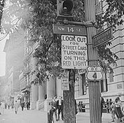
In the 1980s, a portion of 14th Street became known primarily for its red-light district
Red-light district
A red-light district is a part of an urban area where there is a concentration of prostitution and sex-oriented businesses, such as sex shops, strip clubs, adult theaters, etc...
. Many strip clubs and massage parlors were concentrated roughly between New York Avenue
New York Avenue (Washington, D.C.)
New York Avenue is one of the diagonal avenues radiating from the White House in Washington, D.C. It is a major east-west route in the city's Northwest and Northeast quadrants and connects downtown with points east and north of the city via Cheverly, Maryland, the John Hanson Highway and the...
and K Street, while prostitutes plied their trade around Logan Circle. However, rising land values eventually pushed out the adult businesses. The Source Theatre, founded by Bart Whiteman
Bart Whiteman
Bart Whiteman was a Washington, D.C. theatre actor, director, and producer. He founded the Source Theatre in 1977 and served as its artistic director until 1986. He was influential in defining theatre in Washington as well as reviving 14th Street...
, was given some credit for the area's revival. Whiteman stood outside the theater to escort people inside in order to make them feel safer.
With the gentrification of the neighborhoods through which it passes – particularly downtown, Logan Circle, the U Street Corridor
U Street Corridor
The U Street Corridor is a commercial and residential neighborhood in Northwest Washington, D.C with many shops, restaurants, nightclubs, art galleries, and music venues along a nine-block stretch of U Street. It extends from 9th Street on the east to 18th Street and Florida Avenue on the west...
, and Columbia Heights
Columbia Heights, Washington, D.C.
Columbia Heights is a neighborhood in central Washington, D.C.-Geography:Located in the Northwest quadrant of Washington, D.C., Columbia Heights borders the neighborhoods of Shaw, Adams Morgan, Mount Pleasant, Park View, Pleasant Plains, and Petworth. On the eastern side is Howard University...
– 14th Street is now known for live theater, art galleries, and trendy restaurants. Moreover, while the nominal center of the city's gay
LGBT
LGBT is an initialism that collectively refers to "lesbian, gay, bisexual, and transgender" people. In use since the 1990s, the term "LGBT" is an adaptation of the initialism "LGB", which itself started replacing the phrase "gay community" beginning in the mid-to-late 1980s, which many within the...
life is still Dupont Circle
Dupont Circle
Dupont Circle is a traffic circle, park, neighborhood, and historic district in Northwest Washington, D.C. The traffic circle is located at the intersection of Massachusetts Avenue NW, Connecticut Avenue NW, New Hampshire Avenue NW, P Street NW, and 19th Street NW...
, the Washington Blade called 14th Street between U Street and Massachusetts Avenue (Thomas Circle
Thomas Circle
Thomas Circle is a traffic circle in Northwest Washington, D.C., United States at the junction of Massachusetts Avenue, Vermont Avenue, 14th Street, and M Street, N.W.The through lanes of Massachusetts Avenue pass under Thomas Circle...
) the best place to see and be seen.
Landmarks
- The Black Cat
- Columbia Heights Metro stationColumbia Heights (Washington Metro)Columbia Heights is a Washington Metro station in Washington, D.C., on the Green Line. It is also served by the Yellow Line during off-peak times...
- DC USADC USADC USA is an retail development in the Columbia Heights neighborhood of Washington, D.C. A Washington City Paper poll named DC USA the "Best Designed Retail Space" of 2009....
- Freedom PlazaFreedom PlazaFreedom Plaza, originally known as Western Plaza, is an open plaza in Northwest Washington, D.C., United States, located at the corner of 14th Street and Pennsylvania Avenue NW, adjacent to Pershing Park. Constructed in 1980, the plaza is mostly composed of stone, inlaid with a depiction of parts...
- Garfinckel'sGarfinckel'sGarfinckel's was a prominent department store chain based in Washington, D.C., that catered to a clientele of wealthy consumers. It declared Chapter 11, in June 1990, and ceased operations in 1990.-History:...
- John A. Wilson BuildingJohn A. Wilson BuildingThe John A. Wilson Building, popularly known simply as the Wilson Building or the JAWB, houses the offices and chambers of the Mayor and Council of the District of Columbia. Originally called the District Building, it was renamed in 1994 to commemorate former Council Chair John A. Wilson...
- National AquariumNational Aquarium in Washington, D.C.The National Aquarium, Washington, D.C. is an aquarium in Washington D.C. It is located in the Herbert C. Hoover Building , which is bounded by 14th Street NW on the east, 15th Street NW on the west, Pennsylvania Avenue NW on the north, and Constitution Avenue NW on the south.-History:The National...
- National City Christian ChurchNational City Christian ChurchNational City Christian Church, located on Thomas Circle in Washington, D.C., is the national cathedral for the Christian Church , often abbreviated as the "Disciples of Christ" or "Christian Church"...
- National Museum of American HistoryNational Museum of American HistoryThe National Museum of American History: Kenneth E. Behring Center collects, preserves and displays the heritage of the United States in the areas of social, political, cultural, scientific and military history. Among the items on display are the original Star-Spangled Banner and Archie Bunker's...
- National Press Building
- Oscar Straus MemorialOscar Straus MemorialThe Oscar S. Straus Memorial in Washington, D.C., commemorates the accomplishments of the first Jew to serve in the cabinet of a U.S. president. Oscar Solomon Straus served as Secretary of Commerce and Labor under President Theodore Roosevelt from 1906 to 1909...
- Pershing ParkPershing ParkPershing Park is a memorial park dedicated to General John J. Pershing located at 14th Street and Pennsylvania Avenue NW in Washington, D.C., in the United States....
- Ronald Reagan BuildingRonald Reagan BuildingThe Ronald Reagan Building and International Trade Center, named after former United States President Ronald Reagan, is the first federal building in Washington, D.C. designed for both governmental and private sector purposes....
- Thomas CircleThomas CircleThomas Circle is a traffic circle in Northwest Washington, D.C., United States at the junction of Massachusetts Avenue, Vermont Avenue, 14th Street, and M Street, N.W.The through lanes of Massachusetts Avenue pass under Thomas Circle...
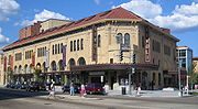
- Tivoli TheatreTivoli Theatre (Washington)The Tivoli Theatre is a landmark building in the Columbia Heights neighborhood of Washington, D.C. on 14th Street and Park Road Northwest. Originally built as a movie theater, it currently exhibits live stage productions as the home of the GALA Hispanic Theatre.-History:The Tivoli Theatre was...
- United States Department of CommerceUnited States Department of CommerceThe United States Department of Commerce is the Cabinet department of the United States government concerned with promoting economic growth. It was originally created as the United States Department of Commerce and Labor on February 14, 1903...
- United States Holocaust Memorial MuseumUnited States Holocaust Memorial MuseumThe United States Holocaust Memorial Museum is the United States' official memorial to the Holocaust. Adjacent to the National Mall in Washington, D.C., the USHMM provides for the documentation, study, and interpretation of Holocaust history...
- Walter Reed Army Medical CenterWalter Reed Army Medical CenterThe Walter Reed Army Medical Center was the United States Army's flagship medical center until 2011. Located on 113 acres in Washington, D.C., it served more than 150,000 active and retired personnel from all branches of the military...
- Willard InterContinental WashingtonWillard InterContinental WashingtonThe Willard InterContinental Washington is an historic luxury Beaux-Arts hotel located at 1401 Pennsylvania Avenue NW in Washington, D.C. Among its facilities are numerous luxurious guest rooms, several restaurants, the famed Round Robin Bar, the Peacock Alley series of luxury shops, and voluminous...
Transit service

Capital Traction Company
The Capital Traction Company was the smaller of the two major street railway companies in Washington, D.C. in the early 20th Century. It was formed through a merger of the Rock Creek Railway and the Washington and Georgetown Railroad Company in 1895. The company ran streetcars from Georgetown;...
streetcar line was built around the turn of the 20th century. The successor to that line is the Metrobus
Metrobus (Washington, D.C.)
Metrobus is a bus service operated by the Washington Metropolitan Area Transit Authority . Its fleet consists of 1,480 buses covering an area of in Washington, D.C., Maryland, and Virginia. There are over 300 bus routes serving 12,216 stops, including 2,398 bus shelters. In fiscal year 2009,...
14th Street Line—routes 52, 53, and 54.
Metrorail
There are two MetrorailWashington Metro
The Washington Metro, commonly called Metro, and unofficially Metrorail, is the rapid transit system in Washington, D.C., United States, and its surrounding suburbs. It is administered by the Washington Metropolitan Area Transit Authority , which also operates Metrobus service under the Metro name...
stations on 14th Street:
- McPherson SquareMcPherson Square (Washington Metro)McPherson Square is a side platformed Washington Metro station in Downtown Washington, D.C., United States. The station was opened on July 1, 1977, and is operated by the Washington Metropolitan Area Transit Authority...
- Columbia HeightsColumbia Heights (Washington Metro)Columbia Heights is a Washington Metro station in Washington, D.C., on the Green Line. It is also served by the Yellow Line during off-peak times...
Metrobus
The following Metrobus routes travel along the street (listed from south to north):- 11Y (Eye St. NW to the 14th Street Bridge)
- 13A, 13B, 13F, 13G (Independence Ave. to the 14th Street Bridge)
- 52 (Aspen St. to Independence Ave.)
- 53 (Aspen St. to Pennsylvania Ave.)
- 54 (Aspen St. to F St. NW)
- E2, E3, E4 (Military Rd. to Kennedy St.)
DC Circulator
The DC Circulator'sDC Circulator
The DC Circulator is a bus system in Washington, D.C. The system is a public-private partnership between the District of Columbia Department of Transportation, the Washington Metropolitan Area Transit Authority, and DC Surface Transit, Inc., operated by First Transit.The concept of a separate...
Woodley Park–Adams Morgan
Adams Morgan
Adams Morgan is a culturally diverse neighborhood in Northwest Washington, D.C., centered at the intersection of 18th Street and Columbia Road. Adams Morgan is considered the center of Washington's Hispanic immigrant community, and is a major night life area with many bars and restaurants,...
–McPherson Square Metro
McPherson Square (Washington Metro)
McPherson Square is a side platformed Washington Metro station in Downtown Washington, D.C., United States. The station was opened on July 1, 1977, and is operated by the Washington Metropolitan Area Transit Authority...
bus line travels along 14th Street between Columbia Heights
Columbia Heights, Washington, D.C.
Columbia Heights is a neighborhood in central Washington, D.C.-Geography:Located in the Northwest quadrant of Washington, D.C., Columbia Heights borders the neighborhoods of Shaw, Adams Morgan, Mount Pleasant, Park View, Pleasant Plains, and Petworth. On the eastern side is Howard University...
and downtown. Service operates at 10 minute intervals from 7:00AM - 12:00AM Sunday through Thursday and 7:00AM - 3:30AM Friday and Saturday.