
Lowndesboro, Alabama
Encyclopedia
Lowndesboro is a town in Lowndes County
, Alabama
, United States
. At the 2000 census the population was 140. It is part of the Montgomery
Metropolitan Statistical Area
.
. In 1832, the residents changed the name to Lowndesboro in honor of U.S. Congressman William Lowndes, the son of Rawlins Lowndes
, an early South Carolina
governor.
With its proximity to the Alabama River
, the community had grown into a prosperous town by the 1830s. Many wealthy planters settled in the area, leaving a legacy of historic mid-19th century architecture that largely survived intact into the modern era. A brief skirmish was fought at Lowndesboro in April 1865 between a group of Confederate
cavalry
and advance troops of the Union Army
during Wilson's Raid
. Federal troops occupied the town after driving off the Confederate force, with very little destruction noted from the occupation.
Like many small Southern
communities with an economy based on cotton
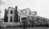
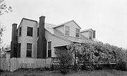
production and trade, Lowndesboro declined rapidly in the post-war years. At least partially attributed to this decline was the survival of much of the pre-war architecture into the 20th century, making it a unique assemblage of 19th century architecture. Today much of the town is included in the Lowndesboro Historic District
, listed on the National Register of Historic Places
. The Dicksonia Plantation ruins are also a notable place of interest.
On March 25, 1965, civil rights worker Viola Liuzzo
was shot to death during a high-speed chase by Ku Klux Klan
members on U.S. Route 80
, while driving to Montgomery
to pick up a group of demonstrators waiting to return to Selma after the Selma-to-Montgomery march
. The Klansmen spotted the white Liuzzo and her black passenger, Leroy Moton, at a stoplight in Selma, catching up to the pair about two miles (3 km) west of Lowndesboro.
According to the U.S. Census Bureau, the town has a total area of 0.8 square miles (2.1 km²), all of it land.
 As of the census
of 2000, there were 140 people, 58 households, and 40 families residing in the town. The population density
was 176.0 people per square mile (67.6/km²). There were 62 housing units at an average density of 77.9 per square mile (29.9/km²). The racial makeup of the town was 71.43% White
, 25.00% Black
or African American
, 1.43% from other races
, and 2.14% from two or more races. 3.57% of the population were Hispanic
or Latino
of any race.
There were 58 households out of which 29.3% had children under the age of 18 living with them, 55.2% were married couples
living together, 12.1% had a female householder with no husband present, and 31.0% were non-families. 29.3% of all households were made up of individuals and 20.7% had someone living alone who was 65 years of age or older. The average household size was 2.41 and the average family size was 2.98.
In the town the population was spread out with 27.1% under the age of 18, 4.3% from 18 to 24, 27.9% from 25 to 44, 17.1% from 45 to 64, and 23.6% who were 65 years of age or older. The median age was 42 years. For every 100 females there were 94.4 males. For every 100 females age 18 and over, there were 88.9 males.
The median income for a household in the town was $27,917, and the median income for a family was $35,833. Males had a median income of $23,750 versus $41,250 for females. The per capita income
for the town was $17,101. There were 16.0% of families and 29.7% of the population living below the poverty line, including 39.4% of under eighteens and 38.6% of those over 64.
Lowndes County, Alabama
Lowndes County is a county of the U.S. state of Alabama. It is named in honor of William Lowndes, a member of the United States Congress from South Carolina. As of the 2010 census, the population was 11,299...
, Alabama
Alabama
Alabama is a state located in the southeastern region of the United States. It is bordered by Tennessee to the north, Georgia to the east, Florida and the Gulf of Mexico to the south, and Mississippi to the west. Alabama ranks 30th in total land area and ranks second in the size of its inland...
, United States
United States
The United States of America is a federal constitutional republic comprising fifty states and a federal district...
. At the 2000 census the population was 140. It is part of the Montgomery
Montgomery, Alabama
Montgomery is the capital of the U.S. state of Alabama, and is the county seat of Montgomery County. It is located on the Alabama River southeast of the center of the state, in the Gulf Coastal Plain. As of the 2010 census, Montgomery had a population of 205,764 making it the second-largest city...
Metropolitan Statistical Area
Montgomery Metropolitan Area
The Montgomery, Alabama Metropolitan Statistical Area is a metropolitan statistical area in central Alabama...
.
History
Originally known as McGill's Hill, the community began attracting settlers following the conclusion of the Creek WarCreek War
The Creek War , also known as the Red Stick War and the Creek Civil War, began as a civil war within the Creek nation...
. In 1832, the residents changed the name to Lowndesboro in honor of U.S. Congressman William Lowndes, the son of Rawlins Lowndes
Rawlins Lowndes
Rawlins Lowndes was an American lawyer and politician from South Carolina. His sons, Thomas and William Lowndes, both served in the U.S. Congress....
, an early South Carolina
South Carolina
South Carolina is a state in the Deep South of the United States that borders Georgia to the south, North Carolina to the north, and the Atlantic Ocean to the east. Originally part of the Province of Carolina, the Province of South Carolina was one of the 13 colonies that declared independence...
governor.
With its proximity to the Alabama River
Alabama River
The Alabama River, in the U.S. state of Alabama, is formed by the Tallapoosa and Coosa rivers, which unite about north of Montgomery.The river flows west to Selma, then southwest until, about from Mobile, it unites with the Tombigbee, forming the Mobile and Tensaw rivers, which discharge into...
, the community had grown into a prosperous town by the 1830s. Many wealthy planters settled in the area, leaving a legacy of historic mid-19th century architecture that largely survived intact into the modern era. A brief skirmish was fought at Lowndesboro in April 1865 between a group of Confederate
Confederate States of America
The Confederate States of America was a government set up from 1861 to 1865 by 11 Southern slave states of the United States of America that had declared their secession from the U.S...
cavalry
Cavalry
Cavalry or horsemen were soldiers or warriors who fought mounted on horseback. Cavalry were historically the third oldest and the most mobile of the combat arms...
and advance troops of the Union Army
Union Army
The Union Army was the land force that fought for the Union during the American Civil War. It was also known as the Federal Army, the U.S. Army, the Northern Army and the National Army...
during Wilson's Raid
Wilson's Raid
Wilson's Raid was a cavalry operation through Alabama and Georgia in March–April 1865, late in the American Civil War. Brig. Gen. James H. Wilson led his Union Army Cavalry Corps to destroy Southern manufacturing facilities and was opposed unsuccessfully by a much smaller force under ...
. Federal troops occupied the town after driving off the Confederate force, with very little destruction noted from the occupation.
Like many small Southern
Southern United States
The Southern United States—commonly referred to as the American South, Dixie, or simply the South—constitutes a large distinctive area in the southeastern and south-central United States...
communities with an economy based on cotton
Cotton
Cotton is a soft, fluffy staple fiber that grows in a boll, or protective capsule, around the seeds of cotton plants of the genus Gossypium. The fiber is almost pure cellulose. The botanical purpose of cotton fiber is to aid in seed dispersal....
production and trade, Lowndesboro declined rapidly in the post-war years. At least partially attributed to this decline was the survival of much of the pre-war architecture into the 20th century, making it a unique assemblage of 19th century architecture. Today much of the town is included in the Lowndesboro Historic District
Lowndesboro Historic District
The Lowndesboro Historic District is a historic district in Lowndesboro, Alabama, United States. It was placed on the National Register of Historic Places on December 12, 1973. The district covers , spread over the entire town, and contains 20 contributing properties, including Meadowlawn Plantation...
, listed on the National Register of Historic Places
National Register of Historic Places
The National Register of Historic Places is the United States government's official list of districts, sites, buildings, structures, and objects deemed worthy of preservation...
. The Dicksonia Plantation ruins are also a notable place of interest.
On March 25, 1965, civil rights worker Viola Liuzzo
Viola Liuzzo
Viola Fauver Gregg Liuzzo was a Unitarian Universalist civil rights activist from Michigan, who was murdered by Ku Klux Klan members after the 1965 Selma to Montgomery marches in Alabama...
was shot to death during a high-speed chase by Ku Klux Klan
Ku Klux Klan
Ku Klux Klan, often abbreviated KKK and informally known as the Klan, is the name of three distinct past and present far-right organizations in the United States, which have advocated extremist reactionary currents such as white supremacy, white nationalism, and anti-immigration, historically...
members on U.S. Route 80
U.S. Route 80
U.S. Route 80 is an east–west United States highway, much of which was once part of the early auto trail known as the Dixie Overland Highway. As the "0" in the route number indicates, it was originally a cross-country route, from the Atlantic to the Pacific...
, while driving to Montgomery
Montgomery, Alabama
Montgomery is the capital of the U.S. state of Alabama, and is the county seat of Montgomery County. It is located on the Alabama River southeast of the center of the state, in the Gulf Coastal Plain. As of the 2010 census, Montgomery had a population of 205,764 making it the second-largest city...
to pick up a group of demonstrators waiting to return to Selma after the Selma-to-Montgomery march
Selma to Montgomery marches
The Selma to Montgomery marches were three marches in 1965 that marked the political and emotional peak of the American civil rights movement. They grew out of the voting rights movement in Selma, Alabama, launched by local African-Americans who formed the Dallas County Voters League...
. The Klansmen spotted the white Liuzzo and her black passenger, Leroy Moton, at a stoplight in Selma, catching up to the pair about two miles (3 km) west of Lowndesboro.
Geography
Lowndesboro is located at 32°16′23"N 86°36′36"W (32.273118, -86.609915).According to the U.S. Census Bureau, the town has a total area of 0.8 square miles (2.1 km²), all of it land.
Demographics
Census
A census is the procedure of systematically acquiring and recording information about the members of a given population. It is a regularly occurring and official count of a particular population. The term is used mostly in connection with national population and housing censuses; other common...
of 2000, there were 140 people, 58 households, and 40 families residing in the town. The population density
Population density
Population density is a measurement of population per unit area or unit volume. It is frequently applied to living organisms, and particularly to humans...
was 176.0 people per square mile (67.6/km²). There were 62 housing units at an average density of 77.9 per square mile (29.9/km²). The racial makeup of the town was 71.43% White
Race (United States Census)
Race and ethnicity in the United States Census, as defined by the Federal Office of Management and Budget and the United States Census Bureau, are self-identification data items in which residents choose the race or races with which they most closely identify, and indicate whether or not they are...
, 25.00% Black
Race (United States Census)
Race and ethnicity in the United States Census, as defined by the Federal Office of Management and Budget and the United States Census Bureau, are self-identification data items in which residents choose the race or races with which they most closely identify, and indicate whether or not they are...
or African American
Race (United States Census)
Race and ethnicity in the United States Census, as defined by the Federal Office of Management and Budget and the United States Census Bureau, are self-identification data items in which residents choose the race or races with which they most closely identify, and indicate whether or not they are...
, 1.43% from other races
Race (United States Census)
Race and ethnicity in the United States Census, as defined by the Federal Office of Management and Budget and the United States Census Bureau, are self-identification data items in which residents choose the race or races with which they most closely identify, and indicate whether or not they are...
, and 2.14% from two or more races. 3.57% of the population were Hispanic
Race (United States Census)
Race and ethnicity in the United States Census, as defined by the Federal Office of Management and Budget and the United States Census Bureau, are self-identification data items in which residents choose the race or races with which they most closely identify, and indicate whether or not they are...
or Latino
Race (United States Census)
Race and ethnicity in the United States Census, as defined by the Federal Office of Management and Budget and the United States Census Bureau, are self-identification data items in which residents choose the race or races with which they most closely identify, and indicate whether or not they are...
of any race.
There were 58 households out of which 29.3% had children under the age of 18 living with them, 55.2% were married couples
Marriage
Marriage is a social union or legal contract between people that creates kinship. It is an institution in which interpersonal relationships, usually intimate and sexual, are acknowledged in a variety of ways, depending on the culture or subculture in which it is found...
living together, 12.1% had a female householder with no husband present, and 31.0% were non-families. 29.3% of all households were made up of individuals and 20.7% had someone living alone who was 65 years of age or older. The average household size was 2.41 and the average family size was 2.98.
In the town the population was spread out with 27.1% under the age of 18, 4.3% from 18 to 24, 27.9% from 25 to 44, 17.1% from 45 to 64, and 23.6% who were 65 years of age or older. The median age was 42 years. For every 100 females there were 94.4 males. For every 100 females age 18 and over, there were 88.9 males.
The median income for a household in the town was $27,917, and the median income for a family was $35,833. Males had a median income of $23,750 versus $41,250 for females. The per capita income
Per capita income
Per capita income or income per person is a measure of mean income within an economic aggregate, such as a country or city. It is calculated by taking a measure of all sources of income in the aggregate and dividing it by the total population...
for the town was $17,101. There were 16.0% of families and 29.7% of the population living below the poverty line, including 39.4% of under eighteens and 38.6% of those over 64.