

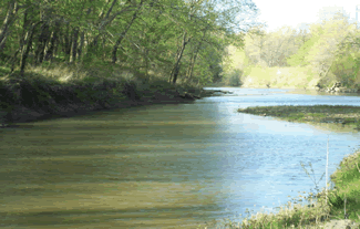
Loutre River
Encyclopedia
Missouri River
The Missouri River flows through the central United States, and is a tributary of the Mississippi River. It is the longest river in North America and drains the third largest area, though only the thirteenth largest by discharge. The Missouri's watershed encompasses most of the American Great...
in the United States
United States
The United States of America is a federal constitutional republic comprising fifty states and a federal district...
. The Loutre River, beginning as Little Loutre Creek in Audrain County
Audrain County, Missouri
Audrain County is a county located in the U.S. state of Missouri. As of 2010, the population was 25,529. Its county seat is Mexico. The county was organized in 1836. Audrain County was named for Col. James Hunter Audrain. Col. Audrain was Colonel of militia in the War of 1812. In 1830 Col...
, is fed along its path by many small creeks and streams. It flows into the Missouri River from the north in Montgomery County
Montgomery County, Missouri
Montgomery County is a county located in the U.S. state of Missouri. It lies in East Central Missouri, approximately halfway between Columbia and St. Louis. As of 2000, the population was 12,136. It was named in honor of Richard Montgomery, an American Revolutionary War general killed in 1775...
opposite the town of Hermann
Hermann, Missouri
Hermann is a city designated in 1842 as the county seat of Gasconade County, Missouri, United States. It is near the center of the Missouri Rhineland and south of the Missouri River. The population was 2,674 at the 2000 census....
. Loutre, meaning "otter
Otter
The Otters are twelve species of semi-aquatic mammals which feed on fish and shellfish, and also other invertebrates, amphibians, birds and small mammals....
", was applied to the river by French
New France
New France was the area colonized by France in North America during a period beginning with the exploration of the Saint Lawrence River by Jacques Cartier in 1534 and ending with the cession of New France to Spain and Great Britain in 1763...
trappers.
History
The Loutre River is threaded through the area's history. It was the means of transportation and the trade route for Native Americans, early European and American settlers in early Montgomery CountryMontgomery County, Missouri
Montgomery County is a county located in the U.S. state of Missouri. It lies in East Central Missouri, approximately halfway between Columbia and St. Louis. As of 2000, the population was 12,136. It was named in honor of Richard Montgomery, an American Revolutionary War general killed in 1775...
.

Graham Cave State Park
Graham Cave State Park is a state park in the US state of Missouri consisting of located in Montgomery County. The park's namesake, Graham Cave, is a cave in St. Peters sandstone with an entrance wide and high and an extent of about into the hillside. The cave protects an historically...
in Montgomery County. Graham Cave is located in the hills directly above the river. When discovered, the cave helped rewrite history books. During archaeological excavation by the University of Missouri
University of Missouri
The University of Missouri System is a state university system providing centralized administration for four universities, a health care system, an extension program, five research and technology parks, and a publishing press. More than 64,000 students are currently enrolled at its four campuses...
from 1949 to 1955, the cave yielded evidence of ancient Dalton
Dalton
Dalton may refer to:-In Canada:* Dalton, Algoma District, Ontario* Dalton Armoury, a Canadian Forces facility primarily used by the Queen's Own Rifles of Canada- In the United Kingdom :* Dalton, Cumbria, England* Dalton, Dumfries and Galloway, Scotland...
and Archaic Period Native Americans. Within the cave was an ancient ceremonial location dating to 8000 B.C.E.
Loutre Township comprises the southern portion of Montgomery County. The first Europeans to settle in the county were on Loutre Island perhaps as early as 1798, while the country was under control of Spain
Spain
Spain , officially the Kingdom of Spain languages]] under the European Charter for Regional or Minority Languages. In each of these, Spain's official name is as follows:;;;;;;), is a country and member state of the European Union located in southwestern Europe on the Iberian Peninsula...
. The island
Island
An island or isle is any piece of sub-continental land that is surrounded by water. Very small islands such as emergent land features on atolls can be called islets, cays or keys. An island in a river or lake may be called an eyot , or holm...
was first discovered by French trappers and voyageur
Voyageurs
The Voyageurs were the persons who engaged in the transportation of furs by canoe during the fur trade era. Voyageur is a French word which literally translates to "traveler"...
s.
Loutre Lick was one of the earliest settlements in Montgomery County, settled between 1808 and 1810, and named because of its location near a salt lick
Salt lick
A mineral lick is a natural mineral deposit where animals in nutrient-poor ecosystems can obtain essential mineral nutrients...
at the river. It was also called Van Bibbers Lick, for Major Isaac Van Bibber, who migrated in 1800 from Kentucky
Kentucky
The Commonwealth of Kentucky is a state located in the East Central United States of America. As classified by the United States Census Bureau, Kentucky is a Southern state, more specifically in the East South Central region. Kentucky is one of four U.S. states constituted as a commonwealth...
to Missouri
Missouri
Missouri is a US state located in the Midwestern United States, bordered by Iowa, Illinois, Kentucky, Tennessee, Arkansas, Oklahoma, Kansas and Nebraska. With a 2010 population of 5,988,927, Missouri is the 18th most populous state in the nation and the fifth most populous in the Midwest. It...
. Here he erected a hotel, some cabins, and stables. He tried unsuccessfully to operate a salt mill. Loutre Lick was succeeded by present-day Mineola, Missouri
Mineola, Missouri
Mineola is an unincorporated community in western Montgomery County, Missouri, United States. It is located about six miles south of Montgomery City on Missouri Supplemental Route J. It is about one mile from Interstate 70. Its post office closed in 1967 and mail now comes from Montgomery City. ...
.
Loutre Lick was probably the first mineral spring in Missouri to be developed as a kind of health resort. Here Daniel Boone
Daniel Boone
Daniel Boone was an American pioneer, explorer, and frontiersman whose frontier exploits mad']'e him one of the first folk heroes of the United States. Boone is most famous for his exploration and settlement of what is now the Commonwealth of Kentucky, which was then beyond the western borders of...
and Thomas Hart Benton
Thomas Hart Benton (senator)
Thomas Hart Benton , nicknamed "Old Bullion", was a U.S. Senator from Missouri and a staunch advocate of westward expansion of the United States. He served in the Senate from 1821 to 1851, becoming the first member of that body to serve five terms...
sought relief for their ailments. Benton bragged of the Loutre Lick spring in the halls of Congress, where Henry Clay
Henry Clay
Henry Clay, Sr. , was a lawyer, politician and skilled orator who represented Kentucky separately in both the Senate and in the House of Representatives...
referred to him as the "Senator from Missouri's Bethesda
Pool of Bethesda
The Pool of Bethesda is a pool of water in the Muslim Quarter of Jerusalem, on the path of the Beth Zeta Valley. The Gospel of John describes such a pool in Jerusalem, near the Sheep Gate, which is surrounded by five covered colonnades. It is associated with healing. Until the 19th century, there...
."
Skirmishes took place between Indians
Native Americans in the United States
Native Americans in the United States are the indigenous peoples in North America within the boundaries of the present-day continental United States, parts of Alaska, and the island state of Hawaii. They are composed of numerous, distinct tribes, states, and ethnic groups, many of which survive as...
and encroaching settlers. The Army established Fort Clemson on Loutre Island as a base of operations to protect American settlers. In March 1815, Captain Callaway and three soldiers (James McMillin, Parks Hutchings, Frank McDermid) were killed after pursuing Sauk and Fox
Meskwaki
The Meskwaki are a Native American people often known to outsiders as the Fox tribe. They have often been closely linked to the Sauk people. In their own language, the Meskwaki call themselves Meshkwahkihaki, which means "the Red-Earths." Historically their homelands were in the Great Lakes region...
Indians who had stolen horses from settlers. Captain Callaway, with Lieutenant Riggs and fourteen men left Fort Clemson, on Loutre Island, in pursuit of the Indians. While they first recaptured the horses about 12 miles away guarded mostly by squaws, the Army group was later fired upon by the Indian warriors. Captain Callaway's body was not found until several days after his death, when it was discovered by Benjamin Howell. His gun had been recovered several days before. Callaway and his three soldiers were buried where they had been killed. Headstones can be found at the burial site today on private property. They are in the middle of a sheep grazing field about 100 yards from the banks of the river and 300 yards from the Loutre River crossing of Mill Pond Road in rural Montgomery County.
Around September 1, 1832 famed author Washington Irving
Washington Irving
Washington Irving was an American author, essayist, biographer and historian of the early 19th century. He was best known for his short stories "The Legend of Sleepy Hollow" and "Rip Van Winkle", both of which appear in his book The Sketch Book of Geoffrey Crayon, Gent. His historical works...
visited Montgomery County on his way to the far west. He stayed about one day at Loutre Lick, where he wandered among the picturesque hills in the vicinity. To Major Van Bibber he said, "When I get rich I'm coming to this place and build a nice residence here."
While most of the springs used commercially in the 1800s and early 1900s have since stopped flowing, several springs can still be found, especially along the banks of the river at Mineola. Isaac Van Bibber's house in Mineola has a continuous spring that flows year round through its original rock basement. It is believed many of the springs arose after the 1812 New Madrid Earthquake
New Madrid earthquake
The 1811-1812 New Madrid earthquakes were an intense intraplate earthquake series beginning with an initial pair of very large earthquakes on December 16, 1811. These earthquakes remain the most powerful earthquakes ever to hit the eastern United States in recorded history...
.
The Loutre Island area is commonly associated with the German-founded towns of Rhineland
Rhineland, Missouri
Rhineland is a village in Montgomery County, Missouri, United States. The population was 176 at the 2000 census, at which time it was a town. Its name came from German immigrants from the River Rhine area....
and Starkenburg, which has several historically significant Catholic churches and sites, including the Shrine of Our Lady of Sorrows
Shrine of Our Lady of Sorrows
The Shrine of Our Lady of Sorrows is a Roman Catholic church in Starkenburg, Montgomery County, Missouri. It replaced an earlier 19th century log church, which was retained on the site as a chapel. Both were built by a congregation of mid-19th century German immigrants and their descendants...
, a church devoted to the Virgin Mary. These were originally German-language congregations, part of German settlement in the mid-19th century. The settlers came from Hermann, on the south side of the Missouri. They founded vineyards in this area as well.
Present day
In July 2000 Cargill Pork, Inc.'s hog farmIntensive pig farming
Intensive piggeries are a type of factory farm ' specialized in the raising of domestic pigs up to slaughter weight...
in Martinsburg, Missouri
Martinsburg, Missouri
Martinsburg is a city in Audrain County, Missouri, United States. The population was 326 at the 2000 census, at which time it was a town.-Geography:Martinsburg is located at ....
illegally discharged hog waste from its holding ponds into the Loutre River. The United States Environmental Protection Agency said the release occurred because of improper handling of waste management equipment by Cargill Pork, Inc., a subsidiary of Cargill
Cargill
Cargill, Incorporated is a privately held, multinational corporation based in Minnetonka, Minnesota. Founded in 1865, it is now the largest privately held corporation in the United States in terms of revenue. If it were a public company, it would rank, as of 2011, number 13 on the Fortune 500,...
. After the waste release, which occurred over a five-day period, the EPA said 53,000 fish were killed along a five-mile stretch of the river. Cargill was fined $1.55 million, including $51,000 as restitution for damage to the environment
Natural environment
The natural environment encompasses all living and non-living things occurring naturally on Earth or some region thereof. It is an environment that encompasses the interaction of all living species....
.
Missouri Department of Conservation
The Missouri Department of Conservation and the Missouri Conservation Commission were created by Article IV Sections 40-42 of the Missouri Constitution, which were adopted by the voters of the state in 1936 as Amendment 4 to the constitution...
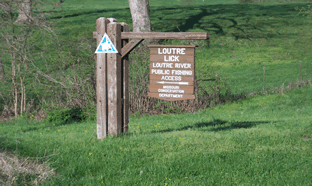
owns and maintains the Loutre Lick Public Fishing Access (163 acres) 3 miles south of I-70 on Route N (Mineola exit) then three-quarters of a mile on County Road 278. Bass, catfish, sunfish, and crappie are abundant in this section of the river. The forest, cropland, and old fields also provide for good public deer, dove, quail, rabbit, squirrel, turkey, and waterfowl hunting. Trapping is allowed with a Special Use Permit.
Graham Cave State Park maintains a paved boat access to the river accessible for free by park patrons with a large paved parking area along with barbecue
Barbecue
Barbecue or barbeque , used chiefly in the United States, Canada, the United Kingdom, New Zealand and Australia is a method and apparatus for cooking meat, poultry and occasionally fish with the heat and hot smoke of a fire, smoking wood, or hot coals of...
grills and picnic tables. The park also maintains the Loutre River trail, a publicly accessible hiking and mountain biking trail that runs adjacent to the river bank for about one-half mile.
The Loutre River, the Auxvasse Creek, and the Prairie Fork Creek are the only known bodies of water where the rare blacknose shiner
Blacknose Shiner
Blacknose Shiner is a species of ray-finned fish in the genus Notropis....
fish species can still be found in Missouri. The appearance of blacknose shiner is considered a marker of very high water quality and pristine stream conditions.
The Katy Trail State Park
Katy Trail State Park
The Katy Trail State Park is a recreation rail trail that runs in the right-of-way of the former Missouri-Kansas-Texas Railroad. The nickname "Katy" comes from the phonetic pronunciation of 'KT' in the railroad's abbreviated name, MKT. The trail, widely known as the Katy Trail, is a Missouri...
, a 225-mile-long former railroad bed converted to public use, crosses the Loutre River at McKittrick
McKittrick, Missouri
McKittrick is a city in Montgomery County, Missouri, United States. The population was 72 at the 2000 census, at which time it was a town.-Geography:McKittrick is located at ....
by means of an iron truss bridge built by the A.P. Roberts Company in 1897. It has been preserved with a wood deck for continued public use.
Interstate 70
Interstate 70
Interstate 70 is an Interstate Highway in the United States that runs from Interstate 15 near Cove Fort, Utah, to a Park and Ride near Baltimore, Maryland. It was the first Interstate Highway project in the United States. I-70 approximately traces the path of U.S. Route 40 east of the Rocky...
crosses the Loutre River in Montgomery County. The Interstate's dip into the Loutre River valley is known locally as Mineola Hill; it is one of the steepest grades on a Missouri Interstate highway. Just south of the highway crossing is Mineola and just north is Graham Cave.
A large piece of St. Peter Sandstone
St. Peter Sandstone
The St. Peter Sandstone is an Ordovician formation in the Chazyan stage of the Champlainian series. This sandstone originated as a sheet of sand in clear, shallow water near the shore of a Paleozoic sea and consists of fine-to-medium-size, well-rounded quartz grains with frosted surfaces...
is preserved in the median of the interstate as a historic site. It is known locally as "Slave Rock" or "Picnic Rock". Local tradition holds that before the abolition of slavery, periodic local slave auctions were held atop the rock. It was also the site of seasonal picnics held by the Graham family. Later they donated to the state the property where the Graham Cave was excavated. St. Peter Sandstone is believed by geologists to have formed the coast line of a prehistoric sea stretching from Minnesota
Minnesota
Minnesota is a U.S. state located in the Midwestern United States. The twelfth largest state of the U.S., it is the twenty-first most populous, with 5.3 million residents. Minnesota was carved out of the eastern half of the Minnesota Territory and admitted to the Union as the thirty-second state...
through Iowa
Iowa
Iowa is a state located in the Midwestern United States, an area often referred to as the "American Heartland". It derives its name from the Ioway people, one of the many American Indian tribes that occupied the state at the time of European exploration. Iowa was a part of the French colony of New...
, Illinois
Illinois
Illinois is the fifth-most populous state of the United States of America, and is often noted for being a microcosm of the entire country. With Chicago in the northeast, small industrial cities and great agricultural productivity in central and northern Illinois, and natural resources like coal,...
, and Missouri.
As part of the planned rebuild of Interstate 70 throughout Missouri, this particular stretch has generated some controversy. Highway engineers have to correct the steep grade while preserving the many historic and environmentally significant sites that surround it, including Slave Rock, the Loutre River, Graham Cave, Danville Glades Conservation Area, and others.
Seasonal flooding continues to alter the course of the river. The Loutre Island no longer exists, as the slough that once surrounded the island no longer connects to the river. The island has become part of the bank of the river. The now defunct but standing Loutre Island chapel is accessible from Missouri State Route 94. The Loutre Island Cemetery along Missouri State Route 19 still carries the Loutre Island name. Near Mineola, the river has begun to reclaim fertile cropland.
The Flood of 1993 raised water levels along the length of the Loutre River to great heights. Lasting changes of the flood can be seen in severely eroding banks along some sections. The breach of the eastern bank levee of the Loutre just south of the Katy Trail crossing at McKittrick created two large permanent lakes and washed out Missouri State Route 19. It created an 80 feet (24.4 m) crater that isolated the two banks of the river until it could be filled. Traveling on Route 19 through this area, visitors can still see evidence of the flooding. The two permanent lakes are visible to the west of the highway, where most trees and permanent foliage were destroyed by the breach.
Recently Asian carp
Asian carp
Many species of heavy-bodied cyprinid fish are collectively known in the United States as Asian carp. Cyprinids from the subcontinent [for example, catla and mrigal ] are not included in this classification, and are known collectively as "Indian carp".Eight Asian carp have been substantially...
have begun to inhabit the mouth of the river, arriving as an invasive species from the Missouri River. This sometimes makes boat fishing treacherous along the first 1–2 miles of the Loutre out of the Missouri.
See also
- Hermann, MissouriHermann, MissouriHermann is a city designated in 1842 as the county seat of Gasconade County, Missouri, United States. It is near the center of the Missouri Rhineland and south of the Missouri River. The population was 2,674 at the 2000 census....
- Americus, Missouri
- Williamsburg, MissouriWilliamsburg, MissouriWilliamsburg is an unincorporated community in eastern Callaway County, Missouri, USA. It is part of the Jefferson City, Missouri Metropolitan Statistical Area. It is home to Nine Mile Presbyterian church, presided over by James W. Cruickshank...
- Gasconade County, MissouriGasconade County, MissouriGasconade County is a county in the U.S. state of Missouri located on the south side of the Missouri River, which once served as the chief route of transportation in the state. Located in the area called the Missouri Rhineland, the county had a population of 15,342 as of the 2000 U.S. Census. A...
- Audrain County, MissouriAudrain County, MissouriAudrain County is a county located in the U.S. state of Missouri. As of 2010, the population was 25,529. Its county seat is Mexico. The county was organized in 1836. Audrain County was named for Col. James Hunter Audrain. Col. Audrain was Colonel of militia in the War of 1812. In 1830 Col...