
Katy Trail State Park
Encyclopedia

Rail trail
A rail trail is the conversion of a disused railway easement into a multi-use path, typically for walking, cycling and sometimes horse riding. The characteristics of former tracks—flat, long, frequently running through historical areas—are appealing for various development. The term sometimes also...
that runs 240 miles (386 km) in the right-of-way
Right-of-way (railroad)
A right-of-way is a strip of land that is granted, through an easement or other mechanism, for transportation purposes, such as for a trail, driveway, rail line or highway. A right-of-way is reserved for the purposes of maintenance or expansion of existing services with the right-of-way...
of the former Missouri-Kansas-Texas Railroad
Missouri-Kansas-Texas Railroad
The Missouri–Kansas–Texas Railroad was incorporated May 23, 1870. In its earliest days the MKT was commonly referred to as "the K-T", which was its stock exchange symbol; this common designation soon evolved into "the Katy"....
. The nickname "Katy" comes from the phonetic pronunciation of 'KT' in the railroad's abbreviated name, MKT. The trail, widely known as the Katy Trail, is a Missouri state park and is the longest Rails-to-Trails
Rails-to-Trails Conservancy
Rails-to-Trails Conservancy is an American nonprofit organization based in Washington, D.C. that works with communities to preserve unused rail corridors by transforming them into rail trails within the United States of America...
trail in the United States. Sections of the Katy are part of the Lewis and Clark National Historic Trail
Lewis and Clark National Historic Trail
The Lewis and Clark National Historic Trail is a route across the United States commemorating the Lewis and Clark Expedition of 1804 to 1806. It is part of the National Trails System of the United States...
and the American Discovery Trail
American Discovery Trail
The American Discovery Trail is a coast-to-coast hiking and biking trail across the mid-tier of the United States. It starts on the Delmarva Peninsula on the Atlantic Ocean and ends on the northern California coast on the Pacific Ocean, and is signed on over of trail. This includes the doubled...
. Most of the trail follows the northern bank of the Missouri River
Missouri River
The Missouri River flows through the central United States, and is a tributary of the Mississippi River. It is the longest river in North America and drains the third largest area, though only the thirteenth largest by discharge. The Missouri's watershed encompasses most of the American Great...
. The trail is open for use by hikers
Hiking
Hiking is an outdoor activity which consists of walking in natural environments, often in mountainous or other scenic terrain. People often hike on hiking trails. It is such a popular activity that there are numerous hiking organizations worldwide. The health benefits of different types of hiking...
, joggers
Jogging
Jogging is a form of trotting or running at a slow or leisurely pace. The main intention is to increase fitness with less stress on the body than from faster running.-Definition:...
, and cyclists
Cycling
Cycling, also called bicycling or biking, is the use of bicycles for transport, recreation, or for sport. Persons engaged in cycling are cyclists or bicyclists...
year-round, from sunrise to sunset. The trail is made up of "limestone pug" (crushed limestone
Limestone
Limestone is a sedimentary rock composed largely of the minerals calcite and aragonite, which are different crystal forms of calcium carbonate . Many limestones are composed from skeletal fragments of marine organisms such as coral or foraminifera....
), creating a hard flat surface.
History
On October 4, 1986, The Missouri-Kansas-Texas RailroadMissouri-Kansas-Texas Railroad
The Missouri–Kansas–Texas Railroad was incorporated May 23, 1870. In its earliest days the MKT was commonly referred to as "the K-T", which was its stock exchange symbol; this common designation soon evolved into "the Katy"....
operated the final trains from Sedalia, Missouri
Sedalia, Missouri
Sedalia is a city located about south of the Missouri River in Pettis County, Missouri. U.S. Highway 50 and U.S. Highway 65 intersect in the city. As of 2006, the city had a total population of 20,669. It is the county seat of Pettis County. The Sedalia Micropolitan Statistical Area consists of...
to Machens, Missouri. On that day, after their passage, floodwater from the Missouri River severely damaged the track along the route. After experiencing many washouts in the past along this line, the railroad decided it would not repair. Trains were re-routed, and the right of way was to be abandoned.
Conversion of the corridor from a railroad to a trail was made possible by the National Trails System Act of 1968. In 1982 the city of Columbia
Columbia, Missouri
Columbia is the fifth-largest city in Missouri, and the largest city in Mid-Missouri. With a population of 108,500 as of the 2010 Census, it is the principal municipality of the Columbia Metropolitan Area, a region of 164,283 residents. The city serves as the county seat of Boone County and as the...
opened the M.K.T. Trail
M.K.T. Trail
The M.K.T. Trail is a recreational rail trail in Columbia, Missouri, that runs nine miles in the right-of-way of the former Missouri-Kansas-Texas Railroad. Developed from 1982 onward, it is a spur of the longest rail-trail in the United States, the Katy Trail...
on an abandoned spur of the Katy as one of the first rails-to-trails pilot projects in the United States. Because of a donation from Edward D. "Ted" Jones of St. Louis
St. Louis, Missouri
St. Louis is an independent city on the eastern border of Missouri, United States. With a population of 319,294, it was the 58th-largest U.S. city at the 2010 U.S. Census. The Greater St...
the Missouri Department of Natural Resources was able to secure the right-of-way. In 1991 the Union Pacific Railroad
Union Pacific Railroad
The Union Pacific Railroad , headquartered in Omaha, Nebraska, is the largest railroad network in the United States. James R. Young is president, CEO and Chairman....
donated 33 miles (53 km) of additional right-of-way from Sedalia
Sedalia, Missouri
Sedalia is a city located about south of the Missouri River in Pettis County, Missouri. U.S. Highway 50 and U.S. Highway 65 intersect in the city. As of 2006, the city had a total population of 20,669. It is the county seat of Pettis County. The Sedalia Micropolitan Statistical Area consists of...
to Clinton
Clinton, Missouri
Clinton is a city in Henry County, Missouri, United States. The city was named for New York Governor DeWitt Clinton. The population was 9,311 at the 2000 census. It is the county seat of Henry County.-Geography:Clinton is located at...
. Based on the success of the M.K.T. and the mentioned donations the trail was scheduled for completion in 1994. However, the Great Flood of 1993
Great Flood of 1993
The Great Mississippi and Missouri Rivers Flood of 1993 occurred in the American Midwest, along the Mississippi and Missouri rivers and their tributaries, from April to October 1993. The flood was among the most costly and devastating to ever occur in the United States, with $15 billion in damages...
damaged 75 miles (121 km) of the original 126 miles (203 km) of the trail. The completed trail was finally opened 1996 with the section from Sedalia to Clinton opening in 1999.
The trail is currently being expanded to include the corridor from St. Charles to Machens. Plans are also underway to expand the trail to the suburbs of Kansas City
Kansas City, Missouri
Kansas City, Missouri is the largest city in the U.S. state of Missouri and is the anchor city of the Kansas City Metropolitan Area, the second largest metropolitan area in Missouri. It encompasses in parts of Jackson, Clay, Cass, and Platte counties...
and downtown St. Louis
St. Louis, Missouri
St. Louis is an independent city on the eastern border of Missouri, United States. With a population of 319,294, it was the 58th-largest U.S. city at the 2010 U.S. Census. The Greater St...
. A 2002 study by the Mid-America Regional Council
Mid-America Regional Council
The Mid-America Regional Council serves as the Council of Governments and the Metropolitan Planning Organization for the bistate Kansas City region. MARC encourages cooperation and collaboration on issues that extend beyond the jurisdiction of a single city, county or state...
gives a number of options for achieving this. One option, that AmerenUE allow the use of its unused Rock Island Corridor
Chicago, Rock Island and Pacific Railroad
The Chicago, Rock Island and Pacific Railroad was a Class I railroad in the United States. It was also known as the Rock Island Line, or, in its final years, The Rock.-Incorporation:...
rail line, received particular attention. Missouri Governor, Matt Blunt
Matt Blunt
Matthew Roy Blunt served as the 54th Governor of Missouri from 2005 to 2009. Before his election as governor, Blunt served ten years in the United States Navy, was elected to serve in the Missouri General Assembly in 1998 and as Missouri's Secretary of State in 2000.A Republican, Blunt was elected...
, asked Ameren to allow the use of the Rock Island Corridor for this purpose as compensation for a flood which devastated Johnson's Shut-ins State Park
Johnson's Shut-Ins State Park
Johnson's Shut-Ins State Park is a Missouri state park on the East Fork Black River consisting of in Reynolds County. The park is jointly administered with adjoining Taum Sauk Mountain State Park, and together the two parks cover in the St...
after the failure of a dam owned by Ameren. A settlement to this effect was reached in 2007, although no date has been given for project completion. There is an effort to create a four-state trail system using several trails already in existence including the Katy. This "quad state" trail would connect Missouri
Missouri
Missouri is a US state located in the Midwestern United States, bordered by Iowa, Illinois, Kentucky, Tennessee, Arkansas, Oklahoma, Kansas and Nebraska. With a 2010 population of 5,988,927, Missouri is the 18th most populous state in the nation and the fifth most populous in the Midwest. It...
, Kansas
Kansas
Kansas is a US state located in the Midwestern United States. It is named after the Kansas River which flows through it, which in turn was named after the Kansa Native American tribe, which inhabited the area. The tribe's name is often said to mean "people of the wind" or "people of the south...
, Iowa
Iowa
Iowa is a state located in the Midwestern United States, an area often referred to as the "American Heartland". It derives its name from the Ioway people, one of the many American Indian tribes that occupied the state at the time of European exploration. Iowa was a part of the French colony of New...
, and Nebraska
Nebraska
Nebraska is a state on the Great Plains of the Midwestern United States. The state's capital is Lincoln and its largest city is Omaha, on the Missouri River....
.
Route
Missouri River
The Missouri River flows through the central United States, and is a tributary of the Mississippi River. It is the longest river in North America and drains the third largest area, though only the thirteenth largest by discharge. The Missouri's watershed encompasses most of the American Great...
and runs along the northern bank of the river for most of the trail's length. The next major city along the trail is Jefferson City
Jefferson City, Missouri
Jefferson City is the capital of the U.S. state of Missouri and the county seat of Cole County. Located in Callaway and Cole counties, it is the principal city of the Jefferson City metropolitan area, which encompasses the entirety of both counties. As of the 2010 census, the population was 43,079...
— the state capital. At mile-marker 169 (McBaine) the trail intersects the M.K.T. which leads into downtown Columbia
Columbia, Missouri
Columbia is the fifth-largest city in Missouri, and the largest city in Mid-Missouri. With a population of 108,500 as of the 2010 Census, it is the principal municipality of the Columbia Metropolitan Area, a region of 164,283 residents. The city serves as the county seat of Boone County and as the...
, the largest city along the trail. The Katy then deviates from its original path and crosses the Missouri River at Boonville
Boonville, Missouri
This page is about the city in Missouri. For other communities of the same name, see Boonville Boonville is a city in Cooper County, Missouri, USA. The population was 8,202 at the 2000 census. It is the county seat of Cooper County. The city was the site of a skirmish early in the American Civil...
on the Boonslick Bridge
Boonslick Bridge
The Boonslick Bridge is a series of girder bridges on U.S. Route 40, Route 5 and Route 87 across the Missouri River between Cooper County, Missouri and Howard County, Missouri at Boonville, Missouri. It is named for Nathan Boone , who built a road between St...
instead of the original M.K.T. Bridge
Missouri-Kansas-Texas (MKT) Bridge
The Missouri–Kansas–Texas Bridge is a former rail bridge across the Missouri River at Boonville, Missouri that is now owned by the city of Boonville as of 2010...
. From here the trail runs to its terminus in Clinton
Clinton, Missouri
Clinton is a city in Henry County, Missouri, United States. The city was named for New York Governor DeWitt Clinton. The population was 9,311 at the 2000 census. It is the county seat of Henry County.-Geography:Clinton is located at...
.
| City | Mile-marker |
|---|---|
| Machens | 27 |
| St. Charles | 39 |
| Weldon Spring Weldon Spring, Missouri Weldon Spring is a city in St. Charles County, Missouri, United States. The population was 5,270 at the 2000 census. The city is named for its first settler, North Carolina frontiersman John Weldon, who in 1790 built a log home overlooking the spring which bears his name.-Geography:Weldon Spring... |
55 |
| Defiance Defiance, Missouri Defiance is an unincorporated community in Saint Charles County, Missouri, located on state highway 94.-Situation:The Katy Trail State Park runs through Defiance near the Missouri River. This was the final home of frontiersman Daniel Boone, who settled in the Femme Osage Valley in 1799 after... |
59 |
| Augusta Augusta, Missouri Augusta is a city in St. Charles County, Missouri, United States. The population was 218 at the 2000 census. The town boasts wineries, antique shops, retaurants, B&B's, a wood shop, a glass studio, massage therapy, and The Augusta Brewery.... |
66 |
| Hermann Hermann, Missouri Hermann is a city designated in 1842 as the county seat of Gasconade County, Missouri, United States. It is near the center of the Missouri Rhineland and south of the Missouri River. The population was 2,674 at the 2000 census.... |
100 |
| Bluffton Bluffton, Missouri Bluffton is an unincorporated community in western Montgomery County, Missouri, United States. It is located on Route 94 about ten miles west of Hermann near the Missouri River. It was originally known as Stringtown , and became Bluffton when a wine company with that name came to the town. Its... |
111 |
| Jefferson City Jefferson City, Missouri Jefferson City is the capital of the U.S. state of Missouri and the county seat of Cole County. Located in Callaway and Cole counties, it is the principal city of the Jefferson City metropolitan area, which encompasses the entirety of both counties. As of the 2010 census, the population was 43,079... |
143 |
| Hartsburg Hartsburg, Missouri Hartsburg is a village in Boone County, Missouri, United States. It is part of the Columbia, Missouri Metropolitan Statistical Area. The population was 108 at the 2000 census, at which time it was a town.-Geography:... |
153 |
| Columbia Columbia, Missouri Columbia is the fifth-largest city in Missouri, and the largest city in Mid-Missouri. With a population of 108,500 as of the 2010 Census, it is the principal municipality of the Columbia Metropolitan Area, a region of 164,283 residents. The city serves as the county seat of Boone County and as the... |
159 (via M.K.T. Trail M.K.T. Trail The M.K.T. Trail is a recreational rail trail in Columbia, Missouri, that runs nine miles in the right-of-way of the former Missouri-Kansas-Texas Railroad. Developed from 1982 onward, it is a spur of the longest rail-trail in the United States, the Katy Trail... ) |
| Rocheport Rocheport, Missouri Rocheport is a city in Boone County, Missouri, United States. It is part of the Columbia, Missouri Metropolitan Statistical Area. The population was 208 at the 2000 census... |
179 |
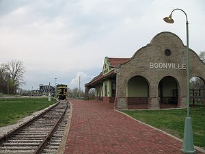
| Boonville Boonville, Missouri This page is about the city in Missouri. For other communities of the same name, see Boonville Boonville is a city in Cooper County, Missouri, USA. The population was 8,202 at the 2000 census. It is the county seat of Cooper County. The city was the site of a skirmish early in the American Civil... |
192 |
| Sedalia Sedalia, Missouri Sedalia is a city located about south of the Missouri River in Pettis County, Missouri. U.S. Highway 50 and U.S. Highway 65 intersect in the city. As of 2006, the city had a total population of 20,669. It is the county seat of Pettis County. The Sedalia Micropolitan Statistical Area consists of... |
227 |
| Clinton Clinton, Missouri Clinton is a city in Henry County, Missouri, United States. The city was named for New York Governor DeWitt Clinton. The population was 9,311 at the 2000 census. It is the county seat of Henry County.-Geography:Clinton is located at... |
262 |
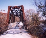
The MKT bridge at Boonville
Due to the Katy Trail's railbank status, it must always remain connected to the national railway network so that it could potentially be called back into active railway use. The segment of the trail between St. Charles and Sedalia was connected in two locations. One of these connections is in St. Charles and the other was provided by the Missouri-Kansas-Texas (MKT) BridgeMissouri-Kansas-Texas (MKT) Bridge
The Missouri–Kansas–Texas Bridge is a former rail bridge across the Missouri River at Boonville, Missouri that is now owned by the city of Boonville as of 2010...
at Boonville. The Missouri Department of Natural Resources was granted the right to keep the bridge in place and to use it at the MDNR's discretion as part of the trail per the following language of the Interim Trail Agreement signed 25 June 1987. However, on 28 April 2005, the Missouri Department of Natural Resources signed an amendment to the agreement abandoning its rights to the bridge and allowing Union Pacific to remove the bridge and thus creating two independent segments in the trail, east and west of Boonville respectively. The consequence of this is that if the connection in St. Charles is destroyed or otherwise rendered unusable by rail (such as by natural disaster), the segment of the trail between St. Charles and Boonville would lose its railbanked status and ownership of the land would probably revert back to its original owners from before the MKT Line was built. The same could happen to the segment east of Boonville if its connection is lost.
On February 4, 2010 Missouri Governor Jay Nixon
Jay Nixon
Jeremiah Wilson "Jay" Nixon, Sr. is the 55th and current Governor of the U.S. state of Missouri. A member of the Democratic Party, he previously served as Missouri's Attorney General before his election in 2008.-Political career:...
announced that Union Pacific Railroad
Union Pacific Railroad
The Union Pacific Railroad , headquartered in Omaha, Nebraska, is the largest railroad network in the United States. James R. Young is president, CEO and Chairman....
was giving to the City of Boonville, MO all ownership rights to the bridge, thereby ending a nearly six year dispute on what would become of the bridge and the trail. The city announced it would be restoring the bridge and incorporating it back into the Katy Trail bicycle and hiking trail.
Paving the M.K.T
In 2006, Ted Curtis, the senior planner for ColumbiaColumbia, Missouri
Columbia is the fifth-largest city in Missouri, and the largest city in Mid-Missouri. With a population of 108,500 as of the 2010 Census, it is the principal municipality of the Columbia Metropolitan Area, a region of 164,283 residents. The city serves as the county seat of Boone County and as the...
’s Non-Motorized Grant Program, proposed to pave the MKT Spur
M.K.T. Trail
The M.K.T. Trail is a recreational rail trail in Columbia, Missouri, that runs nine miles in the right-of-way of the former Missouri-Kansas-Texas Railroad. Developed from 1982 onward, it is a spur of the longest rail-trail in the United States, the Katy Trail...
of the Trail. While Curtis's proposal allows for the Trail to resist weather damage better and provides more recreational initiative for the Trail's use, many have protested the paving plan, claiming it would interfere with the enjoyment of nature and remove a major soft-surface path for runners. Curtis's response was to build spur trails that lead to creeks and other aspects of nature, and to leave a shoulder in the Trail for runners.http://www.columbiamissourian.com/news/story.php?ID=22146