
.gif)
Lost River (Idaho)
Encyclopedia
Big Lost River
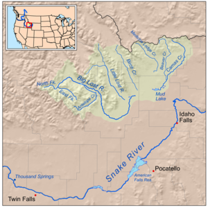
The Big Lost River is a major river in the U.S. state of Idaho, about long. It starts in the Rocky Mountains and flows in a generally southeast direction into the Snake River Plain. True to its name, the Big Lost River's surface flow does not reach any larger river, but vanishes into the Snake...
and the Little Lost River
Little Lost River
The Little Lost River is a river in the central part of the U.S. state of Idaho. The river is about long and drains an arid farming valley, the Little Lost River Valley, bordered by the Lost River Range on the west and Lemhi Range on the east...
. They are often considered separate streams, but both flow into the same depression and become subterranean, feeding the Snake River Plain Aquifer. The rivers are located in Custer County
Custer County, Idaho
Custer County is a rural mountain county located in the center of the U.S. state of Idaho. Established in 1881, it was named for the General Custer Mine, where gold was discovered five years earlier . The population was 4,342 at the 2000 census; it is estimated to have fallen to 4,166 by 2007...
and Butte County
Butte County, Idaho
Butte County is a rural county located in the U.S. state of Idaho. It was established in 1917, and its county seat and largest city is Arco. As of the 2010 census, the county had a population of 2,891...
, in Idaho
Idaho
Idaho is a state in the Rocky Mountain area of the United States. The state's largest city and capital is Boise. Residents are called "Idahoans". Idaho was admitted to the Union on July 3, 1890, as the 43rd state....
in the United States
United States
The United States of America is a federal constitutional republic comprising fifty states and a federal district...
. Via the aquifer
Aquifer
An aquifer is a wet underground layer of water-bearing permeable rock or unconsolidated materials from which groundwater can be usefully extracted using a water well. The study of water flow in aquifers and the characterization of aquifers is called hydrogeology...
and numerous springs
Spring (hydrosphere)
A spring—also known as a rising or resurgence—is a component of the hydrosphere. Specifically, it is any natural situation where water flows to the surface of the earth from underground...
, they are tributaries of the Snake River
Snake River
The Snake is a major river of the greater Pacific Northwest in the United States. At long, it is the largest tributary of the Columbia River, the largest North American river that empties into the Pacific Ocean...
.
Course
The Big Lost River is about 135 miles (217.3 km) long has two main tributary forks, the North Fork Big Lost River and the East Fork Big Lost River. The river originates in the Pioneer Mountains in Salmon-Challis National ForestSalmon-Challis National Forest
Salmon-Challis National Forest is located in east central sections of the U.S. state of Idaho. At 4,235,940 acres it is one of the largest national forests in the lower 48 states and also has most of the land area of the Frank Church River of No Return Wilderness, which is the largest wilderness...
, flows northeast then turns southeast, with the Lost River Range
Lost River Range
The Lost River Range is a group of high mountains located in central Idaho, in the northwestern United States. It runs southeast for approximately 75 miles from the Salmon River near the community of Challis to the Snake River Valley near Arco...
to the east separating the Big Lost River Valley from the Little Lost River Valley. A dam impounds the river and creates Mackay Reservoir. Near Arco
Arco, Idaho
Arco is a city in Butte County, Idaho, United States. The population was 995 at the 2010 census. The city is the county seat of Butte County.Craters of the Moon National Monument is located along U.S. Route 20, southwest of the city. The Idaho National Laboratory is located east of Arco...
the river enters the Snake River Plain
Snake River Plain
The Snake River Plain is a geologic feature located primarily within the state of Idaho in the United States of America. It stretches about westward from northwest of the state of Wyoming to the Idaho-Oregon border. The plain is a wide flat bow-shaped depression, and covers about a quarter of Idaho...
, curves east and then northeast and enters the depression where the water flows into the ground, called Big Lost River Sinks. Near the sinks there is a dry distributary
Distributary
A distributary, or a distributary channel, is a stream that branches off and flows away from a main stream channel. They are a common feature of river deltas. The phenomenon is known as river bifurcation. The opposite of a distributary is a tributary...
called Dry Channel Big Lost River.
The Little Lost River is about 49 miles (78.9 km) long. It flows southeast between the Lost River Range to the west and the Lemhi Range to the east. It enters the Snake River Plain north of the sinks and flows into them at locations called Little Lost River Sinks.
The sinks and the lower courses of both rivers are within the land of the Idaho National Laboratory
Idaho National Laboratory
Idaho National Laboratory is an complex located in the high desert of eastern Idaho, between the town of Arco to the west and the cities of Idaho Falls and Blackfoot to the east. It lies within Butte, Bingham, Bonneville and Jefferson counties...
, northeast of Craters of the Moon
Craters of the Moon National Monument and Preserve
Craters of the Moon National Monument and Preserve is a national monument and national preserve located in the Snake River Plain in central Idaho, U.S.A. It is along US 20 , between the small cities of Arco and Carey, at an average elevation of above sea level...
. Water from both rivers emerges about 100 mile away at Thousand Springs near Hagerman
Hagerman, Idaho
Hagerman is a town in Gooding County, Idaho, United States. The population was 768 at the 2007 census.-Geography:Hagerman is located at .According to the United States Census Bureau, the city has a total area of , all of it land....
and other springs downstream of Twin Falls
Twin Falls, Idaho
Twin Falls is the county seat and largest city of Twin Falls County, Idaho, United States. The population was 44,125 at the 2010 censusTwin Falls is the largest city of Idaho's Magic Valley region...
. Due to irrigation using the aquifer's water, most of the rivers' water is pumped out of the ground, used to irrigate crops, and returned to the ground as irrigation drainage, where it eventually emerges at the springs and joins the Snake River.
Basin and discharge
The Big Lost River's drainage basinDrainage basin
A drainage basin is an extent or an area of land where surface water from rain and melting snow or ice converges to a single point, usually the exit of the basin, where the waters join another waterbody, such as a river, lake, reservoir, estuary, wetland, sea, or ocean...
is approximately 1400 square miles (3,626 km²) in area Its mean annual discharge
Discharge (hydrology)
In hydrology, discharge is the volume rate of water flow, including any suspended solids , dissolved chemical species and/or biologic material , which is transported through a given cross-sectional area...
, as measured by USGS gage 13132500 (Big Lost River near Arco
Arco, Idaho
Arco is a city in Butte County, Idaho, United States. The population was 995 at the 2010 census. The city is the county seat of Butte County.Craters of the Moon National Monument is located along U.S. Route 20, southwest of the city. The Idaho National Laboratory is located east of Arco...
), is 91.7 cuft/s, with a maximum daily recorded flow of 1840 cuft/s, and a minimum of zero flow.
The Little Lost River's drainage basin
Drainage basin
A drainage basin is an extent or an area of land where surface water from rain and melting snow or ice converges to a single point, usually the exit of the basin, where the waters join another waterbody, such as a river, lake, reservoir, estuary, wetland, sea, or ocean...
is approximately 971 square miles (2,515 km²) in area Its mean annual discharge
Discharge (hydrology)
In hydrology, discharge is the volume rate of water flow, including any suspended solids , dissolved chemical species and/or biologic material , which is transported through a given cross-sectional area...
, as measured by USGS gage 13118700 (Little Lost River below Wet Creek, near Howe, Idaho), is 65 cuft/s, with a maximum daily recorded flow of 486 cuft/s, and a minimum of 3 cuft/s.