

Los Cabos Corridor
Encyclopedia
Mexico
The United Mexican States , commonly known as Mexico , is a federal constitutional republic in North America. It is bordered on the north by the United States; on the south and west by the Pacific Ocean; on the southeast by Guatemala, Belize, and the Caribbean Sea; and on the east by the Gulf of...
, is an area on the southern coast of the Baja California Peninsula
Baja California Peninsula
The Baja California peninsula , is a peninsula in northwestern Mexico. Its land mass separates the Pacific Ocean from the Gulf of California. The Peninsula extends from Mexicali, Baja California in the north to Cabo San Lucas, Baja California Sur in the south.The total area of the Baja California...
, facing the Gulf of California
Gulf of California
The Gulf of California is a body of water that separates the Baja California Peninsula from the Mexican mainland...
on the Transpeninsular Highway
Mexican Federal Highway 1
Mexican Federal Highway No. 1 follows the length of the Baja California Peninsula from Cabo San Lucas , at the southern end to Tijuana in the north...
between San José del Cabo
San José del Cabo
The city of San José del Cabo is located in Baja California Sur Mexico and is the seat of the municipality of Los Cabos at the south end of the Baja California peninsula. In the 2010 census it had a population of 69,788. Together with neighboring Cabo San Lucas it forms a major tourist destination...
and Cabo San Lucas
Cabo San Lucas
Cabo San Lucas , commonly called Cabo, is a city at the southern tip of the Baja California peninsula, in the municipality of Los Cabos in the Mexican state of Baja California Sur. As of the 2010 census, the population was 68,463 people...
. It stretches about 30 kilometers along the highway and addresses within this area are usually specified in terms of distances from the start of Highway 1. The corridor is a popular tourist destination due to its many beach resort
Seaside resort
A seaside resort is a resort, or resort town, located on the coast. Where a beach is the primary focus for tourists, it may be called a beach resort.- Overview :...
s, golf courses
Golf
Golf is a precision club and ball sport, in which competing players use many types of clubs to hit balls into a series of holes on a golf course using the fewest number of strokes....
, and sport fishing.
Notable events
- Hurricane Marty made landfall at San José del Cabo on September 22, 2003.
- The Sheraton Hacienda del Mar was the host of the 14th annual meeting of APECAsia-Pacific Economic CooperationAsia-Pacific Economic Cooperation is a forum for 21 Pacific Rim countries that seeks to promote free trade and economic cooperation throughout the Asia-Pacific region...
, held in October 2002. - Part of the movie TroyTroy (film)Troy is a 2004 epic war film written by David Benioff and directed by Wolfgang Petersen based on the events of the Trojan War. Its cast includes Brad Pitt as Achilles, Eric Bana as Hector.It was nominated for the Academy Award for Costume Design.-Plot:...
(2004) was filmed at Playa El Faro Viejo.
Area landmarks
- 23°09′23.41"N 109°43′21.41"W Los Cabos International AirportLos Cabos International AirportLos Cabos International Airport is the seventh busiest airport in Mexico, located at San José del Cabo, Baja California Sur, Mexico. The airport serves Los Cabos area: San José del Cabo and Cabo San Lucas. This airport has three terminals with 4 concourses...
(SJD) - 23°01′29.89"N 109°42′55.71"W El Mirador
- 23°00′23.60"N 109°42′46.49"W Punta Palmilla
- 22°57′54.44"N 109°47′55.31"W Transpeninsular Monument
- 22°54′13.75"N 109°50′33.35"W Punta Cabeza de Ballena
- 22°54′14.23"N 109°52′57.74"W Los Cabos Costco
- 22°53′11.74"N 109°54′33.57"W Puerto Paraíso Mall
- 22°52′52.63"N 109°54′34.76"W Cabo San Lucas Marina
- 22°52′50.44"N 109°54′30.73"W Cruise Ship Tender Point
- 22°52′33.70"N 109°53′41.02"W El ArcoEl Arco de Cabo San LucasEl Arco de Cabo San Lucas, or Lands End, Cabo San Lucas is a distinctive rock formation at the southern tip of Cabo San Lucas,which is itself the extreme southern end of Mexico's Baja California Peninsula....
- 22°52′40.66"N 109°57′38.85"W El Faro Viejo
Corridor Beaches
- Playa Costa Azul (km 29)
- Playa Acapulquito (km 27)
- Playa Arroyo Seco (km 26)
- Playa Punta Bella (km 24)
- Playa Buenos Aires (km 22)
- Playa El Mirador (km 20)
- Playa San Carlos (km 19)
- Playa El Zalate (km 17)
- Playa Costa Brava (km 17)
- Playa Cantamar (km 16)
- Playa Del Tule (km 15)
- Playa Punta Chileno (km 14)
- Playa Santa Maria (km 12)
- Playa Twin Dolphin Las Viudas (km 11-12)
- Shipwreck Beach Playa Barco Varado (km 9-10)
- Playa Cabo Bello (km 6)
- Playa Cemetario (km 4)
Cabo San Lucas beaches
- 22°53′13.16"N 109°54′17.84"W Playa el Médano
- 22°52′46.50"N 109°54′17.36"W El Balconcito
- 22°52′35.58"N 109°53′47.10"W Lovers' Beach
- unusual in that it opens to two seas: the Pacific side is known as "Divorce Beach".
Pacific Coast Beaches
- Note: swimming at the beaches on the Pacific side is dangerous due to swift sea currents and powerful waves.
- 22°52′30.53"N 109°53′52.03"W Divorce Beach (Pacific side of Lovers' Beach)
- 22°52′28.10"N 109°54′26.03"W Playa Solmar
- 22°52′20.86"N 109°55′16.02"W Playa Pedregal
- 22°52′21.37"N 109°56′12.22"W Sunset Beach
- 22°53′03.23"N 109°59′03.73"W Playa El Faro Viejo (used in TroyTroy (film)Troy is a 2004 epic war film written by David Benioff and directed by Wolfgang Petersen based on the events of the Trojan War. Its cast includes Brad Pitt as Achilles, Eric Bana as Hector.It was nominated for the Academy Award for Costume Design.-Plot:...
2004)
San José del Cabo Beach Resorts
- 23°02′52.06"N 109°41′22.06"W Hotel Presidente Intercontinental Los Cabos
- 23°02′42.49"N 109°41′44.09"W Hotel Royal Solaris Los Cabos
- 23°02′38.85"N 109°41′47.56"W Crowne PlazaCrowne PlazaCrowne Plaza is a chain of full service, upscale hotels catering to business travelers and to the meetings and conventions market. It forms part of the InterContinental Hotels Group family of brands, which include InterContinental and Holiday Inn and operates in 52 countries, usually located in...
Los Cabos Beach Resort - 23°02′34.22"N 109°41′55.33"W Hotel Posada Real Los Cabos
- 23°02′29.96"N 109°42′05.33"W Grand Baja Resort & Spa Los Cabos
- 23°02′26.46"N 109°42′08.52"W Hotel Fiesta Inn
- Cabo Azul Resort http://www.caboazulresort.com/, Paseo Malecon S/N, Lote 11 Fonatur, San Jose del Cabo, B.C.S. Mexico C.P. 23400
Playa Costa Azul
- 23°02′02.18"N 109°42′41.39"W La Jolla de Los Cabos (km 29)
- 23°01′55.72"N 109°42′49.61"W Mykonos Bay Resort (km 29)
Playa Acapulquito
- 23°01′26.13"N 109°42′59.38"W Cabo Surf Hotel (km 28)
Punta Palmilla
- 23°00′25.03"N 109°42′55.44"W One & Only Palmilla Resort (km 27.5)
Bahía El Biedito
- 22°59′27.39"N 109°44′07.67"W Westin Regina Resort Los Cabos (km 22.5) The Westin Regina has no public water supply but a private desalinationDesalinationDesalination, desalinization, or desalinisation refers to any of several processes that remove some amount of salt and other minerals from saline water...
plant. - 22°59′07.55"N 109°45′27.47"W Marquis Los Cabos (km 21.5)
- 22°58′51.80"N 109°45′52.13"W Hilton Los Cabos Beach & Golf Resort (km 19.5)
- 22°58′49.43"N 109°45′59.36"W Meliá Cabo Real Beach & Golf Resort (km 19.5) The former Meliá Los Cabos is now called Dreams Los Cabos.
- 22°58′38.69"N 109°46′09.31"W Las Ventanas Al Paraíso Rosewood Hotels (km 19.5)
- 22°58′35.45"N 109°46′16.18"W Casa Del Mar Golf Resort & Spa (km 19.5)
- 22°58′30.26"N 109°46′36.75"W Dreams Los Cabos Suites Golf Resort & Spa (km 18.5)
- 22°58′05.28"N 109°47′26.14"W Marbella Suites de la Playa (km 17)
Bahía Chileno
- 22°57′13.35"N 109°48′09.95"W Chileno Bay Club (km 14.5) (under construction)
Bahía Santa Maria
- 22°55′35.55"N 109°49′07.18"W Hotel Twin Dolphin (km 11.5)
- 22°55′13.72"N 109°49′40.21"W Fiesta Americana Grand Los Cabos (km 10.3)
- 22°54′56.45"N 109°50′11.39"W Sheraton Hacienda del Mar (km 10)
Punta Cabeza De Ballena
- 22°54′07.50"N 109°51′13.56"W Punta Ballena Esperanza Resort & Spa (km 7)
- 22°53′53.54"N 109°51′59.89"W Misiones Hotel & Beach Resort (km 5.5)
- 22°53′57.94"N 109°51′50.44"W Hotel Calinda Beach (km 4.5)
- 22°53′47.93"N 109°53′26.92"W RIU Palace Cabo San Lucas (km 3.5)
Playa el Médano
- 22°53′39.72"N 109°53′49.19"W Villa del Palmar
- 22°53′38.73"N 109°53′53.06"W Villa la Estancia
- 22°53′34.74"N 109°53′56.07"W Villa de Arco
- 22°53′28.46"N 109°54′08.17"W Club Cascadas de Baja
- 22°53′27.10"N 109°54′11.13"W Pueblo Bonito Rosé
- 22°53′22.35"N 109°54′11.56"W Pueblo Bonito Los Cabos
- 22°53′20.16"N 109°54′14.74"W Meliá San Lucas
- 22°53′17.00"N 109°54′17.73"W Casa Dorada at Médano Beach (under construction)
- 22°53′04.98"N 109°54′26.68"W Hacienda Beach Resort
Corridor Inland Resorts
- Las Gardenias Condominiums (km 20)
- Desert Park (km 19)
- Vista Real Condos
- Los Patios Hotel
- Marbella Suites
- Mañana Condos
- 22°54′10.35"N 109°53′25.93"W Vistazul Suites & Spa (km 3.5)
Playa Solmar
- 22°52′34.04"N 109°54′15.08"W Solmar Suites Hotel
- 22°52′33.55"N 109°54′23.84"W Terrasol Beach Resort
- 22°52′32.72"N 109°54′30.60"W Playa Grande Resort
- 22°52′37.61"N 109°54′39.10"W Hotel Finisterra
Sunset Beach
- 22°52′27.22"N 109°55′51.17"W Pueblo Bonito Sunset Beach Resort
- 22°52′22.18"N 109°56′02.17"W Pueblo Bonito Pacifica Holistic Retreat & Spa
- 22°52′26.36"N 109°56′19.97"W (under construction)
Golfing
- 23°02′45.19"N 109°41′59.49"W Mayan Palace Golf Los Cabos (km 30)
- 23°01′20.15"N 109°43′23.81"W QuerenciaQuerenciaQuerencia is an private golf community that sits at the tip of the Baja in the Los Cabos Corridor, Mexico, which is rapidly becoming one of North America's most popular spots for multi-million-dollar vacation homes...
Golf Course (km 28.5) - 23°01′13.33"N 109°44′20.22"W Palmilla Golf Club (km 27)
- 22°59′22.71"N 109°44′43.53"W El Dorado Golf & Beach Club (km 21)
- 22°58′43.38"N 109°46′04.53"W Cabo Real Golf Club (km 19.5)
- 22°54′56.15"N 109°50′32.09"W Cabo del Sol Golf Club (km 10.3)
- 22°54′41.20"N 109°54′41.20"W Raven Golf Club at Cabo San Lucas (km 3)
External links
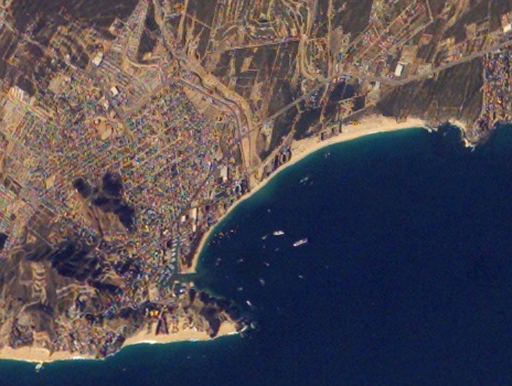
Google EarthGoogle Earth
Google Earth is a virtual globe, map and geographical information program that was originally called EarthViewer 3D, and was created by Keyhole, Inc, a Central Intelligence Agency funded company acquired by Google in 2004 . It maps the Earth by the superimposition of images obtained from satellite...
has high resolution photographs of the corridor, Cabo San Lucas
Cabo San Lucas
Cabo San Lucas , commonly called Cabo, is a city at the southern tip of the Baja California peninsula, in the municipality of Los Cabos in the Mexican state of Baja California Sur. As of the 2010 census, the population was 68,463 people...
and parts of San José del Cabo
San José del Cabo
The city of San José del Cabo is located in Baja California Sur Mexico and is the seat of the municipality of Los Cabos at the south end of the Baja California peninsula. In the 2010 census it had a population of 69,788. Together with neighboring Cabo San Lucas it forms a major tourist destination...
.