

List of neighbourhoods in Edmonton
Encyclopedia
This is a list of residential neighbourhoods in Edmonton
, Alberta
, Canada
. Unlike the category list, neighbourhoods are grouped geographically so that, to a greater or lesser degree, a neighbourhood is grouped with other neighbourhoods that are geographically close.
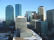
Downtown Edmonton
The downtown core of Edmonton, officially named as Downtown, is generally bounded by 109 Street to the west, 104 Avenue to the north, 97 Street to the east, Jasper Avenue to the southeast, and 97 Avenue, 100 Avenue, and Rossdale Road to the south.
 Districts (unofficial) within the downtown core:
 The following neighbourhoods are immediately adjacent to the downtown core, and are sometimes considered, unofficially, to be part of downtown. They fall completely within an area bounded by the North Saskatchewan River
on the south and south east, 82 Street to the east, 112 Avenue on the north, and 124 Street on the west.
with Edmonton in 1964. Prior to amalgamation, Jasper Place stretched from 118 Avenue to the north to the North Saskatchewan River in the south, and from 149 Street in the east to 170 Street in the west. The town's main street was Stony Plain Road
.
on the north, Anthony Henday Drive on the east, the future Lessard Road extension on the south and 215 Street (Winterburn Road) on the west.
on the north, Anthony Henday Drive on the east, Whitemud Drive
on the south and 231 Street on the west.
Old Strathcona
The following neighbourhoods are located near the University of Alberta, in the area former occupied by the City of Strathcona
, in an area of southwest Edmonton bounded by the North Saskatchewan River to the north, the Whitemud Creek Ravine and the North Saskatchewan River to the west, Calgary Trail to the east, and 61 Avenue to the south.
Ellerslie
Ellerslie is an area bounded by Gateway Boulevard
to the west, Anthony Henday Drive to the north, 66 Street
to the east and the city limits (41 Avenue SW) to the south. It includes four residential neighbourhoods, including one under the same name, and one industrial neighbourhood. The residential neighbourhoods approved to date include:
The Meadows
The Meadows is an area east of Mill Woods that will include seven neighbourhoods when fully developed. It is bounded by 34 Street on the west, Whitemud Drive on the north, and Anthony Henday Drive (Highway 216) on the south and east. Neighbourhoods approved for development to date include:
Mill Woods
Mill Woods is further divided into eight communities. The communities with their respective neighbourhoods are:
Burnewood
Lakewood
Millhurst
Millbourne
Ridgewood
Southwood
Woodvale
, as well as those neighbourhoods north of 111 Avenue and west of 121 Street.
and 137 Avenue, east by Ray Gibbon Drive
, southeast by Anthony Henday Drive (Highway 216), south by Yellowhead Trail (Highway 16), and west by 231 Street (Hillview Road). The City of St. Albert
and Parkland County
are located beyond 137 Avenue and 231 Street respectively. This does not include the Big Lake Estates subdivision at the northeast corner of Yellowhead Trail and 231 Street.
, the east by 97 Street
, and the west by 127 Street
. This does not include Griesbach (east of Castle Downs Road
, south of 153 Avenue south). Castle Downs was once the location of the Edmonton International Speedway
. (Year subdivision established in brackets).
Beverly
These neighbourhoods are located in the area that was part of, or located near, the Town of Beverly
prior to its amalgamation with Edmonton on December 31, 1961. Those areas near the town had coal mines for which the town provided the workforce.
to the west, Anthony Henday Drive to the north, 66 Street
to the east and 153 Avenue
to the south.
to the west, Anthony Henday Drive to the north and east, and 153 Avenue
to the south. Four of the five residential neighbourhoods planned to date include:
in the Alberta economy in the mid to late 2000s, vacancy rates reached an all time low. At the same time, rents and other housing costs continued to increase without a comparable cost-of-living increase in the incomes of those living and working in Alberta. This created a housing crisis in Edmonton.
One of the results of this crisis was that small tent cities appeared in many places in the city. Most of these were located near the downtown core
and in the river valley
.
Many of the people living in the tents were working poor
who had not been able to obtain or retain suitable permanent housing. The Government of Alberta instituted a Homelessness and Eviction Prevenention Fund "to provide short-term assistance to prevent Albertans from becoming homeless and to help individuals and families stabilize their shelter arrangements." While people seeking support from the fund were required to provide evidence of need, for example, "an eviction notice or arrears statement from a landlord; and confirmation, such as a bank statement, to show they have limited funds to cover the rent shortfall," Global News reported on July 17, 2007, that there was some abuse by individuals who seemed to be addicted to crack.
See also: Business Improvement District
.
Edmonton
Edmonton is the capital of the Canadian province of Alberta and is the province's second-largest city. Edmonton is located on the North Saskatchewan River and is the centre of the Edmonton Capital Region, which is surrounded by the central region of the province.The city and its census...
, Alberta
Alberta
Alberta is a province of Canada. It had an estimated population of 3.7 million in 2010 making it the most populous of Canada's three prairie provinces...
, Canada
Canada
Canada is a North American country consisting of ten provinces and three territories. Located in the northern part of the continent, it extends from the Atlantic Ocean in the east to the Pacific Ocean in the west, and northward into the Arctic Ocean...
. Unlike the category list, neighbourhoods are grouped geographically so that, to a greater or lesser degree, a neighbourhood is grouped with other neighbourhoods that are geographically close.
Downtown EdmontonDowntown EdmontonDowntown Edmonton is bounded by 109 Street to the west, 105 Avenue to the north, 97 Street to the east, 97 Avenue, 100 Avenue, and Rossdale Road to the south and Jasper Avenue to the southeast , though many people consider part or all of the surrounding neighborhoods to be part of downtown...
The downtown core of Edmonton, officially named as Downtown, is generally bounded by 109 Street to the west, 104 Avenue to the north, 97 Street to the east, Jasper Avenue to the southeast, and 97 Avenue, 100 Avenue, and Rossdale Road to the south.- Arts District
- Commercial Core
- Government CentreDowntown EdmontonDowntown Edmonton is bounded by 109 Street to the west, 105 Avenue to the north, 97 Street to the east, 97 Avenue, 100 Avenue, and Rossdale Road to the south and Jasper Avenue to the southeast , though many people consider part or all of the surrounding neighborhoods to be part of downtown...
- Jasper West
- Mackay Avenue
- Rice Howard WayDowntown EdmontonDowntown Edmonton is bounded by 109 Street to the west, 105 Avenue to the north, 97 Street to the east, 97 Avenue, 100 Avenue, and Rossdale Road to the south and Jasper Avenue to the southeast , though many people consider part or all of the surrounding neighborhoods to be part of downtown...
- Warehouse District
Neighbourhoods adjacent to Downtown
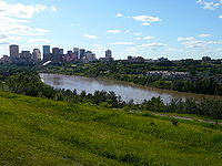
North Saskatchewan River
The North Saskatchewan River is a glacier-fed river that flows east from the Canadian Rockies to central Saskatchewan. It is one of two major rivers that join to make up the Saskatchewan River....
on the south and south east, 82 Street to the east, 112 Avenue on the north, and 124 Street on the west.
- Boyle Street
- Central McDougall
- McCauleyMcCauley, EdmontonMcCauley is an inner city neighbourhood in Edmonton, Alberta. It is named for the Matthew McCauley, the first mayor of Edmonton, and is located just to the north east of the downtown core...
- OliverOliver, EdmontonOliver is one of the oldest residential neighbourhoods in the City of Edmonton, Alberta, Canada. The neighbourhood is named after Frank Oliver, an early Edmonton resident, businessman, and politician...
- Grandin
- Queen Mary Park
- RiverdaleRiverdale, EdmontonRiverdale is a river valley neighbourhood located just east of the downtown core in the city of Edmonton, Alberta, Canada. Its boundaries on the east and south are the North Saskatchewan River. Immediately across the river to the south is another Edmonton river valley neighbourhood--Cloverdale...
- Rossdale
Other neighbourhoods in Inner Edmonton
These neighbourhoods are located north of 111 Avenue, south of Yellowhead Trail, west of the LRT right of way, and east of 121 Street. The Edmonton City Centre Airport is also located within this area.- Alberta AvenueAlberta Avenue, EdmontonAlberta Avenue is a pre–World War II neighbourhood in Edmonton, Alberta, Canada.-The Alberta Avenue neighbourhood:Alberta Avenue is one of the older residential neighbourhoods in Edmonton, with much of the area's development occurring during the First World War era...
- CloverdaleCloverdale, EdmontonCloverdale is a river valley neighbourhood in Edmonton, Alberta, Canada located on the south side of the North Saskatchewan River. It is located immediately across the river from the downtown core and the river valley neighborhood of Riverdale. Southside neighborhoods overlooking Cloverdale...
- DeltonDelton, EdmontonDelton is a neighbourhood located in north central Edmonton, Alberta, Canada. It is named after Edmonton businessman and former alderman Edmund Del Grierson. An older area in Edmonton, some houses dating back to 1904...
- EastwoodEastwood, EdmontonEastwood is a residential neighbourhood in north central Edmonton, Alberta, Canada. It is one of Edmonton's older neighbourhoods, with development starting in 1906. Today, most of the residential construction dates from after World War II....
- Elmwood ParkElmwood Park, EdmontonElmwood Park is a neighbourhood in north central Edmonton, Alberta, Canada.Most of the residential construction in the neighbourhood occurred between the end of World War II and 1970. During this time, roughly two out of every three residences were constructed.Just over half the residences in the...
- ParkdaleParkdale, EdmontonParkdale is a central neighbourhood in Edmonton, Alberta, Canada located a short distance north of the downtown core. Located just to the south of the neighbourhood is Commonwealth Stadium and just to the north east is Rexall Place...
- Prince RupertPrince Rupert, EdmontonPrince Rupert is a triangle-shaped residential neighbourhood in north west Edmonton, Alberta, Canada. Prince Rupert is located within the old Hudson's Bay Reserve and was developed after the end of World War II...
- Spruce Avenue
- StrathearnStrathearn, EdmontonStrathearn is a roughly triangular shaped residential neighbourhood in south central Edmonton, Alberta, Canada. Most of the development in Strathearn dates to the 1940s and 1950s....
- WestwoodWestwood, EdmontonWestwood is a residential neighbourhood in north central Edmonton, Alberta, Canada, located just east of the Edmonton City Centre Airport. The Northern Alberta Institute of Technology and Kingsway Mall are located just to the south west of the neighbourhood....
West Edmonton
West Edmonton includes the neighbourhoods within an area bounded by 124 Street on the east, the city limits on the west, 111 Avenue on the north, and the North Saskatchewan River on the south.Jasper Place
These neighbourhoods were part of the Town of Jasper Place, which amalgamatedAmalgamation (politics)
A merger or amalgamation in a political or administrative sense is the combination of two or more political or administrative entities such as municipalities , counties, districts, etc. into a single entity. This term is used when the process occurs within a sovereign entity...
with Edmonton in 1964. Prior to amalgamation, Jasper Place stretched from 118 Avenue to the north to the North Saskatchewan River in the south, and from 149 Street in the east to 170 Street in the west. The town's main street was Stony Plain Road
Stony Plain Road
Stony Plain Road is a major arterial road in west Edmonton, Alberta, Canada. Parkland Highway is an alternative route to the corresponding section of Alberta Highway 16 in Parkland County.-Parkland Highway:...
.
- Britannia Youngstown
- CanoraCanora, EdmontonCanora is a residential neighbourhood in west Edmonton, Alberta, Canada. Canora was originally part of the Town of Jasper Place, and became a part of Edmonton when Jasper Place amalgamated with the city in 1964....
- Elmwood
- GlenwoodGlenwood, EdmontonGlenwood is a large neighbourhood in west Edmonton, Alberta, Canada. The neighbourhood has a mixture of residential and commercial development...
- High ParkHigh Park, EdmontonHigh Park is a neighbourhood in west Edmonton, Alberta, Canada. The neighbourhood became a part of Edmonton when the Town of Jasper Place amalgamated with Edmonton in 1964....
- Jasper ParkJasper Park, EdmontonJasper Park is a neighbourhood in west Edmonton, Alberta, Canada that was once a part of the Town of Jasper Place. It became a part of Edmonton when Jasper Place amalgamated with Edmonton in 1964...
- MayfieldMayfield, EdmontonMayfield is a neighbourhood in west Edmonton, Alberta, Canada named for famed Canadian aviator and bush pilot Wop May.It is bordered on the north by 111 Avenue, the east by 156 Street, to the south by 107 Avenue, and on the west by Mayfield Road....
- LynnwoodLynnwood, EdmontonLynnwood is a residential neighbourhood in west Edmonton, Alberta, Canada. Its location gives residents good access to downtown, the University of Alberta, MacEwan College, and West Edmonton Mall...
- Meadowlark ParkMeadowlark Park, EdmontonMeadowlark Park is a residential neighbourhood in west Edmonton, Alberta, Canada. It was originally part of the Town of Jasper Place, becoming a part of Edmonton when Jasper Place amalgamated with the city in 1964....
- Patricia Heights
- Rio Terrace
- SherwoodSherwood, EdmontonSherwood is a small neighbourhood in west Edmonton, Alberta, Canada. Originally part of the Town of Jasper Place, it became a part of Edmonton when Jasper Place amalgamated with Edmonton in 1964....
- West Jasper Place
- West Meadowlark ParkWest Meadowlark Park, EdmontonWest Meadowlark Park is a residential neighbourhood in west Edmonton, Alberta, Canada located just east of West Edmonton Mall. The area was originally part of the Town of Jasper Place, and became a part of Edmonton when Jasper Place amalgamated with Edmonton in 1964.The neighbourhood is bounded on...
The Grange
The Grange is a group of suburban neighbourhoods in West Edmonton bounded by Whitemud DriveWhitemud Drive
Whitemud Drive is the main east-west freeway in southern Edmonton, Alberta, Canada. It is one of few roads in Edmonton that has controlled access and limited at-grade intersections with traffic signals. It currently functions as a freeway between Anthony Henday Drive in the west and Anthony Henday...
on the north, Anthony Henday Drive on the east, the future Lessard Road extension on the south and 215 Street (Winterburn Road) on the west.
- GlastonburyGlastonbury, EdmontonGlastonbury is a newer residential neighbourhood in west Edmonton, Alberta, Canada.According to the 2001 federal census, all residences in Glastonbury were constructed after 1995....
- GranvilleGranville, EdmontonGranville is a new neighbourhood in west Edmonton, Alberta, Canada.It is bounded on the north by Whitemud Drive and on the west by Winterburn Road....
- The HamptonsThe Hamptons, EdmontonThe Hamptons is a residential neighbourhood in west Edmonton, Alberta, Canada.It is bounded on the west by Winterburn Road, on the east by the Anthony Henday Drive and on the south by 45 Avenue. The north boundary is 62 Avenue...
Lewis Farms
Lewis Farms is a group of suburban neighbourhoods in West Edmonton bounded by Stony Plain RoadStony Plain Road
Stony Plain Road is a major arterial road in west Edmonton, Alberta, Canada. Parkland Highway is an alternative route to the corresponding section of Alberta Highway 16 in Parkland County.-Parkland Highway:...
on the north, Anthony Henday Drive on the east, Whitemud Drive
Whitemud Drive
Whitemud Drive is the main east-west freeway in southern Edmonton, Alberta, Canada. It is one of few roads in Edmonton that has controlled access and limited at-grade intersections with traffic signals. It currently functions as a freeway between Anthony Henday Drive in the west and Anthony Henday...
on the south and 231 Street on the west.
- Breckenridge GreensBreckenridge Greens, EdmontonBreckenridge Greens is a residential neighbourhood in west Edmonton, Alberta, Canada. Development of the neighbourhood is comparatively recent, with most residential construction occurring during the 1990s according to the 2001 federal census....
- Potter GreensPotter Greens, EdmontonPotter Greens is a newer residential neighbourhood in west Edmonton, Alberta, Canada.According to the 2001 federal census, substantially all of the residences in the neighbourhood were built during the 1990s....
- RosenthalRosenthal, EdmontonRosenthal is a neighbourhood in west Edmonton, Alberta, Canada that was established in 2009 through the adoption of the Rosenthal Neighbourhood Structure Plan ....
- SecordSecord, EdmontonSecord is a neighbourhood in west Edmonton, Alberta, Canada that was established in 2007 through the adoption of the Secord Neighbourhood Structure Plan...
- Stewart GreensStewart Greens, EdmontonStewart Greens is a new neighbourhood in west Edmonton, Alberta, Canada.It is bounded on the east by Anthony Henday Drive and on the north by Stony Plain Road....
- Suder GreensSuder Greens, EdmontonSuder Greens is a newer residential neighbourhood in west Edmonton, Alberta, Canada.Development of the neighbourhood is comparatively recent. According to the 2005 municipal census, there were 269 occupied residences in the neighbourhood. Three out of four of these were single family dwellings...
- Webber GreensWebber Greens, EdmontonWebber Greens is a new neighbourhood in west Edmonton, Alberta, Canada.It is bounded on the east by Anthony Henday Drive and on the west by Winterburn Road....
Other West Edmonton
- AldergroveAldergrove, EdmontonAldergrove is a residential neighbourhood in west Edmonton, Alberta, Canada.The neighbourhood is bounded on the north by 87 Avenue, on the east by 178 Street, on the south by Whitemud Drive and on the west by Anthony Henday Drive. The Anthony Henday provides access to destinations to the south of...
- BelmeadBelmead, EdmontonBelmead is a residential neighbourhood in west Edmonton, Alberta, Canada. Residents in Belmead live just to the west of West Edmonton Mall, the largest shopping centre in Canada....
- Callingwood NorthCallingwood, EdmontonCallingwood is an area in west Edmonton, Alberta, Canada. The city formally divides Callingwood into two neighbourhoods, Callingwood North and Callingwood South. Both neighbourhoods are discussed together in this article....
- Callingwood SouthCallingwood, EdmontonCallingwood is an area in west Edmonton, Alberta, Canada. The city formally divides Callingwood into two neighbourhoods, Callingwood North and Callingwood South. Both neighbourhoods are discussed together in this article....
- Cameron HeightsCameron Heights, EdmontonCameron Heights is a new neighbourhood in west Edmonton, Alberta, Canada overlooking the North Saskatchewan River valley.It is bounded on the south by Anthony Henday Drive, on the north and west by a ravine, and on the east by the North Saskatchewan River valley...
- CrestwoodCrestwood, EdmontonCrestwood is a residential neighbourhood in west Edmonton, Alberta, Canada overlooking the North Saskatchewan River valley and nestled between two ravines.-Geography:...
- DecheneDechene, EdmontonDechene is a roughly triangle-shaped residential neighbourhood in west Edmonton, Alberta, Canada. According to the city of Edmonton , "the neighbourhood is named after Joseph M. Dechene, the father of Judge Andre M...
- DonsdaleDonsdale, EdmontonDonsdale is a residential neighbourhood in west Edmonton, Alberta, Canada.Donsdale is a newer neighbourhood...
- EdgemontEdgemont, EdmontonEdgemont is a residential neighbourhood in west Edmonton, Alberta, Canada that was established in 2011 through the adoption of the Edgemont Neighbourhood Area Structure Plan .It was officially named Edgemont on October 17, 2007....
- GariepyGariepy, EdmontonGariépy is a residential neighbourhood in west Edmonton, Alberta, Canada. According to the City of Edmonton , the neighbourhood "was named for Joseph Hormisdas Gariépy, an early pioneer merchant."...
- GlenoraGlenora, EdmontonGlenora is a prime residential neighbourhood in the city of Edmonton, Alberta, Canada, overlooking the North Saskatchewan River valley.Glenora is bounded on the east by Groat Road, on the north by 107 Avenue, on the west by 142 Street, and on the south by the river valley and the McKinnon Ravine...
- GrovenorGrovenor, EdmontonGrovenor is a residential neighbourhood in west Edmonton, Alberta, Canada. It was originally called Westgrove and a professional building on 142 Street still uses that name....
- West Glenora
- Westgrove
- Jamieson PlaceJamieson Place, EdmontonJamieson Place is a residential neighbourhood in west Edmonton, Alberta, Canada. The neighbourhood is named for Colonel F.C. Jamieson.The neighbourhood is bounded on the west by Anthony Henday Drive, on the north by Callingwood Road, on the east by 184 Street, and on the south be Lessard Road...
- La PerleLa Perle, EdmontonLa Perle is a residential neighbourhood in west Edmonton, Alberta, Canada. The neighbourhood is named for a resident who operated a general store in the area in the early. 20th century....
- Laurier HeightsLaurier Heights, EdmontonLaurier Heights is a residential neighborhood in west Edmonton, Alberta, Canada overlooking the North Saskatchewan River valley. A portion of the neighborhood along Buena Vista Road is located in the river valley, and this portion is sometimes called Buena Vista.Most of the residential development...
- Buena Vista
- LymburnLymburn, EdmontonLymburn is a residential neighbourhood located in west Edmonton, Alberta, Canada. It is named for attorney general John F. Lymburn..According to the 2001 federal census, residential development in the neighbourhood began during the 1970s when one in three of the residences in the neighbourhood...
- McQueenMcQueen, EdmontonMcQueen is a residential neighbourhood located in west Edmonton, Alberta, Canada. It is named for the Rev. David George McQueen, who served 43 years as minister at Edmonton's First Presbyterian Church from 1887 to 1930....
- North GlenoraNorth Glenora, EdmontonNorth Glenora is a residential neighbourhood in west Edmonton, Alberta, Canada.Residential development in North Glenora began before 1946 when one in twenty of the residences were built according to the 2001 federal census. The majority of the residential construction occurred during the fifteen...
- OleskiwOleskiw, EdmontonOleskiw is a residential neighbourhood in west Edmonton, Alberta, Canada that overlooks the North Saskatchewan River valley to the east and south...
- Ormsby PlaceOrmsby Place, EdmontonOrmsby Place is a residential neighbourhood in west Edmonton, Alberta, Canada. It is named for the person who developed Edmonton's grid system of streets....
- ParkviewParkview, EdmontonParkview is a residential neighbourhood in west Edmonton, Alberta, Canada overlooking the North Saskatchewan River valley. The neighbourhood is informally split into two smaller neighborhoods, with the portion east of 142 Street called Valleyview and the portion west of 142 Street called Parkview...
- Valleyview
- Place LaRuePlace LaRue, EdmontonPlace LaRue is a largely commercial neighbourhood located in west Edmonton, Alberta, Canada. According to the 2001 federal census, there were only 75 private dwellings located in the neighbourhood...
- Quesnell Heights
- SummerleaSummerlea, EdmontonSummerlea is a neighbourhood located in west Edmonton, Alberta, Canada. This neighbourhood is home to one of Edmonton's best known tourist destinations--West Edmonton Mall...
- Terra LosaTerra Losa, EdmontonTerra Losa is a mixed residential and commercial neighborhood located in west Edmonton, Alberta, Canada.It is bounded on the east by 170 Street, on the south by 95 Avenue, on the west by 178 Street, and on the north by 100 Avenue and 99A Avenue .-Residential development:Terra Losa is a newer...
- ThorncliffThorncliff, EdmontonThorncliff is a neighbourhood in west Edmonton, Alberta, Canada located immediately to the south of West Edmonton Mall. According to the neighbourhood description in the City of Edmonton . the neighbourhood was designed to control urban sprawl and improve the delivery of services...
- Wedgewood HeightsWedgewood Heights, EdmontonWedgewood Heights is an irregularly shaped neighbourhood in west Edmonton, Alberta, Canada. According to the City of Edmonton , "most of the roads in Wedgewood Heights are named in honour of well-known Edmontonians."...
- WestmountWestmount, EdmontonWestmount is an established central-west residential neighbourhood in Edmonton, Alberta, Canada. Westmount is wedge shaped with the point in the wedge overlooking the North Saskatchewan River valley, and is geographically close to the downtown core...
- Groat Estates
- WestridgeWestridge, EdmontonWestridge is a residential neighbourhood in west Edmonton, Alberta, Canada.The neighbourhood is bounded to the north and north east by Patricia Ravine and to the south by Wolf Willow Ravine. The south eastern tip overlooks the North Saskatchewan River valley. The western boundary is 170 Street...
- Westview VillageWestview Village, EdmontonWestview Village is a mobile home park located in west Edmonton, Alberta, Canada. It is bounded on all sides by industrial subdivisions, and had a population of 2,269 according to the 2005 Edmonton municipal census....
Southwest Edmonton
Neighbourhoods in southwest Edmonton are those located within the city limits that are south of the North Saskatchewan River and west of Gateway Boulevard. It excludes those neighbourhoods north of University Avenue and Whyte Avenue, which are included under South Central Edmonton.Heritage Valley
A newer area of southwest Edmonton, located at the far southern fringe of the city. Neighbourhoods in Heritage Valley are located south of Anthony Henday Drive, west of Calgary Trail/Highway 2, north of the city limits (41 Avenue SW), and east of the Whitemud Creek Ravine. Heritage Valley neighbourhoods include:- AllardAllard, EdmontonAllard is a neighbourhood in southwest Edmonton, Alberta, Canada that was established in 2007 through the adoption of the Allard Neighbourhood Area Structure Plan ....
- BlackburneBlackburne, EdmontonBlackburne is a newer neighbourhood in south west Edmonton, Alberta, Canada. It is an irregularly shaped neighbourhood whose south west boundary overlooks the Blackmud Creek Ravine. It is bounded by Anthony Henday Drive to the north and by Calgary Trail to the east...
- Blackmud CreekBlackmud Creek, EdmontonBlackmud Creek is a new residential neighbourhood in south west Edmonton, Alberta, Canada.The neighbourhood is bounded on the west by the James Mowat Trail , and on the north by Ellerslie Road...
- CallaghanCallaghan, EdmontonCallaghan is a new neighbourhood in south west Edmonton, Alberta, Canada.It is bounded on the south by 30 Avenue SW and on the east by James Mowatt Trail and the Blackmud Creek Ravine. The north boundary is approximately 21 Avenue SW....
- ChappelleChappelle, EdmontonChappelle is a neighbourhood in southwest Edmonton, Alberta, Canada that was established in 2008 through the adoption of the Chappelle Neighbourhood Area Structure Plan ....
- Heritage Valley Town CentreHeritage Valley Town Centre, EdmontonHeritage Valley Town Centre is a neighbourhood in southwest Edmonton, Alberta, Canada that was established in 2009 through the adoption of the Heritage Valley Town Centre Neighbourhood Area Structure Plan ....
- MacEwanMacEwan, EdmontonMacEwan is a residential neighbourhood in south Edmonton, Alberta, Canada.Approximately half of the residences are single family dwellings according to the 2005 municipal census. Another three in ten are rented apartments and apartment style condominiums. The remaining one in five are duplexes...
- RichfordRichford, EdmontonRichford is a newer neighbourhood in south west Edmonton, Alberta, Canada overlooking the Blackmud Creek Ravine. According the 2005 municipal census, there were 161 residences in the neighbourhood....
- RutherfordRutherford, EdmontonRutherford is a newer neighbourhood in south Edmonton, Alberta, Canada.According to the 2005 municipal census, approximately 85% of the residences in the neighbourhood are single family dwellings. The remainder are mostly duplexes with a small number of row houses...
Kaskitayo/Petrolia
The following neighbourhoods are generally considered part of the area known as Petrolia, Kaskitayo, or Heritage (not to be confused with Heritage Valley). The majority of this area developed between 1965 and 1980. This area is bounded by the Whitemud Creek Ravine to the west, Calgary Trail to the east, Whitemud Drive to the north, and the Blackmud Creek Ravine to the south.- Aspen GardensAspen Gardens, EdmontonAspen Gardens is a residential neighbouthood in south west Edmonton, Alberta, Canada, overlooking the Whitemud Creek Ravine. The neighbourhood "was designed to appeal to individuals and families in search of quiet, affluent residential neighbourhood characterised by larger homes, mature trees, and...
- Blue QuillBlue Quill, EdmontonBlue Quill is a residential neighbourhood located in south west Edmonton, Alberta, Canada. Blue Quill and the adjacent neighbourhood of Blue Quill Estates are named to honour Chief Blue Quill of the Saddle Lake Band....
- Blue Quill EstatesBlue Quill Estates, EdmontonBlue Quill Estates is a residential neighbourhood in south west Edmonton, Alberta, Canada. Both Blue Quill Estates and the adjoining neighbourhood of Blue Quill are named to honour Chief Blue Quill of the Saddle Lake Indian Reserve....
- BearspawBearspaw, EdmontonBearspaw, a residential neighbourhood located in south west Edmonton, Alberta, Canada, is named after the Stony Indian Chief Masgwaahisd . It is located close to the shopping and services located in Century Park, Gateway Boulevard, and South Edmonton Common.According to the 2001 federal census,...
- DugganDuggan, EdmontonDuggan is a residential neighbourhood in south Edmonton, Alberta, Canada. The neighbourhood is "named for J.J. Duggan "....
- ErmineskinErmineskin, EdmontonErmineskin is a residential neighbourhood in south west Edmonton, Alberta, Canada. The neighbourhood is named for Chief Ermineskin of Hobbema.The neighbourhood is bounded on the west by 111 Street, on the south by 23 Avenue, and on the east by Calgary Trail and Gateway Boulevard...
- GreenfieldGreenfield, EdmontonGreenfield is a residential neighbourhood located in south west Edmonton, Alberta, Canada. While the official name of the neighbourhood is Greenfield, some residents will refer to the area as Petrolia. There is a small shopping centre, Petrolia Shopping Centre, located in the neighbourhood...
- KeheewinKeheewin, EdmontonKeheewin is a residential neighbourhood located in south west Edmonton, Alberta, Canada. The name means "eagle" in the Cree language.The neighbourhood is bounded on the west by 111 Street, on the east by Calgary Trail/Gateway Boulevard, and on the north by 23 Avenue. The south boundary is located...
- Rideau ParkRideau Park, EdmontonRideau Park is a residential neighbourhood in south west Edmonton, Alberta, Canada. The name Rideau means curtain in the French Language.The neighbourhood is bounded on the west by 111 Street, on the east by Calgary Trail, on the north by Whitemud Drive, and on the south by 40 Avenue, 106 Street,...
- Royal GardensRoyal Gardens, EdmontonRoyal Gardens is a residential neighbourhood in south west Edmonton, Alberta, Canada. The neighbourhood is bounded on the north by Whitemud Drive, on the east by 111 Avenue, on the south by 40 Avenue, and on the west by 119 Street/121 Street....
- SkyrattlerSkyrattler, EdmontonSkyrattler is a residential neighbourhood in south west Edmonton, Alberta, Canada. The neighbourhood is named after Chief Skyrattler of the Winterburn band....
- SteinhauerSteinhauer, EdmontonSteinhauer is a residential neighbourhood in SW Edmonton. "The neighbourhood is named for a missionary who settled in Alberta during the mid-1800s," Henry Bird Steinhauer....
- Sweet GrassSweet Grass, EdmontonSweet Grass is a residential neighbourhood in south west Edmonton, Alberta, Canada. It is named for Cree Chief Sweet Grass, "who was one of the early west's first conservationists and instrumental in the protection of the Plains Bison."...
- Twin BrooksTwin Brooks, EdmontonTwin Brooks is a residential neighbourhood in south Edmonton, Alberta, Canada. It is located at the confluence of the Whitemud Creek and the Blackmud Creek, hence the origin of the name Twin Brooks. Two artificial lakes are situated in the neighbourhood, with George P...
- Westbrook EstatesWestbrook EstatesWestbrook Estates is a well established neighbourhood "designed to appeal to individuals and families in search of a quiet, high quality residential environment with prestigious, architecturally designed homes on large lots." It is located in south west Edmonton, Alberta, Canada.The neighbourhood...
Old StrathconaOld StrathconaOld Strathcona is an historic district located in south-central Edmonton, Alberta, Canada. Once the commercial core of the separate city of Strathcona, the area is now Edmonton's main arts and entertainment district, and in 2007 was named Alberta's second "Provincial Historic Area"...
and area
The following neighbourhoods are located near the University of Alberta, in the area former occupied by the City of StrathconaStrathcona, Alberta
Strathcona was a city in Alberta, Canada, located on the south of the North Saskatchewan River opposite of the City of Edmonton. It amalgamated with Edmonton on February 1, 1912....
, in an area of southwest Edmonton bounded by the North Saskatchewan River to the north, the Whitemud Creek Ravine and the North Saskatchewan River to the west, Calgary Trail to the east, and 61 Avenue to the south.
- AllendaleAllendale, EdmontonAllendale is a residential neighbourhood located in south west Edmonton, Alberta, Canada. The neighbourhood is named for the Allen family, who farmed the area before it was annexed by the City of Strathcona in 1907....
- Belgravia
- GarneauGarneau, EdmontonGarneau is a well known neighbourhood in the city of Edmonton. It is located just west of the Strathcona neighbourhood and just east of the main University of Alberta campus...
- Grandview HeightsGrandview Heights, EdmontonGrandview Heights is a residential neighbourhood in south west Edmonton, Alberta, Canada. It is built on land owned by the McCauley family in the 1880s....
- McKernanMcKernan, EdmontonMcKernan is a neighbourhood located in south west Edmonton, Alberta, Canada, named for James McKernan, a prominent businessman in the City of Strathcona....
- ParkallenParkallen, EdmontonParkallen is a residential neighbourhood in south Edmonton, Alberta, Canada located just to the east of the University of Alberta farm and the Neil Crawford Centre...
- Queen AlexandraQueen Alexandra, EdmontonQueen Alexandra is a mixed residential and commercial neighbourhood in south west Edmonton, Alberta, Canada. The neighbourhood, once part of the City of Strathcona, is named for Alexandra, the wife of Edward VII of England...
- StrathconaStrathcona, EdmontonStrathcona is a residential neighbourhood in south central Edmonton, Alberta, Canada. It is a part of, and should not be confused with, Old Strathcona, although much of the Strathcona neighbourhood is in Old Strathcona...
- Windsor ParkWindsor Park, EdmontonWindsor Park is a south central neighbourhood in the City of Edmonton, Alberta, Canada. It is located immediately to the west of the University of Alberta north campus and overlooking the North Saskatchewan River valley to the north, west, and south west...
Riverbend
The following neighbourhoods are generally considered part of Riverbend, the area located south and east of the North Saskatchewan River, west of the Whitemud Creek ravine, and a transmission line and utility corridor at roughly 28 Avenue.- Brander GardensBrander Gardens, EdmontonBrander Gardens is a residential neighbourhood located in south west Edmonton, Alberta, Canada overlooking the North Saskatchewan River valley. In the river valley, immediately below the neighbourhood, is Fort Edmonton Park....
- BrooksideBrookside, EdmontonBrookside is a residential neighbourhood in south west Edmonton, Alberta, Canada overlooking the North Saskatchewan River valley and Whitemud Creek ravine.It is bounded to the west and south by Whitemud Drive...
- Bulyea HeightsBulyea Heights, EdmontonBulyea Heights is a residential neighbourhood in the Riverbend area of south west Edmonton, Alberta, Canada. The neighbourhood overlooks Whitemud Creek Ravine. The neighbourhood is named for George H. V...
- Carter CrestCarter Crest, EdmontonCarter Crest is a triangle shaped residential neighbourhood in south west Edmonton, Alberta, Canada. It is bounded on the north west by Terwillegar Drive, on the north east by Rabbit Hill Road, and on the south by a utility corridor located just north of 29 Avenue.According to the 2001 federal...
- Falconer HeightsFalconer Heights, EdmontonFalconer Heights is a residential neighbourhood in south west Edmonton, Alberta, Canada. It is bounded on the west by Riverbend Road, on the north by Rabbit Hill Road, and on the east by Terwillegar Drive...
- Ogilvie RidgeOgilvie Ridge, EdmontonOgilvie Ridge is a residential neighbourhood in south west Edmonton, Alberta, Canada overlooking the Whitemud Creek ravine. It is bounded by the ravine to the east and north...
- Henderson EstatesHenderson Estates, EdmontonHenderson Estates is a residential neighbourhood in south west Edmonton, Alberta, Canada overlooking the North Saskatchewan River valley. The neighbourhood is bounded on the north by Rabbit Hill Road and on the east by Riverbend Road...
- Ramsay HeightsRamsay Heights, EdmontonRamsay Heights is a residential neighbourhood in south west Edmonton, Alberta, Canada overlooking the North Saskatchewan River valley. It is named for Walter Ramsay, who came to the city in 1899 as a teacher and later became the city's first commercial florist....
- Rhatigan RidgeRhatigan Ridge, EdmontonRhatigan Ridge is a residential neighbourhood, overlooking the North Saskatchewan River valley, located in south west Edmonton, Alberta, Canada. It is named for Thomas Rhatigan, an area farmer who was proclaimed "World Oat King" at Toronto's Royal Winter Fair in 1953, 1966 and 1970.The...
Southgate
The following neighbourhoods are located in close proximity to Southgate Centre and, accordingly, are often collectively referred to as the "Southgate" area. These neighbourhoods are bounded by the Whitemud Ravine to the west, Calgary Trail to the east, Whitemud Drive to the south and the University of Alberta Farm and 61 Avenue to the north.- Empire ParkEmpire Park, EdmontonEmpire Park is a residential neighbourhood in south west Edmonton, Alberta, Canada. A major shopping centre, Southgate Centre, is located at the west end of the neighbourhood....
- LansdowneLansdowne, EdmontonLansdowne is a neighbourhood in south west Edmonton, Alberta, Canada overlooking the Whitemud Creek Ravine. The neighbourhood description in the on the City of Edmonton website describes Lansdowne as a neighbourhood with "a quiet pastoral atmosphere and the opportunity to view the rural,...
- Lendrum PlaceLendrum Place, EdmontonLendrum Place is a residential neighbourhood located in south west Edmonton, Alberta, Canada. It is named for Robert Lendrum, an early land surveyor....
- Malmo Plains
- PleasantviewPleasantview, EdmontonPleasantview is a residential neighbourhood in south west Edmonton, Alberta, Canada.The neighbourhood is bounded on the west by 111 Street, on the east by 104 Street/Calgary Trail, on the south by 51 Avenue and on the north by 61 Avenue....
Terwillegar Heights
The following neighbourhoods in southwest Edmonton are generally considered part of Terwillegar, the area located south of a transmission line and utility corridor at roughly 28 Avenue, west of the Whitemud Creek Ravine, north and east of Anthony Henday Drive, and east of the North Saskatchewan River.- HaddowHaddow, EdmontonHaddow is a triangle shaped residential neighbourhood in south west Edmonton, Alberta, Canada. It is bounded on the south west by Anthony Henday Drive and on the south east by Terwillegar Drive. The northern boundary is an undeveloped strip of land about 29 Avenue.The neighbourhood is a newer...
- HodgsonHodgson, EdmontonHodgson is a newer residential neighbourhood located in south west Edmonton, Alberta, Canada, with all residential development occurring after 2001....
- LegerLeger, EdmontonLeger is a newer neighbourhood in the Terwillegar Heights area of south west Edmonton, Alberta, Canada.According to the 2005 municipal census, approximately four out of five homes are single family dwellings. Another 14% are duplexes and 4% are row houses...
- Magrath HeightsMagrath Heights, EdmontonMagrath Heights is a neighbourhood in southwest Edmonton, Alberta, Canada that was established in 2003 through the adoption of the Magrath Heights Neighbourhood Area Structure Plan ....
- MactaggartMactaggart, EdmontonMactaggart is a neighbourhood in southwest Edmonton, Alberta, Canada that was established in 2005 through the adoption of the Mactaggart Neighbourhood Area Structure Plan ....
- Terwillegar TowneTerwillegar Towne, EdmontonTerwillegar Towne is a neighbourhood located in south west Edmonton, Alberta, Canada. It is a newer neighbourhood with all residential construction occurring after 1995....
- Terwillegar SouthTerwillegar South, EdmontonSouth Terwillegar is a neighbourhood in southwest Edmonton, Alberta, Canada that was established in 2003 through the adoption of the South Terwillegar Neighbourhood Area Structure Plan ....
Windermere
One of the newest areas of the city, new neighborhoods began developing in Windermere in 2006. Windermere consists of the area located south of the Anthony Henday Drive, east of the North Saskatchewan River, west of the Whitemud Creek Ravine and north of the city limits (41 Avenue SW).- AmblesideAmbleside, EdmontonAmbleside is a neighbourhood in southwest Edmonton, Alberta, Canada.It is bounded on the north by Anthony Henday Drive, on the south by Ellerslie Road, on the west by 170 Street SW/Terwillegar Drive, and on the east by 141 Street....
- KeswickKeswick, EdmontonKeswick is a neighbourhood in southwest Edmonton, Alberta, Canada that was established in 2010 through the adoption of the Keswick Neighbourhood Structure Plan ....
- Windermere EstatesWindermere Estates, EdmontonWindermere Estates is a neighbourhood in southwest Edmonton, Alberta, Canada, overlooking the North Saskatchewan River valley.It is bounded on the south by the future realignment of Ellerslie Road, on the east by 170 Street SW/Terwillegar Drive, on the northeast by Anthony Henday Drive, and on the...
Southeast Edmonton
Neighbourhoods in southeast Edmonton are those neighbourhoods within the city limits, east of Gateway Boulevard and south of Whyte Avenue. It also includes those neighbourhoods located north of Whyte Avenue, east of 85 Street and south of the North Saskatchewan River. EllerslieEllerslie, EdmontonEllerslie is a newer residential neighbourhood in south Edmonton, Alberta, Canada.The most common type of residence in the neighbourhood is the single family dwelling. According to the 2005 municipal census, two out of every three residences were single-family dwellings...
Ellerslie is an area bounded by Gateway BoulevardGateway Boulevard
Gateway Boulevard is a one-way major arterial in south Edmonton, Alberta, Canada. It is a major commuter route for communities south of Edmonton, such Leduc....
to the west, Anthony Henday Drive to the north, 66 Street
66 Street, Edmonton
66 Street is the designated name of two major arterial roads in east Edmonton, Alberta, Canada, separated by the North Saskatchewan River. The two segments can be connected via the 75 Street-Wayne Gretzky Drive-Fort Road corridor.-North Edmonton:...
to the east and the city limits (41 Avenue SW) to the south. It includes four residential neighbourhoods, including one under the same name, and one industrial neighbourhood. The residential neighbourhoods approved to date include:
- EllerslieEllerslie, EdmontonEllerslie is a newer residential neighbourhood in south Edmonton, Alberta, Canada.The most common type of residence in the neighbourhood is the single family dwelling. According to the 2005 municipal census, two out of every three residences were single-family dwellings...
- The Orchards at EllerslieThe Orchards at Ellerslie, EdmontonThe Orchards at Ellerslie is a neighbourhood in southeast Edmonton, Alberta, Canada that was established in 2007 through the adoption of The Orchards at Ellerslie Neighbourhood Structure Plan ....
- SummersideSummerside, EdmontonSummerside is a newer neighbourhoud in south Edmonton, Alberta, Canada. It is located south of Ellerslie Road and to the west of 66 Street. A portion of the west boundary runs along Parsons Road.The community developer of Summerside is Carma Developers....
The MeadowsThe Meadows, EdmontonThe Meadows is a residential district in the City of Edmonton, Alberta, Canada. Located in southeast Edmonton, The Meadows is bounded by Whitemud Drive to the north, 34 Street to the west, and Anthony Henday Drive to the east and south...
The Meadows is an area east of Mill Woods that will include seven neighbourhoods when fully developed. It is bounded by 34 Street on the west, Whitemud Drive on the north, and Anthony Henday Drive (Highway 216) on the south and east. Neighbourhoods approved for development to date include:- LarkspurLarkspur, EdmontonLarkspur is a south east residential neighbourhood in Edmonton, Alberta, Canada. It is part of The Meadows area, located just to the east of Mill Woods....
- LaurelLaurel, EdmontonLaurel is a neighbourhood in southeast Edmonton, Alberta, Canada that was established in 2007 through the adoption of the Laurel Neighbourhood Structure Plan ....
- MapleMaple, EdmontonMaple is a neighbourhood in southeast Edmonton, Alberta, Canada that was established in 2010 through the adoption of the Maple Neighbourhood Structure Plan ....
- Silver BerrySilver Berry, EdmontonSilver Berry is a newer residential neighborhood in south east Edmonton, Alberta, Canada, located to the east of Mill Woods.Residences in Silver Berry are a mixture of single family dwellings , duplexes and row houses...
- TamarackTamarack, EdmontonTamarack is a newer residential neighborhood in south east Edmonton, Alberta.It is bounded on the south by 23 Avenue, on the north by Whitemud Drive, on the west by 17 Street and on the east by Fulton Nature Reserve and undeveloped spaces...
- Wild RoseWild Rose, EdmontonWild Rose is a residential neighbourhood located in south east Edmonton, Alberta located just to the east of Mill Woods.It is a relatively newer neighbourhood with 86% of the residences being built after 1990 according to the 2001 federal census....
Mill WoodsMill WoodsMill Woods is a residential district in the City of Edmonton, Alberta, Canada. Located in southeast Edmonton, Mill Woods is bounded by Whitemud Drive to the north, 91 Street to the west, 34 Street to the east, and Anthony Henday Drive to the south...
Mill Woods is further divided into eight communities. The communities with their respective neighbourhoods are:- Mill Woods Town CentreMill Woods Town Centre, EdmontonMill Woods Town Centre is best known for its shopping mall and is the commercial centre of the Mill Woods area of Edmonton, Alberta, Canada. What is less well known is that the mall is part of a larger neighbourhood with the same name...
- TawaTawa, EdmontonTawa is a residential neighbourhood in the Mill Woods area of south Edmonton, Alberta, Canada. It is a newer neighbourhood, with most of the development occurring in the early 1990s...
BurnewoodBurnewood, EdmontonBurnewood is a community in the Mill Woods area of Edmonton, Canada that contains the neighborhoods of Jackson Heights and Kiniski Gardens....
- Jackson HeightsJackson Heights, EdmontonJackson Heights is a residential neighbourhood in the Mill Woods area of Edmonton, Alberta, Canada. It is located in the Burnewood area of Mill Woods. The neighbourhood was named in 1976 after Annie May Jackson...
- Kiniski GardensKiniski Gardens, EdmontonKiniski Gardens is a triangle-shaped residential neighbourhood in the Mill Woods area of south east Edmonton, Alberta, Canada. It is part of the Burnewood area of Mill Woods, and is named for Julia Kiniski, a local reform politician of the 1960s....
LakewoodLakewood, EdmontonLakewood is a community in the Mill Woods area of Edmonton, Alberta, Canada. It contains the neighbourhoods of*Kameyosek*Meyonohk*Tipaskan...
- KameyosekKameyosek, EdmontonKameyosek is a residential neighbourhood located in the Mill Woods area of south Edmonton, Alberta, Canada. It is a part of the Mill Woods community of Lakewood...
- MeyonohkMeyonohk, EdmontonMeyonohk is a residential neighbourhood located in the Mill Woods area of south Edmonton, Alberta, Canada. It is a part of the Mill Woods community of Lakewood. The name means "an ideal spot" in the Cree language."...
- TipaskanTipaskan, EdmontonTipaskan is a residential neighbourhood located in the Mill Woods area of south Edmonton, Alberta, Canada. It is a part of the Mill Woods community of Lakewood...
MillhurstMillhurst, EdmontonMillhurst is a community in the Mill Woods area of Edmonton, Canada that contains the neighborhoods of Meyokumin and Sakaw. These two neighbourhoods fall within an area bounded by 66 Street on the west, 50 Street on the east, 23 Avenue on the north, and Anthony Henday Drive on the south. The two...
- MeyokuminMeyokumin, EdmontonMeyokumin is a residential neighbourhood located in the Mill Woods area of south Edmonton, Alberta, Canada. It is a part of the Mill Woods community of Millhurst...
- SakawSakaw, EdmontonSakaw is a residential neighbourhood located in the Mill Woods area of south Edmonton, Alberta, Canada. It is a part of the Mill Woods community of Millhurst. The name means "wooded area" in the Cree language."...
MillbourneMillbourne, EdmontonMillbourne is a community in the Mill Woods area of Edmonton, Canada that contains the neighborhoods of Lee Ridge, Michaels Park, Richfield and Tweddle Place....
- Lee RidgeLee Ridge, EdmontonLee Ridge is a residential neighbourhood located in the Mill Woods area of south Edmonton, Alberta, Canada, named after former Edmonton mayor Robert Lee....
- Michaels ParkMichaels Park, EdmontonMichaels Park is a residential neighbourhood in the Millbourne community of Mill Woods in south east Edmonton, Alberta, Canada. It is named for "John Michaels who was involved in community service for 50 years and was best known for his promotion of aviation and the north country."According to the...
- RichfieldRichfield, EdmontonRichfield is a residential neighbourhood in the Millbourne area of Mill Woods, part of south east Edmonton, Alberta, Canada.According to the 2001 federal census, the bulk of residential construction in the neighbourhood occurred during the 1970s when roughly three out of four of residences were...
- Tweddle PlaceTweddle Place, EdmontonTweddle Place is a residential neighbourhood in the Millbourne community in the Mill Woods area of Edmonton, Alberta, Canada. It is named for a former city commissioner, Malcolm Tweddle....
RidgewoodRidgewood, EdmontonRidgewood is a community in the Mill Woods area of Edmonton, Canada that contains the neighborhoods of Bisset, Minchau and Weinlos....
- BissetBisset, EdmontonBisset is a residential neighbourhood located in the Mill Woods area of Edmonton, Alberta, Canada. The neighbourhood "is named for Judge Athelstan Bisset, Q.C." It is a part of the Mill Woods community of Ridgewood....
- MinchauMinchau, EdmontonMinchau is a roughly triangle shaped residential neighbourhood in the Mill Woods area of Edmonton, Alberta, Canada. It is named for August Minchau, a Prussian immigrant who settled in the Mill Woods area in the late 19th century....
- WeinlosWeinlos, EdmontonWeinlos is a residential neighbourhood located in the Mill Woods area of Edmonton, Alberta, Canada. While some homes in the neighbourhood were constructed during the 1970s, most residential construction occurred during the 1980s....
SouthwoodSouthwood, EdmontonSouthwood is a community in the Mill Woods area of Edmonton, Canada that contains the neighborhoods of Crawford Plains, Daly Grove and Pollard Meadows....
- Crawford PlainsCrawford Plains, EdmontonCrawford Plains is a residential neighbourhood located in the Mill Woods area of south Edmonton, Alberta, Canada. It is a part of the Mill Woods community of Southwood...
- Daly GroveDaly Grove, EdmontonDaly Grove is a residential neighbourhood located in the Mill Woods area of south Edmonton, Alberta, Canada. It is a part of the Mill Woods community of Southwood...
- Pollard MeadowsPollard Meadows, EdmontonPollard Meadows is a residential neighbourhood located in the Mill Woods area of south Edmonton, Alberta, Canada. It is a part of the Mill Woods community of Southwood....
WoodvaleWoodvale, EdmontonWoodvale is a community in the Mill Woods area of Edmonton, Canada that contains the neighborhoods of Greenview and Hillview....
- GreenviewGreenview, EdmontonGreenview is a residential neighbourhood in the Mill Woods area of south east Edmonton, Alberta, Canada. It is located to the south of the Mill Woods Golf Course....
- HillviewHillview, EdmontonHillview is a residential neighbourhood in the Mill Woods area of south Edmonton, Alberta, Canada. It is located in the Woodvale area of Mill Woods.The neighbourhood was largely developed during the 1970s and early 1980s...
Other Southeast Edmonton
- ArgyllArgyll, EdmontonArgyll is a residential neighbourhood in Edmonton, Alberta, Canada, located on the south side of the city between the two branches of the Mill Creek Ravine. It is bounded by the ravine on the west and north east sides, and by Argyll Road on the south and south east sides. On the other side of...
- AvonmoreAvonmore, EdmontonAvonmore is a residential neighbourhood in south east Edmonton, Alberta, Canada. It is in the shape of an irregular quadrilateral bounded on the south east by Argyll Road, on the south west by Mill Creek Ravine, on the north by 76 Avenue and on the east by 75 Street. It is surrounded by a mixture...
- Bonnie DoonBonnie Doon, EdmontonBonnie Doon is a neighbourhood in south-central Edmonton, Alberta, Canada. The western part of Bonnie Doon was originally part of the City of Strathcona, and became a part of Edmonton when Strathcona and Edmonton merged in 1912...
- CapilanoCapilano, EdmontonCapilano is a residential neighbourhood in south east Edmonton, Alberta, Canada. The neighbourhood, established in the 1950s, overlooks the scenic North Saskatchewan River valley....
- CharlesworthCharlesworth, EdmontonCharlesworth is a new neighbourhood in south east Edmonton, Alberta, Canada.It is bounded on the south by Ellerslie Road, on the west by 66 Street, and on the east by 50 Street and on the north by Anthony Henday Drive....
- Forest HeightsForest Heights, EdmontonForest Heights is a residential neighbourhood in south east Edmonton, Alberta, Canada that overlooks the North Saskatchewan River valley to the north and west...
- Fulton PlaceFulton Place, EdmontonFulton Place is a residential neighbourhood in south east Edmonton, Alberta, Canada. It is named for the creek which runs along the neighbourhood's west boundary. The area is also sometimes known as Hardisty....
- Hardisty
- Gold BarGold Bar, EdmontonGold Bar is a residential neighbourhood in south east Edmonton, Alberta, Canada.The neighbourhood's west boundary is 50 Street. The northern boundary follows a zig zag path running north east from 50 Street until it reaches the Gold Bar Ravine...
- HazeldeanHazeldean, EdmontonHazeldean is a residential neighbourhood in south east Edmonton, Alberta, Canada. The neighbourhood overlooks the Mill Creek Ravine.The neighbourhood is bounded on the west by 99 Street, on the south by 63 Avenue, on the east by the Mill Creek Ravine, and on the north by 72 Avenue.- Residential...
- HolyroodHolyrood, EdmontonHolyrood is a residential neighbourhood in the Bonnie Doon area of south east Edmonton, Alberta, Canada. The name, Holyrood, is an anglicisation of the Scots haly ruid ....
- IdylwyldeIdylwylde, EdmontonIdylwylde is a residential neighbourhood in south east Edmonton, Alberta, Canada.According to the 2001 federal census, just over half of the residences in the neighbourhood were built between the end of World War II and 1960. Another one in four were built between 1961 and 1980...
- KenilworthKenilworth, EdmontonKenilworth is a residential neighbourhood in south east Edmonton, Alberta, Canada located just to the north of Whyte Avenue.According to the 2001 federal census, approximately eight out of ten of the residences in the neighbourhood were built during the 1960s...
- King Edward ParkKing Edward Park, EdmontonKing Edward Park is a residential neighbourhood on south east Edmonton, Alberta, Canada. The neighbourhood was originally annexed by Edmonton in 1912....
- Maple RidgeMaple Ridge, EdmontonMaple Ridge is a mobile home park located in south east Edmonton, Alberta, Canada. It is bounded on all sides by industrial subdivisions, and had a population of 1564 according to the 2005 Edmonton municipal census....
- OttewellOttewell, EdmontonOttewell is a large residential neighbourhood in south east Edmonton, Alberta, Canada. "The area is named for the Ottewell family, who were among the first settlers south of the river in the 1880s"....
- RitchieRitchie, EdmontonRitchie is a residential neighbourhood in south east Edmonton, Alberta, Canada. It is named for the original owner of the Ritchie Mill and former mayor of the City of Strathcona...
- Terrace HeightsTerrace Heights, EdmontonTerrace Heights is a roughly triangle-shaped residential neighbourhood in south east Edmonton, Alberta, Canada.According to the 2001 federal census, most of the development in the neighbourhood occurred in the first fifteen year after World War II. It was during this time that 84% of the...
- WalkerWalker, EdmontonWalker is a new neighbourhood in south east Edmonton, Alberta, Canada.It is bounded on the north by Ellerslie Road, on the west by 66 Street, and on the east by 50 Street. To the south is an undeveloped rural area of Edmonton....
Northwest Edmonton
Northwest Edmonton includes those neighbourhoods located inside the city limits that are north of Yellowhead Trail and west of 97 Street97 Street, Edmonton
97 Street is a major arterial road in north Edmonton, Alberta, Canada. It is used to take travelers in and out of Downtown Edmonton to the city's northern suburban neighbourhoods and communities such as CFB Edmonton. The neighbourhood along the west side, between 137 and 153 Avenues, Griesbach,...
, as well as those neighbourhoods north of 111 Avenue and west of 121 Street.
Big Lake
Big Lake is bounded on the north by Big LakeBig Lake (Alberta)
Big Lake is a lake in central Alberta, Canada. It is located adjacent to the northwest corner of Edmonton and the southwest corner of St. Albert. Its primary inflow is the Sturgeon River...
and 137 Avenue, east by Ray Gibbon Drive
Ray Gibbon Drive
Ray Gibbon Drive, referred to as the West Regional Road during proposal and planning stages, is a developing freeway in west St. Albert, Alberta, Canada. Except for the Edmonton portion, it is only partially constructed as a two-lane road, it will form part of a future realigned Highway 2. Once...
, southeast by Anthony Henday Drive (Highway 216), south by Yellowhead Trail (Highway 16), and west by 231 Street (Hillview Road). The City of St. Albert
St. Albert, Alberta
St. Albert is a suburban city in Alberta, located northwest of Edmonton, on the Sturgeon River. It was originally settled as a Métis community, and is now the second largest city in the Edmonton area. St...
and Parkland County
Parkland County, Alberta
Parkland County is a municipal district in central Alberta, Canada.It is located west of Edmonton in Census Division No. 11, along the Parkland Highway...
are located beyond 137 Avenue and 231 Street respectively. This does not include the Big Lake Estates subdivision at the northeast corner of Yellowhead Trail and 231 Street.
- Hawks RidgeHawks Ridge, EdmontonHawks Ridge is a neighbourhood in northwest Edmonton, Alberta, Canada that was established in 2010 through the adoption of the Big Lake Neighbourhood Three Neighbourhood Structure Plan , which was renamed as the Hawks Ridge NSP in July 2011....
- StarlingStarling, EdmontonStarling is a neighbourhood in northwest Edmonton, Alberta, Canada that was established in 2010 through the adoption of the Big Lake Neighbourhood Two Neighbourhood Structure Plan ....
- TrumpeterTrumpeter, EdmontonTrumpeter is a neighbourhood in northwest Edmonton, Alberta, Canada that was established in 2008 through the adoption of the Big Lake Neighbourhood One Neighbourhood Structure Plan ....
Castle Downs
Castle Downs is bounded on the north by the Transportation and Utility Corridor (Anthony Henday Drive), the south by 137 Avenue137 Avenue, Edmonton
137 Avenue is a major arterial road in north Edmonton, Alberta, Canada. This road travels through residential, industrial and commercial areas, including shopping and entertainment centres and districts....
, the east by 97 Street
97 Street, Edmonton
97 Street is a major arterial road in north Edmonton, Alberta, Canada. It is used to take travelers in and out of Downtown Edmonton to the city's northern suburban neighbourhoods and communities such as CFB Edmonton. The neighbourhood along the west side, between 137 and 153 Avenues, Griesbach,...
, and the west by 127 Street
127 Street, Edmonton
127 Street is a major arterial road in north Edmonton, Alberta, Canada. It takes commuters from central Edmonton to the north neighbourhoods and Sturgeon Valley Subdivisions...
. This does not include Griesbach (east of Castle Downs Road
Castle Downs Road
Castle Downs Road is an arterial road in north-west Edmonton, Alberta, Canada. It was built in the 1970s by realigning 112 Street and 167 Avenue during the construction of the new Castle Downs neighbourhood. Its south end starts at the CN Rail Yards, and at 137 Avenue it changes name from 113A...
, south of 153 Avenue south). Castle Downs was once the location of the Edmonton International Speedway
Edmonton International Speedway
Edmonton International Speedway, also known as Speedway Park, was a multi-track auto racing facility located in the present Cumberland and Hudson neighborhoods of Edmonton, Alberta, Canada. The facility featured a ¼ mile drag strip, a 14-turn road course, and a ¼ mile short oval...
. (Year subdivision established in brackets).
- BaranowBaranow, EdmontonBaranow is a neighbourhood in the Castledowns area of north Edmonton, Alberta, Canada. There is some commercial development at the south end of the neighbourhood along 137 Avenue. Development of the neighbourhood occurred in two periods. The first period occurred between the end of World War II...
- BaturynBaturyn, EdmontonBaturyn is a residential neighbourhood in the Castledowns area of north Edmonton, Alberta, Canada. A main artery, 97 Street, gives access to CFB Edmonton located just to the north of the city, as well as access to the downtown core and the Northern Alberta Institute of Technology.According to the...
- BeaumarisBeaumaris, EdmontonBeaumaris is a residential neighbourhood in the Castledowns area of northwest Edmonton, Alberta, Canada. It is named for Beaumaris Castle in Wales....
- CaernarvonCaernarvon, EdmontonCaernarvon is a residential neighbourhood in the Castledowns area of north Edmonton, Alberta, Canada. It is named for a castle in Wales.According to the 2001 federal census, the majority of residential construction in the neighbourhood occurred during the 1970s and early 1980s...
- CanossaCanossa, EdmontonCanossa is a residential neighbourhood in the Castledowns area of north Edmonton, Alberta, Canada. As with all north end neighbourhoods, its location makes it an attractive place for people who work on CFB Edmonton, but choose to live off base....
- CarlisleCarlisle, EdmontonCarlisle is a residential neighbourhood in the Castledowns area of north west Edmonton, Alberta, Canada. The neighbourhood is named for Carlisle Castle in England....
- ChamberyChambery, EdmontonChambery is a new neighbourhood in the Castledowns area of north west Edmonton, Alberta, Canada. It is bounded on the west by 112 Street. The south boundary is half a block north of 173 A Avenue. To the north is Edmonton's Rural North West. It is named for the Château de Chambéry in France...
- DunluceDunluce, EdmontonDunluce is a residential neighbourhood located in the Castledowns area of north Edmonton, Alberta, Canada. It is named for a castle in Northern Ireland. The Castledowns Recreation Centre is located at the south east corner of the neighborhood....
- ElsinoreElsinore, EdmontonElsinore is a neighbourhood near the north end of the city of Edmonton, Alberta, Canada. It is one of the neighborhoods within the Edmonton district of Castledowns. To the north lies largely rural, undeveloped land within the Edmonton city limits...
- LoreleiLorelei, EdmontonLorelei is a residential neighbourhood located in the Castledowns area of north Edmonton, Alberta, Canada.It is bounded on the north and west by Castledowns Road, on the east by 97 Street, and on the south by Beaumaris Road and 160 Avenue...
- RapperswillRapperswill, EdmontonRapperswill is a new neighbourhood in the Castledowns area of north west Edmonton, Alberta, Canada. It is bounded on the west by 127 Street and on the south by 167 Avenue. The eastern boundary is one half block west of 119 Street. To the north is Edmonton's Rural North West.As of September 23,...
The Palisades
The Palisades is bound by Anthony Henday Drive to the north, 142 Street to the west, 137 Avenue to the south and 127 Street to the east.- AlbanyAlbany, EdmontonAlbany is a neighbourhood in northwest Edmonton, Alberta, Canada that was established in 2009 through the adoption of the Albany Neighbourhood Structure Plan ....
- CarltonCarlton, EdmontonCarlton is a residential neighbourhood in the Palisades area of north west Edmonton, Alberta, Canada.According to the 2005 municipal census, the most common type of dwelling in the neighbourhood is the single family dwelling. These account for roughly nine out of ten of all residences in the...
- CumberlandCumberland, EdmontonCumberland is a residential neighbourhood in the Palisades area of north west Edmonton, Alberta, Canada.According to the 2001 federal census, substantially all residential construction in Cumberland occurred during the 1990s. Single family dwellings account for approximately nine out of ten of...
- HudsonHudson, EdmontonHudson is a newer residential neighbourhood in north west Edmonton, Alberta, Canada. Before development, the site was home of Edmonton International Speedway, a drive-in theatre, and a driving range....
- OxfordOxford, EdmontonOxford is a residential neighbourhood in the Palisades area of north west Edmonton, Alberta, Canada.According to the 2001 federal census, residential development of the neighbourhood began in the second half of the 1980s and continued through the 1990s. Nine out of ten of residences in the...
- PembinaPembina, EdmontonPembina is a largely commercial neighbourhood in north west Edmonton, Alberta, Canada with a small number of residences in walk up apartment buildings....
Other Northwest Edmonton
- AthloneAthlone, EdmontonAthlone is a residential neighbourhood in north west Edmonton, Alberta, Canada. The neighbourhood is named for the Earl of Athlone, Canada's Governor-General from 1940-46...
- Dunvegan
- CalderCalder, EdmontonCalder is a residential neighbourhood in north west Edmonton, Alberta, Canada. The area was originally part of the Hudson's Bay Company reserve and was settled by employees of the Grand Trunk Pacific Railway....
- DovercourtDovercourt, EdmontonDovercourt is a residential neighbourhood in north west Edmonton, Alberta, Canada. While the area was originally annexed by the City of Edmonton in 1913, residential development didn't occur until after the end of World War II....
- Goodridge CornersGoodridge Corners, EdmontonGoodridge Corners is a future neighbourhood in northwest Edmonton, Alberta, Canada.It is located on the edge of Edmonton, bounded on the west by the city's boundary with St. Albert , north by the city's boundary with Sturgeon County, east by the future realignment of 112 Street, and south by...
- GriesbachGriesbach, EdmontonGriesbach is a residential neighbourhood in the Castledowns area of north west Edmonton, Alberta, Canada. This neighbourhood was formerly a military base, part of CFB Edmonton...
- InglewoodInglewood, EdmontonInglewood is a residential neighbourhood in north west Edmonton, Alberta, Canada.Between 1946 and 1996, Edmonton's Charles Camsell Hospital was located in the neighbourhood...
- KensingtonKensington, EdmontonKensington is a residential neighbourhood in north west Edmonton, Alberta, Canada. While the land was annexed by Edmonton in 1913, development of the neighbourhood didn't occur until much later....
- LauderdaleLauderdale, EdmontonLauderdale is a residential neighbourhood in north west Edmonton, Alberta, Canada. It is named for "James Lauder who farmed and owned land near the neighbourhood before the turn of the 20th century"....
- Prince CharlesPrince Charles, EdmontonPrince Charles is a residential neighbourhood in north west Edmonton, Alberta. The area was named in honour of the Prince of Wales.The neighbourhood is bounded on the north by the Yellowhead Trail, on the west by 127 Street, on the east by 121 Street, and on the south by 118 Avenue...
- RosslynRosslyn, EdmontonRosslyn is a residential neighbourhood in north west Edmonton, Alberta, Canada. The neighbourhood has good access to shopping services at Northgate Centre and North Town Mall....
- SherbrookeSherbrooke, EdmontonSherbrooke is a residential neighbourhood in north west Edmonton, Alberta, Canada.It is bounded on the north by the Yellowhead Trail, on the east by 127 Street, on the south by 118 Avenue, and on the west by St. Albert Trail...
- WellingtonWellington, EdmontonWellington is a residential neighbourhood located in north west Edmonton, Alberta, Canada.The neighbourhood was developed after World War II with approximately two out of three of residences built between 1946 and 1960. Another one in four residences were built during the 1960s...
- WoodcroftWoodcroft, EdmontonWoodcroft is a neighbourhood located in north west Edmonton, Alberta, Canada. Coronation Park and the Telus World of Science are located in the neighbourhood. The neighbourhood is surrounded by a mixture of residential neighborhoods and light industrial subdivisions...
Northeast Edmonton
Northeast Edmonton includes neighbourhoods within the city limits located north of Yellowhead Trail and east of 97 Street, as well as those neighbourhoods located south of the Yellowhead Trail, north of the North Saskatchewan River, and east of the LRT right-of-way. BeverlyBeverly, AlbertaBeverly is a former urban municipality within the Edmonton Capital Region of Alberta, Canada. Beverly incorporated as a village in 1913 and became the Town of Beverly on July 10, 1914. It later amalgamated with the City of Edmonton on December 30, 1961....
These neighbourhoods are located in the area that was part of, or located near, the Town of BeverlyBeverly, Alberta
Beverly is a former urban municipality within the Edmonton Capital Region of Alberta, Canada. Beverly incorporated as a village in 1913 and became the Town of Beverly on July 10, 1914. It later amalgamated with the City of Edmonton on December 30, 1961....
prior to its amalgamation with Edmonton on December 31, 1961. Those areas near the town had coal mines for which the town provided the workforce.
- AbbottsfieldAbbottsfield, EdmontonAbbottsfield is a neighbourhood in east Edmonton, Alberta, Canada overlooking the North Saskatchewan River valley. The neighbourhood is named for Abraham Abbott, a resident of the Town of Beverly and long time school custodian in the Beverly School District...
- Beacon HeightsBeacon Heights, EdmontonBeacon Heights is a residential neighbourhood in Edmonton, Alberta, Canada that was part of the Town of Beverly before Beverly amalgamated with Edmonton in 1961....
- BergmanBergman, EdmontonBergman is a neighbourhood in east Edmonton, Alberta, Canada located immediately to the north of the Town of Beverly townsite. The neighbourhood is named for Gustav C...
- Beverly Heights
- Rundle Heights
Casselman-Steele Heights
- CasselmanCasselman, EdmontonCasselman is a residential neighbourhood located in north east Edmonton, Alberta, Canada. It is named after a lawyer who practiced in Edmonton during the early part of the 20th century....
- EbbersEbbers, EdmontonEbbers is a neighbourhood in northeast Edmonton, Alberta, Canada that was established in 2006 through the adoption of the Ebbers Neighbourhood Area Structure Plan ....
- McLeodMcLeod, EdmontonMcLeod is a residential neighbourhood in north east Edmonton, Alberta, Canada.The neighbourhood is bounded on the south by 144 Avenue, on the north by 153 Avenue, on the east by 58 Street and on the west by 66 Street....
- MillerMiller, EdmontonMiller is a triangle shaped residential neighbourhood located in north east Edmonton, Alberta, Canada.It is bounded on the north by 153 Avenue, on the west by 50 Street, and on the south east by the Canadian National Railway right of way and Manning Drive....
- YorkYork, EdmontonYork is a neighbourhood in north east Edmonton, Alberta, Canada located just to the west of the District of Clareview. It is bounded on the north by 144 Avenue, the east by 50 Street, the south east by Manning Drive, the south by 137 Avenue, and on the west by 66 Street.Four out of five occupied...
Clareview
- BannermanBannerman, EdmontonBannerman is a residential neighbourhood in the Clareview area of north east Edmonton, Alberta, Canada. It is named after "H. Bannerman, who settled in the Belmont area in 1883."...
- BelmontBelmont, EdmontonBelmont is a residential neighbourhood located in the Clareview area of north east Edmonton, Alberta, Canada.The neighbourhood is bounded on the north by 137 Avenue, on the east by Victoria Trail, and on the west by 40 Street...
- Clareview CampusClareview Campus, EdmontonClareview Campus is a mixed use neighbhourhood located in the Clareview area of north east Edmonton, Alberta, Canada. The neighbourhood is bounded on the south by 137 Avenue, on the west by the Canadian National Railways right of way, on the north by 144 Avenue, and on the east by 36...
- FraserFraser, EdmontonFraser is a residential neighbourhood in north east Edmonton, Alberta, Canada. Like many of the neighbourhoods in the Clareview area, it is centred about an elementary school and community hall with the same name...
- HairsineHairsine, EdmontonHairsine is a residential neighbourhood in north east Edmonton, Alberta, Canada.The neighbourhood is bounded on the east by Victoria Trail, on the west by 36 Street, on the north by 144 Avenue and on the south by 137 Avenue....
- KernohanKernohan, EdmontonKernohan is a residential neighbourhood located in the Clareview area of north east Edmonton, Alberta, Canada. It is "named for an early pioneer farmer who operated a grocery store here in the 1880s and 90s....
- KirknessKirkness, EdmontonKirkness is a residential neighbourhood in the Clareview area of north east Edmonton, Alberta, Canada. It is named for James Kirkness who came to the Edmonton area in 1866 as an employee of the Hudson's Bay Company. "A local park is named for James A...
- Sifton ParkSifton Park, EdmontonSifton Park is a residential neighbourhood in the Clareview area of north east Edmonton, Alberta, Canada.The neighbourhood is bounded on the north by 137 Avenue, on the west by 50 Street, and on the east by 40 Street...
Hermitage
- Canon RidgeCanon Ridge, EdmontonCanon Ridge is a residential neighbourhood in the Hermitage area of north east Edmonton, Alberta, Canada. It "is named for an Anglican minister who arrived in Edmonton in 1875." The neighbourhood overlooks the North Saskatchewan River valley....
- HomesteaderHomesteader, EdmontonHomesteader is a residential neighbourhood in the Hermitage area of north east Edmonton, Alberta, Canada.The neighbourhood is bounded on the south by Yellowhead Trail, on the west by 50 Street, and on the north by Kennedale Ravine. To the south of Hermitage Road, the eastern boundary is...
- OverlandersOverlanders, EdmontonOverlanders is a residential neighbourhood in the Hermitage area of northeast Edmonton, Alberta, Canada.The neighbourhood is bounded on the east by Victoria Trail, on the south by Yellowhead Trail, and on the north by Kennedale Ravine. To the south of Hermitage Road, the western boundary is...
Lake District
Lake District is a grouping of nine neighbourhoods bounded by 97 Street97 Street, Edmonton
97 Street is a major arterial road in north Edmonton, Alberta, Canada. It is used to take travelers in and out of Downtown Edmonton to the city's northern suburban neighbourhoods and communities such as CFB Edmonton. The neighbourhood along the west side, between 137 and 153 Avenues, Griesbach,...
to the west, Anthony Henday Drive to the north, 66 Street
66 Street, Edmonton
66 Street is the designated name of two major arterial roads in east Edmonton, Alberta, Canada, separated by the North Saskatchewan River. The two segments can be connected via the 75 Street-Wayne Gretzky Drive-Fort Road corridor.-North Edmonton:...
to the east and 153 Avenue
153 Avenue, Edmonton
153 Avenue is a major arterial road in north Edmonton, Alberta, Canada. It is currently separated between by an industrial subdivision that has been rezoned for residential, at Manning Drive and Fort Road...
to the south.
- Crystallina NeraCrystallina Nera, EdmontonCrystallina Nera is a neighbourhood in northeast Edmonton, Alberta, Canada that was established in 2007 through the adoption of the Crystallina Nera Neighbourhood Structure Plan ....
- Eaux Claires
- JovizJoviz, EdmontonJoviz is a future neighbourhood in northeast Edmonton, Alberta, Canada. Subdivision and development of the neighbourhood will be guided by the future Joviz Neighbourhood Structure Plan once adopted by Edmonton City Council....
- KlarvattenKlarvatten, EdmontonKlarvatten is a residential neighbourhood in north Edmonton, Alberta, Canada. Its location gives residents good access to CFB Edmonton.It is bounded on the south by 167 Avenue, on the east by 82 Street, and on the west by 91 Street...
- Lago Lindo
- MayliewanMayliewan-Ozerna, EdmontonMayliewan-Ozerna is located in north east Edmonton, Alberta, Canada. The City of Edmonton formally divides the area into two neighbourhoods, Mayliewan and Ozerna. Because the two neighbourhoods are sometimes collective referred to as if they were one neighbourhood, they are discussed here together...
- OzernaMayliewan-Ozerna, EdmontonMayliewan-Ozerna is located in north east Edmonton, Alberta, Canada. The City of Edmonton formally divides the area into two neighbourhoods, Mayliewan and Ozerna. Because the two neighbourhoods are sometimes collective referred to as if they were one neighbourhood, they are discussed here together...
- SchonseeSchonsee, EdmontonSchonsee is a new neighbourhood in north east Edmonton, Alberta, Canada.It is bounded on the south by 167 Avenue, on the east by 66 Street, and on the west by 82 Street. To the north is an undeveloped rural area of Edmonton....
Pilot Sound
Pilot Sound is a grouping of five residential and two industrial neighbourhoods bounded by 66 Street66 Street, Edmonton
66 Street is the designated name of two major arterial roads in east Edmonton, Alberta, Canada, separated by the North Saskatchewan River. The two segments can be connected via the 75 Street-Wayne Gretzky Drive-Fort Road corridor.-North Edmonton:...
to the west, Anthony Henday Drive to the north and east, and 153 Avenue
153 Avenue, Edmonton
153 Avenue is a major arterial road in north Edmonton, Alberta, Canada. It is currently separated between by an industrial subdivision that has been rezoned for residential, at Manning Drive and Fort Road...
to the south. Four of the five residential neighbourhoods planned to date include:
- BrintnellBrintnell, EdmontonBrintnell is a newer neighbourhood in north east Edmonton, Alberta, Canada. According to the 2005 Municipal Census, there were 154 residences in the neighbourhood...
- Hollick-KenyonHollick-Kenyon, EdmontonHollick-Kenyon is a residential neighbourhood located in north east Edmonton, Alberta, Canada. The neighbourhood is named for aviator Herbert Hollick-Kenyon....
- Matt BerryMatt Berry, EdmontonMatt Berry is a residential neighbourhood in north east Edmonton, Alberta, Canada. It is named for aviator Arthur Massey Berry.According to the 2001 federal census, substantially all residential development in Matt Berry occurred after 1985. Approximately one residence in six were built between...
- McConachieMcConachie, EdmontonMcConachie is a neighbourhood in northeast Edmonton, Alberta, Canada that was established in 2006 through the adoption of the McConachie Neighbourhood Structure Plan ....
Other Northeast Edmonton
- BalwinBalwin, EdmontonBalwin is a residential neighbourhood in north east Edmonton, Alberta, Canada. Originally part of North Edmonton, the area was annexed by the City of Edmonton in 1912....
- Belle RiveBelle Rive, EdmontonBelle Rive is a residential neighbourhood in north Edmonton, Alberta, Canada.It is bounded on the north by 167 Avenue, on the south by 153 Avenue, and on the east by 82 Street...
- BellevueBellevue, EdmontonBellevue is a smaller residential neighbourhood located in north east Edmonton, Alberta, Canada. The neighbourhood overlooks the North Saskatchewan River....
- BelvedereBelvedere, EdmontonBelvedere is a residential neighbourhood in north east Edmonton, Alberta, Canada. It is located on the west side of the Canadian National Railway right of way close to the Belvedere LRT station....
- CromdaleCromdale, EdmontonCromdale is an older inner city residential neighbourhood in north east Edmonton, Alberta, Canada overlooking the North Saskatchewan River valley...
- DelwoodDelwood, EdmontonDelwood is a mature residential neighbourhood in north east Edmonton, Alberta, Canada.It is bounded on the north by 137 Avenue, on the south by 132 Avenue, on the east by 66 Street and on the west by 82 Street. Travel east along 137 Avenue takes residents to the Clareview LRT station. Travel west...
- Evansdale (Dickinsfield)
- Evergreen
- GlengarryGlengarry, EdmontonGlengarry is a residential neighbourhood located in north east Edmonton, Alberta, Canada. Northgate Centre, a major shopping mall, is located in the neighbourhood's north west corner...
- HighlandsHighlands, EdmontonHighlands is a residential neighbourhood in north east Edmonton, Alberta, Canada overlooking the North Saskatchewan River valley. The area was annexed by Edmonton in 1912, and "was named in a contest offering a 50-dollar prize."...
- KildareKildare, EdmontonKildare is a mixed residential/commercial neighbourhood in north east Edmonton, Alberta, Canada. The neighbourhood is named for an Irish county....
- KilkennyKilkenny, EdmontonKilkenny is a residential neighbourhood in north east Edmonton, Alberta, Canada. Most of the development in the neighbourhood occurred during the 1960s and 1970s....
- KillarneyKillarney, EdmontonKillarney is a residential neighbourhood located in north east Edmonton, Alberta, Canada. While the area became part of Edmonton in 1913, residential development didn't occur until the 1950s and 1960s....
- MontroseMontrose, EdmontonMontrose is a residential neighbourhood in north east Edmonton, Alberta, Canada. Edmonton's Rexall Place, home of the Edmonton Oilers and Edmonton Oil Kings hockey teams, is located at the southwest corner of the neighbourhood....
- NewtonNewton, EdmontonNewton is a residential neighbourhood located in north east Edmonton, Alberta, Canada. It is named for Reverend William Newton who arrived in Edmonton in 1875....
- Northmount (Dickinsfield)
- Virginia ParkVirginia Park, EdmontonVirginia Park is a neighbourhood in north east Edmonton, Alberta, Canada. It is located between the North Saskatchewan River valley to the south and Northlands Park to the north. Its eastern boundary overlooks Wayne Gretzky Drive...
Tent cities and housing crisis
With the major boomBoom and bust
A credit boom-bust cycle is an episode characterized by a sustained increase in several economics indicators followed by a sharp and rapid contraction. Commonly the boom is driven by a rapid expansion of credit to the private sector accompanied with rising prices of commodities and stock market index...
in the Alberta economy in the mid to late 2000s, vacancy rates reached an all time low. At the same time, rents and other housing costs continued to increase without a comparable cost-of-living increase in the incomes of those living and working in Alberta. This created a housing crisis in Edmonton.
One of the results of this crisis was that small tent cities appeared in many places in the city. Most of these were located near the downtown core
Downtown Edmonton
Downtown Edmonton is bounded by 109 Street to the west, 105 Avenue to the north, 97 Street to the east, 97 Avenue, 100 Avenue, and Rossdale Road to the south and Jasper Avenue to the southeast , though many people consider part or all of the surrounding neighborhoods to be part of downtown...
and in the river valley
North Saskatchewan River
The North Saskatchewan River is a glacier-fed river that flows east from the Canadian Rockies to central Saskatchewan. It is one of two major rivers that join to make up the Saskatchewan River....
.
Many of the people living in the tents were working poor
Working poor
- Definition in the United States :There are several popular definitions of "working poor" in the United States. According to the US Department of Labor, the working poor "are persons who spent at least 27 weeks [in the past year] in the labor force , but whose incomes fell below the official...
who had not been able to obtain or retain suitable permanent housing. The Government of Alberta instituted a Homelessness and Eviction Prevenention Fund "to provide short-term assistance to prevent Albertans from becoming homeless and to help individuals and families stabilize their shelter arrangements." While people seeking support from the fund were required to provide evidence of need, for example, "an eviction notice or arrears statement from a landlord; and confirmation, such as a bank statement, to show they have limited funds to cover the rent shortfall," Global News reported on July 17, 2007, that there was some abuse by individuals who seemed to be addicted to crack.
Business revitalization zones
The business revitalization zone (BRZ) program was established to allow certain commercial areas of the city to administer and promote themselves internally. Many of the zones (or districts) that emerged from this have since acquired a virtual "neighbourhood" status by the people of Edmonton. Most zones now offer a unique street shopping environment (many have restaurants and nightlife too) and have become popular destinations for both Edmontonians and visitors to the city. None of these zones are officially designated as neighbourhoods unto themselves however. The City of Calgary also uses BRZs, and other cities have equivalent systems.See also: Business Improvement District
Business improvement district
A business improvement district is a defined area within which businesses pay an additional tax or fee in order to fund improvements within the district's boundaries. Grant funds acquired by the city for special programs and/or incentives such as tax abatements can be made available to assist...
.
- 124 Street and Area
- 97 Street and Area
- Alberta AvenueAlberta Avenue, EdmontonAlberta Avenue is a pre–World War II neighbourhood in Edmonton, Alberta, Canada.-The Alberta Avenue neighbourhood:Alberta Avenue is one of the older residential neighbourhoods in Edmonton, with much of the area's development occurring during the First World War era...
- Beverly
- Downtown (within the Downtown Commercial Core)
- Fort Road and Area
- Inglewood (within the neighbourhood of Inglewood)
- Kingsway
- Northwest Industrial
- Old StrathconaOld StrathconaOld Strathcona is an historic district located in south-central Edmonton, Alberta, Canada. Once the commercial core of the separate city of Strathcona, the area is now Edmonton's main arts and entertainment district, and in 2007 was named Alberta's second "Provincial Historic Area"...
- Stony Plain Road