
Whitemud Drive
Encyclopedia
Whitemud Drive is the main east-west freeway in southern Edmonton
, Alberta
, Canada
. It is one of few roads in Edmonton that has controlled access and limited at-grade intersections with traffic signals. It currently functions as a freeway between Anthony Henday Drive in the west and Anthony Henday Drive in the east. Its portion from 170 Street
and 75 Street forms part of Edmonton's Inner Ring Road.
, and ends in the east at an interchange with the eastern leg of Anthony Henday Drive (Highway 216) at Edmonton's boundary with Strathcona County
. The road is preceded by the western segment of Highway 628
from Stony Plain
, and succeeded by an eastern segment of Highway 628 to Highway 21. It is signed as Highway 2 between the west leg of Anthony Henday Drive and Calgary Trail
/Gateway Boulevard
, and Highway 14 between Calgary Trail/Gateway Boulevard and the east leg of Anthony Henday Drive.
Over its course, Whitemud Drive passes at-grade signalized intersections at Winterburn Road
(215 Street) and Lewis Estates Boulevard/Guardian Road in the west before passing under the western leg of Anthony Henday Drive (Highway 216), which is accessed through a partially signalized interchange.
Continuing eastward, access is provided through interchanges at 178 Street, 170 Street, 159 Street, 149 Street (limited access), Fox Drive
, 53 Avenue, Terwillegar Drive
, 199/122 Street
, 111 Street
, Calgary Trail/Gateway Boulevard (Highway 2), 99 Street, 91 Street
, 66
/75 Street, 50 Street
, 34 Street
, 17 Street and the eastern leg of Anthony Henday Drive. Along this portion, Whitemud Drive crosses the North Saskatchewan River
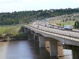
on the Quesnell Bridge
before Fox Drive, Whitemud Creek (its namesake) before 119/121 Street, Mill Creek before 50 Street, and Fulton Creek after 17 Street. It also passes under a Canadian Pacific rail line before 99 Street and over a Canadian National rail line after 17 Street.

The Whitemud extension (Highway 628) through Strathcona County will be divided all the way to Highway 21.
|}
Edmonton
Edmonton is the capital of the Canadian province of Alberta and is the province's second-largest city. Edmonton is located on the North Saskatchewan River and is the centre of the Edmonton Capital Region, which is surrounded by the central region of the province.The city and its census...
, Alberta
Alberta
Alberta is a province of Canada. It had an estimated population of 3.7 million in 2010 making it the most populous of Canada's three prairie provinces...
, Canada
Canada
Canada is a North American country consisting of ten provinces and three territories. Located in the northern part of the continent, it extends from the Atlantic Ocean in the east to the Pacific Ocean in the west, and northward into the Arctic Ocean...
. It is one of few roads in Edmonton that has controlled access and limited at-grade intersections with traffic signals. It currently functions as a freeway between Anthony Henday Drive in the west and Anthony Henday Drive in the east. Its portion from 170 Street
170 Street, Edmonton
170 Street is a major arterial road in west Edmonton, Alberta, Canada. It serves residential, commercial and industrial areas.Gervais / Hebert Road is a major arterial road in south St. Albert, Alberta, Canada. It serves residential and commercial areas.The portion of 170 Street between Whitemud...
and 75 Street forms part of Edmonton's Inner Ring Road.
Route description
Whitemud Drive begins in the west at an unsignalized intersection with 231 Street at Edmonton's boundary with Parkland CountyParkland County, Alberta
Parkland County is a municipal district in central Alberta, Canada.It is located west of Edmonton in Census Division No. 11, along the Parkland Highway...
, and ends in the east at an interchange with the eastern leg of Anthony Henday Drive (Highway 216) at Edmonton's boundary with Strathcona County
Strathcona County, Alberta
Strathcona County is a specialized municipality in central Alberta, Canada between Edmonton and Elk Island National Park.It is located in Division No. 11 and is also part of the Edmonton Census Metropolitan Area. More than half of the population lives in Sherwood Park, a large community east of...
. The road is preceded by the western segment of Highway 628
Alberta Highway 628
Alberta Provincial Highway No. 628 is a highway in the province of Alberta, Canada. It runs west-east through the Edmonton Capital Region in two sections. The first 19 km section runs from the town of Stony Plain to the Edmonton city limits at 231 Street...
from Stony Plain
Stony Plain, Alberta
Stony Plain is a large town in rural Alberta, Canada, just west of Edmonton.Stony Plain is a rapidly growing town with strong historical roots. It is located west of Spruce Grove and surrounded by Parkland County. The town is governed by one mayor and six councillors. The region is dominated by...
, and succeeded by an eastern segment of Highway 628 to Highway 21. It is signed as Highway 2 between the west leg of Anthony Henday Drive and Calgary Trail
Calgary Trail
Calgary Trail is a major one-way arterial in south Edmonton, Alberta, Canada. It is a major commuter route for communities south of Edmonton, such as Leduc....
/Gateway Boulevard
Gateway Boulevard
Gateway Boulevard is a one-way major arterial in south Edmonton, Alberta, Canada. It is a major commuter route for communities south of Edmonton, such Leduc....
, and Highway 14 between Calgary Trail/Gateway Boulevard and the east leg of Anthony Henday Drive.
Over its course, Whitemud Drive passes at-grade signalized intersections at Winterburn Road
Winterburn Road
Winterburn Road is a major arterial road in west Edmonton, Alberta, Canada. It is a rural grid road that earned the name 215 Street when Edmonton expanded this far to the west....
(215 Street) and Lewis Estates Boulevard/Guardian Road in the west before passing under the western leg of Anthony Henday Drive (Highway 216), which is accessed through a partially signalized interchange.
Continuing eastward, access is provided through interchanges at 178 Street, 170 Street, 159 Street, 149 Street (limited access), Fox Drive
Fox Drive
Fox Drive is an arterial road in south-west Edmonton, Alberta, Canada. It is used by motorists travelling from destinations in west and south-west areas of the city to reach destinations in central Edmonton, including: the University of Alberta, Old Strathcona, and the downtown core, because it...
, 53 Avenue, Terwillegar Drive
Terwillegar Drive
Terwillegar Drive is a developing freeway in south-west Edmonton, Alberta, Canada. It is currently still under construction, with the majority of its intersection at-grade, it retains its arterial road status...
, 199/122 Street
119/122 Street, Edmonton
119/122 Street is a major arterial road in south Edmonton, Alberta, Canada. It undergoes a number of name changes through its length.-127 Street SW:127 Street used to be rural grid road Range Road 250 south of Edmonton...
, 111 Street
111 Street, Edmonton
111 Street is a major arterial road in south Edmonton, Alberta, Canada. The south leg of the LRT runs for most of its length, between the northbound and southbound lanes.-Neighbourhoods:...
, Calgary Trail/Gateway Boulevard (Highway 2), 99 Street, 91 Street
91 Street, Edmonton
91 Street is a major arterial road in south Edmonton, Alberta, Canada. It runs parallel with Parsons Road through Edmonton's south industrial parks, then after crossing Anthony Henday Drive, it meets up with, and continues south as Parsons Road. 91 Street once ran parallel down to 41 Avenue SW...
, 66
66 Street, Edmonton
66 Street is the designated name of two major arterial roads in east Edmonton, Alberta, Canada, separated by the North Saskatchewan River. The two segments can be connected via the 75 Street-Wayne Gretzky Drive-Fort Road corridor.-North Edmonton:...
/75 Street, 50 Street
50 Street, Edmonton
50 Street is the designated name of two major arterial roads in east Edmonton, Alberta, Canada, separated by the North Saskatchewan River. It is mostly straight, and runs the entire south-north length of Edmonton...
, 34 Street
34 Street, Edmonton
34 Street is a major arterial road in east Edmonton, and west Strathcona County, Alberta, Canada. It services both residential , and industrial areas. The boundary between the City of Edmonton and Strathcona County runs on the west side of this Right of Way from Sherwood Park Freeway to Baseline Road...
, 17 Street and the eastern leg of Anthony Henday Drive. Along this portion, Whitemud Drive crosses the North Saskatchewan River
North Saskatchewan River
The North Saskatchewan River is a glacier-fed river that flows east from the Canadian Rockies to central Saskatchewan. It is one of two major rivers that join to make up the Saskatchewan River....
on the Quesnell Bridge
Quesnell Bridge
The Quesnell Bridge is a girder bridge that spans the North Saskatchewan River in Edmonton, Alberta, Canada. It is part of Edmonton's largest freeway, Whitemud Drive. On average 120,000 cars pass over the bridge every day.-Construction:...
before Fox Drive, Whitemud Creek (its namesake) before 119/121 Street, Mill Creek before 50 Street, and Fulton Creek after 17 Street. It also passes under a Canadian Pacific rail line before 99 Street and over a Canadian National rail line after 17 Street.
Future
The most recent at-grade intersection to be upgraded to an interchange is 17 Street. The overpass currently has two lanes open eastbound and one lane open westbound. Construction is ongoing, with upgrades to 17 Street from 37A Avenue to north of Whitemud Drive under the overpass being scheduled for completion in 2012. As a result, Whitemud Drive now has no traffic signals between the western and eastern junctions with Anthony Henday Drive.The Whitemud extension (Highway 628) through Strathcona County will be divided all the way to Highway 21.
Interchanges and intersections
Whitemud Drive currently has 20 interchanges, 3 underpasses and 2 overpasses, giving it freeway status (red) for the 24.6 kilometres (15.3 mi) from Anthony Henday Drive on the west side to Anthony Henday Drive on the east side.|}