
List of large council estates in the UK
Encyclopedia
The following is a list of large council estates in the United Kingdom
, identified as estates generally considered to have a population in excess of 10,000 (although population figures are not compiled for many estates, as they do not usually correspond to local government units).
Becontree
in Dagenham is generally considered to be the largest council estate (in terms of population), with Wythenshawe
in Greater Manchester the second largest. Easterhouse
in East Glasgow
, and Bransholme
in Kingston upon Hull
are contenders for third largest.
Dagenham
Birmingham
Leeds
Bradford
Wakefield
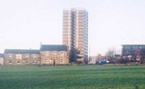
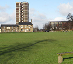
There are three contiguous estates in west Wakefield, which have a combined population of around 18000: Flanshaw
(pop. 6,312), Lupset (pop. 9,116) and Peacock (pop. 2,831).
Glasgow
Edinburgh
United Kingdom
The United Kingdom of Great Britain and Northern IrelandIn the United Kingdom and Dependencies, other languages have been officially recognised as legitimate autochthonous languages under the European Charter for Regional or Minority Languages...
, identified as estates generally considered to have a population in excess of 10,000 (although population figures are not compiled for many estates, as they do not usually correspond to local government units).
Becontree
Becontree
Becontree is a place in the London Borough of Barking and Dagenham, east north-east of Charing Cross.-Becontree estate:The area was developed between 1921 and 1932 by the London County Council as a large council estate of 27,000 homes, intended as "homes for heroes" after World War I. With a...
in Dagenham is generally considered to be the largest council estate (in terms of population), with Wythenshawe
Wythenshawe
Wythenshawe is a district in the south of the city of Manchester, England.Formerly part of the administrative county of Cheshire, in 1931 Wythenshawe was transferred to the City of Manchester, which had begun building a massive housing estate there in the 1920s to resolve the problem of its inner...
in Greater Manchester the second largest. Easterhouse
Easterhouse
Easterhouse is a suburb about east of Glasgow city centre, Scotland. It was partially built on land gained from the county of Lanarkshire as part of a boundary expansion of Glasgow before the Second World War. Building began in the mid-1950s by the then local authority, Glasgow Corporation...
in East Glasgow
Glasgow
Glasgow is the largest city in Scotland and third most populous in the United Kingdom. The city is situated on the River Clyde in the country's west central lowlands...
, and Bransholme
Bransholme
Bransholme is an area and a housing estate on the north-eastern side of Kingston upon Hull, England. The name Bransholme comes from an old Scandinavian word meaning Brand's water meadow ....
in Kingston upon Hull
Kingston upon Hull
Kingston upon Hull , usually referred to as Hull, is a city and unitary authority area in the ceremonial county of the East Riding of Yorkshire, England. It stands on the River Hull at its junction with the Humber estuary, 25 miles inland from the North Sea. Hull has a resident population of...
are contenders for third largest.
DagenhamDagenhamDagenham is a large suburb in East London, forming the eastern part of the London Borough of Barking and Dagenham and located east of Charing Cross. It was historically an agrarian village in the county of Essex and remained mostly undeveloped until 1921 when the London County Council began...
- BecontreeBecontreeBecontree is a place in the London Borough of Barking and Dagenham, east north-east of Charing Cross.-Becontree estate:The area was developed between 1921 and 1932 by the London County Council as a large council estate of 27,000 homes, intended as "homes for heroes" after World War I. With a...
(population over 100,000; the largest public housing development in the world)
BirminghamBirminghamBirmingham is a city and metropolitan borough in the West Midlands of England. It is the most populous British city outside the capital London, with a population of 1,036,900 , and lies at the heart of the West Midlands conurbation, the second most populous urban area in the United Kingdom with a...
- QuintonQuinton, BirminghamQuinton is a suburb on the western edge of Birmingham, England. It is a Birmingham City Council ward within the Edgbaston formal district, and forms a part of the Birmingham Edgbaston parliamentary constituency.The area is served by .-Geography:...
- Druids HeathDruids HeathNot to be confused with Druid's Heath, WalsallDruids Heath is an area of southern Birmingham, United Kingdom. It is located on the A435 road. Nearby settlements include Kings Heath, Kings Norton and Yardley Wood.-Etymology:...
- Kings NortonKings NortonKings Norton is an area of Birmingham, England. It is also a Birmingham City Council ward within the formal district of Northfield.-History:...
- HawkesleyHawkesleyHawkesley is an area of Birmingham, England. It is part of 'The Three Estates', the housing estates Hawkesley, Pool Farm, and Primrose. These are to the south east of Kings Norton...
- ErdingtonErdingtonErdington is a suburb northeast of Birmingham city centre, England and bordering Sutton Coldfield. It is also a council constituency, managed by its own district committee...
- Castle ValeCastle ValeCastle Vale is a housing estate located near Erdington currently Castle Vale votes with Tyburn Ward which is part of Erdington constituency, northeast of Birmingham city centre in England...
- BromfordBromfordBromford is an industrial area of Birmingham, situated between Ward End and Erdington.- Toponomy :In Old English, "Bromford" means "broom ford", signifying abundance of broom shrubs and a location to cross the River Tame....
- HamsteadHamsteadHamstead can refer to:* Hamstead, Isle of Wight* Hamstead, West Midlands**Hamstead railway station* Hamstead Marshall, Berkshire, England.**Hamstead Lock on the Kennet and Avon Canal- See also :*Hampstead *Hempstead...
- CharlemontCharlemontCharlemont is a small village in County Armagh, Northern Ireland. It had a population of 150 people in the 2001 Census. It is situated within the Armagh City and District Council area...
- Perry BeechesPerry BeechesPerry Beeches is an area of Great Barr, Birmingham, England, within the parliamentary constituency of Perry Barr.Previously agricultural, with some sand and gravel quarrying on the site of Asda Queslett; it was developed as a residential suburb of Birmingham immediately before and after World War II...
- New TownNew TownNew Town may refer to:*New town, a generic name for a planned city development or expansion*In the United Kingdom, any of a specific set of towns created under various Acts of Parliament for population moved out of overcrowded conurbations-Places:...
West Yorkshire
LeedsLeedsLeeds is a city and metropolitan borough in West Yorkshire, England. In 2001 Leeds' main urban subdivision had a population of 443,247, while the entire city has a population of 798,800 , making it the 30th-most populous city in the European Union.Leeds is the cultural, financial and commercial...
- Belle IsleBelle Isle, LeedsBelle Isle is a large suburb south of Leeds city centre, West Yorkshire, England. It is bounded to the north and east by the M621 motorway.The district lies in the LS10 Leeds postcode area...
- GiptonGiptonGipton is a suburb of East Leeds, West Yorkshire, England, between the A58 to the north and the A64 to the south. It is joined with Harehills as a City Council Ward...
- SeacroftSeacroftSeacroft is an outer-city suburb consisting mainly of council estate housing covering an extensive area of east Leeds, West Yorkshire, England. It is east of Leeds city centre and lies in the LS14 Leeds postcode area....
(population 18,000) - Halton MoorHalton MoorHalton Moor is a district of east Leeds, West Yorkshire, England, located around three miles east of Leeds city centre and is close to the A63. It is situated between Killingbeck to the north, Temple Newsam to the south, Osmondthorpe to the west and Halton and Colton to the east.The area is mainly...
- Lincoln GreenLincoln GreenLincoln Green is an area of Leeds, West Yorkshire, England. The area is mainly residential with a small local shopping centre. The area also has public houses and a working men's club . Most housing in Lincoln Green is council owned high rise flats, these are in a significantly worse condition then...
(BurmantoftsBurmantoftsBurmantofts is an area of 1960s high-rise housing blocks in inner-city east Leeds, West Yorkshire, England adjacent to the city centre and St. James's Hospital. It is a racially diverse area, with sizable Afro-Caribbean and Irish communities, but suffers the social problems typical of similar areas...
) - Lovell ParkLovell ParkLovell Park is an inner-city area of Leeds, West Yorkshire, England.Lovell Park along with its adjacent areas Little London and Blenheim, is an area of 1960s high-rise and maisonette council housing situated between the city centre and Sheepscar....
- CottingleyCottingley, LeedsCottingley is an urban area in the south-west of Leeds, West Yorkshire, England.Most of Cottingley is a 1960s council estate. The two tower blocks situated on a hill at the centre of the estate are Leeds's tallest flats. In the 1980s, these were in a poor condition, and had particular problems...
- Liitle LondonLittle London, LeedsLittle London, along with its adjacent areas Lovell Park and Blenheim, is an area of 1960s high-rise and maisonette council housing in inner-city north Leeds, West Yorkshire, England, situated between the city centre and Sheepscar....
BradfordBradfordBradford lies at the heart of the City of Bradford, a metropolitan borough of West Yorkshire, in Northern England. It is situated in the foothills of the Pennines, west of Leeds, and northwest of Wakefield. Bradford became a municipal borough in 1847, and received its charter as a city in 1897...
- ButtershawButtershawButtershaw is a residential area of Bradford, West Yorkshire, England. It is bounded by Horton Bank Top to the north, Wibsey to the east, Woodside to the South and Shelf to the west....
- Holme WoodHolme WoodHolme Wood is a housing estate in Bradford, West Yorkshire, England. It borders on Tyersal and also the Leeds boundary. It is the birthplace of actress' Sophie McShera and Jennifer Metcalfe...
(Population 10,000) - RavenscliffeRavenscliffe, West YorkshireRavenscliffe is an area in the Eccleshill ward of the city of Bradford District, in the English county of West Yorkshire. Ravenscliffe is located to the west of Fagley Beck and to the east of the A658 road.-References:...
- AllertonAllerton, West YorkshireAllerton is a former village in Bradford, West Yorkshire, England, now increasingly part of the Bradford conurbation.Chellow Dene is a local beauty spot. This is a wooded valley with two Victorian reservoirs and is a haven for local wildlife....
WakefieldWakefieldWakefield is the main settlement and administrative centre of the City of Wakefield, a metropolitan district of West Yorkshire, England. Located by the River Calder on the eastern edge of the Pennines, the urban area is and had a population of 76,886 in 2001....
There are three contiguous estates in west Wakefield, which have a combined population of around 18000: FlanshawFlanshaw
Flanshaw is a suburb located to the west of Wakefield city centre in West Yorkshire, England. It is administrated by City of Wakefield. Part of the area is a council estate housing estate. The local primary school is Flanshaw J & I School....
(pop. 6,312), Lupset (pop. 9,116) and Peacock (pop. 2,831).
East Riding of Yorkshire
Tyne and Wear
GlasgowGlasgowGlasgow is the largest city in Scotland and third most populous in the United Kingdom. The city is situated on the River Clyde in the country's west central lowlands...
- The Gorbals (Pop. Approx 10,000)
- EasterhouseEasterhouseEasterhouse is a suburb about east of Glasgow city centre, Scotland. It was partially built on land gained from the county of Lanarkshire as part of a boundary expansion of Glasgow before the Second World War. Building began in the mid-1950s by the then local authority, Glasgow Corporation...
(Pop. 26,495) - CastlemilkCastlemilkCastlemilk is a district of Glasgow, Scotland. It lies to the south of the city adjacent to Rutherglen, Croftfoot, Simshill and the separate village of Carmunnock...
(Pop. 18,500) - DrumchapelDrumchapelDrumchapel , known to locals and residents as 'The Drum', is part of the city of Glasgow, Scotland, having been annexed from Dunbartonshire in 1938. It borders Bearsden to the east and Clydebank to the west . The area is bordered by Knightswood and Yoker in Glasgow. The name derives from the...
(Pop. 15,000) - PollokPollokPollok is a large district on the south-western side of the city of Glasgow, Scotland. It was built to house families from the overcrowded inner city...
(Pop. 30,000) - KnightswoodKnightswoodKnightswood is a suburban district in Glasgow, containing 4 areas: Knightswood North or High Knightswood, Knightswood South or Low Knightswood, Knightswood Park and Blairdardie. It has a golf course and park, and good transport links with the rest of the city. Garscadden and Scotstounhill railway...
(Pop. 27,000) - Red RoadRed Road (flats)The Red Road Flats are a high-rise housing complex which lies between the districts of Balornock and Barmulloch in the north east of the city of Glasgow, Scotland. It consists of eight multi-storey blocks. Two are "slabs", much wider in cross-section than they are deep. Six are "points" — more of a...
(Pop. 4,700)
EdinburghEdinburghEdinburgh is the capital city of Scotland, the second largest city in Scotland, and the eighth most populous in the United Kingdom. The City of Edinburgh Council governs one of Scotland's 32 local government council areas. The council area includes urban Edinburgh and a rural area...
- Wester HailesWester HailesWester Hailes is an area in the south west of Edinburgh, Scotland.Depending on the definition, Wester Hailes sometimes takes in Sighthill, the Calders and other surrounding areas, and may be said to contain the areas of Murrayburn, Clovenstone, Westburn and Dumbryden.Wester Hailes borders on...
- West PiltonWest PiltonWest Pilton is a housing estate in Edinburgh, Scotland. It is north of Ferry Road, east of Muirhouse, and immediately west of East Pilton and then Granton....
- MuirhouseMuirhouseMuirhouse is a district in Edinburgh, the capital of Scotland. It is west of Granton and the housing estates of East Pilton and West Pilton, and East of Davidsons Mains...
- NiddrieNiddrie, EdinburghThis article is about Niddrie, a suburb of Edinburgh. See also: Longniddry, Niddry Castle.Niddrie is a suburb of south east Edinburgh, Scotland, UK...
/CraigmillarCraigmillarCraigmillar , from the Gaelic Crag Maol Ard, meaning 'High Bare Rock', is an area of Edinburgh, Scotland, about south east of the city centre, with Duddingston to the north and Newcraighall to the east.- History :...
/GreendykesGreendykesGreendykes is a suburb of Edinburgh, the capital of Scotland. It is a fairly large council scheme, which consists mostly of low-rise flats but also houses two 14 storey tower blocks . It is sometimes considered to be part of Craigmillar, areas such as Niddrie, Niddrie Mains and Newcraighall are... - MoredunMoredunMoredun is a district of Edinburgh, the capital of Scotland. It is east of Liberton, while Craigour is situated just to its north.Originally called Gutters and later Goodtrees, the estate was renamed Moredun in 1769.-Sources:Google Maps...
- OxgangsOxgangsOxgangs is a suburb in the south-west of Edinburgh, Scotland, United Kingdom. It is named for an oxgang, an ancient Scottish land measure.Surrounding districts include Caiystane, Dreghorn, Redford, Fairmilehead, Colinton and Swanston and Colinton Mains...
- BroomhouseBroomhouseBroomhouse is a district of Edinburgh, Scotland. It is mainly residential, low-rise housing. It borders on Sighthill, and Saughton Mains. The Glasgow railway passes to the north but there is no station. The arterial route of Calder Road passes to the south...
/SighthillSighthill, EdinburghSighthill is a suburb in the west of Edinburgh, Scotland.For nearly 50 years, the West Edinburgh skyline was dominated by 4 high rise residential tower blocks the first of which was demolished on 21st September 2008 with the other three blocks following the same fate just over 3 years later...