
List of islands of the Faroe Islands
Encyclopedia
Island
An island or isle is any piece of sub-continental land that is surrounded by water. Very small islands such as emergent land features on atolls can be called islets, cays or keys. An island in a river or lake may be called an eyot , or holm...
s of the Faroe Islands
Faroe Islands
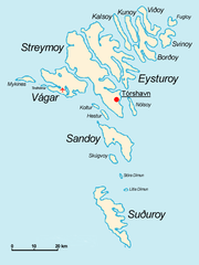
The Faroe Islands are an island group situated between the Norwegian Sea and the North Atlantic Ocean, approximately halfway between Scotland and Iceland. The Faroe Islands are a self-governing territory within the Kingdom of Denmark, along with Denmark proper and Greenland...
. There are 18 islands, of which Lítla Dímun
Lítla Dímun
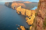
Lítla Dímun is a small island between the islands of Suðuroy and Stóra Dímun in the Faroe Islands. It is the smallest of the main 18 islands, being less than in area, and is the only uninhabited one...
is the only one uninhabited. Besides these 18 islands there are also several islets and skerries in the Faroes
Islets and skerries in the Faroes
Besides the 18 islands of the Faroes there are also several islets and skerries. The Faroe Islands consist of 779 islands, islets and skerries. The islets are small and are geographical parts of the larger islands. Suðuroy consists of 263 islands, islets and skerries, which is the largest number...
.
- BorðoyBorðoyBorðoy is an island in the north-east of the Faroe Islands. There are eight settlements: Klaksvík , Norðoyri, Ánir, Árnafjørður, Strond, Norðtoftir, Depil and Norðdepil. There are also three abandoned settlements: Skálatoftir, Múli and Fossá, all in the north...
- EysturoyEysturoyEysturoy means East island and is the second-largest of the Faroe Islands in the North Atlantic, both in size and population. It is separated by a narrow sound from the main island of Streymoy. Eysturoy is extremely rugged, with some 66 separate mountain peaks, including Slættaratindur, the...
- FugloyFugloyFugloy is the eastern-most island in the Faroe Islands. The name means bird island, and refers to the large number of birds that nest on the island's cliffs.- Geography :...
- HesturHesturHestur is an island in central Faroe Islands, located to the west of Streymoy and to the south of Koltur. Hestur means horse in Faroese. Located on the west coast is a large colony of guillemot. In the north of Hestur there is a moorland with four small lakes, of which Fagradalsvatn is the largest...
- KalsoyKalsoyKalsoy is an island located in the north-east of the Faroe Islands between Eysturoy and Kunoy.- Geography :The western coast has dramatically steep cliffs for the full length of the island, whereas idyllic valleys on the eastern slopes protect the four tiny settlements, Húsar, Mikladalur,...
- KolturKolturKoltur is an island in the Faroe Islands, located to the west of Streymoy and to the north of Hestur. The island has just one settlement: Koltur. It was abandoned in the 1980s by the sheep-farmers whose flocks grazed on the southern part of the island. Since then only two people have returned , and...
- KunoyKunoyKunoy is an island located in the north-east of the Faroe Islands between Kalsoy and Borðoy .- Settlements and transport :...
- Lítla DímunLítla DímunLítla Dímun is a small island between the islands of Suðuroy and Stóra Dímun in the Faroe Islands. It is the smallest of the main 18 islands, being less than in area, and is the only uninhabited one...
- Mykines
- NólsoyNólsoyNólsoy is an island and village in central Faroe Islands, located to the east of the capital Tórshavn in Streymoy. There is only one settlement on the island: Nólsoy on the north-west coast on Stongin, a peninsula attached to the rest of the island by a metres-wide isthmus...
- SandoySandoySandoy is a small island that is part of the Faroe Islands, an autonomous region of the Kingdom of Denmark. The largest population center on the island is the village of Sandur with a population of six hundred....
- SkúvoySkúvoySkúvoy is an island in central Faroe Islands, located to the south of Sandoy. It is named after the large number of skua present on the island . There is only one settlement on the island: Skúvoy on the east coast...
- Stóra DímunStóra DímunStóra Dímun is an island in the southern Faroe Islands, sometimes only referred to as Dímun. The island is accessible from sea only during periods of clear and calm weather, but regular helicopter service is available twice a week through the whole year....
- StreymoyStreymoyStreymoy is the largest and most populated island of the Faroe Islands. The capital, Tórshavn is located there. The name means "island of currents".- Geography :...
- SuðuroySuðuroySuðuroy is the southernmost of the Faroe Islands. The island covers 163.7 km². In 2010 there were 4763 inhabitants, but there has been a gradual decline in the population numbers ever since the 1950s....
- SvínoySvínoySvínoy is an island located in the north-east of the Faroe Islands, to the east of Borðoy and Viðoy. It is divided into two unequally sized peninsulas. The island takes its name from Old Norse, Svíney, meaning "Swine Isle"...
- VágarVágarVágar is one of the 18 islands in the archipelago of the Faroe Islands and the most westerly of the large islands. With a size of 178 km² , it ranks number three, behind Streymoy and Eysturoy....
- ViðoyViðoyViðoy is the northern-most island in the Faroe Islands, located east of Borðoy to which it is linked via a causeway. The name means wood island, despite the fact that no trees grow on the island: the name relates to the driftwood that floats in from Siberia and North America.- Geography :The...
See also
- Geography of the Faroe IslandsGeography of the Faroe IslandsThe Faroe Islands are an island group consisting of eighteen islands off the coast of Northern Europe, between the Norwegian Sea and the North Atlantic, about half-way between Iceland and Norway. Its coordinates are . It is 1,393 square kilometres in area, and includes no major lakes or rivers...
- Subdivisions of the Faroe Islands